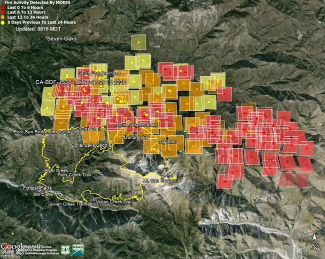
MODIS Fire Detections from June 19. See links below for most recent image
Updated 07/05/15 12:30 p.m. PDT. Added Lake Fire perimeter from GEOMAC timestamped 07/03/15 2335.
The following Google Earth images of MODIS 1km fire detections gives a general idea of the extent of Lake Fire in the San Gorgonio Mountain area of San Bernardino National Forest. The image includes the most recent fire perimeter available from GEOMAC at the time the graphic was created:
Perimeter only timestamped July 3, 2015 at 2335.
Perimeter only timestamped July 1, 2015 at 2324.
Perimeter only timestamped June 28, 2015 at 0200.
Perimeter only timestamped June 25, 2015 at 2356.
June 28, 2015 at 1:45 p.m. PDT – June 26, 2015 at 6:15 a.m. PDT – June 25, 2015 at 6:45 a.m. PDT – June 24, 2015 at 9:00 a.m. PDT – June 23, 2015 at 6:15 a.m. PDT – June 22, 2015 at 7:30 a.m. PDT – June 21, 2015 at 1:15 p.m. PDT – June 19, 2015 at 1:45 p.m. PDT – June 19, 2015 at 7:15 a.m. PDT
For more information see the Lake Fire incident page on InciWeb. As of July 5 8:00 a.m. the fire was reported to be 31,359 acres in size and 90% contained.
Fire detection KML files were generated by the USDA Forest Service MODIS Active Fire Mapping Program. Some additional place names have been added — locations are approximate.
PLEASE NOTE THE FOLLOWING IMPORTANT INFORMATION FROM THE KML FILES:
CONUS MODIS 1km Fire Detections
This KML displays the MODIS fire detections at a spatial resolution of 1km for the past 12 hours, 12-24 hours and the previous 6 day period. Each 1km MODIS fire detection is depicted as a point representing the centroid of the 1km pixel where the fire is detected. The 1km footprint of the MODIS pixel for each detection is also displayed.
KML file generated by the USDA Forest Service MODIS Active Fire Mapping Program. Please see //activefiremaps.fs.fed.us for additional fire mapping products and information.
Disclaimer: Although these data have been used by the USDA Forest Service, the USDA Forest Service shall not be held liable for improper or incorrect use of the data described and/or contained herein. The information contained in these data is dynamic and is continually updated. It is the responsibility of the data user to use the data appropriately and consistent within the limitations of geospatial data in general and these data in particular. Using the data for other than their intended purpose may yield inaccurate or misleading results. The USDA Forest Service gives no warranty, expressed or implied, as to the accuracy, reliability, or completeness of these data. Although these data have been processed successfully on a computer system at the USDA Forest Service, no warranty expressed or implied is made regarding the utility of the data on another system or for general or scientific purposes, nor shall the act of distribution constitute any such warranty. This disclaimer applies both to individual use of the data and aggregate use with other data. The USDA Forest Service reserves the right to correct, update or modify this data and related materials without notification.
