
For official information see the Bobcat Fire incident page on Inciweb and the Angeles National Forest website. National Forests in California have reopened to varying degrees. For more information, contact the National Forest.
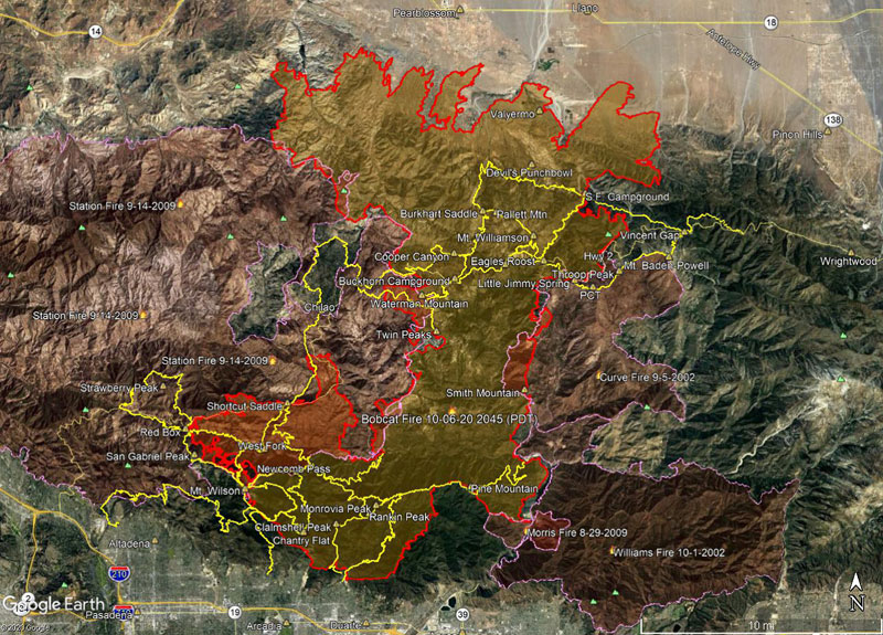
Here’s a Google Earth image of a Bobcat Fire perimeter from the National Interagency Fire Center (NIFC). The area inside the Bobcat perimeter is transparent yellow. Where the Bobcat perimeter overlaps older fire perimeters, the area appears transparent orange. The image acquisition timestamp of the Bobcat perimeter is 10/6/2020 2045 (PDT) .
Also included are adjacent perimeters for the 2002 Curve Fire, 2002 Williams Fire, 2009 Morris Fire and 2009 Station Fire. Some trails in Angeles National Forest are also shown as yellow tracks. All map data are approximate.
Here’s a 3D interactive Cesium view of the 10/6/2020 perimeter and trails.
Angeles National Forest has partially reopened and issued Bobcat Fire Closure Order 05-01-20-08. The maps included in the Closure Order PDF are low resolution and poor quality. CalTopo has created an unofficial, but much more useful map, based on Closure Order.
Update April 2021. The Forest Service has issued Bobcat Fire Closure Order 05-01-21-03, which modifies the previous closure boundary. The Bobcat Closure Area Map is higher resolution than the map included in Order 05-01-20-08. Check the Angeles National Forest website for the most recent Alerts & Notices.
Related post: 3D Terrain View of Bobcat Fire Soil Burn Severity and Some Angeles National Forest Trails