Category Archives: running|adventures

Plan B: Barley Flats

Pines and pine seedlings at Barley Flats

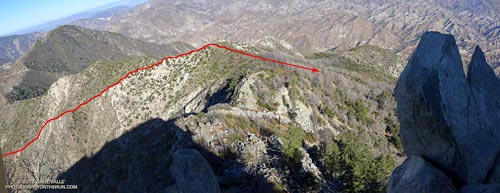
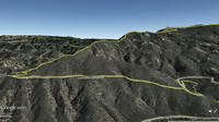
Nearing the junction I debated what to do — turn left on a well-used trail and climb Strawberry Peak or continue straight on an abandoned, overgrown road and go to Barley Flats? If I continued on the road it would be my second bush-whacking adventure of the day. Earlier, I’d abandoned an exploration in upper Colby Canyon when frequent rifle fire made the canyon feel confined and dangerous. This adventure was my plan B.

Overgrown Forest Service fire road connecting Red Box and Barley Flats, built in 1926.
Overgrown Forest Service fire road built in 1926.

Each time I’ve done Strawberry Peak from Red Box I’ve wondered about that overgrown old road. In the book The San Gabriels, John Robinson mentions that it was a Forest Service fire road built in 1926. It’s shown on the USGS 1934 Mt. Lowe and Mt. Wilson Advance Sheets connecting Red Box Gap and Barley Flats and then continuing to Charlton Flats, Chilao and the high country. Back then Angeles Crest Highway didn’t go to Shortcut Saddle, it turned at Red Box and went to the top of Mt. Wilson.

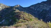
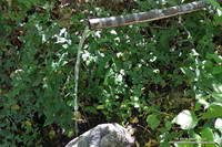
At the junction, I stepped over the rocks marking the left turn toward Strawberry Peak and started up the old road. After about five yards, I almost turned back. The trail was so overgrown it seemed nearly impassable. Yucca and whitethorn conspired to block the way, or at least make it too painful to proceed.

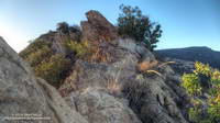
Having done my share of bush-whacking I’ve learned that it’s usually not as bad as it looks. With a little patience the determined hiker can usually find a tolerable way through. That was the case here, but not only was the trail overgrown, there were downed trees and limbs from the 2009 Station Fire, and several small rock slides and wash outs partially blocking the trail.

Barley Flats with Waterman Mountain and Twin Peaks in the background and Mt. Baldy in the distance.
Barley Flats

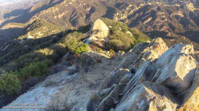
For 2.5 miles I kept repeating, “That wasn’t that bad. I’ll just see what’s around the next corner.” After nearly an hour and a half of seeing what was around the next corner — and almost turning back several times — I finally reached Barley Flats.

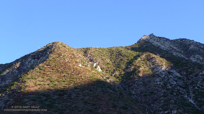
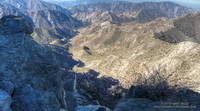
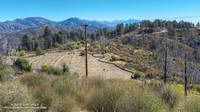
Like many places in the San Gabriels, Barley Flats has a colorful history. In the middle 1800s the site was a favored hideout of horse thieves and cattle rustlers. During the cold war it was one of the many Nike defense sites surrounding Los Angeles. More recently it was a Los Angeles County Sheriff’s Probation Camp and Retreat and today continues to be used as a staging area for LASD’s Air Rescue 5. Much of Barley Flats and the surrounding area was burned in the Station Fire.

Air Rescue 5 airlifts a traffic accident victim from a tight spot on Angeles Crest Highway.
Air Rescue 5 in action on Angeles Crest Highway

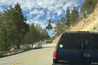
Air Rescue 5 has conducted numerous life-saving missions in Angeles National Forest, including countless air ambulance evacuations from “nearly every corner” of Angeles Crest Highway.

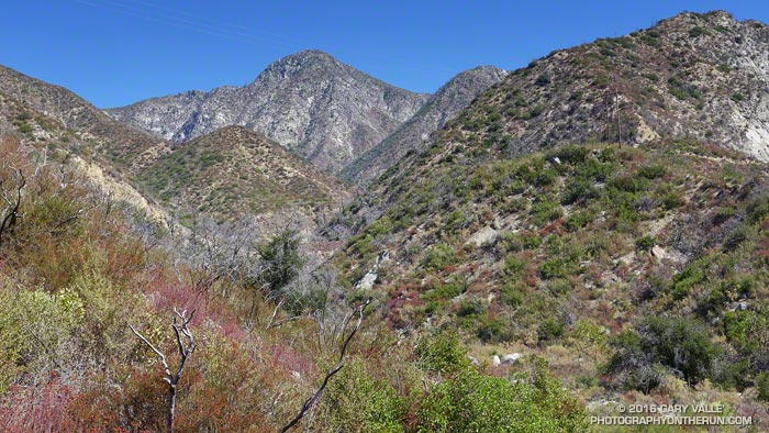
Even before reaching Barley Flats I had decided to take an alternate route back to Red Box. Barley Flats sits on the divide between Upper Tujunga Canyon and the West Fork San Gabriel Canyon. Doing a loop through West Fork sounded a lot more appealing than running the thorny gauntlet back to Red Box on the old road.

It took about one-third of the time to run three miles down paved — and brush-free — Barley Flats Road as it had to bushwhack from Red Box to Barley Flats. There were a few hunters out on Barley Flats road, but all had their rifles shouldered. Since leaving Red Box I had heard only one very distant rifle shot — a big change from the far too frequent rifle fire in Colby Canyon.

From the intersection of (gated) Barley Flats Road and Angeles Crest Highway it was only about 0.7 mile over to Shortcut Saddle. At Shortcut I picked up the Silver Moccasin Trail. As I began to run down the trail toward West Fork, I reached around with one hand and lifted my pack. How much water remained?

Spring at West Fork
Spring at West Fork

The plan was to run down to West Fork, get water, and then run up the Rincon-Red Box fire road to Red Box — completing a loop. The spring at West Fork is usually reliable, but with the drought I couldn’t be 100% sure. Nearby Mt. Wilson was recently forced to close its restrooms and turn off the water spigots used by hikers and runners because of insufficient water.

I was surprised to find the spring was running as strong as it had been in early July during the Mt. Disappointment Endurance Runs. Water was not going to be an issue on the five mile run up to Red Box.

Ducking for Cover

Sunrise in Colby Canyon

When I heard the rifle shot, I was a couple hundred yards off the Colby Canyon Trail, trying to find a way through some thick brush and across a ravine. I reacted to the shot before I heard it, an involuntary spasm of fight or flight snapping me to attention. The high-powered report filled the canyon, echoing off its walls and then continuing to ring for several seconds. Another echoing shot followed and then another.

As I worked back toward the trail, I starting searching for the source of the gunfire. About 100 yards up the canyon, wearing a bright orange vest, a hunter stood in the brush at the edge of the ravine. We waved, each surprised to see the other. Now I understood. Deer hunting season had opened.

A few minutes later more shots followed. What the heck was he shooting at? With the frequency of gunfire, any animal in the canyon would be ducking for cover.

That included me. It was time to give up on this adventure, run down to the trailhead, and go for Plan B.

The Big Pines Trail Marathon — First Organized Mountain Ultra in the U.S?

Mt. Baldy from the North Backbone Trail

What would you think of a 44 mile trail race with 10,000’+ of gain that climbs Mt. Baden-Powell… and Mt. Baldy… by the North Backbone Trail… at night… by the light of a full moon… with the requirement to carry 10 percent of your body weight, NOT including the additional weight of food and water?

Paul V. Engelhardt, winner of the Big Pines Trail Marathon in 1934, 1935 and 1936. Photo: Los Angeles County Department of Parks and Recreation

The Big Pines Trail Marathon was first run on August 23-24, 1934. Based on the description in the Autumn 1934 edition of Trails Magazine, the course would rank high among the toughest mountain courses we run today.

“Starting at Jackson Lake at an elevation of 6,000 feet, it leads over the Blue Ridge Range at 7,800 feet, down to the Big Rock-Vincent Gulch divide, 6,500 feet, up 4 miles by 38 switchbacks to the summit of Mt. Baden-Powell, 9,389 feet, back to the head of Big Rock, and east along the summit of Blue Ridge, over Lookout Peak, 8,505 feet, east over Wright Mountain to the Prairie Fork-Lytle Creek divide at 7,800 feet, over Pine Mountain, 9,661 feet, and Mt. Dawson, 9,551 feet, to the summit of Mt. San Antonio, 10,080 feet. Turning back here, crossing again the saddle at the head of Lytle Creek to the Oak Canyon trail, down through Wrightwood and up to Big Pines Park, where the finish line is at the Davidson Arch, elevation 6,864 feet.”

The winner of the inaugural 41 mile race was 24 year old Paul V. Engelhart, an Assistant Scout Master, in 14 hours, 45 minutes, 15 seconds. Second place went to 17 year old Fairfax High School track team member Bain J. Bain in 14 hours, 48 minutes.

Trails Magazine Big Pines Trail Marathon Trophy. Photo: Los Angeles County Department of Parks and Recreation.

In 1935 the Start was moved to coincide with the Finish at Davidson Arch, increasing the mileage to 44 miles. According to the Trails Magazine report, the race began at 5 p.m., the seven contestants starting at 10-minute intervals.

“This year’s preparations were most complete with nine checking stations, four of which checked two ways, and patrol cars covering all roads which closely paralleled the course for 18 miles. At Guffey Camp, which the contestants passed twice, at 24 miles and 38 miles, there was a field hospital station with a doctor in constant attendance, and on the summit of Mt. San Antonio, 10,000 feet in the air and 32 miles from the start, a four man team from the First Aid and Rescue Division, Disaster Unit, Alhambra Red Cross…”

Engelhardt won again in 1935 in a time of 13 hours and 32 minutes and for the third time in 1936 in a time of 13 hours and 13 minutes. In the Fourth Annual event in 1937 Engelhardt’s record for the 44 mile course was broken by Ray Ebel, who finished in a time of 13 hours 3 minutes.

“In this year’s race, as in those that have gone before, it was decidedly demonstrated that a thorough knowledge of the course is essential to win or even to finish. Of the four who passed Pine Mountain, three were off the course at some point, two of them seriously.”

Winners of the 1938 Fifth Annual Big Pines Trail Marathon. Photo: Los Angeles County Department of Parks and Recreation.

Perhaps in an effort to make the course more straightforward, it was changed for the Fifth Annual race in 1938. Instead of returning from Mt. Baden-Powell and climbing Mt. Baldy via the North Backbone trail, the course continued west along the route of the present day Pacific Crest Trail (and AC100) to Windy Gap. At Windy Gap (then called Islip Saddle) the course descended to Crystal Lake Recreation Camp, turning around at the Ranger Headquarters for the 20 mile return to the Finish at Big Pines.

“It was a wild night on the mountain top, with winter temperatures and a gale of wind, a night which will be long remembered by both the contestants and those in charge of the checking and radio stations. Out of thirteen starters only six finished…”

Even in bad weather, the new forty mile course was more runnable and faster-paced. The report in Trails Magazine describes a competitive race that Big Pines Ski Club member Charles Melhorn won in 9 hours and 23 minutes — just 17 minutes ahead of Marine Reservist Don Wood. That works out to an average pace of 14 min/mile, with much of the running at night!

Strawberry Peak, Switzer’s and the Old Colby Trail

Strawberry Peak and Colby Canyon

The Colby Canyon Trail is one of the historic trails of the San Gabriel Mountains. When Switzer Camp was established in 1884, Colby Canyon was an irresistible gateway leading deeper into the wilderness. The compelling and sometimes snow-covered peak at its head was one of Switzer’s many attractions.

Jason and Owen Brown (1884). Photo: Los Angeles Public LIbrary

In the History of Pasadena Hiram A. Reid recounts the story of how the peak was named in 1886 “by some wags at Switzer’s camp” because of its resemblance to a strawberry. He goes on to describe how one of them irreverently added, “We called it Strawberry peak because there weren‘t any strawberries on it.”

While Strawberry may have been climbed previously, the establishment of Switzer’s made it possible to climb the peak recreationally. In Early Mountain Ascents in the San Gabriels (100 PEAKS Lookout, Jul-Aug 1971) John Robinson notes an 1887 ascent of Strawberry Peak by Owen and Jason Brown — sons of abolitionist John Brown. Robinson describes the “Brown Boys” as the first local “peak baggers.”

Colby Canyon and Arroyo Seco from high on Strawberry Peak.
Colby Canyon and Arroyo Seco from Strawberry Peak.

Climbing Strawberry via Colby Canyon has been a long-time favorite. Last Saturday I’d done Strawberry via Colby Canyon as part of loop — ascending the Colby Canyon Trail to Josephine Saddle, climbing over Strawberry Peak, running down to Red Box and then down the Gabrieleno Trail to Switzer’s. A 0.3 mile connection along Angeles Crest Highway completed the route.

Today I did a variation of the same loop, this time bypassing Josephine Saddle and following (more or less) the route of the old Colby Trail up the ridge at the head of Colby Canyon to Strawberry’s main west ridge.

Overview of the route of the old Colby Trail from Strawberry Peak
Overview of the route of the old Colby Trail

As shown on this USGS Tujunga topo map from 1900, a century ago the Colby Trail was much more direct. It linked Switzer’s Camp in upper Arroyo Seco to the Colby Ranch and other ranches and holdings in Big Tujunga Canyon. It was a much shorter alternative to the roundabout route that ascended to the head of Arroyo Seco (then Long Canyon), and then continued past present day Red Box to Barley Flats and down to Wickiup Canyon. More on the history of Colby Ranch and Big Tujunga Canyon can be found in the Winter 1938 edition of Trails Magazine (12.6 MB PDF).

Ridge that was the route of the old Colby Trail.

A well-used game trail wanders up “Colby” ridge, but the path is far from ideal and not always distinct. Our four-legged friends don’t necessarily follow one path, especially where the route is steep and loose. Deer are well-suited to this kind of terrain, their long, skinny legs being perfect for following an overgrown path lined with thorny buck brush. In a couple of places there were short segments of trail that look like they might be remnants of the trail indicated on the 1900 topo.

Bear tracks on the west side of Strawberry Peak.

It’s easy to understand why the old route on the ridge was abandoned; the route to Josephine Saddle is far better and MUCH faster!

These sections of the 1934 Mt. Lowe Quadrangle advance sheet and 1939 Mt. Lowe Quadrangle shows the dramatic changes in the area with the construction of Angeles Crest Highway (LRN 61) between La Canada and Colby Canyon. The 1934 sheet shows the reroute of the Colby Canyon Trail to Josephine Saddle and then contouring around Strawberry, as well as the trails along the west and east ridges of Strawberry and connecting from Lawlor Saddle to Colby Ranch. The updated 1939 sheet includes the Josephine Fire Lookout and the Josephine Fire Road.

Topanga Lookout Ridge Loop


Looking down Topanga Lookout Ridge

Climbing up a scenic ridge is a great way to start a trail run, especially when it ends at an interesting vantage point and can be extended into a loop.

Googlr Earth view of Topanga Lookout Ridge

The Topanga Lookout Ridge is a mile and a half long ridge that extends from near the junction of Calabasas Peak Motorway and Red Rock Road to the Topanga Lookout.

Well-defined ridges of this length are uncommon in the Santa Monica Mountains, especially those with trails along their crest. This one owes it existence to the Red Rock/Calabasas Peak Fault.

Upthrust rocks along Topanga Lookout Ridge.

The path following the ridge is well-used and generally non-technical, but there are a few spots where it is necessary to scramble up, over, or around a short rocky section.

Normally a mass of graffiti, the lookout currently hosts artwork by @neonsuperblack painted “as a birthday surprise.”

Artwork at Topanga Lookout created by @neonsuperblack.
Artwork at Topanga Lookout

From the Lookout the loop can be completed by following the Topanga Tower Mtwy southwest to the junction of Stunt, Schueren and Saddle Peak roads, then picking up the Backbone Trail and continuing west to the top of the Stunt High Trail. The Stunt High Trail can then be followed down to the trailhead at Cold Canyon Preserve on Stunt Road.

The total length of the loop is a little under 8 miles, with an approximate elevation gain/loss of 2000′. A side trip to Saddle Peak adds about 0.8 mile.

What’s the Fastest Route Up Mt. Baldy?

Baldy Bowl

There’s no getting around it. Sometimes it just feels good to go all out and push the pace up a peak. Just ask the 500+ that do the Mt. Baldy Run to the Top each year.

There are three routes up Mt. Baldy from Manker Flat on which I like to push the pace: the Ski Hut Trail, Register Ridge and the Run to the Top route via the Notch.

The 3.5 mile Register Ridge route is the shortest of the three routes. Since all three routes gain about 3900 feet in elevation, Register Ridge is also the steepest. From where the Register Ridge route leaves the Ski Hut Trail to where it joins the Devil’s Backbone Trail, it gains about 2600′ over about 1.5 miles — an AVERAGE grade of nearly 33%.

Since the Register Ridge route is about a half-mile shorter than the Ski Hut Trail, and the Ski Hut Trail is about 3 miles shorter than the R2T, it might seem either Register Ridge or the Ski Hut Trail would have to be the fastest route to the top of Baldy. For someone equally adept at running and steep hiking, this isn’t necessarily the case.

For a “short” ascent for which fatigue is not a major factor, it’s the elevation gain and not the distance that determines the time. Basically it’s a matter of the rate of climb the runner or hiker can sustain. The winning time of the Baldy R2T is usually just over an hour, which works out to about 3900 ft/hour. Pikes Peak Ascent winners average about 3600 ft/hour.

In round numbers to do Baldy in an hour you need to average:

• 7 mph or 9 min/mile on the R2T course.

• 4 mph or 15 min/mile on the Ski Hut Trail.

• 3.5 mph or 17 min/mile via Register Ridge route.

Following are some Strava Segments associated with these routes and the current Course Records:

Mt Baldy Summit via Ski Hut Trail (3.9 mi)
Brad Harris CR 1:06:58 Apr 17, 2015
Segment starts at Falls Road gate.

Mt. Baldy Run to the Top (6.8 mi)
Lucas Matison CR 1:05:24 Sep 5, 2016
Records are 1:00:49 by Matt Ebiner (1987), and 1:15:32 by Carrie Garritson (1988).
Segment starts at the ski area parking lot. Subtract about 1:00 to compare to the Ski Hut Trail time. This adjusts for running down to the Falls Road gate from the R2T start and for the R2T finish not being quite on the top.

Register to Summit (From base of Register Ridge)
Erik Schulte CR 1:08:56 Jun 19, 2015
Segment starts at the Register Ridge – Ski Hut Trail junction. Add about 10:00 to adjust for the time from Falls Road gate.

So even though the R2T course via the Notch is about 3 miles longer than the Ski Hut Trail route, the fastest (reported) times up Baldy have been by the R2T route. The Ski Hut Trail route is a close second, with the Register Ridge route is a distant third.