Category Archives: pt mugu state park

Woolsey Fire Preliminary Burn Severity and Selected Trails

Google Earth image of a preliminary burn severity map for the Woolsey Fire from NASA Earth Observatory with selected trails added.

The Google Earth image above shows a preliminary burn severity map for the Woolsey Fire from NASA Earth Observatory, as posted by NASA’s Rehabilitation Capability Convergence for Ecosystem Recovery (RECOVER) web site on November 15, 2018. Here is a larger version of the map.

The initial burn severity estimate is based on a Burned Area Reflectance Classification (BARC) derived from satellite data before and after the fire. In the map above the burn severity classes are high (red), moderate (orange) and low (yellow). Note that areas within the fire perimeter that are not included in these classes may still have burned. Also note the fire was still burning when this assessment was made.

GPS tracks of the Backbone Trail and some other trails in the region have been added. Trail and placename locations should be considered approximate.

Related post: Woolsey Fire Map with Perimeter and Selected Trails

Woolsey Fire Map with Perimeter and Selected Trails

2018 Woolsey Fire Map with Perimeter and Selected Trails

The Google Earth image above shows a recent perimeter for the 2018 Woolsey Fire along with GPS tracks of the Backbone Trail and some other trails in the region. The Hill Fire perimeter and 2013 Springs Fire perimeter (purple area) are also shown. Trail and placename locations should be considered approximate. Here is a larger version of the map.

The perimeter was was downloaded from GEOMAC and timestamped November 18, 2018 at 5:59 a.m. If the timestamp of the perimeter of the displayed map doesn’t match, try refreshing/reloading this page. The perimeter has been refined and the acreage is a slightly less than previously specified.

As of November 21, 2018 6:11 p.m., the Cal Fire Incident Page for the Woolsey Fire indicated that the fire had burned 96,949 acres and was 100% contained. The fire started on November 8, 2018 2:24 p.m.

Running Between the Raindrops

Boney Mountain from Serrano Valley

The misty rain had momentarily turned to sunshine. As I ran along the trail, rain-soaked sage glittered in a rainbow of colors. The peaks above me were still shrouded in gray clouds, but the sunlit valley below glowed bright and green. Streams that had been dry on New Years, now burbled and bubbled restlessly. My shoes and socks were soaked, not from stream crossings, but from the cold, wet grass overgrowing the trail.

Dense patches of shooting stars covered wet hillsides and milkmaids lined shady sections of trail. Paintbrush, Indian warrior, California poppies, larkspur, chocolate lilies, bladderpod, encelia, lupine, nightshade, wild hyacinth, phacelia, bigpod ceanothus and wishbone bush had also started to bloom.

The day not only encouraged the accumulation of miles, but of the sensations and emotions of the outdoor experience; and that feeling of well-being that emerges somewhere between the trailhead and the top of the last climb.

Here are a few photos taken along the way.

La Jolla Valley & Mugu Peak from Wendy Drive

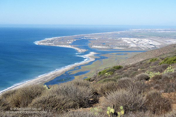
Pt. Mugu from Mugu Peak.

The scat appeared to be a day or two old, and was much bigger than a coyote’s. It was full of fur and could only be from one animal — a mountain lion. The spot had been used before, and it probably wasn’t a coincidence that this was one of the few points along the trail with a good view and nearby cover. I looked into the brush and wondered if unseen eyes looked back.

The sun was well above the horizon, but the first gusts of a developing Santa Ana wind kept the morning cool. No one was on the trail ahead or behind me, and the best I could tell, I was the only two-legged creature within sight.
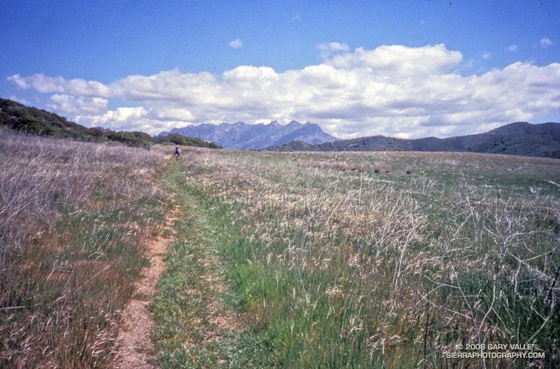

Spring in La Jolla Valley. Boney Mountain in the distance. March 2002.
Walking slowly from the spot, I surveyed the secluded valley. Perched on the edge of the coastal mountains, La Jolla Valley is extraordinary. Surrounded by wind-sculpted peaks, it is situated above and to the west of Big Sycamore Canyon. Its bottom is carpeted with areas of native and non-native grass. Only a tiny percentage of California’s native perennial grasslands remain, and like the big trees, they are relics of the past. Preservation of this native grassland is probably due to the valley’s proximity to the ocean, and its unique microclimate.

Here, trails have been run and peaks climbed for thousands of years. (Charcoal at an archaeological site in the valley has been dated to a maximum age of 7000 B.P.) Above me a raven calls, and Spirit-like, a gust of wind rustles through the grass. Respectfully, I continue running in the direction of Mugu Peak.

The run from Wendy Dr. was more moderate than expected. The first 3 miles of Sycamore Canyon Fire Road are paved, and whether on the fire road, or the single track trails that parallel the road at times, a fast pace can be maintained down to the junction with Wood Canyon Fire Road.

The Wood Canyon Vista Trail/Backbone Trail takes off right (west) from Sycamore Canyon Fire Road a short distance past the Wood Canyon Fire Road junction. It is moderately graded and very runnable. At it’s top a short zig right (north) on the Overlook Fire Road leads to the La Jolla Valley Fire Road, which can be followed left (west) down into La Jolla Valley.

Many, many variations of this course are possible. Here are archived maps of Rancho Sierra Vista/Satwiwa and Pt. Mugu State Park originally from the NPS Santa Monica Mountains web site. Also see the Pt. Mugu State Park maps on VenturaCountyTrails.org.

Depending on whether you want the beta, a little time in Google Earth should help clarify the options. This particular course worked out to about 21 miles, with about 2200 ft. of elevation gain/loss. Here’s a Google Earth image and 3D interactive view of a GPS trace of my route.