Category Archives: photography|landscape

Laguna Peak, La Jolla Valley, and the Channel Islands

Laguna Peak, La Jolla Valley, and the Channel Islands (Anacapa and Santa Cruz) from Boney Mountain.

Wow, it was windy! I was on an exposed ridge between Tri-Peaks and Big Dome, getting pushed around by a unrelenting offshore wind, trying to keep my footing, and take a few photos. About the time I was traversing the ridge, Laguna Peak — the peak in the photograph with all the communications equipment on its summit– recorded a gust of 67 mph.

But this is a mere breeze by Laguna Peak standards. A communication facility operated by the U.S. Navy, the weather station has recorded hurricane force winds on numerous occasions. Several of the wind events listed in the NWS document A History of Significant Weather Events in Southern California reference Laguna Peak. In March of 1991 a gust of 125 mph was recorded at the peak.

Update 12/25/07. Merry Christmas! This morning, about 6:15, Laguna Peak recorded a wind gust of 91.8 mph and several gusts in excess of 85 mph. Between 10:00 a.m. and 11:30 a.m. several gusts over 90 mph were recorded, including one measured at 91.9 mph.

La Jolla Valley is the small valley just below Laguna Peak. Isolated and scenic, it is a “must do” hike or run that can be accessed from the Ray Miller trailhead on PCH, or from Big Sycamore Canyon.

The peak on the left in this wider 16:9 format view is Mugu Peak. Its summit overlooks Pt. Mugu and is a relatively short side trip from the Mugu Trail.

Offshore, two of the Channel Islands can be seen — Anacapa (left) and Santa Cruz.

Chumash View II

View northwest to the Ventura Mountains from the Chumash Trail.

View northwest to the Ventura Mountains from the Chumash Trail. The highest peak on the skyline is Hines Peak (6716′), about 28 miles distant. Here’s a larger version of the 16:9 format image. Note the hawk soaring high above the terrain.

I run the Chumash Trail frequently, but had not seen the bulldozed track on the steep slope near the start of the trail. The trail hasn’t been re-routed. Apparently on the 13th a 4WD truck that was part of a fire department response to a cycling accident got stuck, and a bulldozer was called in to extricate the vehicle. I’ve been told the Park District and Mountains Conservancy are considering next steps.

Boney Mountain – Big Sycamore Canyon Circuit

The Conejo Valley from Boney Mountain.

I liked last weekend’s run so much that this morning I returned to the Wendy Drive trailhead on Potrero Road and was now chugging up the Danielson-Old Boney trail, planning to do another circuit that would eventually take me back down into Big Sycamore Canyon.

Wearing short-sleeves, and without water bottles or packs, a group of three runners passed me as I plodded up the road. I guessed they were headed for the Danielson Monument. That’s where I was going — at least to start. The previous week I had noticed a use trail continuing east from the Danielson cabin site. It was well worn, and a little research confirmed that it was a route up the north flank of Boney Mountain.

My plan was to see where the trail led. That sounds like a given, but trails like this usually have a character of their own, and can lead to interesting areas and variations that demand exploration. Last week a hiker had asked me about this route, and commented that he hoped his group would make it up this time.

It didn’t take long to reach the spur trail to the cabin and monument. I turned left and followed the gently descending trail into the canyon. Where were the other runners? About the time I was beginning to wonder if they were doing an impressively fast and light circuit through Sycamore, I heard fleet-footed voices headed my way. We passed each other at the bottom of the canyon, and I continued the tenth of a mile up to the cabin site and the beginning of my adventure.

The route up the mountain was spectacular! This was not a trail engineered on a piece of paper, but a route that went where possible, following the vagaries and whims of the terrain. A long, sweeping traverse deep in the chaparral would seek a distant ridge and then dive back into the brush before suddenly turning directly and steeply uphill. Views of the valley grew more expansive with each step, and eventually I gained the first summit, marked 2701 ft. on the topo.

From here the trail followed a dramatic ridge, ascending a series of peaklets to a high point at about 2900′, across a canyon and to the north of Tri-Peaks (3010′). My immediate goal was to cross over to Tri-Peaks. From there I would find my way to the Backbone Trail.

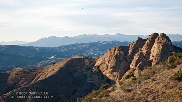
What had been a well trodden path, now became less distinct. From my viewpoint, a route up the north side of Tri-Peaks looked improbable. Choked with brush and trees, the peak was an amalgam of massive volcanic blocks and boulders, fused with chaparral.

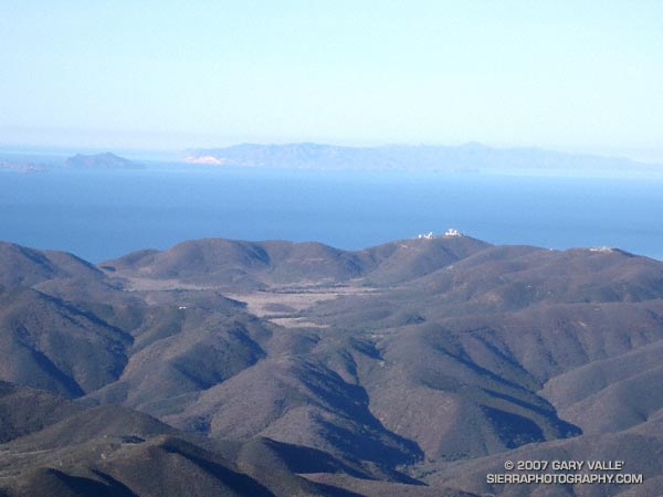
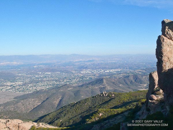
Following the crest of the Boney Mountain escarpment, I dropped down to a saddle. To my right, the terrain plunged between steep cliffs to Big Sycamore Canyon, more than 2500′ below.

Unsure of the route, but endorphin energized, I followed a path up and into a maze of corridors and rooms among the towering rock formations, eventually emerging at the summit block. Working my way out of the shadows, I traversed around to the south side of the peak. From here the Tri-Peaks trail was an obvious slash in the brush and in a few minutes I was on the Backbone Trail, headed west.

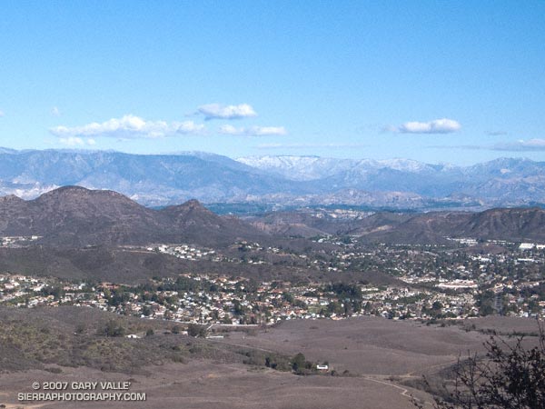
The downhill running on this section of trail is among the best in the Santa Monica Mountains, with memorable views of Boney Mountain’s massive western flank. In five miles and a nearly effortless hour I was down to the Danielson multi-use area.

I stopped for water and briefly debated how far to run down Big Sycamore. Not far — I picked up the Ranch Center fireroad (unpaved) and followed it up to the Hidden Pond trail, finishing the run like last week, on the Upper Sycamore and Danielson/Old Boney trails.

Here’s a Google Earth image and KMZ file of a GPS trace of the approximately 18.5 mile route.

Related post: Big Sycamore Canyon Circuit

Return of the Afternoon Sun

Sunset from the Chumash Trail, Simi Valley, California.

Those of us in the northern hemisphere that enjoy afternoon daylight are celebrating the passing of the dank days of Autumn when sunset occurs the earliest in the day. Depending on your location, the amount of afternoon daylight may already be increasing — be it ever so modest.

According to the Astronomical Applications Dept. of the U. S. Naval Observatory, in Los Angeles that day is today, December 11, when the sunset shifts from 4:44 p.m. to 4:45 p.m.

The more northerly your latitude, the later the date. In Miami it was back on December 4, and in Seattle it will be on December 18. In Anchorage it won’t be until December 20. Barrow, Alaska won’t see a sunset (or sunrise) until January 23!

You can check your city’s sunset times using the USNO Sun or Moon Rise/Set Table.

Big Sycamore Canyon Circuit

Rancho Sierra Vista/Satwiwa and the Conejo Valley with snow on the peaks of the Ventura mountains

I was about a mile from the Wendy Dr. trailhead on Potrero Rd. in Newbury Park. A cold wind ruffled the chaparral, and to the north snow could be seen on McDonald Peak (6870′) and other peaks of the Ventura mountains. I was nearing the top of a rounded ridge in Rancho Sierra Vista/Satwiwa, and in a few minutes would be descending the sun-warmed Old Boney Trail into the upper reaches of Big Sycamore Canyon.

Big Sycamore Canyon extends from the ocean to within a mile or so of Potrero Rd. It forms the main trunk of an extensive network of trails in Pt. Mugu State Park. Of the many possible trail combinations, my loosely defined plan was to link some of the trails on the XTERRA Boney Mountain Trail Run course into a longer run.

The general idea was to start on the Old Boney and Blue Canyon Trails, and return via the Hidden Pond and Upper Sycamore Canyon Trails. I was looking to do about 20 miles, and wasn’t sure how far down Big Sycamore I would run, or what other trails I would do.

The run up and over the shoulder of Boney Mountain was brisk and blustery. On the way I checked out the waterfall spur trail and the Danielson cabin site and monument. At one point, several miles into the run, the trail rounded a ridge and descended into a bowl at the head of a broad canyon. Here, the character was unmistakably that of the wilderness — isolated and wild with the chaotic western escarpment of Boney Mountain towering above.

About two hours into the run I pulled into the Danielson multi-use area in Big Sycamore Canyon. There’s a water spigot here, adjacent to a fireplace in a low-walled picnic area. While topping off my Camelbak, I noticed a runner on nearby Big Sycamore Canyon road, then another, and another. A continuous stream of runners was passing by — I had forgotten that the Lasse Viren 20K was this weekend!

Down in the canyon the weather was perfect for the race. Swept along by the wave of runners, I missed my connection with the Two Foxes trail, and it wasn’t until the aid station at Wood Canyon road that I turned off the race course. Within a couple hundred yards I happened upon the southern end of the Two Foxes trail and worked my way back up the canyon about half a mile to the bottom of the Coyote Trail.

The previous evening I had taken a look at the Tom Harrison Santa Monica Mountains West Trail Map and noted that the Coyote Trail, Hidden Pond Trail, and Upper Sycamore Trail could all be linked together in one long single track extravaganza.

I had not done these three trails and enjoyed the exploratory feel. The Coyote Trail and Hidden Pond trails were outstanding, with excellent running and highline views. The Upper Sycamore trail is classically riparian, winding its way among white-barked sycamores and stream rubble, in a stream eroded canyon to its junction with the Old Boney Trail about 1.5 miles from the Wendy Drive trailhead.

Here’s a Google Earth image of a GPS trace of the approximately 19 mile route.