Tag Archives: condor peak

Condor Peak Trail Run – April 2024

Condor Peak Trail above Fusier Canyon.

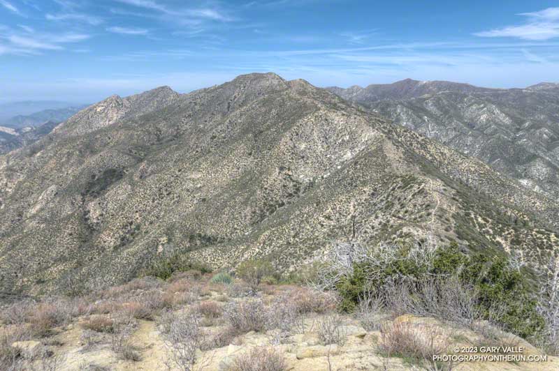
After climbing Condor Peak, I paused along the trail between the peak and Fox Mountain to take a photo. That’s when I heard a loud rattling behind me. I slowly turned around… A very upset snake was in the brush about 15 feet away and continuing to buzz.

Many rattlesnakes I encounter don’t rattle — even if directly on the trail. But for some reason this well-hidden snake was really agitated.

Josephine Peak and Strawberry Peak from the Condor Peak Trail. (thumbnail)
Josephine Peak and Strawberry Peak

The rattle sounded like that of a mature snake. I briefly considered looking for it. But, I reasoned, if the snake had been kind enough to rattle, then I should return the favor and leave it alone. It was already amped and clearly knew where I was. While I was curious, I didn’t need to see THIS snake. I turned and continued down the trail.

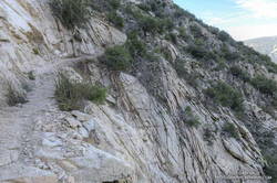
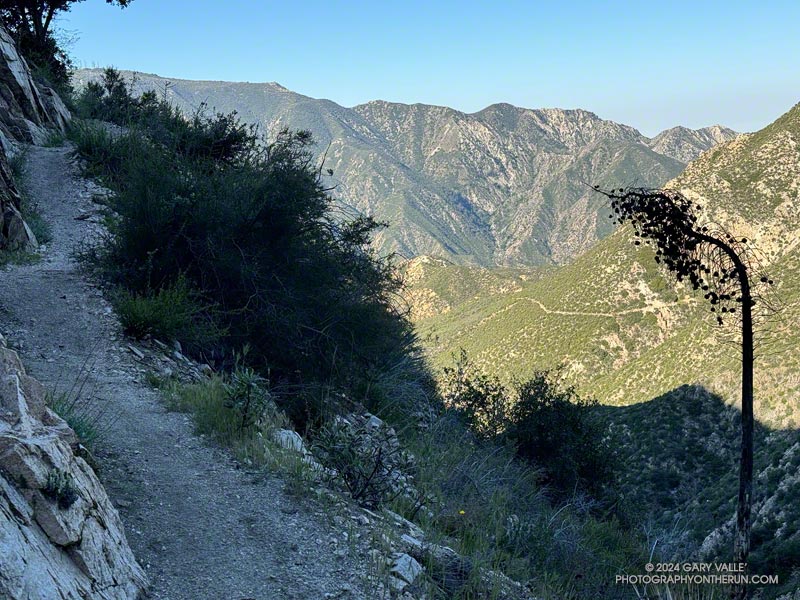
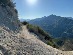
It had been one of those runs where everything goes as planned. Other than the first 50 yards or so of the Vogel Flat Trail — which was in terrible condition — it had been a nice change to be on a “normal” trail. By that, I mean a trail that (generally) wasn’t rutted, overgrown, or washed out. Consecutive wet rain seasons have been hard on lower elevation trails in the Los Angeles area.

The San Gabriel Mountains from East Condor Peak. (thumbnail)
The San Gabriels from East Condor Peak.

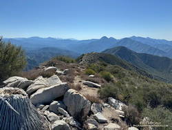
I was the first up to the peak, and on the way down passed several small groups of hikers. The topmost group was resting in the shade near Fox Mountain, and the others working up the trail farther down the mountain. All were enjoying the day.

According to the Tempe thermometer on my pack, the temperature climbed steadily from 60 degrees at the start of the run to around 75-80 degrees on Condor Peak. The day wasn’t forecast to be particularly hot — around 85 in the warmer valley locations. But on the return from Condor, the temperature in the sun in the south-facing bowl at the head of Fusier Canyon was in the 90s. This was offset somewhat by the shaded little streams in the corners of the canyon. In some years these have been completely dry.

Paintbrush mixed with bush poppy along the Condor Peak Trail. (thumbnail)
Paintbrush and bush poppy.

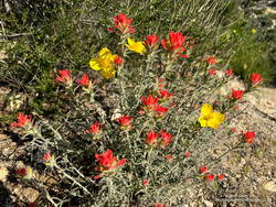
As elsewhere this Spring, the wildflowers along the trail were spectacular. Some of those in bloom included woolly paintbrush, yellow monkeyflower, chaparral whitethorn, hoary-leaved Ceanothus, bush poppy, collarless California poppy, chia, and black sage. The paintbrush and bush poppy were especially striking.

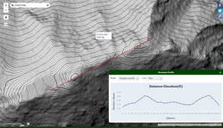
Here’s an interactive 3D-terrain map of my GPS track (yellow) of the route to Condor Peak, starting near Vogel Flat on Big Tujunga Canyon Road. It’s a strenuous 16-mile run, hike, or ride, with an elevation gain of about 4000′. The summit of Condor (either one) is at about 5441 feet.

Some related posts:
Condor Peak and Fox Mountain Adventure Run
Condor Peak Out and Back Adventure Run
Condor Peak Trail Run

Condor Peak and Fox Mountain Adventure Run

Condor Peak from Fox Mountain

The out and back trail run to Condor Peak (5440’+) and Fox Mountain (5033′) from Vogel Flat is an adventurous 17-mile, lower elevation run in the San Gabriel Mountains.

Exposed stretch of the Condor Peak Trail

When I last did this run (May 2020), portions of the trail below Fox Mountain were washed out and overgrown. Later I learned that this was before the Condor Trail restoration project had been completed. Thanks to the hard work of the Lowlifes Trail Crew the trail has been brought back to life. Today, several groups — including hikers, bikers, and runners — were making their way to Condor Peak.

Hazy view of snow on Mt. Waterman and Twin Peaks from the Condor Peak Trail.
Snow on Mt. Waterman and Twin Peaks from the Condor Peak Trail.

As mentioned in my posts from 2007 and 2020, this adventure is best done when the weather is cool. It can really bake on the south-facing sections of trail. From the Vogel Flat Trailhead on Big Tujunga Canyon Road the trail climbs about 2600′ in 6 miles to reach Fox Divide. Much of this stretch is surprisingly runnable. As with most mountain trails, extra care is required because of steep drop-offs and other hazards.

Today, the trail was in the best shape I’ve seen in years. The weather was relatively cool and good for running. As has been the case in other low elevation areas, a colorful assortment of Spring wildflowers were blooming along the trail. With our copious Winter rain, two small streams were crossed on the traverse above Fusier Canyon. It’s hard to say how long they will last.

USGS Lidar-based 3DEP 1m contour map of Condor Peak

Condor Peak has twin summits. A register and summit sign currently reside on the west peak, but USGS 3DEP 1-meter Lidar-based data suggests the west and east peaks have virtually identical elevations – about 5441′.

This time, after climbing Condor Peak, I also climbed Fox Mountain. Although steep, it’s short, and doing Fox only added about 30 minutes to the total time.

Here are a few photos taken along the way. Additional info, photos, and an interactive map with 3D terrain can be found in the following related posts.

Some relate posts: Condor Peak Out and Back Adventure Run, Condor Peak Trail Run