Category Archives: wildflowers

Spring Fever Running the Phantom Loop in Malibu Creek State Park

Coast live oak along the Talepop Trail. Photography by Gary Valle'

One of the e-mountain bikers commented, “That’s a lot of water!”

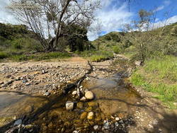
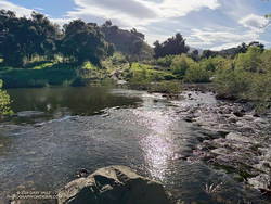
The three of us had arrived at the bank of Malibu Creek at the same time. There was a lot of water. The crossing must have been a real monster during some of this year’s storms, but this morning the creek was slow-moving and maybe 30-40 yards across. The main concern getting across would be slipping on the algae-covered rocks along the bottom and taking an unintended bath. I waded in.

Crags Road Trail crossing of Malibu Creek - March 2024 (thumbnail)
Malibu Creek – the trail continues on the other side.

How did I find myself wading across Malibu Creek on this brisk March morning? I was doing a convoluted variation of the Phantom Loop, enjoying the Spring scenery, and going where the trails and terrain took me.

What is the Phantom loop? For me, it’s any loop that starts at the Cistern Trailhead on Mulholland Highway and ends at the Phantom Trailhead on the other side of the highway. Or vice versa. And since it’s a loop, it could start/end at any trailhead on or near the loop.

There are many ways to complete this loop. Here’s an interactive 3D-terrain view of the shortest version I’ve done (7.3 miles), and here is a longer variation (24 miles).

Rising sun on the Lake Vista Trail in Malibu Creek State Park. (thumbnail)
Lake Vista Trail

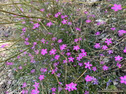
My run started on the Cistern Trail shortly after dawn. I’d run through Reagan Ranch and then up the Lake Vista Trail to the overlook for an early morning view of Malibou Lake. From the overlook, I’d continued east on the Lake Vista and Deer Leg Trails, enjoying the blooms of the Ceanothus, Hummingbird Sage, and bush poppy along the way.

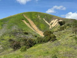
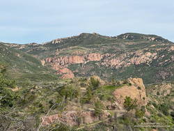
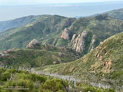
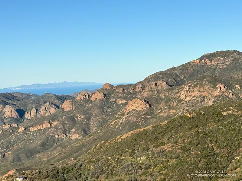
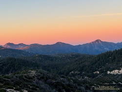
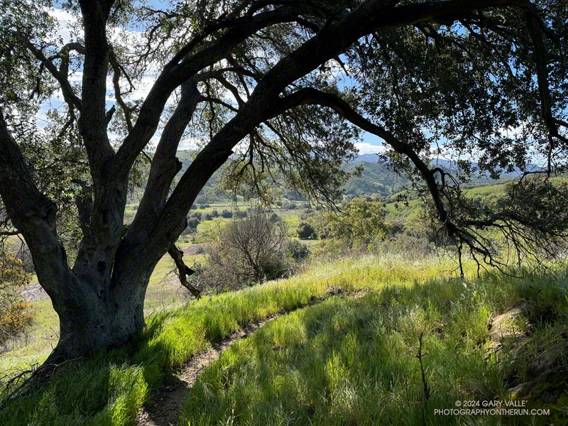
Just before the Deer Leg Trail descends from the crest, I stopped at another overlook to take in Malibu Creek’s stunning terrain. From the viewpoint, I could see the coast redwoods along Century Lake. A few of the tall trees survived the 2011-205 drought and the 2018 Woolsey Fire, including one young naturally germinated tree. Now we’re in a rare wet cycle. The past two years are among the wettest on record for Los Angeles — good news for the remaining trees!

From the overlook of Malibu Creek, I ran down to the Yearling Trail, turned right (east), and in about a hundred yards was at the top of the Cage Creek Trail. I followed this short trail down to Crags Road and Malibu Creek.

Improvised bridge across Malibu Creek. (thumbnail)
Runner crossing a makeshift bridge across Malibu Creek.

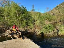
I thought there was a chance the seasonal bridge on the way to the M*A*S*H site might have already been reinstalled. It hadn’t, but a pile of limbs and logs spanned the gap across the creek.

From the matchstick bridge, I turned around and ran east on Crags Road, past the Cage Creek Trail and Century Lake, and then down the road to the junction of High Road and Crags Road.

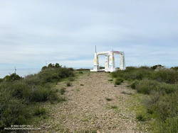
When doing the Phantom Loop, I usually continue east under the oaks on High Road to the Grassland Trail. But this morning, in keeping with today’s theme, I headed across the bridge — in the direction of the Visitor Center — and looked for a sign marking the start of the Chaparral Trail.

Goat Buttes and Planet of the Apes Wall from the Chaparral Trail. (thumbnail)
Goat Buttes and Planet of the Apes Wall from the Chaparral Trail.

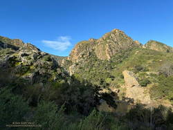
Only about a half-mile long, this obscure trail starts about 60-70 yards northeast of the Visitor Center and links to Mott Road/Century Mtwy, near Crags Road. It has unique views of Planet of the Apes Wall, Malibu Creek, and Goat Buttes. When I reached the trail’s end, I turned left on the road and followed it to the flooded crossing on Crags Road.

Wading into a stream is always a bit awkward. I decided to follow a rocky shoal where the water was about calf deep. As expected, the rocks were rounded and slimy. I didn’t have poles and the footing wasn’t the best, but I managed to get across without incident.

In a few steps, I was headed east and back on the route of the “standard” Phantom Loop. In about a tenth of a mile, I forked left off the main road and onto the Grasslands Trail.

I’m always surprised how quickly the squishiness of wet running shoes and socks goes away. (Today, I was running in Hoka Challenger ATR 7s with Injinji socks.) By the time I reached Mulholland Highway, my shoes and socks had air-dried and felt more or less normal. Crossing Mulholland Highway, I walked east a few yards and continued north on the North Grasslands Trail to the Liberty Canyon Trail.

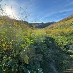
I hadn’t run far in Liberty Canyon when I came to the Talepop Trail. It had been a long time since I had done the Talepop – Grasslands (Las Virgenes Fire Road) Loop. The hills were green, the sun shining, and the temperature perfect for running. What better time than now to get on it again? With the cool conditions, I had plenty of water to do the extra three to four miles and wouldn’t have to make a side trip to De Anza Park.

Las Virgenes Fire Road Trail (thumbnail)
Las Virgenes Trai/Fire Road

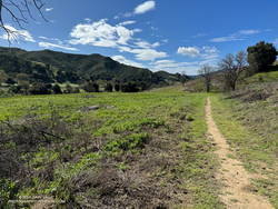
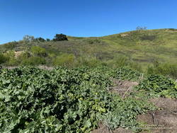
The loop was as pretty as I remembered it. Initially following an undulating ridge, the Talepop Trail eventually winds down to the grassy valley to the east and intersects Las Virgenes Fire Road. A left (north) turn here goes to De Anza Park; a right turn traverses classic oak grassland and leads back to the southern end of the Liberty Canyon Trail.

After completing the Talepop Grasslands loop, the remainder of the run followed the usual route of the Phantom Loop. It continues about 1.5 miles north on the Liberty Canyon Trail, but before reaching the trailhead, it jogs left (west), goes over Liberty Creek, and around to a short trail that connects to the Phantom Trail at a group of eucalyptus trees. My route in this area can be viewed by using our high-resolution, interactive 3D viewer and zooming in on the area near the Liberty Canyon Trailhead.

Hillside covered in wildflowers in Malibu Creek State Park
Hillside covered in wildflowers

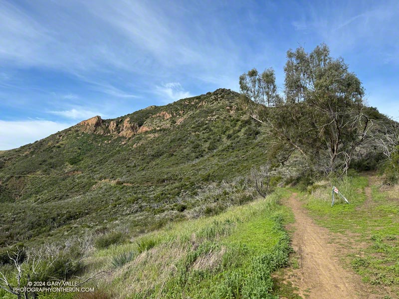
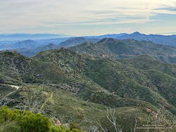
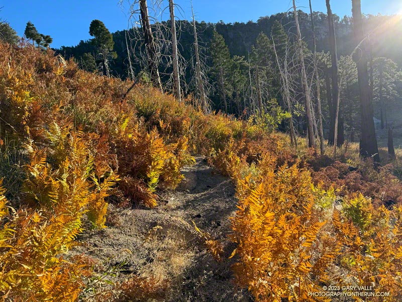
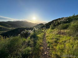
The Phantom Trail goes west up a canyon and then turns south, eventually reaching Mulholland Highway near the Cistern Trailhead. Once out of the canyon, the main trail crosses a use trail several times, so care must be taken to stay on route. The use trail more or less follows the ups and downs on the crest of the ridge, while the main trail switches from one side of the ridge to the other, avoiding unnecessary elevation gains.

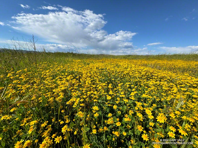
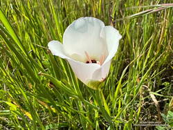
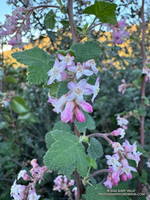
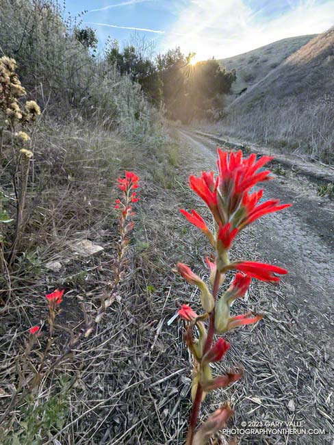
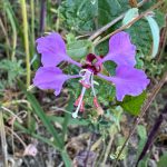
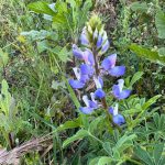
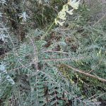
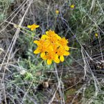
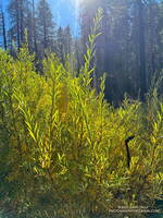
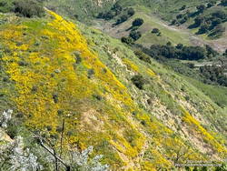
The last time I ran this segment of trail — October 2023 — it was VERY overgrown (video). This time, thanks to the work of SMMTC volunteers, nearly all of the trail had been cleared. Many colorful wildflowers were in bloom on this stretch, including Ceanothus, Encelia, Wishbone bush, California poppy, owl’s clover, and paintbrush.

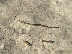
Here are a few photos (and notes) from the trail run, including some of the wildflowers seen along the trail.

Some related posts:
Bulldog Loop Plus the Phantom Loop
Redwoods, Raptors, and the Phantom Loop
Malibu Creek State Park Scenic Loop

Goldfields, Silt Slides, Oak Leaves, Invasive Thistle, Rough Trails, and a Reminder to be Watchful

Goldfields blooming on Lasky Mesa - March 2024
Goldfields blooming on Lasky Mesa

Following are some notes and photos from runs in Upper Las Virgenes Canyon Open Space Preserve (Ahmanson Ranch) during March 2024.  Spring is here! The hills are green, goldfields and other wildflowers are blooming, and Las Virgenes Creek is flowing.

Goldfields and Other Wildflowers

The first goldfields (Lasthenia gracilis) of 2024 began to bloom on Lasky Mesa at the end of February. Now, bright yellow patches of these “belly” flowers are scattered across the mesa, adding a brush of color to the roads and trails of Ahmanson Ranch. The cheery flowers usually disappear with the first spell of hot and dry weather. Looking ahead, more rain and cool weather are forecast Easter weekend, and extended temperature outlooks are mixed. Hopefully, the goldfields will be around for a few more weeks.

Catalina mariposa lily at Ahmanson Ranch. March 27, 2024. (thumbnail)
Catalina mariposa lily. Click to enlarge.

Some other wildflowers are also blooming. Blue Dicks usually flourish following a wet Winter, but this March are less widespread than usual. Red maids are also less numerous than normal and their flowers somewhat smaller. The elegant white flowers of Catalina mariposa lily are just starting to bloom.

Thanks to T.S. Hilary’s false Spring and copious Winter rain, the hills of Ahmanson Ranch have been green since early October.

Silt Slides
Slides of silty soil in Upper Las Virgenes Canyon Open Space Preserve (thumbnail)
New (left) and old slides of silty soil. Click to enlarge.

With all the rain, small, shallow mudslides have been common along road cuts and other steep slopes of Ahmanson Ranch. The area has fine-grained silty soil. When saturated, it can generate a slurry of silt and debris. The numerous scars on the hillsides suggest this is a primary mechanism of erosion in the area.

Valley Oaks

After losing their leaves in December, the Valley Oaks at Ahmanson are now budding and sprouting. Some trees already have new leaves, while others are still bare-limbed. The period valley oaks are without leaves varies from year to year depending on rainfall, temperature, sunshine, and other factors.

Invasive Milk Thistle
Milk thistle in Las Virgenes Canyon
Milk thistle. Click to enlarge.

Milk thistle thrives during wet years, and it’s been very wet. We’ve had two consecutive wet years, plus a tropical storm thrown in for good measure. The invasive is sprouting in areas where it doesn’t normally grow and growing prolifically in areas where it is established. In a few months, milk thistle may look like it did in May 2005, following the record 2004-2005 rain year.

Rough Trails
Upper Las Virgenes Creek (thumbnail)
Upper Las Virgenes Creek. Click to enlarge.

Profuse rainfall is a two-edged sword. It revitalizes the ecosystem, turns the hills green, recharges the creeks, preserves the trees, produces wildflowers and more. But it can also be problematic — triggering slides, washing out and damaging trails, and promoting plant growth that chokes trails and increases the fire hazard.

At the moment, the roads and trails at Ahmanson are a bit rougher than normal, particularly in East Las Virgenes Canyon. Use and drier weather will gradually smooth out the ruts and rugosities, but we’re going to be picking foxtails from our socks for some time to come.

Upper Las Virgenes Creek is still flowing — including in the canyon’s upper reaches. Sometimes, there will even be a log or two in place to help keep your shoes dry.

And A Reminder to be Watchful
Baby rattlesnake at Ahmanson Ranch (thumbnail)
Baby rattlesnake. Click to enlarge.

I sometimes stretch at the info kiosk at the Victory trailhead before running. Today, as I placed my hands against one of the kiosk posts and started to stretch, I glanced down. Disturbingly close to my feet was a small snake. Adrenaline flowing, I checked the head and tail and then checked them again. I stepped back and began to breathe. It was a gopher snake. But it could have just as easily been a rattlesnake. In fact, later on that run, I encountered a baby rattlesnake. That day and the next (March 20 and 21), I saw a total of four gopher snakes and two Southern Pacific rattlesnakes.

Some related posts:

Ahmanson Ranch  and Las Virgenes Creek After Six Days of Rain
East Las Virgenes Canyon After a Seventh Day of Rain
A Second Spring at Ahmanson Ranch
Looking For Local Impacts of Tropical Storm Hilary

Backbone Trail Run: Encinal Canyon to Triunfo Peak

A eucalyptus tree marks the Triunfo Peak Access trail on the Yerba Buena segment of the Backbone Trail
The Triunfo Peak Access trail forks off the Backbone Trail at a prominent eucalyptus tree.

Following more wet weather, I was back on the Backbone Trail and running in the direction of Mishe Mokwa from the Encinal Canyon trailhead. But this time, instead of going to Mishe Mokwa, I planned to do an out-and-back run to Triunfo Peak (2658′).

Echo Cliffs from Yellow Hill Fire Road on Triunfo Peak (thumbnail).
Echo Cliffs from Yellow Hill Fire Road on Triunfo Peak. Click to enlarge.

Whenever I’ve been on the Yerba Buena segment of the Backbone Trail, I’ve been curious about this peak. Situated on the crest of the Santa Monica Mountains, east of Sandstone Peak, it seemed like it might be an outstanding viewpoint, and I wasn’t disappointed.

About a half-mile up the Backbone Trail from the Encinal Canyon trailhead, I was surprised to be able to get a glimpse of the peak. Historic topo maps labeled the fire lookout on Triunfo Peak as “Triunfo Lookout” and now the peak is often referred to by that name.

Rock formations near the Grotto from Triunfo Peak (thumbnail).
Rock formations near the Grotto. Click to enlarge.

It was another beautiful morning on the Backbone Trail. A chilly 39 degrees at the trailhead, it warmed quickly as I ran up the trail toward Mulholland Highway and then Etz Meloy Mtwy fire road. The bloom of bigpod Ceanothus was in full swing, and the lilac blooms of hairy-leaved Ceanothus were already following suit.

Thin high clouds veiled the sun and muted the scene as I descended the Backbone Trail to Yerba Buena Road. To the west Triunfo Peak/Lookout, Boney Mountain, and Sandstone Peak filled the skyline, their rocky prominences inviting further exploration.

Summit of Triunfo Peak (thumbnail).
Summit of Triunfo Peak. Click to enlarge.

About two miles west of the Yerba Buena Road, a makeshift sign indicated where the trail to the peak could be accessed. In 40-50 yards the side trail led to Yellow Hill Fire Road — the old lookout service road. It had recently been cleared of brush. From the sign on the Backbone Trail, it was about three-quarters of a mile to the top of the Triunfo Peak, with an elevation gain of about 380 feet.

According to the Former Fire Lookout Sites Register and Fire Lookouts websites, the lookout on Triunfo Peak was established in the early 1930s and taken out of service in the late 1960s. A steel lookout tower originally on Blue Ridge in Angeles National Forest was first moved to Bodle Peak around 1930, then moved and reassembled on Triunfo Peak in 1935.

View east from Triunfo Peak along the crest of the Santa Monica Mountains (thumbnail).
View east from Triunfo Peak along the crest of the Santa Monica Mountains. Click to enlarge.

The photograph of the lookout tower when it was on Blue Ridge suggests the shrine-like concrete structure found on the summit of Triunfo Peak is the footing for the tower. Google Earth imagery shows a similarly-sized footing on Bodle Peak -— a square a little larger than eight feet on a side. The tower is  described  as having an “8×8 observation cabin.”

A short connector trail is being constructed on the wet/northwest side of Trunfo Peak. When the trail is complete, it will connect the Backbone Trail to Yellow Hill Fire Road, near the summit of Triunfo Peak. The new trail will enable those doing the Backbone Trail to climb Triunfo Peak and return to the Backbone Trail without backtracking.

Related post: Rainy Season Trail Running on the Backbone Trail

Rainy Season Trail Running on the Backbone Trail

Rock formations below Triunfo Lookout, with the Channel Islands in the distance. From the Etz Meloy section of the Backbone Trail.
The Backbone Trail contours around Triunfo Peak (on the right) above the rock band that extends across the photo. The Channel Islands are in the distance.

The Backbone Trail between Encinal Canyon and Mishe Mokwa is one of the must-do sections of the 68-mile trail. Engineered to be multi-use, this exceptionally scenic stretch of the Backbone Trail is popular with riders, hikers, and runners alike.

Chaparral Currant (Ribes malvaceum) blooming along the Backbone Trail (Thumbnail)
Chaparral Currant

It’s also a pretty good place for a trail run after rainy weather like we’ve had this February. Although the parking lot at the Encinal Trailhead was quite wet this morning, the  Backbone Trail was in decent shape most of the way to the Mishe Mokwa trailhead. There were a few muddy and wet spots, but it was generally easy to work around them. And I didn’t have to change my shoes before driving home.

The out & back run worked out to about 21-miles, with a surprisingly moderate gain/loss of about 2500′. The weather and visibility were excellent. Striking rock formations and the Channel Islands could be seen from one side of Etz Meloy Mtwy fire road, and snow on Alamo Mountain and other Ventura County peaks from the other side.

On the way back, as I was working up the long hill on the northwest side of Triunfo Lookout, a descending mountain biker commented that a large group of bikers were at “the corner.” The overlook at this prominent switchback has a wide-ranging view of Mishe Mokwa, Boney Mountain, and Sandstone Peak, and some prefer to turn around here. This variation is about 3.5 miles shorter (round-trip) than dropping down into the canyon and going all the way to Mishe Mokwa.

Explore the scenery and terrain on the Backbone Trail of this out-and-back trail run and hike from Encinal Canyon to Mishe Mokwa using our high resolution,  interactive, 3D viewer. The imagery is so detailed, it’s almost like being there! To change the view, use the control on the upper right side of the screen, the CTRL key and your mouse, or touch gestures. Track and placename locations are approximate and subject to errors. Poor weather, and other conditions may make this route unsuitable for this activity. Here’s  an elevation profile of the route.

Some related posts:
Encinal Canyon to Mishe Mokwa Out and Back Trail Run
Kanan to Mishe Mokwa and Back
Kanan to Mishe Mokwa to Wendy Drive
Night Training for the Backbone Ultra

Spring Wildflowers in December?

Paintbrush blooming in mid-December in Cheeseboro Canyon in Southern California near Los Angeles
Paintbrush blooming in mid-December in Cheeseboro Canyon

The paintbrush above, and the following Spring-blooming wildflowers were photographed on December 14,2023, on a trail run from the Victory Trailhead of Upper Las Virgenes Canyon Open Space Preserve. With the exception of the black mustard, the wildflowers were found along a half-mile stretch of dirt road connecting upper Las Virgenes and Cheeseboro Canyons.

The false Spring was the result of rain from Tropical Storm Hilary in August, an extended period of wetter than normal weather, and somewhat warmer Fall temperatures. The Water Year that ended September 30, 2023 was the seventh wettest on record for Los Angeles and Calendar Year 2023 was the sixth wettest.

Some related posts:
– A Second Spring at Ahmanson Ranch
– Seventh Wettest Water Year in Los Angeles Results in Rarely Seen Trail Conditions
– Looking For Local Impacts of Tropical Storm Hilary


Three Points Loop Following the Reopening of Angeles Crest Highway

Bracken fern turning color at Waterman Meadow is a sure sign of Autumn.
Waterman Meadow

I was beginning to wonder if I would get a chance to do the Three Points Loop around Mt. Waterman this year. Angeles Crest Highway had been closed from Red Box to Vincent Gap for many months, and CalTrans projected it might not open until Thanksgiving.

That’s why Friday (November 3) I was excited to hear Angeles Crest Highway had reopened between Upper Big Tujunga Rd. and Islip Saddle.

Alpenglow on the San Gabriels' Front Range peaks.
Alpenglow on the San Gabriels’ Front Range peaks.

At dawn, a couple days later, I pulled into the Three Points parking lot, put on some sunscreen, grabbed my pack, and set out to see what was happening on the Three Points loop around Mt. Waterman.

I’d done the loop many times and in many situations — clockwise, counterclockwise, after the Station Fire closure, after the Bobcat Fire closure, with snow at the higher elevations, in hot weather and in cold. When the trails are in good shape and the weather isn’t too hot, the 20-mile loop is an outstanding trail run. Today, it was a challenge just to complete the loop.

Gilia along the Burkhart Trail. November 2023.
Gilia along the Burkhart Trail.

In many areas of Southern California, a wet 2022-2023 rainy season and Tropical Storm Hilary’s rain produced two seasons of Spring-like growth. One of the effects of the rain was the growth of wildflowers usually seen in the Spring, including seep monkeyflower, golden yarrow, gilia, grape soda lupine, and little paintbrush. It was strange to see a bumblebee buzzing from flower to flower of a Grinnell’s penstemon at 7250′ on Mt. Waterman in November.

At lower elevation, sections of Three Points – Mt. Waterman Trail (10W04) were overgrown with mountain whitethorn — requiring several “grin and bear it” passages. Higher, long stretches of the little-used path were covered with a second season of grass. This made route-finding difficult, particularly where the trail descends to the Twin Peaks Trail junction.

Twin Peaks from the Buckhorn - Mt. Waterman Trail.
Twin Peaks from the Buckhorn – Mt. Waterman Trail.

It was an intriguing puzzle to solve, and eventually I made it to the junction of the summit trail and the trail down to Angeles Crest Highway, near Buckhorn (10W05). The trail down to Buckhorn sees much more use than the trail from Three Points and is much better defined. Besides a couple of downed trees, the run down was one of the more enjoyable parts of the loop. The trail is usually very busy, but I didn’t encounter anyone coming up the trail.

As expected, Buckhorn Campground was closed and no water was available. It was a warm day — around 75 degrees — but with the November sun low in the sky, not as warm as 75 degrees in July. If I needed more water, there were several places I could refill.

Cooper Canyon Falls, November 2023.
Cooper Canyon Falls (video)

The Burkhart Trail (below Buckhorn) was the only place I encountered a few hikers. They were returning from Cooper Canyon Falls. When I got down to the PCT and saw how much water was in the creek, I did the short side trip to the falls and took this video snapshot. It’s unusual for the falls to be flowing this time of year.

After checking out the falls, I resumed my westward journey on the PCT. Within feet of the creek crossing, an ugly tangle of fallen trees completely blocked the trail. This was just the first of several problems on the PCT between the Burkhart Trail junction and Cooper Canyon Camp. There were the usual downed trees, but there were also several sections of badly overgrown trail. These green thickets were generally adjacent to the creek, where the trail had been (or still was) wet.

Willows along the creek near Cooper Canyon Trail Camp.

Needing water, and to empty the debris from my shoes, I stopped for a few minutes at Cooper Canyon Trail Camp. Several campsites are nestled in a pleasant area along the creek. With Angeles Crest Highway open, I thought I might see someone here, but like Buckhorn Campground, it was empty.

After reaching Cloudburst Summit, the remainder of the run was more or less usual for the loop. There was some Poodle-dog bush and a small rockslide along the PCT on the way to Camp Glenwood, but neither were an issue. The run was more challenging than usual — and a bit slower — but it had been (mostly) fun and fascinating to work through it.

Here are a few photos taken along the way.

Some related posts:
After the Bobcat and Station Fires: Three Points Loop Around Mt. Waterman (Slideshow, 3D Terrain Maps)
Cool Weather, Old Trees, Grape Soda Lupine and a Restored Trail
Lemon Lilies, Tree Rings and More Heat Training on the Three Points Loop
Three Points Loop Adventure – July 2020