
After so many years of doing the Angeles National Forest Trail Race, I’m not sure I even had a choice. At about 7:00 a.m. on Saturday, July 11, 2020, I found myself running down Mt. Wilson Road.
It was odd not to be surrounded by runners. Gary Hilliard had not done his one-of-a-kind pre-race briefing. There had been no hugs or handshakes at the start of the run. No runners commented on the temperature or talked about past or future races. Thanks to COVID-19, the 2020 ANFTR race had been canceled.
But the mountains and trails were still there, and by running the 25K course, I could get a good idea of what the 2020 race might have been like.
I was not racing the course. The forecast was — of course — for a hot day. And in these covid times, I was running solo. I was out to enjoy “being there” — seeing what I could see, learning what I could learn.
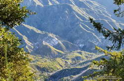
Mt. Wilson road is exceptionally scenic, and on the way down to Eaton Saddle, I stopped several times to take photos. The canyon of the West Fork San Gabriel River is spectacular. It’s a long way down to the bottom, and I always marvel at its depth. The 2600′ climb out of that canyon is the crux of all the ANFTR courses, and as I would later discover, would be especially challenging today.
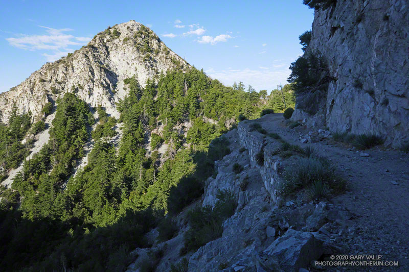
Rugged San Gabriel Peak marked the turn onto Mt. Lowe fire road at Eaton Saddle. From here, the course follows the fire road through Mueller Tunnel and up to the saddle between Mt. Markham and San Gabriel Peak. The first significant climb of the course begins here. Much of the 650′ climb up the single-track trail is in the shade. If it’s already warm here…
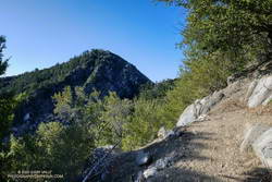
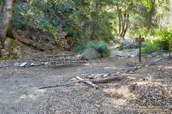
The single-track trail leads up to the Mt. Disappointment service road. The high point of the 60K, 50K and 25K courses — about 5780′ — is along this short stretch of road. For the 25K course it’s (almost) all downhill from here to West Fork. A winding, and usually dusty, single-track trail turns off the service road and leads down through scrub oaks to Mt. Wilson Road, just above Red Box.
In the actual event, runners doing the 50K and 60K turn left onto the Gabrielino Trail at Red Box and do a 15+ mile circuit around Strawberry Peak. Runners doing the 25K turn right and continue down Rincon – Red Box Road to West Fork.
The time of day when you do the 5+ mile segment from Red Box to West Fork makes a huge difference. On hot race days, such as in 2012, 2017 and 2018, the road bakes and in-the-sun temps can reach well over 100 degrees. (This isn’t the only part of the 50K/60K course that can be hot!)
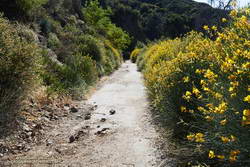
Because I was running the 25K course, I was on Red Box road relatively early. It was probably in the 90s in the direct sun, but there were still some cool stretches of shade. In years with average or above-average rainfall, there are usually a few little stream crossings where capfuls of water can be dumped on your head. They were flowing today. Usually at West Fork there is a hose/shower setup to use for cooling.
There was no shower setup at West Fork this morning, but the water flowing from the spring was clear and cold. I filled my Camelbak to the brim and then gulped some more. I felt good and thought I might try to push the pace a bit going up to Wilson.
There was a collapsed sycamore on the trail near the spring, but it didn’t look like it was going to be much of a problem. On the run down to West Fork, I’d noticed an increasing number of trees on the road. About a mile from West Fork, a large oak had fallen down a road-cut, blocking the road and bringing with it a pile of debris.
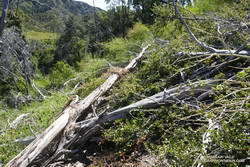
Leaving West Fork on the Gabrielino Trail, I worked around the fallen sycamore and then continued up the trail. Within yards there was another fallen tree, then another, and another. The number of trees down on the trail was remarkable. Part of the reason is that the Forest Service isn’t currently allowing volunteer groups to do trail maintenance. I’m sure ANFTR R.D. / AC100 Trail Boss Gary Hilliard is going crazy not being able to work on the trails.
But I think there’s more to it than trail maintenance. There are far more trees down on the trail than I’ve seen in other years. The area is covered in scrub oaks and bay trees that were killed by the Station Fire. I suspect the same storms that broke and toppled trees in the San Gabriels high country over the Winter, toppled dead trees here as well.
It became a mantra — over, under, around or through? Over, under, around or through? Tree after tree. It was warming up, and the extra work of battling the trees added to the effort. On the Gabrielino segment of the route, trail users had trimmed some small limbs from a few of the trees, and that helped.
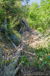
I thought that once I got out of the scrub oaks and into the forest proper, there wouldn’t be so many trees on the trail. That was mostly true, but there were still several tree challenges higher on the Kenyon Devore Trail. One large log was perched across the trail at the top of a steep gully. I didn’t want to slip and started to use the log for hand-holds. Bad idea! Who knew how little force would be required to dislodge the tree.
Eventually, I reached a point on the trail where I could just hike and didn’t have to climb over, under, around or through anything. What a relief!
It’s difficult to estimate just how many trees were down on the trail. Fifty? Sixty? I have no idea. There were many small trees I didn’t even think about, and there were multiple trees down in some spots. However many there are, if another Winter passes before the trails can be maintained, it will require a massive effort to get them cleared.
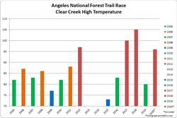
Based on the temperatures recorded at the Clear Creek RAWS, this would have been the #3 or #4 hottest of the ANF Trail Races. Compared to the other hot races, temps were a few degrees cooler early, but reached similar temperatures by mid-afternoon. The Clear Creek RAWS recorded hourly temperatures as high as 96°F and hourly fuel temps as high as 121°F.
See the ANFTR web site, Facebook page and Facebook group for more info. All the results for the ANFTR/Mt. Disappointment races since 2005 can be found on Ultrasignup.com.
Some related posts: ANFTR/Mt. Disappointment 2019, Another Scorching Angeles National Forest/Mt. Disappointment Trail Race, Record Heat for the 2017 Mt. Disappointment 50K & 25K