Category Archives: nature|weather

Snow on Oat Mountain

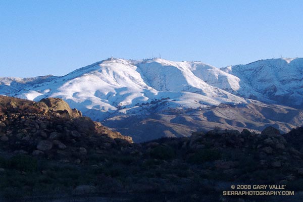
Snow on Oat Mountain. December 18, 2008.
Snow on Oat Mountain – December 18, 2008.

Our latest storm added another half-inch of rain to our water year total in Los Angeles. This brings the water year rainfall total to 2.85 inches. This is 1.35 inches above normal for the date. As much as a foot of snow was reported in the Antelope Valley and the snow level dropped to nearly 2000 ft in the foothills and mountains of Ventura and Los Angeles counties.

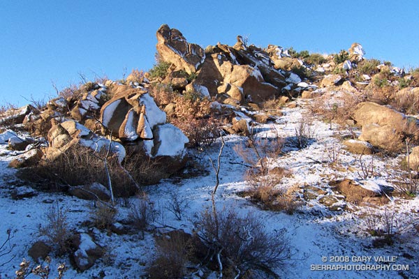
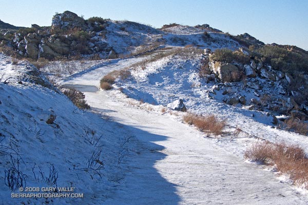
Snow on Rocky Peak fire road.
Snow on Rocky Peak fire road. December 2008

What’s next? Things should stay dry in Southern California until around Monday when a fast-moving front sweeps through the state. Later in the week, sometime around Christmas, the models are suggesting the possibility of a major system impacting California. We’ll see!

The photograph of Oat Mountain was taken this morning on an out and back run on Rocky Peak fire road. The highest stretches of the fire road were covered with an icy layer of snow.

Related post: Chumash Trail Rocks & Snow

Clearing Clouds from Sage Ranch

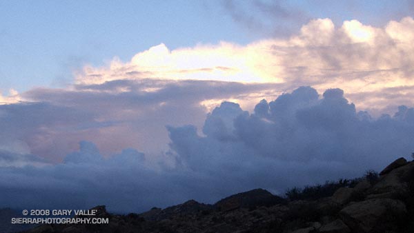
Clearing clouds, northwest of Los Angeles, following the passage of an upper low storm system that resulted in widespread rainfall in Southern California.

Clearing clouds, northwest of Los Angeles, following the passage of an upper low storm system that resulted in widespread rainfall in Southern California. Several rainfall records for November 26 were broken in Los Angeles County.

Update 12/5/08 P.M. High amplitude flow continues to wreak havoc with forecasts. Our on-again, off-again chance of a shower this weekend might be on again. Original cut-off upper low center is still well offshore, but another low center has developed on the downstream side of high amplitude ridge, and this one is much closer to the Southern California coast. The low appears to be entraining some moisture, and could produce some showers, particularly as the low moves onshore and is absorbed in the main flow. We’ll see!

Update 12/5/08 A.M. No rain is expected in SoCal this weekend… The cut-off upper low set up much further west than suggested by models Tuesday and now is spinning out in the eastern Pacific, nearly halfway to Hawaii. At the moment, it looks like it could be mid-month before our next chance for significant rain.

Update 12/2/08. Computer models have been having a tough time with both the short and medium term forecasts for Southern California. Recent runs have been hinting at the possibility of some rain Saturday or Sunday. This would depend on the strength, position and behavior of an upper low that is forecast to form off the Southern California coast Thursday.

From a run at Sage Ranch Park, near Simi Valley, California.

T-storms and Trail Work

Old Boney Trail in the Boney Mountain Wilderness

When I woke to the rumble of thunder, rain pounding the roof, and wind roaring in the trees, I wondered if a planned run of the Boney Mountain Half Marathon course with John Dale was going to turn into an epic. Radar and satellite imagery showed subtropical moisture streaming in from the southwest, producing bands of showers and thunderstorms. Things don’t always look as bad at the trailhead as they do on weather radar, so I grabbed my gear and headed for Wendy Drive.

The weather looked promising driving through Agoura, but the further west I drove, the more ominous the skies became. Somewhere around Lynn Road KNX announced that the NWS had issued a severe thunderstorm warning for the Santa Clarita area, with cloud to ground lightning, heavy rain, possible damaging winds and dime-sized hail. It was with that thought in mind, and a shower pelting the car, that I pulled into the parking area on Potrero Rd.

If anything, weather is fickle, and sometimes that quirkiness can work for you. There was an area of heavy rain to the west, but the activity appeared to be skirting the area, so we opted to start the run.
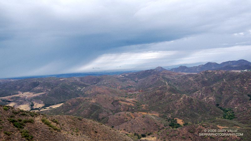

Thunderstorm marching northeast from the Santa Barbara Channel across the Oxnard Plain.
There were a few sprinkles as we jogged down the blacktop into Big Sycamore Canyon, and a few more as we did the first easy mile of the Hidden Pond Trail. Down in the canyon it was hard to tell what the weather was doing, but after gaining some elevation we reached a better vantage point. Just a few miles away thunderstorms were being swept northeast from the Santa Barbara Channel, across the Oxnard Plain, and into the Ventura Mountains.

Skies darkened and the shower intensity increased as we ran down Ranch Center Fire Road. The wind was blowing in the fitful gusts that precede a thunderstorm, and it felt as if the sky might fall at any moment. With a slight shift in the track of the thunderstorms we might be running in a deluge, dodging lightning strikes.

But it didn’t shift. Following the shower, the sun broke through the clouds just long enough to add glints to the raindrops dripping from the leaves of sycamores and oaks in Blue Canyon. Under overcast skies, we climbed up the Old Boney Trail and into the Boney Mountain Wilderness.

We had not seen a hiker, runner, or rider since turning onto the Hidden Pond Trail early in the run. So it was a bit of a surprise when we rounded a corner and ran into Ed Reid and several other volunteers with the Santa Monica Mountains Trails Council doing trail maintenance on a section of the Old Boney Trail.

Just about any weekend of the year, dedicated members of the SMMTC will be somewhere in the Santa Monica Mountains, working on a trail. To get a better idea of the amount of work done and the number of trails involved, take a look at this list of recently maintained trails! How many of these have you hiked, run or ridden?

There are several ways to help support SMMTC:

  • Volunteer to do trail maintenance.
  • Join the SMMTC.
  • Make your REI purchases using the REI link on the SMMTC web site. REI will donate a percentage of the purchase to SMMTC.

See the Santa Monica Mountains Trails Council web site for more info.

Some related posts: Boney Mountain Half Marathon, Return to Hidden Pond
Southern California 2008-2009 Winter Precipitation Outlook

Downtown Los Angeles (USC) happened to be under the right cloud yesterday, and recorded 0.02 inch of rain. There’s a continuing chance of showers in Southern California through the weekend. The area could use some rain. The last storm to produce more than a couple tenths of inch of rain at Downtown Los Angeles was back on February 24, 2008 — more than eight months ago.

Last year, California’s rain season might have been scripted by Dr. Jekyll and Mr. Hyde. Lowland rain totals and the Sierra snowpack were well above normal through the end of February, and then the spigot was turned off. The storm track shifted north, and California had its driest March to May on record. (The March 29, 2008 post in Ed Berry’s Atmospheric Insights blog describes the events that may have led to and maintained this shift.)

Which rain season personality will surface this Winter? Earlier this year the equatorial Pacific tried to transition to El Nino, but the atmosphere didn’t cooperate. As measured by the Multivariate ENSO Index (MEI), the ENSO state has returned to the weak La Nina threshold. And as measured by the Global Wind Oscillation (GWO), an uncooperative atmosphere has continued to cycle through a La Nina base state.

This suggests a winter precipitation outlook with a La Nina flavor — similar to last year. This precipitation map, generated by the ESRL-PSD Composite ENSO plots page, shows the mean November-March precipitation for the U.S. during 9 La Niña events from 1948 to the present. The average La Niña rainfall indicated for coastal Southern California is in the 7.0-10.5 inch range. Last season’s November-March rainfall in Downtown Los Angeles was about 12 inches.

Here’s the current Nov-Dec-Jan precipitation outlook issued October 16 by the Climate Prediction Center. The “EC” means an equal chance of below normal, near normal, or above normal precipitation. The IRI Multi Model Seasonal Forecast for Nov-Dec-Jan is similar. We’ll see what we get!

Three Points Loop Plus Mt. Waterman

If you spend much time in the mountains, sooner or later you’re going to get caught in a severe thunderstorm. I don’t mean you’re going to hear a little thunder and get a little wet. I mean you’re going to find yourself in the middle of a heart-pounding, ear-splitting, ozone-smelling, sense-numbing storm that drenches you through and through and wrings the nerves from your body.

Having been caught in such thunderstorms while climbing in Yosemite, running in the San Gabriels, and running at Mt. Pinos, I do my best to avoid the beasts. Sometimes, it is not an easy thing to do.

Take this weekend for example. I have a 50K race coming up, and in addition to increasing my weekday mileage, I needed to do a Sunday run of about 20-25 miles — preferably in the mountains.

The Sierra was out. A monsoon pattern virtually assured widespread, and possibly severe, thunderstorms. Some forecast models were saying that the focus on Sunday might be the Ventura County mountains, so Mt. Pinos — the site of my most recent thunderstorm adventure — was also out. Both San Gorgonio and San Jacinto had been hit pretty hard on Saturday. That left the San Gabriels, and thunderstorm activity was expected there as well.

The choices were A — get up really early and try to beat the heat and humidity and run local; or B — get up really early and try to get in a mountain run before the weather OD’d…

Running up the Mt. Waterman Trail, one of my ever-optimistic running partners voiced, “Hey, have you heard about the unusual number of lightning deaths recently?” So far it had been a spectacular day. A broken layer of mid-level clouds — remnants of yesterday’s storms — shrouded the sky. By keeping things a little cooler, the clouds had delayed the development of today’s thunderstorms.

We had started at Three Points and run up the Pacific Crest Trail to Cloudburst Summit, then down into Cooper Canyon, where we left the PCT and ascended the Burkhart Trail to Buckhorn Campground. In Cooper Canyon it was obvious there had been heavy rain the day before. Everything was wet, and the willows and lupines along the creek glistened in the muted morning sun. Rivulets of rainwater had incised rills in the trail, pushing pine needles and other debris into patterned waves.

I had already lost the “when it would start raining” bet. I had said 11:00. It was 11:00 now, and still there was very little cloud development. So little in fact, we decided to do a quick side trip to Mt. Waterman (8038′), and jokes were being made about the rain gear in my pack. (My GoLite 3 oz shell made a huge difference in the severe thunderstorm on Mt. Pinos.)

About the time we summited Waterman, things started to cook. The canopy of protective clouds was beginning to thin and dissipate and some cumulus cells were starting to build. I wondered if we would make it back to the car before it dumped.

We didn’t. About 30 minutes later, as we worked down the back side of Mt. Waterman toward the junction with the Twin Peaks trail,  we heard our first grumbling of thunder. In another 30 minutes it started to rain; slowly at first, with large icy drops, then building in intensity, as prescribed in long established thunderstorm protocols. Periodic claps of thunder echoed overhead, and to the north and east.

About 3 or 4 miles of trail remained. Here, the trail winds in and out of side-canyons and for the most part is well below the main ridge, but at some points it is very exposed. Minutes before, we had run past a lightning scarred Jeffrey Pine. Burned and blackened, the bolt had killed the tree. I pick up the pace and try to put the tree out of mind.

It rained hard for a while and then the intensity diminished. The air temperature didn’t drop and the wind wasn’t strong. It seems most of the lightning is cloud-to-cloud and away from us. I’m drenched, but happy — instead of being fierce and frightful, this thunderstorm has been almost puffy-cloud friendly.

In steady rain, we cross Hwy 2 and jog up the trail toward the Three Points parking lot (5920′). As we near our cars, we’re startled by a loud boom of thunder directly over our heads — a not so gentle reminder that thunderstorms come in all sizes, and none come with a guarantee.

Here’s a Google Earth image and Google Earth KMZ file of the loop, including the side trip to the summit of Mt. Waterman.

Some related posts: Manzanita Morning, Three Points – Mt. Waterman Loop

La Nina Fades as SoCal Rain Season Nears End

Sun-parched mustard leaf at Ahmanson Ranch.

It’s been late February since Southern California has had a good soaking rain. As of May 1, the water year rainfall total for Downtown Los Angeles (USC) stands at 13.42 inches. This is 90% of the 1921-2006 average of 14.87 inches. According to the NWS 1921-2006 dataset, the average amount of precipitation in May and June is 0.3 inch and 0.1 inch, respectively. We’ll see if we get that much this year!

La Niña appears to be winding down.  In it’s April 30 ENSO Wrap-Up, the Australian Bureau of Meteorology characterizes Pacific climate patterns as being generally neutral, “with the majority of indicators returning to near-normal levels.” The April 28 ENSO Update from the CPC suggests that La Niña will continue through May-July 2008, but many of the factors discussed indicate general weakening of La Niña. Based on the ONI and MEI, La Nina conditions have existed since about August of 2007.

The photograph of the sun-parched mustard leaf is from a run at Ahmanson Ranch on April 29, 2008.

Google search: $g(la nina), $g(Los Angeles weather)