
I enjoy doing trail runs with an added element of adventure, exploration, or quirkiness. A run might climb a peak, look for a particular wildflower, or check out a rock formation, a creek, or an old trail. The possibilities are endless.
Whenever I’ve done the out-and-back trail run from Encinal Canyon to Mishe Mokwa, I’ve thought about extending it to Sandstone Peak. Doing so would add the ascent of the highest peak in the Santa Monica Mountains to an already excellent run. Even better, I could run from Encinal Canyon to Mishe Mokwa, do the Mishe Mokwa Loop — including Sandstone Peak — then run back to Encinal Canyon. That would be an exceptionally scenic 26+ miles, with much of it on the Backbone Trail.
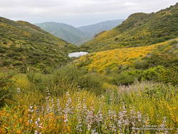
An advantage to doing the run this Spring is that back-to-back wet rain seasons have recharged the area’s streams, and I would (theoretically) be able to get water from a creek on the Mishe Mokwa Trail. Another plus is that all the rain has resulted in historic conditions, with extraordinary displays of a variety of wildflowers.
The day dawned overcast and cool, a deep marine layer covering most of the area. I was running west on the Backbone Trail between Encinal Canyon and Mishe Mokwa. The weather could not have been better for the initial 10+ miles of what I hoped to be a challenging and enjoyable run.
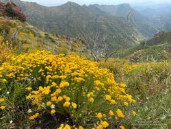
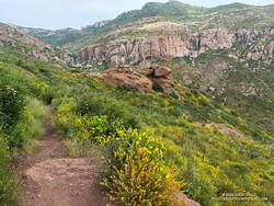
Along the way, I marveled at the explosion of wildflowers along the Backbone Trail. In addition to the extensive bloom of deerweed, pitcher sage, black sage, canyon sunflower and purple nightshade lined the trail.
About 8 miles into the run, as the Backbone Trail crossed the west shoulder of Triunfo Peak, a new trail sign had been posted. It marked the recently completed trail connecting the Backbone Trail to Yellow Hill Fire Road and the top of Triunfo Peak. The new trail replaces a use trail that had evolved here, and expands the route choices when running or hiking in the area.
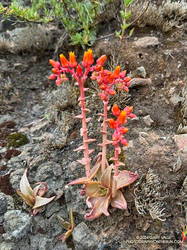
It was still overcast as I ran through the little valley below Mishe Mokwa. Above, I could see the Backbone Trail winding up toward Sandstone Peak and into the clouds. There was a colorful selection of wildflowers along the trail, including speckled Clarkia, canyon live-forever, yellow monkeyflower, woolly blue-curls, and others.
I had planned to make a go-no-go decision at Mishe Mokwa, but something in me had already made that decision miles ago.
When I reached Mishe Mokwa, I didn’t stop. I jogged across Yerba Buena Road and started hiking up the Mishe Mokwa Trail. It was still cool and my legs felt surprisingly good. The only question was: Would the creek at Split Rock actually be running?
Having run the Mishe Mokwa – Sandstone Peak Loop on other adventures, and climbed at Echo Cliffs, I was familiar with the trails. The 6+ mile loop from the Mishe Mokwa parking area is one of the most scenic short loops in the Santa Monica Mountains and deservingly popular.
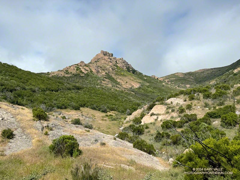
The Mishe Mokwa Trail traverses the rocky slopes directly across the canyon from Echo Cliffs and Balance Rock. The dramatic rock formations are so close that climbers can be heard conversing as they climb the steep faces. This stretch of trail is demanding and has a few steep steps— up and down — that have to be navigated.
As I worked past Echo Cliffs, I passed a large group of hikers that had stopped to enjoy the view from the top of a prominent outcrop.
Earlier, I’d encountered a runner coming down the trail, and he’d been pessimistic about using the creek as a water source. But the burbling sound echoing in the canyon below me left little doubt that the creek was running.
It seemed everyone on the trail converged at Split Rock. When I arrived, one large group was already taking a break there, and by the time I finished getting water, another group joined them.
As a water source, the creek was a bit funky. I debated skipping it but thought of a friend’s comments regarding water sources on the Arizona Trail. How bad could it be? The drainage below Tri Peaks is relatively isolated and there are no cattle. At least, that’s how I rationalized it.
With the cool conditions, I only needed about a half-liter of water. And, of course, a little way up the trail, there was another — probably better — water source. I briefly debated dumping my water and refilling, but decided to continue.
At Split Rock, the character of the trail changes. It becomes much more straightforward as it gains elevation, passes below Tri Peaks, joins the Backbone Trail, and circles around to Sandstone Peak.
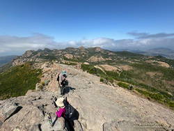
Given the number of people on the Mishe Mokwa and Backbone Trails, I expected the top of Sandstone Peak to be a busy place. But the timing worked out perfectly — only two people were on the summit. Most of the clouds had cleared, revealing Sandstone Peak’s superb views.
Since I did the loop counterclockwise, the return to the Mishe Mokwa parking area from Sandstone Peak was much shorter (and steeper) than the trails to get there. Bush lupine lined the road; its unique fragrance and vibrant color a treat for the senses.
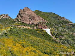
Partway down, the shoulder of the trail had collapsed in a slide. It had been temporarily stabilized with a large white sheet of plastic that must have been visible from miles away. Continuing the descent, I took great care not to miss the turn onto the connector to the Mishe Mokwa Trail. At this point in the run, I didn’t want to do any “bonus mileage!”
The return from Mishe Mokwa to Encinal Canyon is a bit of a blur. Everyone I encountered on the trail — and particularly the mountain bikers — were super-cool, several offering a quick high-five as they passed. The encouragement must have helped — my time returning to the Encinal Canyon Trailhead was faster by a few minutes than the time going out!
This interactive 3-D terrain view shows my GPS track of the Encinal Canyon – Mishe Mokwa Loop – Sandstone Peak Running Adventure. The map can be zoomed, tilted, rotated, and panned. It is initially zoomed in on the Mishe Mokwa loop.
And BTW, even though it was a cool day, I was nearly out of water when I got back to Encinal. It took a little time to purify the water from the creek but having the additional water helped. So far, no obvious problems have resulted.
Some related posts:
– Encinal Canyon to Mishe Mokwa Out and Back Trail Run
– Encinal Canyon to Triunfo Peak
– Balance Rock
– Mishe Mokwa – Sandstone Peak – Grotto Trail Run