Malibu Creek State Park Coast Redwoods

Coast redwood in Malibu Creek State Park

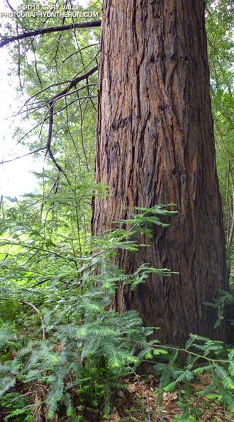
Benefiting from the cool ocean air that flows into Malibu Canyon, the afternoon shadows of Goat Buttes, their north-facing aspect, and the sustaining waters of Malibu Creek and Century Lake, the 100-year-old coast redwoods in Malibu Creek State Park appear to be thriving.


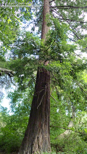
Coast redwoods are not endemic to Southern California. According to Los Padres Forestwatch, the southernmost stand of naturally-occurring coast redwoods is on the coast about 200 miles north of Malibu Creek State Park in an area of Los Padres National Forest designated the Southern Redwood Botanical Area.

Numerous redwoods have been planted in Southern California, and not all of them are doing well. A reprint of the 2004 article “What’s up with the redwoods?” by James Downer, originally available as a resource link on the Urban Forest Ecosystems Institute website, discusses a dramatic decline in coast redwoods planted in Ventura County and describes some of the problems facing this wonderful tree.

Perhaps the Malibu Creek State Park redwoods have a better chance of surviving, and naturally occurring or not, will be enjoyed by Park visitors for centuries to come.

From this morning’s trail run in Malibu Creek State Park.

Some related posts: The Malibu Creek State Park Redwoods Are Dying, Malibu Creek State Park Redwoods: Fighting the Drought

Atmospheric Dynamics

Complex of mountain wave clouds to the north-northeast of Mt. Pinos

These unusual clouds are a complex of lenticular clouds to the north-northeast of Mt. Pinos, photographed this morning from near Mt. Abel. They were produced by strong south-southwesterly winds blowing across the east-west oriented Emigdio and Tehachapi mountain ranges, north of Los Angeles. Here’s another view of these clouds from near the summit of Mt. Pinos.


The winds were associated with the circulation of an unseasonably strong low pressure system off the California coast. The storm system has resulted in measurable rain as far south as Santa Barbara County, and new rainfall records for the date were set in San Francisco, Paso Robles and Santa Maria.


The photographs were taken during a blustery out and back trail run from Mt. Pinos to Mt. Abel on the Vincent Tumamait Trail in the Chumash Wilderness. At the start of the run, the temperature at the Chula Vista trailhead (8400′) on Mt. Pinos was a chilly 39°F. In exposed areas the wind speed was 20-25 mph with gusts to around 50 mph.

Other than the potential for deadfall, the wind wasn’t too bad in the trees. The Vincent Tumamait Trail was in the best condition I’ve seen in years.

Update June 6, 2011. The low that was off the Central California coast Saturday and most of Sunday and an associated cold front set a new rainfall record for June 5 at Santa Barbara Airport, and produced a few sprinkles and showers in the Los Angeles area.

Some related posts: Mountain Weather, Lenticular Wave Clouds, Mt. Pinos – Mt. Abel Out & Back