Category Archives: photography|landscape

Mt. Langley in a Day from L.A.

Cirque Peak from Cottonwood Lakes Basin.
Cirque Peak from Cottonwood Lakes Basin

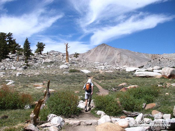
The sky was brightening in the east, and sunrise was approaching when I met Miklos and Krisztina at the Denny’s in Sylmar. We were already wasting light. The plan was to drive from near sea level up to Horseshoe Meadows, at about 10,000′ on the Sierra east side. The hike/run we had in mind was a keyhole loop from the Cottonwood Lakes Trailhead up (old) Army Pass and then down New Army Pass. If we felt OK at the top of Army Pass, we would also do Mt. Langley (14,026′).

The weather forecast looked good. There was a chance of some gusty southwest winds in the afternoon, but temps were warm and there was virtually no chance of T-storms. With a record low Southern Sierra snowpack, there was almost no chance that an ice axe would be required on Army Pass. I was familiar with the route on Langley and down from New Army Pass, and expected to be back to the car well before sunset. But, just in case, the moon was about half full.

Low snow year on Army Pass. June 23, 2007.

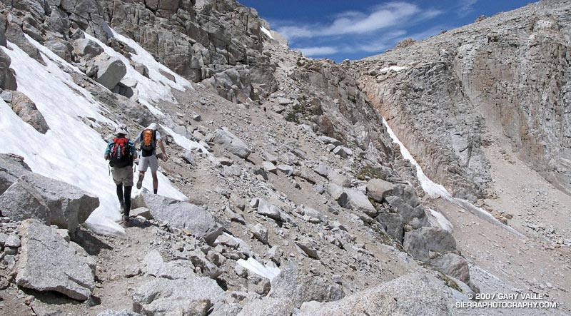
In fact, there had been very little snow on Army Pass, or anywhere else. We reached the pass relatively quickly, and decided to continue to Langley. Now, after another hour of hiking, we were above a prominent rock band that extends across Langley’s south face, and making good progress.

I’ve been convinced for some time that pursed-lip breathing helps me at higher altitudes, particularly when I’m not well acclimated. There’s a skill to it. There seems to me an optimum blend of heart rate, respiratory rate, and the amount of resistance created on exhalation. When all these factors are in balance, the breathing technique is almost automatic and effortless, and it really does seem to help. It certainly seemed to be helping me now.

I topped out a few hundred yards west of the summit, and ambled over to the high point of the peak. On a scale of 1 to 10, I felt pretty good — maybe a 7. Making an effort to stay hydrated, consume plenty of calories, and not push the pace too hard seemed to have worked — at least this time.

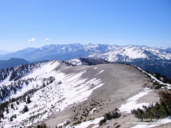
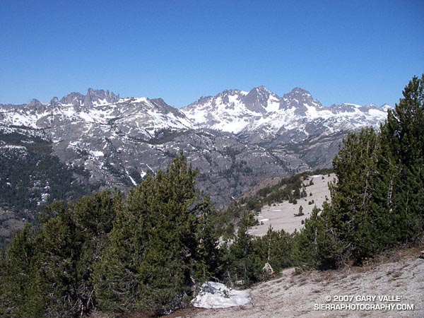
The view along the crest to Mt. Whitney and the peaks of the Kings-Kern Divide was telling. It was remarkable just how little snow there was at the highest elevations of the Sierra. A week before I had been paddling the Kern River. Now I could see why the flow on the upper Kern was dropping so fast.

This wide-angle photograph of Mt. Whitney and the Sierra crest from the summit of Mt. Langley is from a high resolution composite of 8 individual images. It was created using the improved photo-merge tools in Photoshop CS3.

Big horn sheep on the slopes of Mt. Langley. June 23, 2007.

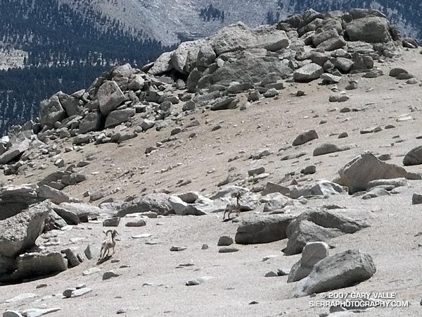
Miklos and Krisztina joined me on the summit, and after taking a few summit photos, we headed down. Screeing down the slopes below the rock band, we were startled when a herd of perhaps 20 big horn sheep rumbled across the slopes below us. They flowed across the rough landscape like quicksilver. Graceful and robust, they moved effortlessly between the rocks and up a small slope. In the moments it took me to react, grab my camera, and turn it on, all but two large rams trailing the group, had disappeared.

Energized by the sight of these fleet-footed animals, we continued down to the saddle at Army Pass, and then up and over New Army Pass. Before sunset we would be back to the car, and before dark, eating dinner at Lone Pine. Before midnight we would be back in L.A. Here’s a Google Earth image and Google Earth KMZ file of a GPS trace of our route.

Note: Going to higher altitudes without properly acclimating can result in very serious, life-threatening illnesses. There is much information available on the Internet regarding altitude sickness and acclimatization. As a starting point see UIAA Medical Commission – Advice and Recommendations and Wikipedia: Altitude sickness.

Related post: Cottonwood – New Army Pass Loop

Rocky Peak

Rocky Peak in the Santa Susana Mountains

Each year, thousands hike, ride or run the 2.3 miles up Rocky Peak fire road to a high point with a nice view of Simi Valley. This is near the point marked “ROAD” in this overview photo. Many turn around here, but some continue along the main road to the Johnson Trail, Chumash Trail, Fossil Point, or beyond.

Another option is to follow a spur trail that branches off the main road at the high point about a quarter-mile to an airy overlook. From this viewpoint you can see the San Fernando Valley and surrounding mountains, and trace your route through Rocky Peak Park’s unique sandstone formations.

The overlook marks the end of the “easy” trail and the beginning of a rough, rudimentary trail that leads east-northeast through large boulders and outcrops to the summit of the Rocky Peak (2714′).

The summit of Rocky Peak is one of the points that defines the border between Los Angeles and Ventura counties. Last year, I was surprised to find evidence that a coyote had recently visited this summit!

Here’s a Google Earth image and Google Earth KMZ file of a GPS trace of my route to the summit.

Some related posts: San Fernando Valley from Rocky Peak, Rainy Morning on Rocky Peak Road.

Snowless San Gabriels

Ridge between Mt. Baden-Powell and Mt. Burnham in the San Gabriel Mountains. 
Ridge between Mt. Baden-Powell and Mt. Burnham

Standing on the summit of Mt. Baden-Powell (9399′), I squinted through the haze at Mt. Baldy (10,064′). Nope, no snow.

It’s not often that the highest elevations of the San Gabriel Mountains are snowless on Memorial Day weekend. If nowhere else, there will usually be a patch of white on the north side of Mt. Baldy. Two years ago there were 10-15 ft. drifts on Baden-Powell that persisted into July. Not this year.

This year, usually dependable water sources might not make it through the Summer. On the way to Baden-Powell I  stopped at Little Jimmy Springs. Descending to the spring, I didn’t hear the usual splitter-splatter of water streaming onto the rocks. For a worried moment I wondered if the spring could already dry.

It wasn’t dry, but the spring was nearly as low as it was in August 2002, following the driest water year ever recorded in Los Angeles. Whether Little Jimmy Spring will last through this Summer, after what is likely to be an even drier year, we’ll just have to see. To date, Los Angeles has received only 3.21 inches of rain since July 1, 2006, and will very likely break the record set in 2001-2002.

When on the trail between Islip Saddle and Mt. Baden-Powell, I almost always visit Little Jimmy Spring. The area surrounding the spring is lush and green, and in midsummer is accentuated with the yellows and reds of wildflowers. There are several impressive Incense Cedars nearby, and one huge tree must have enjoyed the idyllic setting and refreshing waters for at least a few centuries. The tree was threatened by the 2002 Curve Fire, but fortunately only a part of its fire-resistant trunk was burned.

At the spring, I filled my Camelbak to the brim. On the way back from Mt. Baden-Powell, I was planning to climb Mt. Burnham, Throop Peak, Mt. Hawkins and Mt. Islip. Most of these peaks are relatively easy ascents requiring short detours from the main trail. Mt. Islip requires a little more effort, and is about a mile by trail from Windy Gap.

According to my Forerunner 205, the distance from Islip Saddle to Mt. Baden-Powell is about 8.1 miles. Depending on how Islip is done, the total mileage including the five peaks is in the neighborhood of 17-18 miles, with an elevation gain and loss of about 4700′.

Note: Angeles Crest Highway (SR2) was open to Islip Saddle.

Related post: PCT Above Windy Gap.

San Joaquin Ridge

San Joaquin Ridge, near Mammoth Mountain.

Located near Mammoth Mountain, San Joaquin Ridge extends from Minaret Summit (9265′) north about six miles to San Joaquin Mountain (11,601′). Views from this ridge are legend, with broad vistas that include Mt. Morrison, Red Slate, Mammoth Mountain, the Minarets and Ritter & Banner, Mono Lake, and much more. In good weather it is an awe inspiring locale in which to hike, ski or run.


he Minarets, and Mts. Ritter and Banner from San Joaquin Ridge. May 21, 2007.
This day, the conditions for running the ridge are ideal. In the wake of a weak weather system, skies are mostly clear, and a cool breeze reduces the heat of the harsh sun, producing a welcome warmth. Winter snow is already receding from the ridge crest, allowing a choice of routes over, or around, remnant drifts and cornices.

Returning from a high point a few miles distant, bounding strides lengthen, and I seem to soar down the ridge, weaving among the stunted pines, glissading across bands of snow, caressing the wind and flying up or down slopes with equal ease. It has become a run that defines the root experience of trail running and the rewards of being in the mountains. There is freedom of motion — and emotion — in every stride.

Ahead of me, a pair of ravens turn and the Sun glistens from back to wing. Individual feathers ruffle as wings are adjusted to increase lift, and turns are tightened. Soon we are soaring high above the Sierra, and all things seem possible.

Angeles High Country

Angeles High Country

Of all the faces of Los Angeles perhaps the least well known is the Angeles High Country. Entirely within the County of Los Angeles, the lofty peaks and chiseled canyons extend from Mt. Waterman on the west to 10,064′ Mt. Baldy on the east. It is rugged and wild — the home of ancient trees, bighorn sheep, black bears and mountain lions.

This view of the crest is from the Rim Trail, on the steep eastern shoulder of Mt. Wilson. From left to right the prominent peaks are Mt. Waterman (8,038′), Twin Peaks (7761′), Mt. Baden-Powell (9,399′), and Mt. Baldy (10,064′). The lack of snow is indicative of the meager amount of precipitation we’ve had this Winter.

We were running the Rim Trail as part of an approximately 22-mile loop from Shortcut Saddle on Angeles Crest Highway to Mt. Wilson and back. The loop incorporates several segments of the new 50-mile course that is part of the Angeles National Forest Trail Race (formerly Mt. Disappointment).

The segments of the loop that are on the 50-mile course are the Silver Moccasin Trail, Gabrielino Trail, Kenyon DeVore Trail, and the Rincon-Edison Road. Here are a Google Earth image and Google Earth KMZ file of a GPS trace of the route.

Much of the winding 5.6 mile climb out from the W.F. San Gabriel River on the Rincon-Edison Road is steep and shadeless. Rincon-Edison Road is also used (under permit) by off-road vehicles — we encountered two dirt bikes and a jeep.

Chaparral Freeze

Freeze damaged Laurel Sumac in Malibu Creek State Park.

Updated March 6, 2007

As evidenced by their survival, native plants are generally well adapted to the environment in which they live. Fire, flood, drought, heat or cold, they’ve seen it all – or nearly so.

On January 14, 2007 many new record low temperatures for the date were set in the Southern California area. Several locations in the San Fernando Valley recorded temperatures in the 20’s. Pierce College in Woodland Hills plunged to a record low of 20°F (-6.7°C).

The freezing temperatures resulted in extensive damage to fruit crops, nursery stock, and landscaping. The brown leaves of freeze damaged shrubs, trees and other plants are a common sight in the Los Angeles suburbs.

Since the freeze, I’ve run in several areas of the Santa Monica Mountains, Santa Susana Mountains and Simi Hills, and most native chaparral shrubs appeared to have weathered the cold temperatures well, exhibiting very minor, if any, visible damage. However, there are some exceptions.

One obvious exception is laurel sumac (Malosma laurina). I first noticed instances of laurel sumac with damaged leaves and stems on a run at Sage Ranch on January 24. Initially, I thought the damage might be limited to sprouting laurel sumac in the 2005 Topanga Fire burn area, but on subsequent runs damaged plants were seen in several areas unaffected by the fire, including Topanga and Malibu Creek State Parks. Now that the dead leaves and stems have turned brown, the affected plants stand out in the chaparral, and the extent of the damage is easy to see.

The sensitivity of Laurel Sumac and other chaparral plants to freezing temperatures and drought has been studied extensively by Dr. Stephen Davis of Pepperdine University’s Seaver College Biology Department. This research confirms that the leaves and stems of laurel sumac are not as tolerent of freezing temperatures as some other chaparral shrubs. This reduced tolerance probably affects the distribution of the plant, favoring its growth in warmer coastal locations and inland microclimates.

Dr. Davis reports that, in addition to laurel sumac, other species that have been damaged at the lower, colder distributions in the Santa Monica Mountains include green bark ceanothus (Ceanothus spinosis), big pod ceanothus (Ceanothus megacarpus), sugar bush (Rhus ovata), and some hairy-leaf ceanothus (Ceanothus oliganthus). The lowest temperature recorded at his field sites was 10.4°F (-12°C).

A factor in the damage is that the freeze occurred during a period of relative drought. As of January 14, Downtown Los Angeles (USC) had recorded only 1.31 inches of rain since (but not including) May 22, 2006 – a period of nearly 8 months.

Although some of laurel sumac’s adaptations to fire and drought may adversely affect the resistance of its foliage to freezing temperatures, it is precisely these adaptations that will enable most of the freeze damaged laurel sumacs to resprout and survive.

The photograph of freeze damaged Laurel Sumac was taken on the Backbone, Bulldog & Beyond run.