Category Archives: running

Strawberry Peak Traverse

Josephine Peak from the northwest ridge of Strawberry Peak.

When I broke through the top of the stratus layer, bright sun glared from the jagged granitic rocks along the ridge. To the west, Josephine Peak (5558′) was nearly immersed in an ocean of clouds.

The route I was doing was a variation of the Strawberry Peak Circuit described in the posting Spring Growth. Instead of going around the peak on the Colby Trail, this 13-mile loop climbs up and over Strawberry’s summit (6164′), ascending the class 3 northwest ridge, and then rejoins the circuit at Lawlor Saddle. Although a couple of miles shorter than the circuit around the peak, this route has more elevation gain, and the class 2 and class 3 sections of the ridge require careful route-finding.

Class 2, class 3 – what’s that about? Basically, class 1 is hiking, class 2 is easy scrambling where the hands are used for balance, and class 3 is when the scrambling gets serious, and handholds are required. Another element of class 3 climbing is that staying on route can be important. Deviating from an established route may significantly increase the difficulty or hazard. This is certainly the case on the northwest ridge of Strawberry.

Like much of the San Gabriel Mountains, the rocks of Strawberry Peak are old and fractured. Large landslides have originated from the northwest face of the peak. (The Colby Trail passes through the moraine-like debris of one of these slides.) Because of its friable nature, extra care is required when climbing the northwest ridge. Hand or footholds can break, or footing can be lost on a sandy shelf. Or, as described in a story by pioneering aerodynamicist Paul MacCready, the climber can be trapped in a situation where they cannot climb up or down.

The northwest ridge of Strawberry is by far the most frequently climbed class 3 route in the San Gabriel Mountains. Done with care and appropriate skill, the climbing on the ridge can be an enjoyable and unique experience.

On the summit ridge, I admired the steep northwest face of Strawberry Peak as it plunged through the morning shadows to Strawberry Potrero nearly 1500′ below. Did I hear voices down there, or was it just the wind…

Here are a Google Earth image and Google Earth KMZ file of a GPS trace of the route.

North Backbone Trail Revisited

Wind-swept Jeffrey pine near Dawson Peak

I was cold — but not cold enough to do anything about it. I was chugging up the final steep step on Mt. Baldy’s exposed northern flank and didn’t want to stop. Strong winds were gusting out of the northeast, and the effective temperature had to be in the thirties. Mountain wave clouds paralleled the San Gabriels, stretching in a line from southwest of Mt. Baldy to beyond Mt. Williamson.

At the trailhead I’d seen the lens shaped clouds hovering over the mountains and expected it to be windy and cold. I’d changed my single layer long sleeve top for a more wind resistant double layer top and also pulled on some warmer shorts. I had started the climb with lightweight gloves and a  3 oz. rain shell in my pack. The gloves were out of the pack by the first peaklet, but I was still resisting putting on the rain shell.

So why repeat the same adventure on back-to-back weekends? The main reason is that I really enjoyed the route. But there were several more obtuse reasons as well. Last week, my Garmin Forerunner 205 would not turn on*. This is a known issue with an otherwise excellent GPS. However the usual workaround, pressing Mode + Reset + Power simultaneously, would not bring mine to life. So I didn’t get a a GPS trace of the route. The trace is not only useful for determining the approximate length of the route and elevation gain, but for documenting where photographs were taken and the location of interesting features.

This week I used my older Garmin Foretrex 201 GPS. It isn’t as compact or comfortable to wear as the Forerunner 205, and isn’t quite as sensitive, but at least it could be powered on. There were two trees in particular that I wanted to georeference. The first was a Jeffrey pine that had been recently struck by lightning. As it turns out, it didn’t require a GPS to determine its location because it is already marked on the topo as point 8555. The second was a gnarled and ancient Sierra Juniper on Pine Mountain.

Here’s a Google Earth image and Google Earth KMZ file of a GPS trace of the route. The title photograph is of a wind swept Jeffrey Pine on a south facing slope near Dawson Peak, with mountain wave clouds in the background.

*Garmin promptly replaced the unit. As a precaution, I now check that the unit can be powered on after it is removed from the recharging cradle.

Some related posts: Mt. Baldy North Backbone Trail, Mt. Baldy Run Over the Top

Cottonwood – New Army Pass Loop

Rock Creek trail below New Army Pass.
Upper Rock Creek Canyon

The climb up the glacier sculpted canyon hadn’t been too bad. How could it be on a day like this? Winds were light, and the temperature was refreshingly cool – perfect for running in shorts and a lightweight long-sleeve top. As I had worked up the Rock Creek trail, marmots, fat for the Winter, had whistled warnings of my approach and then waddled for cover. Amicable clouds embellished the high mountain sky, and sun-chased shadows quietly set the pace.

Mt. Langley from New Army Pass.

Atop New Army Pass, I marveled at the diverse landscape. To the north loomed the massive hulk of Mt. Langley. Invitingly close, I had climbed the peak from this point several times before. Today, the additional 5 miles and 2300′ in elevation gain were not part of the plan. Just a few hours before I had been in the San Fernando Valley at an elevation of 800′. Now above 12,000′, I was happy to feel more or less normal, be able to run the flats and downhills, and enjoy the day. (See the note regarding altitude sickness and acclimatization at the end of this post.)

New Army Pass (12,300′) is at about mile 12 of the approximately 21 mile loop. On May 1 California Cooperative Snow Surveys reported the Southern Section Sierra snowpack at 177% of normal. Four months and a very hot summer later, remnants of that snow could still be seen on the Sierra crest near the pass.

Long Lake in the Cottonwood Lakes basin.

My route had started at Horseshoe Meadow, climbed to Cottonwood Pass, and then followed the Pacific Crest Trail and a connecting trail to the Rock Creek trail. From New Army Pass the route would drop down to Long Lake, and then head east to Cottonwood Creek, where it would follow a roundabout route back to the trailhead.

Nearly the entire loop is at or above 10,000′, and almost 12 miles of it are above 11,000′. Many miles of the route are in stands of hardy and picturesque Southern Foxtail Pine. A close relative of the Bristlecone Pine, Foxtail Pines can live to be more than 3000 years old.

In places along the crest, impervious trunks of long dead Foxtail Pines lay in the talus. Many of these ancient trees are larger than the live Foxtail Pines surrounding them. In some cases the relic trees are found above the current treeline – a stark reminder of the changeable nature of Earth’s climate.

The title photograph was taken on the Rock Creek Trail at an elevation of about 11,200′ looking west. Mt. Anna Mills is the sunlit peak on the left, and Mt. Guyot is the peak on the right. In the distance are peaks of the Great Western Divide. An USGS aerial photograph of the area suggests that the mound of rocks to the right of the trail may be a moraine associated with a small rock glacier. The red arrow in the aerial photo indicates the approximate position and direction of the photo on the trail. It could be the feature originated as a landslide, but semi-concentric surface ridges in the debris appear to be evidence of fluid motion at some point in the past.

Here’s a Google Earth image and Google Earth KMZ file of a GPS trace of the loop.

Note: There is much information available on the Internet regarding altitude sickness and acclimatization. As a starting point see UIAA Medical Commission – Advice and Recommendations and Wikipedia: Altitude sickness.

Ultimate Direction Solitaire HHS


Ultimate Direction Solitaire HHS


Note: Photo above is of a modified version of the 2006 pack.


There are three basic choices for running hydration: hand bottles, a waist pack, or a back pack. There are also various combinations of these basic themes. If you do much off-road running, chances are good you have at least one version from each category.


I’ve used 20 oz. hand bottles, single and double 20 oz. bottle waist packs, a 50 oz. reservoir waist pack, a 60 oz. reservoir hybrid waist/back pack, and a 70-100 oz. reservoir back pack. Until recently I had not tried any of the waist packs with a horizontally oriented bottle.


Why not? My concern was probably the same that most trail runners would have – would the bottle tend to slip out of the holster while running? Having the bottle fall out on a dirt road might be inconvenient, but on steep-sided trail the bottle might not be retrievable. When I saw the Solitaire on sale I decided to give it a test and see how it worked for me.


Putting aside the question of the bottle slipping for the moment, there are many things I like about this pack. Nestled in the small of your back, the Horizontal Holster System (HHS) carries the weight of the water bottle much better than a diagonally or vertically oriented bottle. There is far less bouncing of the bottle, and sloshing of it’s contents. In addition, the waist belt does not need to be as tight, and  the pack has no tendency to rotate.


For me, the extra capacity of the 26 oz. bottle makes a big difference. I can think of several 50Ks in which the bigger bottle would have been very welcome. In the HHS configuration, a full 26 oz. is more comfortable when running than a full 20 oz. vertically oriented bottle.


There’s enough room in zippered top compartment for an ultralight rain shell, a compact digital camera and a bit more. By itself, a 16 oz. convenience store water bottle will also fit in there. The pack can also be extended using add-on belt pockets, and other accessories.


So what about the bottle slipping? Before being modified, the bottle would work its way several inches out of the holster. The rougher the run, and the more downhill, the more the bottle slipped. Although the bottle never actually fell out of the holster, it required frequent attention.


The bottle “almost” stays in place, so the amount of force required to keep it in the holster isn’t much. My solution was to attach a small diameter elastic cord across both ends of the holster. It doesn’t need to be tensioned and can be easily manipulated when removing or replacing the bottle. I ran with the Solitaire in the Mt. Disappointment 50K, and with this modification, it worked great for me.

Peru Running


Runners on a high plateau above the Sacred Valley of the Incas.


We did this acclimatization run early in our running adventure in Peru. The grain field is on a plateau at about 11,000′, and parallels the Sacred Valley of the Incas, and Urubamba River.


The run took us across the plateau, down to the Maras salt mines, and then down into the Sacred Valley at a little over 9000′. Excited about the trip, we ran most of the way back to the hotel in Yucay. That evening we enjoyed Pisco Sours and an excellent dinner, and then drifted off to sleep dreaming of big mountains and expansive views.


The high peaks beyond the valley are part of the Cordilla Urubamba and are over 5000m (16,400′). The highest point on the Inca Trail, the “pass of the dead woman,” is at about 13,800′. Later in the trip we would cross two 5000m passes while running a circuit of Mt. Ausangate.


The photograph is from July 15, 2003. The trip organizer, Devy Reinstein of Andes Adventures, is a accomplished runner, and a genius at travel logistics and organization.

Montrail Vitesse & Continental Divide Trail Running Shoes

Montrail Continental Divide Trail Running Shoe

Update 09/25/08. According to Columbia Sportswear customer service, the Continental Divide style is in the Fall ’08 line, but will not be continued in Spring ’09.

Update 09/18/08. Sadly, according to Columbia Sportswear customer service, the Vitesse style is no longer being produced and their current inventory of the Vitesse for the fall ’08 season is limited.

Update 01/23/08. My latest pair of Vitesse’s (made in China) seem to be a very different shoe than the dozens of pairs in which I’ve run before. They seemed to be short for the size, a little more narrow in the forefoot, and the cushioning and shock absorption didn’t feel up to par. Montrail was purchased by Columbia Sportswear about a year and a half ago and according to a customer service rep, “manufacturing of the shoes moved to new factories.” An ultrarunning friend had a similar sizing problem with his last order of two pairs of Vitesses, but said the cushioning was OK. Maybe my latest pair was an aberration. I hope so.

Update 08/19/07. Each of my last two pairs of Continental Divides have weighed more than the first pair. The second weighed 30.6 oz./pair, and the third weighed 32.0 oz./pair! My last two pairs of Vitesses have weighed in at 27.0 oz./pair. At only 24.2 oz./pair, the adidas Trail Response 14 is my most lightweight trail running shoe.

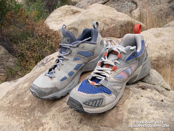
Many runners are fanatical about their shoes. Trail runners are no different, and every runner has their favorite. For several years my favorite trail running shoe has been the Montrail Vitesse. This is a shoe that straight out of the box, I would not hesitate to wear in a tough 50K. I’ve had a couple dozen pairs, and usually have 3-4 pairs that I rotate through from run to run.

It’s not that I haven’t tried other shoes. In their rush to jump into the rapidly expanding trail running shoe market, many well known and respected manufacturers of outdoor gear proffered up at least one trail running entry, and I tried a bunch of them. Like so many over sized and accessorized SUVs, the look was the thing. Many of the shoes were just BAD. There’s no other way to say it.

The reality of the trail running shoe market is that the shoes aren’t just used for trail running. They are used in activities ranging from fitness walking to adventure racing. One early entry became a top seller – not because trail runners liked it – but because it became a trendy shoe on campus. Another bone jarring model left me shaking my head and wondering if the design had been tested by anyone that actually ran in it. Fortunately the trail running market continues to grow, and manufacturers are starting to better address the needs of those that run in the shoes.

So, what’s so special about the Vitesse? First and foremost is the fit. I’ve run 50 miles in the Vitesse and not bothered to take them off for the post race feed. Beyond the fit, it’s a shoe that runs well. It has good shock absorption and cushioning, and a smooth heel-to-toe transition. It’s not too stiff and seems to have a good balance of stability versus flexibility. The tread isn’t overly aggressive and performs well for me on most trail surfaces. Basically I can forget about the shoe and just run.

I’ve tried several of the newer Montrail designs, but none performed as well for me as the Vitesse. That is, until I tried the Continental Divide. I’ve had a pair for about a month, and like the Vitesse, it’s a shoe that’s been comfortable from run #1. It is said to be a replacement for the Leona Divide, but it is a vastly different shoe. In my mind, it is closer in functionality and feel to the Vitesse.

There are some significant differences. The first thing I noticed (on a 100 degree day) is that the Divide is much better ventilated, and runs cooler than the Vitesse. It also seems to have better cushioning. The tongue and ankle cuff of the Divide are not integrated, as in the Vitesse, but the fit around the ankle is excellent and seems to keep out about as much debris.

If you pick up the shoe and twist it, you’ll see that the Divide is more resistant torsionally than the Vitesse. In combination with a medial post and heel strap, it seems to provide excellent stability, without feeling stiff, or obviously interfering in the natural action of the foot.

The outsole width and profile of the Divide is similar to the Vitesse, but lacks the lateral outrigger. The tread pattern is reminiscent of the Leona Divide. Underfoot, it runs well, and seems to have somewhat better traction over a wider range of surfaces.

There are always design trade-offs, and the Continental Divide is no exception. Because they are better ventilated, a little more fine dirt finds its way into the shoe on dry, dusty trails. Your socks will also get wet more quickly in damp conditions – say running through wet grass – but will also dry out more quickly. Another consideration is that the Divide is slightly heavier than the Vitesse (1.4 oz/pair on my scale), and costs about $20-$25 more.

Update 08/19/07. Each of my last two pairs of Continental Divides have weighed more than the first pair. The second weighed 30.6 oz./pair, and the third weighed 32.0 oz./pair! My last two pairs of Vitesses have weighed in at 27.0 oz./pair. At only 24.2 oz./pair, the adidas Response Trail 14 is my most lightweight trail running shoe.

I happened to be wearing the Continental Divide when I got caught in a violent thunderstorm on a 20 mile run at Mt. Pinos, California. The trail conditions were as challenging as they get – torrential rain and hail on steep, storm-gnawed, rock strewn trails. The Continental Divide never skipped a beat.