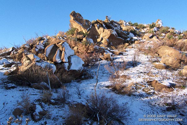
Rocks and snow at the top of the Chumash Trail, near its junction with Rocky Peak fire road, in Rocky Peak Park.
From Thursday’s run in the snow.

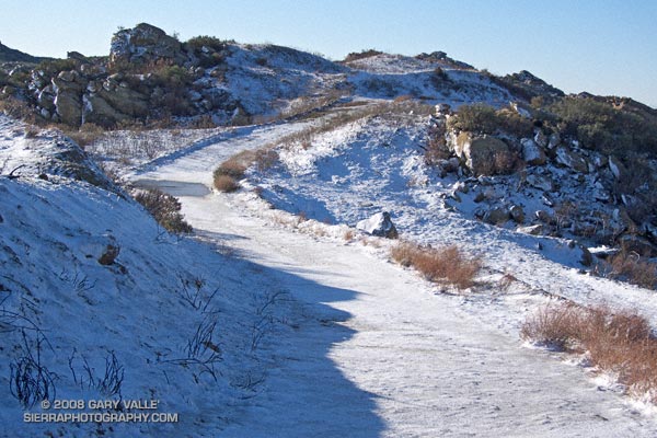
Rocks and snow at the top of the Chumash Trail, near its junction with Rocky Peak fire road, in Rocky Peak Park.
From Thursday’s run in the snow.
Our latest storm added another half-inch of rain to our water year total in Los Angeles. This brings the water year rainfall total to 2.85 inches. This is 1.35 inches above normal for the date. As much as a foot of snow was reported in the Antelope Valley and the snow level dropped to nearly 2000 ft in the foothills and mountains of Ventura and Los Angeles counties.
What’s next? Things should stay dry in Southern California until around Monday when a fast-moving front sweeps through the state. Later in the week, sometime around Christmas, the models are suggesting the possibility of a major system impacting California. We’ll see!
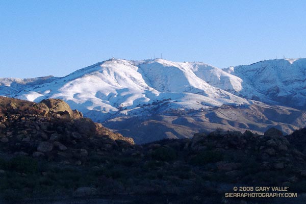
The photograph of Oat Mountain was taken this morning on an out and back run on Rocky Peak fire road. The highest stretches of the fire road were covered with an icy layer of snow.
Related post: Chumash Trail Rocks & Snow
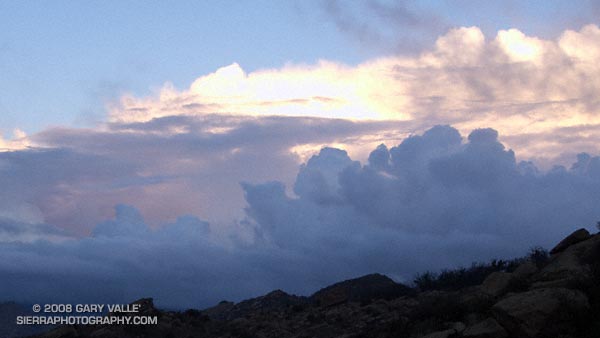
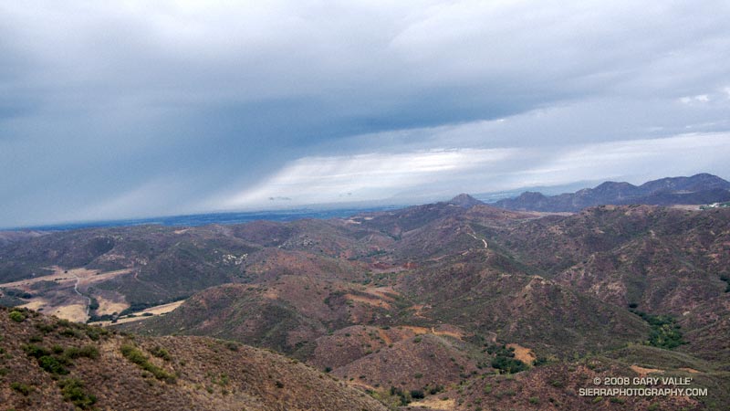
Clearing clouds, northwest of Los Angeles, following the passage of an upper low storm system that resulted in widespread rainfall in Southern California. Several rainfall records for November 26 were broken in Los Angeles County.
Update 12/5/08 P.M. High amplitude flow continues to wreak havoc with forecasts. Our on-again, off-again chance of a shower this weekend might be on again. Original cut-off upper low center is still well offshore, but another low center has developed on the downstream side of high amplitude ridge, and this one is much closer to the Southern California coast. The low appears to be entraining some moisture, and could produce some showers, particularly as the low moves onshore and is absorbed in the main flow. We’ll see!
Update 12/5/08 A.M. No rain is expected in SoCal this weekend… The cut-off upper low set up much further west than suggested by models Tuesday and now is spinning out in the eastern Pacific, nearly halfway to Hawaii. At the moment, it looks like it could be mid-month before our next chance for significant rain.
Update 12/2/08. Computer models have been having a tough time with both the short and medium term forecasts for Southern California. Recent runs have been hinting at the possibility of some rain Saturday or Sunday. This would depend on the strength, position and behavior of an upper low that is forecast to form off the Southern California coast Thursday.
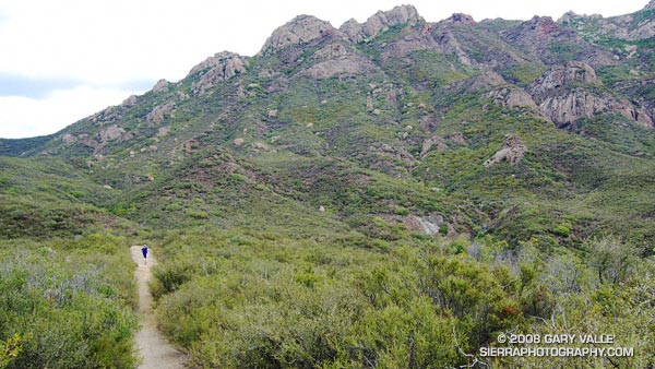
From a run at Sage Ranch Park, near Simi Valley, California.
When I woke to the rumble of thunder, rain pounding the roof, and wind roaring in the trees, I wondered if a planned run of the Boney Mountain Half Marathon course with John Dale was going to turn into an epic. Radar and satellite imagery showed subtropical moisture streaming in from the southwest, producing bands of showers and thunderstorms. Things don’t always look as bad at the trailhead as they do on weather radar, so I grabbed my gear and headed for Wendy Drive.
The weather looked promising driving through Agoura, but the further west I drove, the more ominous the skies became. Somewhere around Lynn Road KNX announced that the NWS had issued a severe thunderstorm warning for the Santa Clarita area, with cloud to ground lightning, heavy rain, possible damaging winds and dime-sized hail. It was with that thought in mind, and a shower pelting the car, that I pulled into the parking area on Potrero Rd.
If anything, weather is fickle, and sometimes that quirkiness can work for you. There was an area of heavy rain to the west, but the activity appeared to be skirting the area, so we opted to start the run.
There were a few sprinkles as we jogged down the blacktop into Big Sycamore Canyon, and a few more as we did the first easy mile of the Hidden Pond Trail. Down in the canyon it was hard to tell what the weather was doing, but after gaining some elevation we reached a better vantage point. Just a few miles away thunderstorms were being swept northeast from the Santa Barbara Channel, across the Oxnard Plain, and into the Ventura Mountains.
Skies darkened and the shower intensity increased as we ran down Ranch Center Fire Road. The wind was blowing in the fitful gusts that precede a thunderstorm, and it felt as if the sky might fall at any moment. With a slight shift in the track of the thunderstorms we might be running in a deluge, dodging lightning strikes.
But it didn’t shift. Following the shower, the sun broke through the clouds just long enough to add glints to the raindrops dripping from the leaves of sycamores and oaks in Blue Canyon. Under overcast skies, we climbed up the Old Boney Trail and into the Boney Mountain Wilderness.
We had not seen a hiker, runner, or rider since turning onto the Hidden Pond Trail early in the run. So it was a bit of a surprise when we rounded a corner and ran into Ed Reid and several other volunteers with the Santa Monica Mountains Trails Council doing trail maintenance on a section of the Old Boney Trail.
Just about any weekend of the year, dedicated members of the SMMTC will be somewhere in the Santa Monica Mountains, working on a trail. To get a better idea of the amount of work done and the number of trails involved, take a look at this list of recently maintained trails! How many of these have you hiked, run or ridden?
There are several ways to help support SMMTC:
See the Santa Monica Mountains Trails Council web site for more info.
Some related posts: Boney Mountain Half Marathon, Return to Hidden Pond
Downtown Los Angeles (USC) happened to be under the right cloud yesterday, and recorded 0.02 inch of rain. There’s a continuing chance of showers in Southern California through the weekend. The area could use some rain. The last storm to produce more than a couple tenths of inch of rain at Downtown Los Angeles was back on February 24, 2008 — more than eight months ago.
Last year, California’s rain season might have been scripted by Dr. Jekyll and Mr. Hyde. Lowland rain totals and the Sierra snowpack were well above normal through the end of February, and then the spigot was turned off. The storm track shifted north, and California had its driest March to May on record. (The March 29, 2008 post in Ed Berry’s Atmospheric Insights blog describes the events that may have led to and maintained this shift.)
Which rain season personality will surface this Winter? Earlier this year the equatorial Pacific tried to transition to El Nino, but the atmosphere didn’t cooperate. As measured by the Multivariate ENSO Index (MEI), the ENSO state has returned to the weak La Nina threshold. And as measured by the Global Wind Oscillation (GWO), an uncooperative atmosphere has continued to cycle through a La Nina base state.
This suggests a winter precipitation outlook with a La Nina flavor — similar to last year. This precipitation map, generated by the ESRL-PSD Composite ENSO plots page, shows the mean November-March precipitation for the U.S. during 9 La Niña events from 1948 to the present. The average La Niña rainfall indicated for coastal Southern California is in the 7.0-10.5 inch range. Last season’s November-March rainfall in Downtown Los Angeles was about 12 inches.
Here’s the current Nov-Dec-Jan precipitation outlook issued October 16 by the Climate Prediction Center. The “EC” means an equal chance of below normal, near normal, or above normal precipitation. The IRI Multi Model Seasonal Forecast for Nov-Dec-Jan is similar. We’ll see what we get!
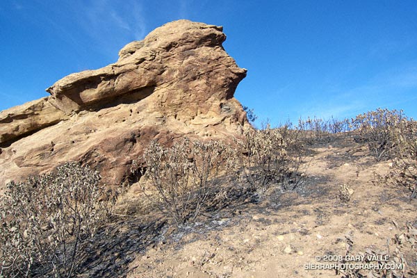
This weather worn sandstone boulder is a familiar landmark to those who do the Chumash Trail. It’s a little less than a mile up the trail, and is at the point where the trail turns east and continues its climb along a cobble strewn divide. The chaparral here and elsewhere along the Chumash Trail was burned last week by the western front of the Sesnon fire.
In the areas bordering the Chumash Trail, the Sesnon Fire appears to have been much less intense than the 2003 Simi Fire. In the case of the Simi Fire, it had been about 15 years since the area was burned, the fuel load was moderately high, and the fire intensity was such that nearly all plant materials were consumed down to the mineral earth.
Recovery from the Simi Fire has been primarily through the slow processes of basal-sprouting and seed germination. Just prior to the Sesnon Fire, common chaparral plants such as chamise, yerba santa, toyon and holly-leaved cherry had recovered about 70% to 90% of their 2003 size.
The recency of the Simi fire appears to have reduced the fuel load available to the Sesnon Fire. In many cases grasses and other annuals (many invasive) were consumed, but adjacent chaparral shrubs were only scorched. Many of these shrubs look like they will probably be able to recover through foliage replacement, rather than crown-sprouting. One exception might be laurel sumac, which appears to have been less fire tolerant.
Update 12/23/08. Only a small percentage of the scorched Yerba Santa are recovering through direct foliage replacement. Most of these plants are recovering through the process of crown sprouting.
In addition to reducing the fire danger, a little light rain would help jump start the recovery process. Computer weather models have been hinting at a change in the weather around November 1, and now seem to be converging on the possibility of a shower in Southern California around Halloween, followed by a front and some rain later in the weekend. That’s still a week away, so we’ll have to see!
Here’s a Google Earth image and Google Earth KMZ file of the perimeters of the Sesnon and Simi Fires, as well as GPS traces of some of the trails in the area.