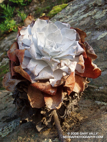
A Chalk Liveforever (Dudleya pulverulenta) at Sage Ranch a few weeks after the 2005 Topanga Fire burned through the area. (Photograph from November 24, 2005.)

A Chalk Liveforever (Dudleya pulverulenta) at Sage Ranch a few weeks after the 2005 Topanga Fire burned through the area. (Photograph from November 24, 2005.)
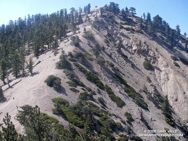
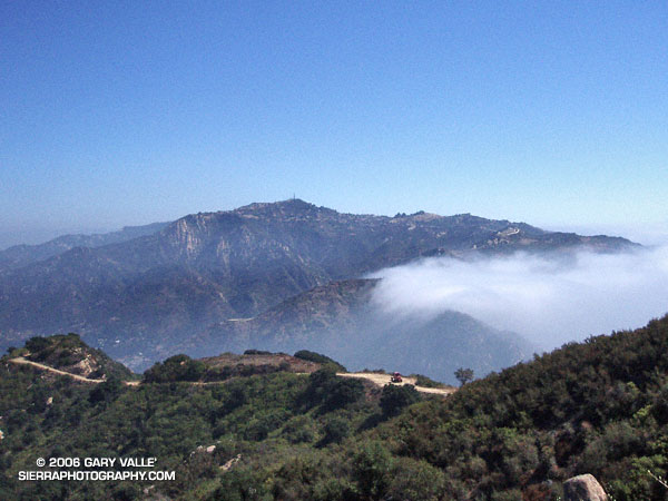
The photograph is of peak 8248, the highest point on Pleasant View Ridge, viewed from the saddle northwest of the peak. Located in the San Gabriel Mountains, Pleasant View Ridge extends northwest about 8 miles from Mt. Williamson to the vicinity of Indian Bill Canyon.
When hikers refer to Pleasant View Ridge, they are usually talking about a 3 mile segment of the ridge that runs from the southeastern summit of Mt. Williamson (8214′) to Burkhart Saddle (6959′). From Mt. Williamson, the ridge follows along a series of 8000’+ summits, then crosses a deep gap to the broad summit of Pallett Mountain (7760’+). From this point, Burkhart Saddle and the Burkhart Trail are another 0.6 of a mile to the west. There is no maintained trail on the ridge, but over time a use trail has developed and is generally (but not always) distinct. In this photograph of the ridge from the PCT, Pallett Mountain is the peak on the left, in the distance.
Mt. Williamson is in the peculiar situation that the register for the peak is not on the peak labeled “Mt. Williamson” on the Crystal Lake topo. According to the Sierra Club Hundred Peaks Section Peak List, the register is normally located on peak 8244, which is the next peak along the ridge to the northwest. What is even more peculiar, peak 8248, which is a little further on the ridge, is the highest point of all three!
The section of Pleasant View Ridge between Mt. Williamson and Burkhart Saddle is commonly done as part of a 13 mile loop from Eagles Roost. In order to protect critical habitat of the mountain yellow-legged frog, the Forest Service has closed the PCT between Eagle’s Roost and the Burkhart Trail. In addition, Angeles Crest Highway (SR2) is now closed 0.25 mile west of Eagles Roost. (Update May 27, 2007. Angeles Crest Highway has since been re-opened to Islip Saddle. It was open to Islip Saddle on May 27, 2007, but closed beyond this point. It looked like the road past Islip was being resurfaced.) If the PCT detour suggested by the Forest Service is followed, the loop length is increased to about 14.4 miles, and it is necessary to hike/run a 2.4 mile stretch of Angeles Crest Highway. Done this way, the route has an elevation gain and loss of 4000′ or so.
I usually like to do the loop in the counter-clockwise direction, and that’s what I did on this day. It’s nice to get a big chunk of elevation gain done in the morning while it’s cool, and then have a net elevation loss doing the ridge. Also, except for a few downed trees, the running is outstanding from Burkhart Saddle down to Little Rock Creek. Some Western Columbine (Aquilegia formosa) was blooming along Little Rock Creek.
Here is a Google Earth image and Google Earth KMZ file of a GPS trace of the loop with the PCT detour through Buckhorn Campground. The ridge parallels the San Andreas Fault zone, whose linear features can be seen in the valley below. This Google Earth image shows the approximate position of the fault zone in relation to Pleasant View Ridge loop. It also shows the section of Pleasant View Ridge northwest of Burkhart Saddle.
For more information regarding the PCT detour see the News section of the Angeles National Forest web site.
Updated May 5, 2008. Added elevation profile.
Google search: $g(Pleasant View Ridge), $g(Mt. Williamson), $g(Pallet Mountain), $g(Burkart Trail), $g(trail running), $g(mountain yellow-legged frog), $g(PCT), $g(Pacific Crest Trail), $g(San Gabriel Mountains)
Related post: Peaks Along Pleasant View Ridge
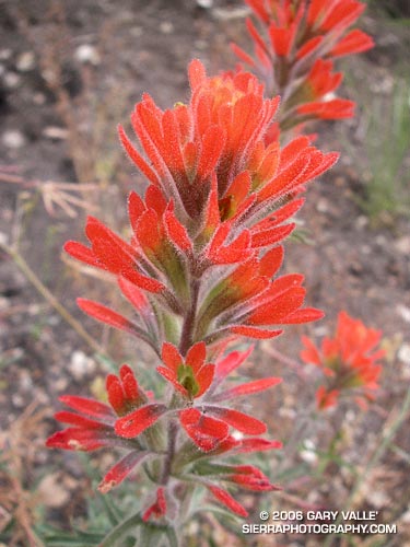
In this case, Indian Paintbrush (prob. Castilleja affinis), Scarlet LarkSpur (Delphinium cardinale), and Indian Pink (Silene laciniata) in the Cheeseboro Canyon area of Southern California.
As is the case with many wildfires, one of the side effects of the 2005 Topanga Fire has been to promote a population explosion in many species of wildflowers. Scarlet Larkspur has been especially prevalent in some areas, such as upper Cheeseboro Canyon.
These photos were taken on a run to Simi Peak from the Las Virgenes Rd. trailhead of the Upper Las Virgenes Open Space Preserve on June 11, 2006. I like to go out via upper Las Virgenes Canyon, and come back through Cheeseboro Canyon. This variation is about 16 miles, with an elevation gain and loss of about 2000 ft. The run can be extended to about 21 miles by starting at El Scorpion Park, near Vanowen and Valley Circle. Following are links to trail maps for Upper Las Virgenes Canyon Open Space Preserve and Cheeseboro/Palo Comado Canyons.
Related post: Simi Peak Out & Back
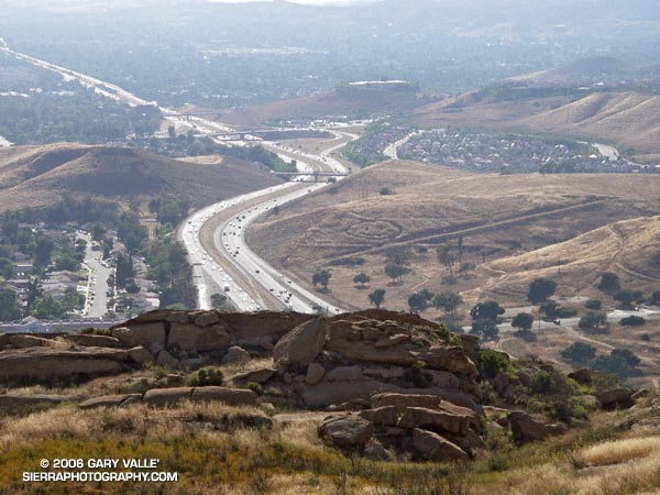
A crop circle, Simi Valley style, from the Hummingbird Trail.
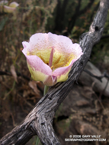
When the hills and valleys of Southern California turn golden brown, and temperatures reach into the nineties or beyond, mixed in among the desiccated grasses, enjoying the heat and the sun, may be the delicate pink to purple of a Plummer’s Mariposa Lily (Calochortus plummerae).
Previously listed by the California Native Plant Society as being rare, threatened, or endangered, the Plummer’s Mariposa is now listed as uncommon and fairly endangered in California.
Note: Plummer’s Mariposa Lily (Calochortus plummerae) and Foothill Mariposa Lily (Calochortus weedii var. intermedius) are closely related species that have intersecting ranges and similar characteristics. C. plummerae is more frequently reported in Los Angeles County.
Saddle Peak from BackBone Trail on Bulldog Loop
Was up early, hoping to beat the heat and do a local run. It looked as though thick high clouds would keep temps down for a while, so several good runs were a possibility. After some debate, I decided on an out and back run to Saddle Peak.
My usual route starts at Piuma Rd. & Malibu Canyon, and follows the Backbone Trail approximately 6.5 miles to a short spur trail which leads to the actual summits of Saddle Peak. Much of the route used to part of the Bulldog 50K, and can be combined with the Bulldog Loop to do a self-supported 27.5 mile run. Here’s a Google Earth image of a GPS trace of both routes.
While both the Bulldog and Saddle Peak routes have great views, are about the same length, and have similar elevation gains, there is one significant difference. Except for a short, 0.3 mile stretch along Piuma Rd., all of the Saddle Peak route is on single track trail.
The trail covers a variety of terrain and habitats. Some sections are lush and shaded, with bay trees, moss-covered rocks and several species of ferns. Other sections are rough and exposed, and can be brutally hot. Not far from where the trail tops out, it passes through a unique area of steeply inclined sandstone slabs.
(Photograph of Saddle Peak is from a Bulldog Loop run on October 2, 2005.)