After the Station Fire: Ten Miles – Four Peaks

Mt. Lowe from Mt. Disappointment

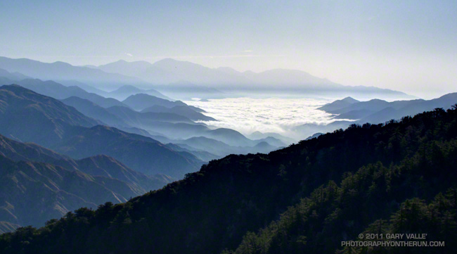
A run or hike doesn’t have to be long or difficult to be enjoyable! It had been a while since I’d done San Gabriel Peak, Mt. Markham, and Mt. Lowe; and although I’d run within a quarter-mile of the summit of Mt. Disappointment several times, I’d never done the last bit up to the peak. All four of these peaks can be done in a (round trip) run/hike of less than ten miles, with a cumulative elevation gain/loss of around 3000′.

Depending on where you prefer to park, the run/hike can start at the San Gabriel Peak Trail trailhead, which is about one-third of a mile up the Mt. Wilson Road, or at Red Box on Angeles Crest Highway. Parking at Red Box requires running/hiking on Mt. Wilson Road to the trailhead.


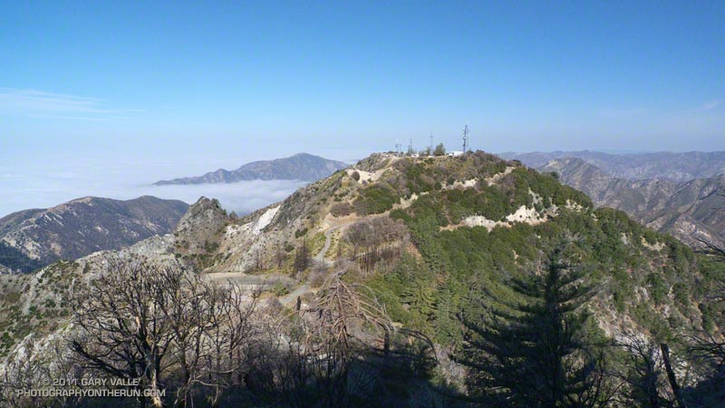
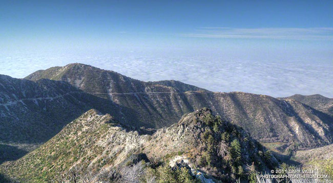
The San Gabriel Peak/Mt. Disappointment trail climbs up through a forest of chaparral, canyon live oak, and Bigcone Douglas-fir about 1 1/2 miles to the Mt. Disappointment road, just below the antennae-infested summit of the peak. Along the way there are great views of the canyon of the West Fork San Gabriel River and San Gabriel Peak. The paved road is followed south (left) to a sharp switchback and then a short distance up to the top of Mt. Disappointment (~ Mile 2.1).


In Trails of the Angeles, John Robinson describes how government surveyors lugged their equipment to the top of Mt. Disappointment in 1875, only to discover that another peak to the southeast was higher. That peak was San Gabriel Peak. Except for Strawberry Peak (6164′), San Gabriel Peak (6161′) is the highest of the front range peaks. It is the most prominent peak on the eastern skyline when viewed from the San Fernando Valley, and is sometimes mistaken for Mt. Wilson.

I imagine it was a bit easier for me to get over to San Gabriel Peak than for the surveyors when they did the peak’s first ascent. All I had to do was run a third of a mile down a paved road and pick up the San Gabriel Peak Trail on the southeast corner of the switchback. The trail up to San Gabriel Peak forks to the left off the trail to Markham Saddle about a tenth of a mile from the switchback.


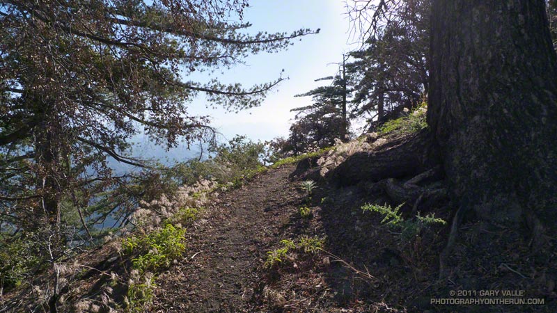
The divide extending from Mt. Disappointment to Mt. Wilson was the approximate boundary of the Station Fire in this area. Although the summit of San Gabriel Peak burned, much of the northeast side of San Gabriel Peak and Mt. Disappointment did not. From what I can determine, the northeast side of these peaks last burned in the 1898 “Mt. Lowe” fire. There’s a nice section of trail just below the summit of San Gabriel Peak that passes through a corner of Bigcone Douglas-fir forest that was not consumed by the Station Fire.

After enjoying the panoramic view from the top of San Gabriel Peak (~ Mile 2.9), I retraced my steps back down to the “main” trail and continued to descend to Markham Saddle and the Mt. Lowe fire road. At this point another trail begins on the Mt. Markham side of the road. This trail leads southwest to a saddle between Mt. Markham and Mt. Lowe. Mt. Lowe Road is closed between Markham Saddle and Eaton Saddle because an active rock slide destroyed the road just west of Mueller Tunnel.


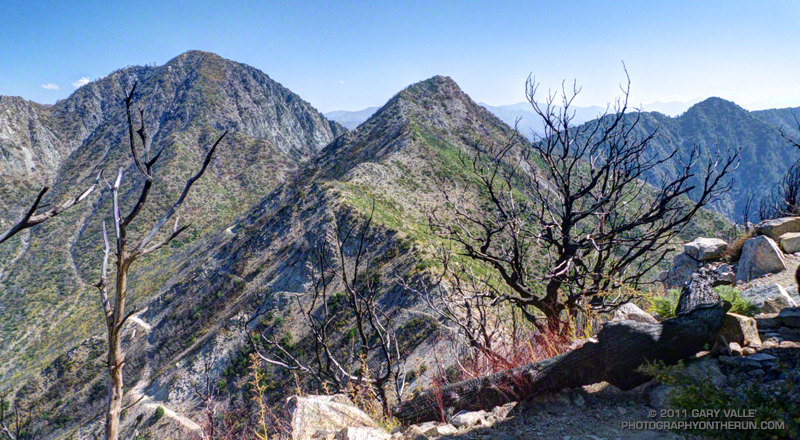
From the Markham-Lowe saddle a path follows the southwest ridge of Mt. Markham about a half-mile to its summit. The route up the ridge is relatively straightforward, but a steeper section requires a little scrambling over fractured, loose rock. The high point on Mt. Markham’s elongated summit ridge appeared to be a pile of rocks covered with Turricula. A little further out on the ridge was a clearing with a rusty can that may have been a summit register (~ Mile 5.1).


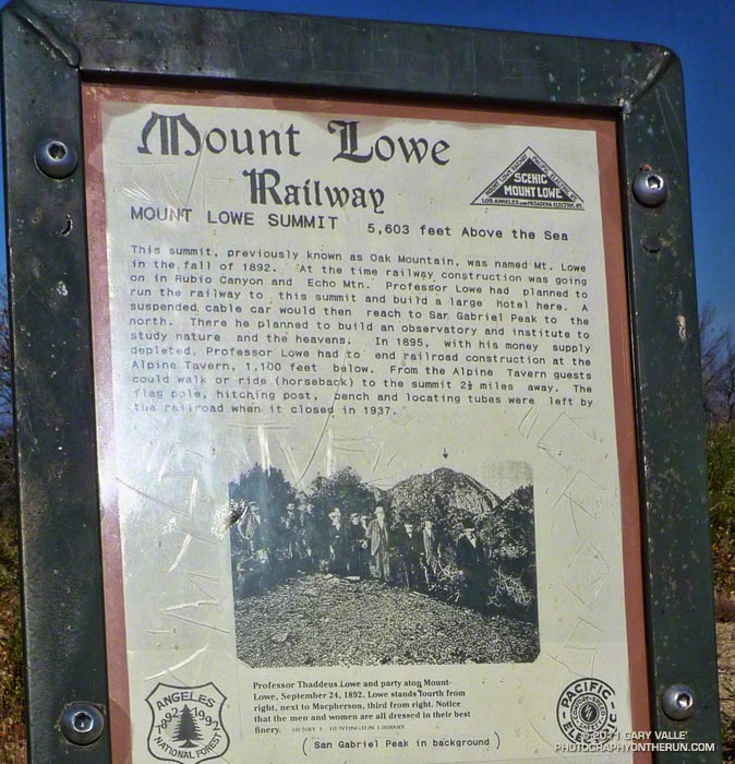
Returning to the Markham-Lowe saddle, less than a half-mile of moderate uphill led to the summit of Mt. Lowe (~ Mile 6.0). There’s a bench here, along with locating tubes pointed at various landmarks. As explained by the interpretive sign on the peak, Professor Thaddeus Lowe had planned to build a large hotel on the summit, serviced by the Mt. Lowe Railway. In his grand vision, a suspended cable car would have continued to San Gabriel Peak, where an observatory was to be built. Here’s a map of Mt. Lowe area trails and landmarks created by The Scenic Mt. Lowe Railway Historical Committee.

It was on the way back, near Mt. Disappointment, that I heard and saw the F-18s described in So Many Heroes. It turns out the fighters had done a flyover as part of a 9/11 Memorial dedication in Pasadena.

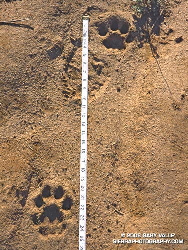
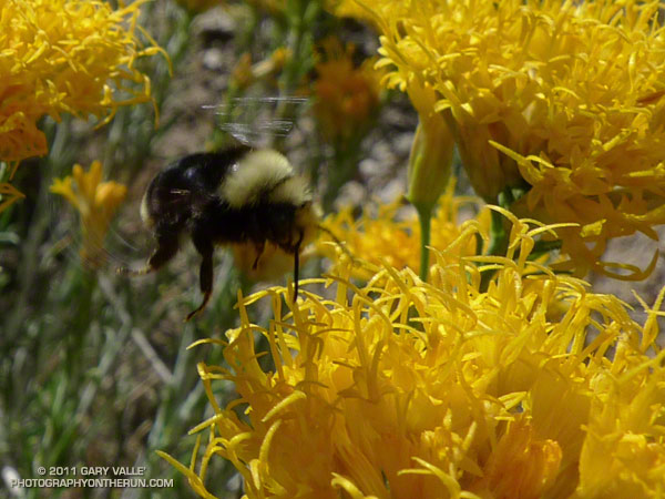
Turricula (Poodle-dog bush) Update


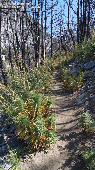
Turricula was present virtually everywhere along the route that had been burned, and could not entirely be avoided. It was especially prevalent on the path to summit of Mt. Markham from the Markham-Lowe Saddle.

I’ve been exposed to Turricula now on a number of runs, and except for the first time, when I literally waded through unbroken stands of the sticky young plants, it hasn’t been a problem — even wearing running shorts and short-sleeves. I’ve had a little irritation on my ankles, or sometimes along my waistband, or a random spot here or there, but it’s been no big deal. Certainly nothing like the widespread inflammation, swelling and blisters the first time!

Of course now I at least make an attempt to avoid the plants. And I also wash off my arms and legs at the earliest opportunity after being exposed to Turricula.

It also seems the older plants don’t have as much of the “exudate” on them, since my legs and arms haven’t become sticky from brushing up against the plants. Anecdotal evidence suggests that in the older plants irritation results from the almost microscopic hairs on the plant. It is thought these irritating hairs are more easily broken and shed as the plant ages.

So Many Heroes

West Fork San Gabriel River to Mt. Baldy

I stopped running and listened, it was eerily quiet. No airplanes overhead. No traffic on the road below. The silence triggered thoughts of this day, a decade ago.

Suddenly the silence was broken by the unmistakable sound of a jet fighter. Big engines, to the northeast of Mt. Disappointment. Not high, but high enough I couldn’t find the source in the haze and glare. Slowly the roar faded, and I started to run again.

Earlier this morning I’d heard a recording of that sound in a news report leading up to the 9/11 ceremony at the World Trade Center. The reporter had commented that in the scramble to intercept Flight 93, the fighters were virtually unarmed. Apparently the fighter pilots had been prepared to ram the plane. But as we know, other heroes were already taking action.

Faintly at first, I heard a growing, growling, thunderous sound heading toward the mountain and started searching the sky. This time I saw them. Two  F-18s maybe three thousand feet overhead, in a long, arcing turn. Increased security? Part of a 9/11 memorial flyover? Something else? At the time I had no idea, but it put into focus the events of that day, and other days.

So many heroes, so many sacrifices…

Mt. Baldy Run (Part Way) to the Top 2011

Mt. Baldy Run to the Top Registration Area and Start

Somewhere around the junction of the 210 and 605 I saw a flash of lightning to the south. As if the flash had been a warning, a gust of wind buffeted my car, and a blizzard of dust and debris blew across the freeway. Then it started to rain. Not good — especially when you’re on your way to a race that ends on top of a 10,000′ mountain.


A complicated weather scenario had developed for race day. A very moist layer of monsoonal moisture had been pushed up into Southern California from Baja by a combination of a weak upper level trough off the coast and big upper level high over Four Corners. A combination of factors including an unseasonably strong jet stream had helped trigger a band of showers and thunderstorms that extended from west-southwest off the coast, across the Los Angeles basin, and into the San Gabriel Mountains.

When I drove into the Mt. Baldy Ski Lifts parking lot at around 6:45 am it was raining hard enough I didn’t want to get out of the car. Procrastinating, I went through the admittedly optimistic ritual of applying sun screen. After a few minutes the rain tapered off to sprinkles and I walked down to the Start Line to pick up my bib. The word was conditions were improving and it looked like we were going to be able to get in the race.


Each year the Baldy Run to the Top attracts 500 to 600 runners. Some are the best of the best and will run the seven miles and nearly 4000′ of elevation gain in under 75 minutes. About two-thirds of the runners usually finish in around 2:15 or less.. A few just want to give it a go and soon find that climbing the rough equivalent of 6500 stairs — at altitude — is more than they bargained for.

Usually the weather is pretty good — some years are a little warmer or cooler, or have a few more clouds than others, but blue skies and sunshine are the norm, and significant rain — or lightning — usually isn’t a problem.

It was deceivingly warm as runners gathered at the start line. The wind chill on top was reported to be a chilly 38 degrees. A few runners had on extra clothing, and a number of runners had an extra top or shell tied around their waste. Some had extra gear stuffed in their packs, but a few — including a couple of shirtless runners — had nothing to combat the weather.


Here’s a UCAR regional NEXRAD composite radar image from about 8:00 am. The approximate location of Mt. Baldy is marked by a black triangle near the center of the image. (Note that radars in the region vary in how they show a particular area and that a cell may be stronger than indicated in the composite. Also there’s some “clutter” in the image that isn’t necessarily rain.)

With what sounded like a more reserved “3… 2… 1… GO!” the race started and pounded down the wet pavement to Manker Flats (6160′), where it turned up the ski area service road. The (mostly) dirt road would take us to the Notch (7800′) and then the top of Chair 4 (8600′). From there a trail would take us across the exposed Devil’s Backbone, then across the south face of Mt. Harwood, and on to the final gut-wrenching 700′ climb to the summit of Mt. Baldy (10,064′). Here’s an interactive Cesium browser View of the race course.

The weather on the way up to the Notch was a little unsettled, but great for running. There was a mix of clouds and sun, and even a brief shower, but overall it looked like the weather might be improving.

Just before rounding the last switchback up to the Notch, a runner with a bib was running down. This was odd because he was running well. Why would he have quit the race? Running up to the aid station at the Notch I still hadn’t caught on, and was wondering why so many people were standing around at the aid station.

That’s when I learned that about 45 minutes into the race, on the recommendation of SAR officials, the race had been shut down. I’m not sure what the “final straw” was but would guess it was nearby thunderstorms and perhaps a growing concern that rain and wind associated with a rapidly developing cell could cause serious problems for runners not prepared for inclement weather.

Here’s what a regional composite radar image looked like at around 9:00 am, and then just one hour later, as a “train” of cells about 20 miles from Mt. Baldy continued to develop and stream into the San Bernardino Mountains in the area of Silverwood Lake, Crestline and Lake Arrowhead.


Lightning was not only a risk for runners, but for the 50+ SAR and fire personnel spread across the mountain, and the 25+ volunteers that would be on top of the mountain for the duration of the event.

There was lightning in the area. We saw it driving to the race and I heard at least one clap of thunder while warming up before the race. Here’s an image of Astrogenic StrikeStar lightning detections in the southwestern U.S. from 10:00 pm PDT Sunday to about 1:30 pm PDT race day. Note the high percentage of cloud-ground strokes.

As this composite radar loop from WSI Intellicast.com shows, bands of showers and thunderstorms streamed into the San Gabriel and San Bernardino Mountains most of Labor Day. Cells were moving relatively rapidly and developing over a wide swath that extended from west of Mt. Baldy south and east to San Diego and Palm Springs. (Mt. Baldy is just north of ONT on the radar map.)


It was pretty much a crapshoot where a particular cell would develop, how strong it would be, and what its extent would be. This regional radar image shows a cell that moved into the Baldy area around 1:00 pm, and this Google Earth/NEXRAD image shows the same cell in relation to  Mt. Baldy at around 1:30 pm.

As frustrated as I was to stop at the Notch, I don’t think there’s any question that officials made the right decision when they shut down the race. And I think most runners understand that it’s not whether a particular runner was able to make it up to the summit and back down OK, but what could have happened with several hundred people on the mountain and an ever-so-slight change in that wavering stream of heavy showers and thunderstorms.

Some related posts: Thunderstorm, Mt. Baldy Run to the Top 2009, Mt. Baldy Run to the Top 2007

Mountain Lion Saga


Mountain lion tracks at Sage Ranch Park in the Santa Susana Mountains, near Los Angeles.
Mountain lion tracks at Sage Ranch Park

Originally posted November 25, 2006. Updated  November 11, 2020.

Nature isn’t necessarily nice. Behavior and interactions among animals are often violent. So it is with mountain lions. But the mountain lions of the Santa Monica Mountains also have to cope with the additional problems of living on an island of lion habitat in the middle of an ocean of urban sprawl.

National Park Service Biologist Seth Riley and P1, the patriarch lion of the Santa Monica Mountains National Recreation Area lion study.
National Park Service Biologist Seth Riley and P1, the patriarch lion of the Santa Monica Mountains National Recreation Area lion study. NPS photo.

The mountain lion tracks above were photographed on a run at Sage Ranch Park in late January 2000. They might have been made by a young male mountain lion designated P3, whose territory encompassed this area. There is also a possibility there were from an older female lion, P4 that frequented the Rocky Peak area. Unfortunately, both these animals were killed in late 2004 by eating prey (coyote) that had eaten rodents that had consumed anticoagulant-based poisons. These poisons are used by parks, schools, golf courses, and housing developments for rodent control.

The P3 and P4 pumas were tracked as part of an ongoing study started by the National Park Service in 2002 to learn more about mountain lions in the Santa Monica Mountains National Recreation Area. As of May 2012, twenty-six mountain lions, P1 to P26, have been tracked, and their history has been quite a saga.

The patriarch of the lions in the study is P1. He was the first lion captured and collared in 2002, and at that time was estimated to be 5-6 years old. In his prime, P1 was a large, 140+ lb. male whose territory was essentially all of the Santa Monica Mountains. In August of 2004, P1 and P2 – the only female lion known to be in P1’s range – produced a litter of four cubs — two males (P5 and P8) and two females (P6 and P7).

Despite high hopes for the lions and their new litter, things turned ugly in August of 2005, when P1 killed his mate P2. A few months later, in June of 2006, P1 also killed one of the 22-month-old females from the litter, P7. According to biologists these were not the actions of a lion run amuck but were most likely related to conflicts over kills, or in the case of P2, a mother protecting her offspring.

Mountain lion P13
Mountain lion P13. NPS photo.

As might be expected, the young males from the litter, P5 and P8, headed for opposite ends of P1’s territory. However, urbanization and limited linkages essentially prevented their escape to other wildland areas.

In early September 2006, P5 was likely killed by P1, and in a development that surprised researchers, P8 appeared to have been killed by an unknown lion, probably male, inside of P1’s territory. The “unknown lion” was the male P9, who was killed by a vehicle on Las Virgenes road in July 2007.

One other female lion was collared and designated P13. DNA testing indicated that P13 was a daughter of P6. At that time P6 was the only surviving lion from P1 and P2’s 2004 litter.

One of three mountain lion kittens found in May 2010 by National Park Service researchers in an area of the Santa Monica Mountains west of Malibu Creek State Park
One of three mountain lion kittens found in May 2010. NPS photo.

P1 appears to have been injured in a battle for dominance in March 2009. A bloody radio collar and tufts of hair were found in a tree in Hidden Valley, near Thousand Oaks. P1’s opponent was suspected to be P12, a lion collared in December 2008, and the first lion to be tracked crossing the 101 Freeway. Scat found three weeks after the fight was genotyped, and found to be P1’s.

In May 2010 P13 had a litter of three kittens — P17 (female), P18 (male), and P19 (female). The father was P12. Since P12 originated from an area other than the Santa Monica Mountains, this increased the genetic diversity of the mountain lion population in the study. P18 was killed August 30, 2011, attempting to cross the 405 freeway.

It is unclear how many male lions now inhabit P1’s original territory. P12’s collar is no longer functioning. P18 was killed August 30, 2011, attempting to cross the 405 freeway. P15 was found deceased on September 11, 2011. Reportedly another male lion has been photographed in the area.

In May 2010 a male lion living in the Santa Susana Mountains west of I-5 was collared and given the designation P16. This is the first lion to be followed in the Santa Susana Mountains since P3 and P4 died in 2004, after eating contaminated prey. P21, an adult male, is also being tracked in the Santa Susana Mountains. Both P16 and P21 have made excursions into Angeles National Forest, and P16 remains there.


Mountain lion home ranges

The map above shows the home ranges of mountain lions P10, P12, P13, P14 and P15 in the Santa Monica Mountains, and some monitored locations of P16 in the Santa Susana Mountains. Here is another map that shows the home ranges of the mountain lions P1 to P12 in the Santa Monica Mountains, Simi Hills, and Santa Susana Mountains. It was adapted for the web from this NPS map (PDF), produced in 2009.

The Puma Profiles page of the SMMNRA website lists the mountain lions that have been studied. More information, news releases, maps, and photos can be found on the main NPS Lions in the Santa Monica Mountains? page.

The mountain lion saga continues…

Some related posts: It’s Raining Mountain Lion Tracks!, Mountain Lion Tracks on Rocky Peak Road

Johanna Turner of CougarMagic.com has captured breathtaking stills and videos of the area’s mountain lions and other wildlife.

Following are some previous updates to this post, with links to additional articles and information.

Update October 24, 2012. The remains of P-25, an approximately one-year-old female mountain lion were discovered by hikers in Point Mugu State Park on Sunday. P-25 and P-26 (male) are the offspring of P-12 (male) and P-13. The death did not appear to be the result of a conflict with another lion. A necropsy is pending.

One of the kittens of P19. NPS photo.

Update October 18, 2012. This summer NPS biologists discovered two mountain lion kittens, P-23 (female) & P-24 (male), east of Circle X Ranch in the Santa Monica Mountains. They are the offspring of P-12 (male) and P-19, a daughter of P-12. The kittens were outfitted with tracking devices.

Update June 18, 2012. Analysis of the DNA of the mountain lion killed by authorities in downtown Santa Monica on May 22 revealed it is related to lions that reside north of the 101 Freeway. One possibility is that the approximately three-year-old lion was the offspring of mountain lion P-12. P-12 has been documented crossing the 101 Freeway in Agoura and is the only lion known to have done so.

Mountain lion P22. NPS photo.

Update May 26, 2012. Earlier this Spring biologists from Santa Monica Mountains National Recreation Area (SMMNRA) captured an adult male mountain lion in the Griffith Park area. Designated P-22, the approximately three-year-old lion is the first to have been photographed east of Cahuenga Pass and within the Santa Monica Mountains eco-region. The lion was fitted with a GPS collar and released where it was captured. According to Kate Kuykendall, Public Affairs Officer for the SMMNRA, preliminary genetic analysis by UCLA indicates that P22 is likely from the Santa Monica Mountains, which would mean he crossed both the 405 and the 101 Freeways.

Mountain lion P15. NPS photo.

Update November 21, 2011. On October 4, 2011, the National Park Service announced that male mountain lion P-15 has been killed. It was the first documented intentional human-caused death of a mountain lion in the Santa Monica Mountains. P-15’s collar stopped transmitting on August 25, 2011. P-15 was discovered on September 11, 2011, following a report of a dead mountain lion. The California Department of Fish and Game and the National Park Service are seeking information related to the death of P-15 and the parties responsible. With the addition of $5000 from the City of Malibu, the reward being offered for information leading to the arrest and conviction of the poachers currently stands at $16,700. The DFG Cal Tip Hotline is 1-888-334-2258.

Update August 7, 2009. According to Where the Mountain Lions Live in the Santa Monica Mountains in laist.com, P1 may have survived the fight with another mountain lion back in March. DNA from scat collected about two weeks after the fight matched P1!

Update March 28, 2009. There was sad news earlier this month. According to an article in the Daily News, mountain lion P1, the long-standing patriarch of the Santa Monica Mountains, appears to have lost a battle for dominance with another mountain lion. A bloody radio collar and tufts of hair were found in a tree in Hidden Valley, near Thousand Oaks. P1’s opponent is suspected to have been P12, a lion collared in December, and the first lion to be tracked crossing the 101 Freeway.

Update October 6, 2008. The Ventura County Star reported that a young male lion was found dead on October 2 on the 118 freeway, just west of Rocky Peak Road. A wildlife passageway crosses under the freeway nearby and has been used by at least one other lion. On July 18 a mountain lion was reported in the area of the Chumash Trail.

Update May 1, 2008. NPS wildlife biologists are currently aware of 4 lions in the Santa Monica Mountains — 2 recently radio-collared young males designated P10 and P11, and P1 and P6. There is probably at least one more female, the mother of P10 and P11. A remote camera picture has also been taken of a lion in the Simi Hills.

Update January 25, 2008. An article in the Simi Valley Acorn reported that on January 13, 2008, a mountain lion was discovered in an abandoned building near Chatsworth Reservoir. Two days later there was another mountain lion sighting in the nearby Simi Hills by employees at the Santa Susana Field Laboratory.

Update August 7, 2007. According to an article in the Malibu Times, on July 31 a five or six-year-old mountain lion was hit by a car near the tunnel on Malibu Canyon Road and died shortly thereafter. The mountain lion, designated P9, was recently collared, and along with P1 and P6 was one of three mountain lions being tracked by the NPS. There is speculation that P9 may have been the unknown lion that killed P8.