Category Archives: nature|wildfire

Springs Fire 2013

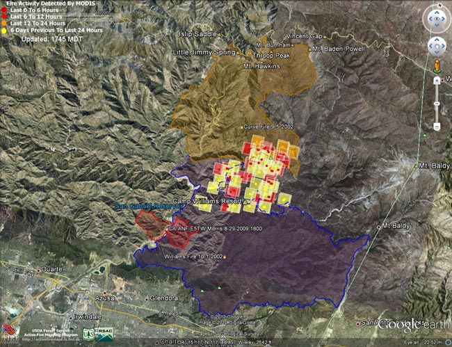
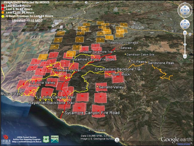
Springs Fire MODIS fire detections as of 05/03/13 1115 MDT

Update May 13, 2013. According to the CAL FIRE website the Springs Fire was 100% contained on May 11 at 24,251 acres. The interactive Google Earth browser view of the Springs fire perimeter has been updated with the fire perimeter from GEOMAC timestamped 05/07/13 0348. This is a 3D view that can be zoomed, rotated and tilted. Placemark locations are approximate. GPS tracks from various runs have been added to mark many of the area’s trails. The red track is Sycamore Canyon Fire Road. Requires Google Earth plugin.

Today SMMNRA announced that some areas closed by the Springs Fire will reopen tomorrow morning. Rancho Sierra Vista in Newbury Park will partially reopen, the Sandstone Peak and Mishe Mokwa trailheads will reopen, and the Backbone Trail east of the Point Mugu State Park boundary will reopen. Also, see the SMMNRA news release After the Fire: 3 Things You Can Do to Help Nature Recover and the SMMNRA Photostream on Flickr.

Previous snapshots:

Springs Fire fire perimeter from GEOMAC timestamped 05/06/13 0555.

Springs Fire fire perimeter from GEOMAC timestamped 05/03/13 2345.

Springs Fire MODIS fire detections as of 05/04/13 1315 MDT with GEOMAC fire perimeter timestamped 05/03/13 2345.

Springs Fire MODIS fire detections as of 05/04/13 0800 MDT.

Springs Fire MODIS fire detections as of 05/03/13 2215 MDT.

Springs Fire MODIS fire detections as of 05/03/13 1700 MDT.

Springs Fire MODIS fire detections as of 05/03/13 0845 MDT.

MODIS Google Earth fire data is from the USDA Forest Service Remote Sensing Applications Center Active Fire Mapping Program web site. Fire perimeter is the most recently available from the GEOMAC website at the time this post was updated.

The following additional information was included with the MODIS fire detections KML file:

This KML displays the MODIS fire detections at a spatial resolution of 1km for the past 6 hours, 6-12 hours, 12-24 hours, and the previous 6 day period. Each 1km MODIS fire detection is depicted as a point representing the centroid of the 1km pixel where the fire is detected. The 1km footprint of the MODIS pixel for each detection is also displayed.

KML file generated by the USDA Forest Service Active Fire Mapping Program.

Disclaimer: Although these data have been used by the USDA Forest Service, the USDA Forest Service shall not be held liable for improper or incorrect use of the data described and/or contained herein. The information contained in these data is dynamic and is continually updated. This disclaimer applies both to individual use of the data and aggregate use with other data. The USDA Forest Service reserves the right to correct, update or modify this data and related materials without notification.

Mountain Lion Tracks on Rocky Peak Road

Mountain Lion Tracks on Rocky Peak Road

Found these mountain lion tracks on Rocky Peak Road while doing the Chumash – Las Llajas loop this morning. The pattern of the tracks suggest the animal was walking.

Based on how soft the ground was at the time the tracks were made I’m going to guess they were probably put down sometime after 1:00 AM Friday morning, while the ground was still saturated from rainfall. This would make them about two days old.

Some related posts: It’s Raining Mountain Lion Tracks!, A Bear on Rocky Peak Road?

Coyotes Are Curious Creatures

Coyotes Are Curious Creatures

Coyotes are curious creatures. You can be nearly certain if one crosses your path, it will continue for a short distance, stop, turn, and watch you.

Recently I had another interesting coyote encounter. I was running along East Las Virgenes Canyon fire road in growing darkness, hoping to make it back to the Victory trailhead before it was completely dark.

I don’t know if I heard something, but for some reason I stopped running and listened. There was a small gully full of brush to my right that intersected the dirt road. In a moment or two I heard a growing rustling coming up the gully. I was transfixed. It sounded as if some huge animal was coming toward me.

The rustling grew louder and louder and the brush began to shake, showing the progress of the creature. It all happened before I had time to react, and even if I could have reacted I don’t know what I would have done!

All of a sudden one coyote and then another exploded from the brush. The first crossed direcly in from of me in a full gallop and the second took flight, making an impossible flying bound across the road and up the roadcut on the opposite side.

As quickly as they had appeared, they were gone, and the canyon was quiet again.

Some related posts: Coyote Tag, Coyote Tag II

Confused Coot

Usually found around marshes, ponds, lakes and reservoirs — often in large flocks — this solitary coot was in a conifer forest at 7300′ on Twin Peaks in the San Gabriel Mountains, near Los Angeles.

It was only a few feet in front of me when it flushed. Far too large to be a quail, at first I assumed it was a grouse, and was surprised it allowed me to approach so close.

Its wings beating furiously the bird managed to scurry downhill a few yards — perhaps briefly becoming airborne — and stop. Preening this feather and that, the bird seemed annoyed to have made such an effort, and more concerned about its feathers than me. 

Its wing beats were symmetric and strong and the bird appeared to be healthy, but it was my impression its primaries were not fully formed. American coots (Fulica americana) molt in late summer and it takes about a month for them to return to flight. Maybe this bird was nearing the end of a molt and not quite ready to fly.

But why should the coot be so far from water? I think the closest lake to Twin Peaks is Cogswell Reservoir — about 5000′ lower in elevation and 5.5 miles away.

From last Sunday’s trail run to Twin Peaks.

2012 Williams Fire & Previous Fire Perimeters

Williams Fire MODIS fire detections as of 09/04/12 1745 MDT

Here’s an interactive Cesium browser View of the most recently available Williams Fire MODIS fire detections and perimeter, and perimeters for the Curve (2002), Williams (2002) and Morris (2009) fires. This is a 3D view that can be zoomed and tilted. Fire detection overlay may take a few moments to load. Placemark locations are approximate. Requires Google Earth plugin.

Snapshots:

Williams Fire MODIS fire detections as of 09/07/12 0800 MDT.

Williams Fire MODIS fire detections as of 09/06/12 0800 MDT.

Williams Fire MODIS fire detections as of 09/05/12 1615 MDT.

Williams Fire MODIS fire detections as of 09/05/12 0900 MDT.

Williams Fire MODIS fire detections as of 09/04/12 1745 MDT.

Williams Fire MODIS fire detections as of 09/04/12 0815 MDT.

Williams Fire MODIS fire detections as of 09/03/12 1600 MDT.

MODIS Google Earth fire data is from the USDA Forest Service Remote Sensing Applications Center Active Fire Mapping Program website. The 2002 Curve and 2002 Williams perimeters are from the CDF/FRAP website, and the 2012 Williams and 2009 Morris fire perimeters are from the GEOMAC website.