Category Archives: photography

Snow Plant

Snow Plant (Sarcodes sanguinea) is so different from the norm that each encounter is memorable.

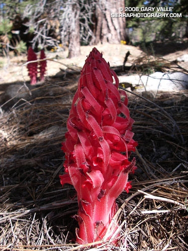
Snow Plant (Sarcodes sanguinea) is so different from the norm that each encounter is memorable. In a world where most plants are green, its startling red color and unusual structure always make an impact.

Snow plant pushing up through detritus.
Snow plant pushing up through the detritus on the forest floor.

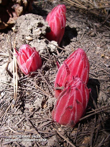
On Sunday, while running on the Tumamait Trail between Mts. Pinos and Abel, I had the opportunity to photograph Snow Plant in its early stages of above ground development. This revealed how the plant uses specialized bracts as armor while pushing up through detritus on the forest floor.

A bract is a modified leaf that is usually located near a flower, but differs in size and appearance from a normal leaf. A bract can be as simple as leaf that is reduced in size, or it can be modified to serve some other function, such as appearing to be a petal. On the Snow Plant they are relatively long, red strips that overlap and create a protective barrier as the bullet-shaped plant pushes to the surface.

Once fully erupted, the plant expands and the bracts unfurl to reveal the flowers. Over a period of a few days, the bracts continue to wither, fully exposing the flowers.

For additional snow plant photographs, see the posts Three Points – Mt. Waterman Loop and Snow Plant Still Life, and also Snow Plant on SierraPhotography.com.

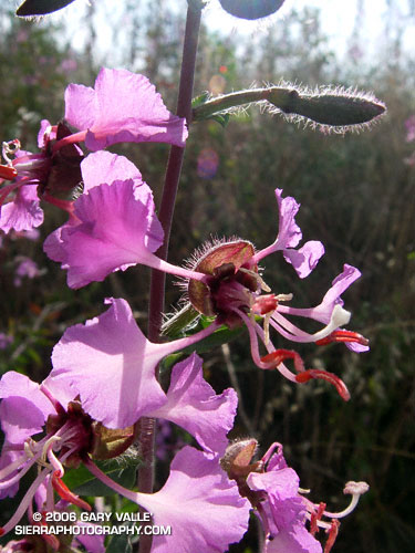
Related post: Pine Drops

Bee Fly On Western Wallflower


Bee Fly on a Western Wallflower (Erysimum capitatum).


The fuzzy critter with the beady eyes is a Bee Fly. Its darting, hummingbird-like movements caught my eye while running on the Tumamait Trail near Mt. Abel (Cerro Noroeste) on Sunday. It was feeding on a Western Wallflower (Erysimum capitatum). Fully consumed by the morning’s experiences, I had been marveling at the vibrant yellow of Wallflowers along the trail.


With only a cursory glance, someone might mistake a Bee Fly for a bee. It does buzz. But the resemblance is superficial. It is smaller than a Honey Bee, and more thick-bodied. It has long legs, and a long proboscis to collect nectar. These can be seen in the inset photographs.


Looking at these photographs it struck me that there probably is a relationship between the length of the Bee Fly’s proboscis, and the length of its legs. It can be seen in the photos that the Bee Fly uses its legs to grasp a plant while flying and feeding. This helps stabilize its flight, conserves energy, and enables a quick escape from a possible predator. It would seem that the legs have evolved to be just long enough to accomplish this task.

Vincent Tumamait Trail

Mt. Pinos from the Vincent Tumamait Trail

Mt. Pinos from the Vincent Tumamait Trail

There are several options for runs and hikes in the Mt. Pinos area. On the long side is the 25+ mile run from the lower McGill trailhead to Mt. Abel (Cerro Noroeste) mentioned in Snow Plant Still Life. Another valley-to-summit adventure is the approximately 20 mile out & back run/hike to the summit of Mt. Pinos from Three Falls Boy Scout Camp in Lockwood Valley.

This day I was looking to escape the heat of the San Fernando Valley, but do something a little less ambitious than either of those runs. The North Fork would be too hot, and McGill to Abel too strenuous. Instead, I opted for a third alternative, the Vincent Tumamait Trail between Mt. Pinos and Mt. Abel. By doing a short side trip to the spring at Sheep Camp, I could carry one water bottle and keep things simple.

The route, including the spur to Sheep Camp, works out to be about 14.5 miles, with 3000 ft. or so of elevation gain. There’s a lot of up and down as the trail works its way along the forested ridge, and past the broad summits of Sawmill Mountain and Grouse Mountain.  The trail ends at the Cerro Noroeste road, but it is not difficult to find a way up the steep slope above the road to the summit of Mt. Abel.

In kayaking there is saying that you “never run the same river twice.” The same is true of trails. Each experience on a particular trail is unique. This would be a day of unblemished blue skies and tired legs, the subtle scents of sun-warmed pine needles and Jeffry Pine on the air. A day of bounding deer, Paintbrush reds, and Wallflower yellows. It would be one to contemplate the fallen trees of Cerro Noroeste, the peculiar shape of the Larkspur leaf, the intricacies of the snow plant, and the hummingbird flight of the Bee Fly.

The photograph is a glimpse of Mt. Pinos from the saddle west of the peak. With sufficient snow cover, and the right conditions, I’ve enjoyed good skiing on these slopes, as well as along the ridge leading to Sawmill and Grouse Mountains. Here’s a view of Grouse Mountain from near Mt. Abel.

Here’s a Google Earth image and Google Earth KMZ file of a GPS trace of my route.

Old Santa Susana Stage Road

Old Santa Susana Stage Road

Running or hiking up the Old Santa Susana Stage Road, if you stop and listen carefully, you may hear a sharp whistle, a raspy shout, or a few choice expletives echoing from the canyon walls. It would have taken a barrage of such oaths, and a lot more, to get a stage up and over this harrowing grade.

The image of the Simi Pacific Coast Stage in the book Simi Valley: A Journey Through Time, helps to complete the mental picture. Steep, narrow, and unforgiving, the Stage Road must have produced stark terror in more than a few passengers.

Established in 1861, the “Devil’s Slide” stage road was a link in the Pacific Coast Stage Line between Los Angeles and San Francisco. It follows the route of the original Spanish trail connecting the San Fernando and Santa Buenaventura Missions. Prior to the arrival of the Spanish, the route is said to have been “an old Indian trail,” connecting Chumash communities in Simi Valley to Gabrielino communities in the San Fernando Valley.

Old Santa Susana Stage Road is located in Santa Susana Pass State Historic Park. The park was created in 1998 to protect the Stage Road and other cultural resources in the area. A General Plan characterizing the purpose and long-term vision for the park is in under development, and through a series of meetings, public input on the plan is being requested. The second such meeting is scheduled for Tuesday, June 20, 2006 at 8:30 P.M. at Chatsworth Park South. See the General Plan web page for additional details.

There is currently no “official” trail leading to the Stage Road. Since the area was burned in the Topanga Fire last Fall, it’s important to stay on existing dirt roads and trails to help promote recovery, and avoid damaging sensitive habitat or species.

(Photograph from a run on February 19, 2006.)

Elegant Clarkia

Elegant Clarkia (Clarkia unguiculata) is also known by the common name Farewell to Spring.

Elegant Clarkia (Clarkia unguiculata) is a showy, if somewhat bizarre looking, flower that blooms late in the Spring. It is also known by the common name woodland Clarkia. It adds a refreshing dash of color to the hills of Southern California, as they turn from green to golden brown. The plant appears to be an excellent indicator of Spring rainfall. In a drought year it might only be a foot tall, but in a rain season with a wet Spring, some stalks may reach 6 or 7 ft.

This photograph was taken near Laskey Mesa, on a run in Upper Las Virgenes Canyon Open Space Preserve (formerly Ahmanson Ranch).

Related post: Rain Gauge