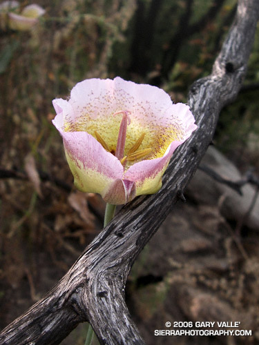
New Grass at Ahmanson Ranch Following the Topanga Fire

New sprouts of grass at Ahmanson Ranch less than a month after the Topanga wildfire burned 24,175 acres in the Simi Hills, northwest of Los Angeles.

New sprouts of grass at Ahmanson Ranch less than a month after the Topanga wildfire burned 24,175 acres in the Simi Hills, northwest of Los Angeles. More photos and information regarding the Topanga Fire can be found in my Coyote Oak Journal article The Topanga Fire, Part I: Rain, Wind and Fire. (Photo from October 25, 2005.)

Ferns Along the Garapito Trail

Ferns along the Garapito Trail, Topanga State Park.

Ferns along the Garapito Trail, Topanga State Park.

Chaparral has been described as an elfin forest, and there is probably no better trail in the Santa Monica Mountains to see why, than the Garapito Trail. From the fire road near Eagle Rock, the trail seemingly dives into a tunnel of chaparral, and doesn’t emerge until it ends at Temescal Fire Road, some 2.5 miles away.

This day I ran a 12 mile figure-eight course from the end of Reseda to Trippet Ranch via the Hub, and then returned via the Musch, Garapito, and Bent Arrow trails. Fire roads out– trails back. A shorter option goes directly to the Garapito Trail via the Hub, and then returns via the Bent Arrow trail. This is about 7.5 miles. A longer option tacks on an out and back to Parker Mesa at Trippet Ranch.

San Fernando Valley from Rocky Peak

San Fernando Valley from Rocky Peak

Updated May 3, 2008.

Whether it’s raining, 100 degrees, or snowing (!) you’re likely to see someone hiking, mountain-biking, or running Rocky Peak road in  Rocky Peak Park. Switchbacking up from the 118 freeway, the fire road climbs along the spine of the Santa Susana mountains. It’s proximity to the San Fernando and Simi Valleys, and array of route variations, make it the choice of many for a morning or afternoon workout.

It’s not because it’s easy — the route is steep from the start, gaining 500 ft. in the first three-quarters of a mile, and 1200 ft. in just over 2 miles.

Following are some approximate one-way distances and elevation gains.

Hummingbird Trail: 0.8 miles 500 ft.

High point at turnoff to peak: 2.4 miles 1200 ft.

Johnson Motorway: 3.2 miles 1350 ft.

Chumash Trail: 3.8 miles 1390 ft.

Fossils: 4.8 miles 1800 ft.

Las Llajas Loop turnoff: 5.5 miles 1950 ft.

End of Rocky Peak Rd at Las Llajas Cyn Rd.: 6.3 2070 ft.

Related posts: Chumash Trail Snow, Oat Mountain Snow, Sunset Snow Shower.

Google search: $g(Rocky Peak), $g(Hummingbird Trail), $g(Chumash Trail)

Photography and inspiration from running and other adventures in the Open Space and Wilderness areas of California, and beyond. No ads. All content, including photography, is Copyright © 2006-2024 Gary Valle. All Rights Reserved.