Arroyo Conejo, Wildwood Park and Elliot Mountain

Elliot Mountain with Lizard Head, Mountclef Ridge and Wildwood mesa in the distance

This morning’s run had started on the southern boundary of the Arroyo Conejo Open Space near Amgen in Thousand Oaks. It was 39°F at the beginning of the run and the chill of dawn and brisk north wind made it feel even colder. The plan was to run north on the Arroyo Conejo Trail and connect to the trails in Wildwood Park.

Gorge cut by Arroyo Conejo Creek

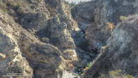
Running on automatic, and hoping to warm up quickly, I followed the Arroyo Conejo Trail north along the shoulder of the canyon. Known as “La Barranca” the three mile long canyon extends from the 101 Freeway to Hill Canyon near Santa Rosa Road. Rounding a corner and working up and over a little hill I looked to my right and was astonished to see that in this section of the canyon a deep, vertical-walled gorge had been cut into the residential landscape.

Mountclef Ridge from the Stagecoach Bluff Trail in Wildwood Park.

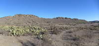
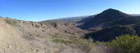
The wildness of the gorge set the tone for the remainder of the run. Arroyo Conejo, Wildwood Park and the Western Plateau have a scenic, desert southwest character all their own and an extensive trail system. If a bluff, peak or other feature looked interesting, there was generally a way to get to it. I ran along Stagecoach Bluff, then to Lizard Head, and then over to the Canyon Overlook Trail and down to the Conejo Canyons Bridge at the Hill Canyon trailhead.

Hill Canyon and Elliot Mountain from the Canyon Overlook Trail.

After running up Hill Canyon, I was once again headed uphill, this time on the Western Plateau Trail. I’d caught a glimpse of some mountain bikers high on the bluff above and couldn’t resist continuing. I had more than 10 miles in and was planning to go back through Wildwood Park. Each mile added now would add two miles to my growing round trip total.

Box Canyon and Mountclef Ridge from the Canyon Overlook Trail

That’s the difficult thing about doing an exploratory run — deciding where to turn around. You HAVE to see what’s around each corner and what the view is like from the top of every hill. You can’t turn around just anywhere, and I was looking for the right place.

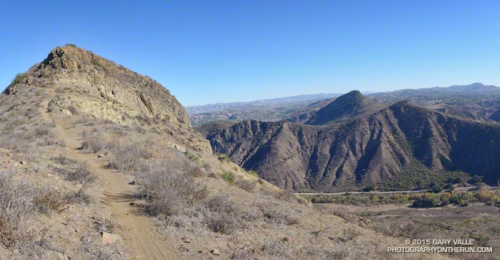
Turning onto the Outlaw/Gnome Trail, in a few minutes I reached the top of the rock outcrop where I’d seen the mountain bikers.  But it wasn’t the top of the climb, and it definitely wasn’t the right spot to turn around. A bit higher I could see a sign silhouetted on the skyline and was curious to see what it said.

Trail to Elliot Mountain in the Western Plateau area near Hill Canyon
Trail to Elliot Mountain

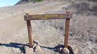
The sign read “Elliot Mountain Trail.” How could I turn around now? Continuing east, a newly cut trail with a bench en route led to the top of the peak. Recently named in honor of Burt Elliot, “a tireless volunteer, open space advocate and champion of trails,” the peak was the perfect place to spend a few minutes enjoying the great view and then start my circuitous trip back to the car.

For trail maps and more information see the Conejo Open Space Foundation web site.

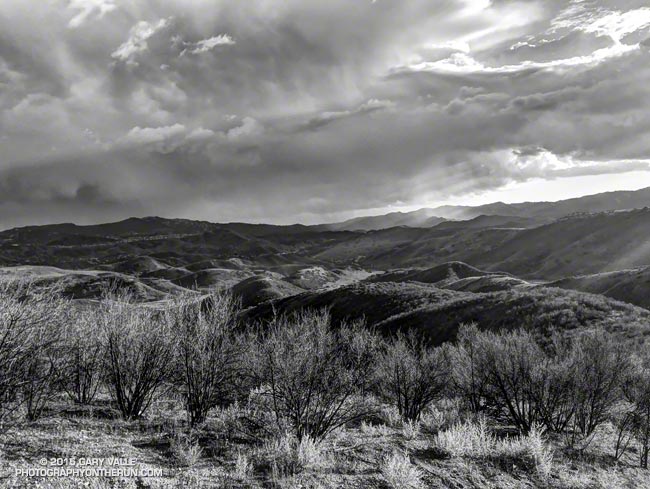
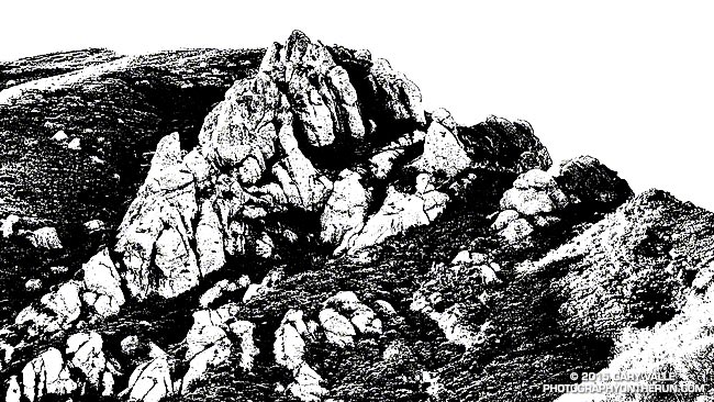
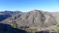
The title photograph is Elliot Mountain with Lizard Head, Mountclef Ridge and Wildwood mesa in the distance.

Longer Late Afternoon Runs

Sunset in open space area near Los Angeles

If you are a late afternoon runner and live in the Los Angeles area (or similar latitude), beginning December 11 the sunset time computed by the U.S. Naval Observatory increases from 4:44 PST to 4:45 PST. By the end of December sunset will be about 10 minutes later than today. It isn’t until July 5, 2016 that the computed sunset time begins to decrease.

Waiting for Rain: El Nino and the 2015-16 Southern California Rainfall Year

Thunderstorm over the Santa Monica Mountains

Due in part to El Nino and the Madden-Julian Oscillation (MJO) Southern California jump-started the 2015-16 rain season with above average rainfall in July and September.

Last year the NWS changed the WATER Year to October 1 – September 30, but the RAINFALL Year remains July 1 – June 30, as it’s been for decades.

Below is the monthly tabulation of rainfall for Downtown Los Angeles (USC) for the 2015-16 Rainfall Year, along with what is considered normal for the month.

Downtown Los Angeles Rainfall
Month Rainfall Normal
July 0.38 0.01
August T 0.04
September 2.39 0.24
October 0.45 0.66
November 0.01 1.04

So far this rainfall year Downtown Los Angeles (USC) has recorded 3.23 inches. Even with November as dry as it’s been we’re still more than an inch above normal for the rainfall year — about 1.46 inches above normal as of November 25.

Over the next couple of weeks the medium range models and other tools aren’t especially bullish on our chances for a good, soaking rainstorm in Southern California. Longer term guidance suggests an improving chance of precipitation as December progresses, and above average precipitation in January and February. We’ll see!

The title photo is from November 3. It shows a band of thunderstorms that moved southward across the San Fernando Valley and into the Santa Monica Mountains. The band produced cloud to ground lightning strikes and some heavy showers. Saddle Peak is in the distance on the left. The shower activity in the distance on the right is in the area of Kanan Rd. and the 101 Frwy.

Boney Mountain’s Western Ridge

Boney Mountain's Western Ridge

From today’s run, hike, scramble and climb of Boney Mountain’s Western Ridge. The rounded pinnacle at the  top of the formation is this one.

Some related posts: Boney Mountain Western Ridge & Loop, Over Boney Mountain to Sandstone Peak and Serrano Valley, Boney Mountain Eclipse Run, Boney Mountain – Serrano Valley Adventure Run, Boney Mountain Views

Photography and inspiration from running and other adventures in the Open Space and Wilderness areas of California, and beyond. No ads. All content, including photography, is Copyright © 2006-2024 Gary Valle. All Rights Reserved.