Mt. Waterman Pines & Clouds

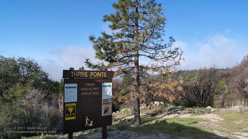
Last Sunday started with light rain in western Los Angeles County, and on the drive to the San Gabriel Mountains, I wondered if the Three Points trailhead would be above the mile deep cloud layer. It was, but barely so, and at the start of the run a couple of scuddy clouds hung over the parking lot.


These were soon left behind, and while the lowlands dealt with damp, dreary weather, my Easter morning run on the PCT continued toward Cloudburst Summit under a bright sun and mostly cloudless skies.

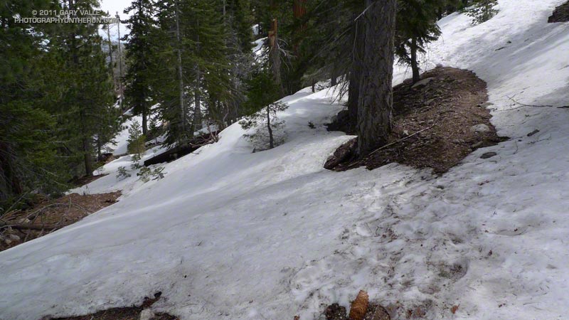
I encountered my first patch of snow a little past Camp Glenwood, on a shaded north-facing slope at about 6300′, nearly three miles into the run. With the above average snowpack, it would have been a surprise not to find some patchy lower elevation snow. Much more snow could be seen on the higher elevation slopes, and the big question was: how much snow would there be on the Mt. Waterman trail?

From Cloudburst Summit I continued eastward on the PCT to Cooper Canyon — one of the most idyllic places in the San Gabriel Mountains. Snowmelt had increased the streamflow, and to start the climb to Buckhorn, two creek crossings were required. It was cool enough that if I could avoid it, I didn’t want to soak my shoes. On the other hand I would rather have wet shoes, than fall bodily into a creek trying to keep them dry. A makeshift trekking pole helped prevent either scenario. Cooper Canyon Falls was spectacular.


On a Summer day this route can be quite warm, and I usually top off my Camelbak at Buckhorn Campground. Good thing it was a cool day — Buckhorn Campground was closed and the water in the campground was turned off. It looked like the Forest Service was doing a major revamp of the campground.

From the campground I still couldn’t tell if the Mt. Waterman trail was going to go. There was a lot of snow on the north-facing slopes, but I was betting it wasn’t going to be as choked with snow as it looked. Worst case, I could turn around, so I decided to continue until there was some reason not to.

There was some snow, and at one point I left the trail to avoid a particularly steep snow slope. About a mile from Hwy 2, the trail worked up onto a broad east-facing ridge, and from that point the trail was mostly free of snow.


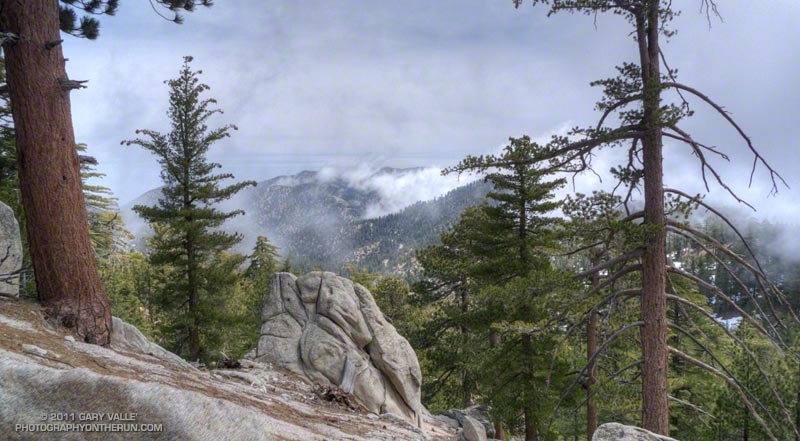
No sooner had the snow issue been resolved, when clouds began to spill over the ridges and increase overhead. I knew — or at least thought I knew — that other than decreasing the visibility and temperature, these clouds shouldn’t be a problem. Even so, I was very glad to know the terrain and route well, and have some additional gear in my pack.

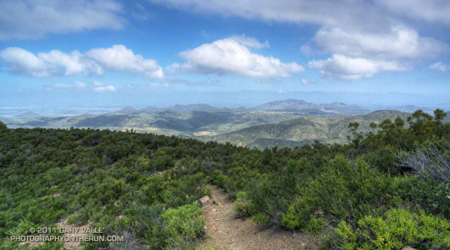
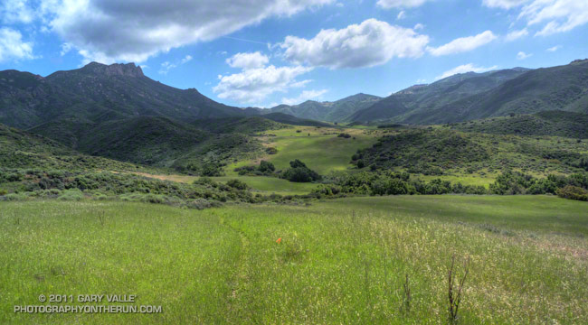
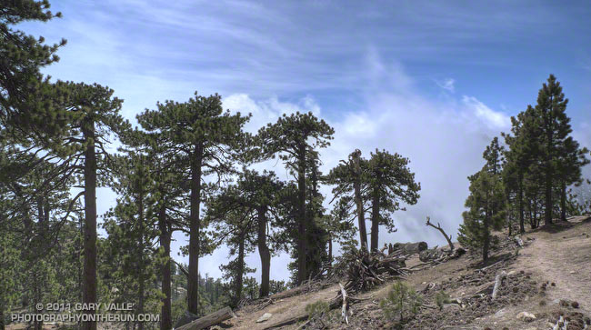
The title photograph is from the upper section of the Mt. Waterman trail. The clouds are in the deep canyon between east ridge of Waterman Mountain (8038′) and Twin Peaks (7761′).

Some related posts: Cooper Canyon Cascade & Falls, Manzanita Morning

Category Is: Things Found on the Chumash Trail

Things Found on the Chumash Trail

What the… Until I saw the water bottle and that the person was talking on a cell phone, I wasn’t sure what I was seeing.

Then there was the rattlesnake — well actually, the two rattlesnakes! Here’s an video snapshot of one of the rattlesnakes. This is an average size Southern Pacific rattlesnake. Because of our cool Spring weather they’ve been slow to appear, but are now out and about.

Some related posts: Big Southern Pacific Rattlesnake at Ahmanson Ranch, It was So Muddy That…, Overcoming Obstacles on the Trail

River Up for the 2011 Kern River Festival

Hooligan Boat - 2011 Kern River Festival

Big snow equals big water, and this year the Kern River snowpack was measured at nearly twice normal, jump-starting the paddling season and producing summer-level flows in mid April for the 2011 Kern River Festival.

Saturday, racers had great water for paddling the spectacular waterfalls, steep drops, and slides on Brush Creek; and Saturday afternoon at Riverside Park there was good coverage and splashy rapids for the second edition of the Hooligan Boat competition. Once again, the Hooligan boats were a spectator favorite.


Saturday night the Kern River flow increased from about 2250 cfs to 2800 cfs, and Sunday morning racers competing in the Tom Johnson Whitewater Slalom had the most water for the slalom in over 20 years. This resulted in some challenging moves on the fast moving river, and many paddlers had to go to “plan B” after getting pushed off line, coming in low on a gate, or blowing a ferry.

Speaking of hard moves, here’s a video snapshot of innovative kayak, surfboard and SUP designer Corran Addison (sans Mohawk) doing the difficult cross river move from gate #11 to gate #12, and then down through gates #13 and #14 on a SUP.

The 2012 Kern River Festival will be April 20-22 in Kernville, California.

Wow, What a Great Day for a Trail Run!

Ridge near summit of Tri Peaks

The Wendy Dr. trailhead in Newbury Park is a gateway to some of the most scenic and spectacular trail runs in the Santa Monica Mountains. Runs, hikes and rides on the extensive and diverse network of trails can range from a few minutes, to many miles and hours.

Today my run was of the “few hours” variety. The weather in Pt. Mugu State Park was perfect for a longer run — partly cloudy, light winds, and the temperatures ranged from the high 40s in the morning to the high 60s midday.

La Nina or El Nino, rain seasons as wet as the 2010-11 season are relatively rare. The wet weather produces a cascade of effects, resulting in conditions that might not be seen again for years. Streams that had not run for years were flowing; numerous wildflowers were blooming; the chaparral and other plant communities, and their inhabitants, were flourishing. I did not want to miss anything.

With that thought in mind, my route took me up and over Boney Mountain and Tri Peaks to the Backbone Trail, and then down the Chamberlain Trail and Old Boney Trail to the Serrano Valley Trail. After running through resplendent Serrano Valley, I continued down Serrano Canyon, crossing the creek 15 times, all the while trying to avoid the lush growth of poison oak along the trail. Even the miles returning up Sycamore Canyon were enjoyable, and involved a few stream crossings. The Upper Sycamore Trail and Danielson Road led back to Satwiwa and the trailhead.

On this particular day it was as fine a trail run as I have done, and probably the most scenic loop I’ve done in the Santa Monica Mountains.

Some related posts: Western Rim of Boney Mountain, Conejo Valley Sun and Boney Mountain Clouds

Here are a few additional photographs from the run:


Boney Mountain NW Ridge


Chamberlain Trail


Serrano Valley Loop Trail
                  
Fuchsia Flowered Gooseberry


Puffball


Hummingbird sage