Category Archives: mt pinos

Escape to Mt. Pinos – An Alternative to Closed Angeles Crest Highway Trailheads

Large Jeffrey pine and larkspur along the Vincent Tumamait Trail in the Chumash Wilderness.
Jeffrey pine and larkspur along the Vincent Tumamait Trail

A long stretch of Angeles Crest Highway (Highway 2) between Red Box and Vincent Gap remains closed because of storm damage. According to a tweet from Caltrans District 7, it sounds like it may be closed through Summer. Some affected trailheads include Shortcut Saddle, Three Points, Mt. Waterman, Buckhorn, Mt. Williamson, and Islip Saddle.

Starting down the Vincent Tumamait Trail, near the Condor Observation Site on Mt. Pinos.
Starting down the Vincent Tumamait Trail

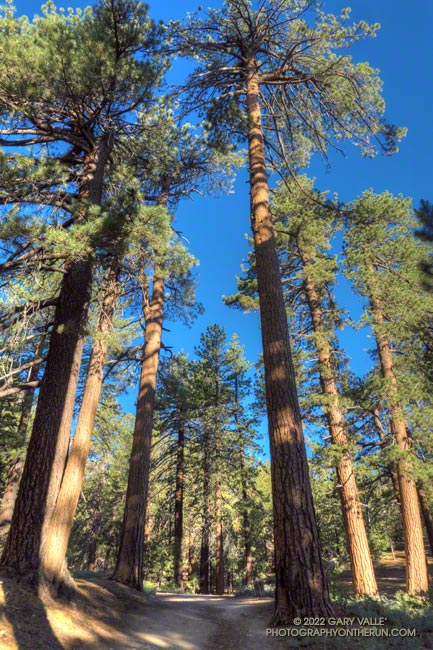
Mt. Pinos is often overlooked as a trail running destination but offers several options for those that enjoy running or hiking in hilly terrain at higher altitude. Most of the runs at Mt. Pinos start at the Chula Vista Trailhead (8350′) at the end of Mt. Pinos Road.

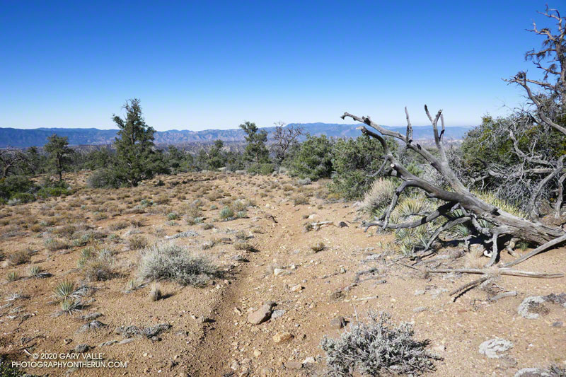
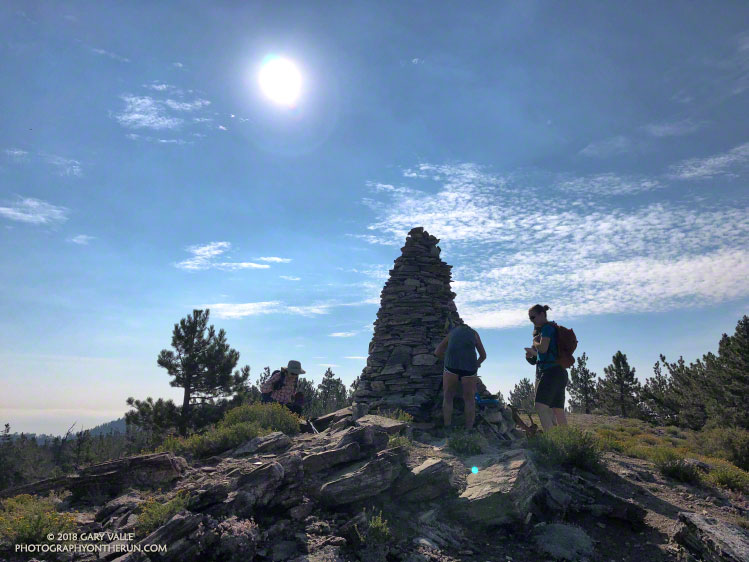
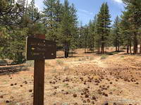
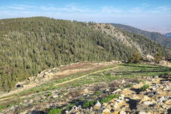
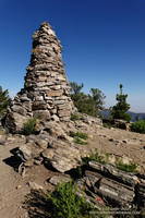
Today, I was doing an out-and-back from the Chula Vista Trailhead to Mt. Abel/Cerro Noroeste (8280+’). The route includes short side trips to Mt. Pinos (8831′), Sawmill Mountain (8818′), Grouse Mountain (8582′), and Sheep Camp (8300′).

Snow plant along the Vincent Tumamait Trail

Including the side trips, the run/hike is about 15.5 miles long, with about 3700′ of gain/loss. Google Earth calculates the average elevation of the route to be 8434′. In comparison, the average elevation of the out and back from Islip Saddle to Mt. Baden-Powell is 8201′.

With triple-digit highs expected in some low-elevation areas, the temps on Mt. Pinos today were ever so pleasant — short-sleeves from the start and only a little toasty in a few exposed areas.

Chumash spirit tower on Sawmill Mountain., west of Mt. Pinos.
Chumash spirit tower on Sawmill Mountain.

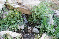
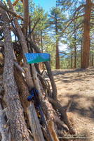
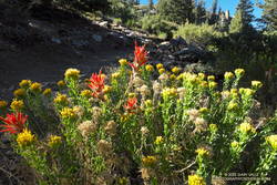
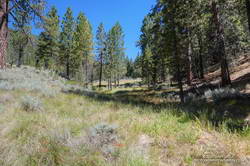
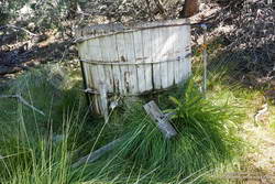
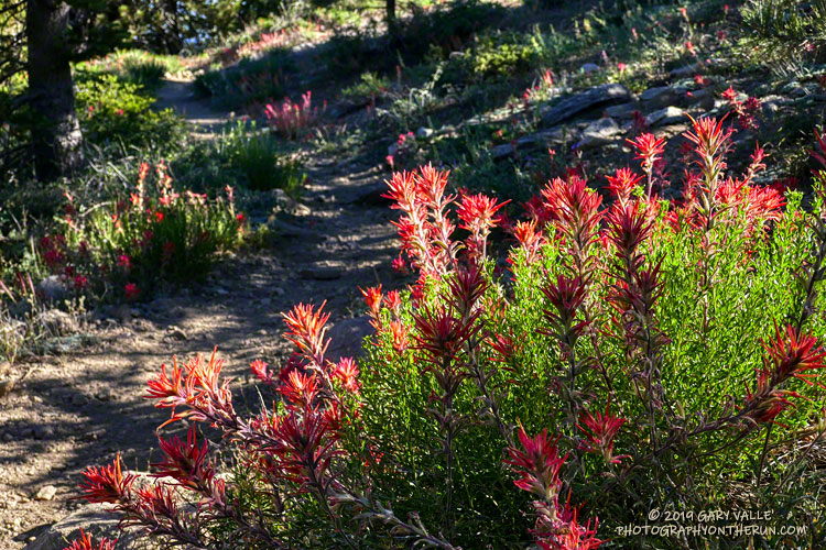
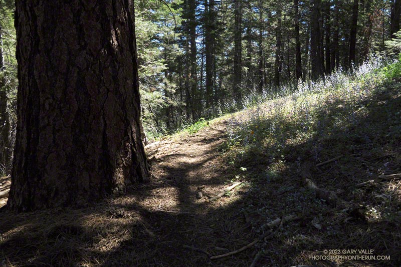
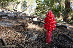
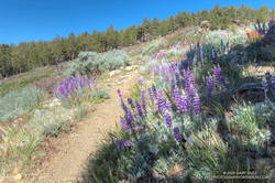
Despite the harsh Winter, there were only one or two small trees down on the Vincent Tumamait Trail, and those were inconsequential. As elsewhere in Southern California, the wildflowers along the trail were sensational. After nearly drying up last year, the spring at Sheep Camp was running at full flow.

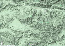
Explore the scenery and terrain of this out and back run from Mt. Pinos to Mt. Abel using our high resolution,  interactive, 3D viewer. The imagery is so detailed, it’s almost like being there! To change the view, use the control on the upper right side of the screen, the CTRL key and your mouse, or touch gestures. Track and placename locations are approximate and subject to errors. Snow, ice, poor weather, and other conditions may make this route unsuitable for this activity.

Lupine and other wildflowers along the Vincent Tumamait Trail, near Mt. Abel Road.
Lupine and other wildflowers along the trail, near Mt. Abel Road.

If you are looking to run longer, add additional elevation gain, or explore the area, running to Lily Meadows and back from Sheep Camp extends the run to about 21 miles, with around 5400′ of elevation gain/loss.

Another option for a longer run is doing an out-and-back to Mesa Spring Camp, instead of Mt. Abel. Including a stop at Sheep Camp on the way back, this run is about 20.5 miles, with about 4800′ of gain/loss.

Lily Meadows and Mesa Springs see far less traffic than the Vincent Tumamait Trail. The trade-off is that both places are at lower elevation and can be 15-20 degrees warmer than Mt. Pinos.

Some related posts:
Thirsty Mt. Pinos
Mt. Pinos to Mt. Abel Out & Back – Plus Sawmill Mountain, Grouse Mountain and Sheep Camp
Up, Down and Around on Mt. Pinos’ Tumamait and North Fork Trails
Mt. Pinos Adventure Run to Mesa Spring

Thirsty Mt. Pinos

Towering pines on Mt. Pinos, near the Chula Vista parking area.

A couple leaving the camp saw that I was trying to collect drips of water from the nearly dry spring. I told them I was OK, and had water in my pack — I was just using a makeshift cup to get a couple of mouthfuls of cool water from the slowly dripping spring.

I had stopped at Sheep Camp (8300′) in the Chumash Wilderness, in Los Padres National Forest. The day was warm and the spring at the camp is usually a refreshing stop on the way back to Mt. Pinos and the trailhead at the Chula Vista parking area. Earlier, I’d talked to a runner training for the Kodiak 100, and he’d mentioned that the spring was a key source of water for his dog.

Trying to collect a mouthful of water from the spring at Sheep Camp. July 2022.
Trying to collect a mouthful of water from the spring at Sheep Camp

In recent years water has sometimes been an issue at the Sheep Camp spring. In July 2018, six out of the past seven Rain Years had been dry, and the flow of the spring was just a trickle. But it had been enough to slowly refill my Camelbak (TM) and get me down to Lily Camp (6600′) and back. Not so today.

Even without the water, Sheep Camp is a pleasant and worthwhile detour. Old growth pines tower above and bright yellow sneezeweed and other flowers are sprinkled about the forest floor. In the Spring large patches of iris bloom in the damp areas.

Today, I was returning from Mt. Abel, after having done Mt. Pinos, Sawmill Mountain, and Grouse Mountain on the way to Mt. Abel from the Chula Vista parking area. Here is an elevation profile of the run/hike. The cumulative elevation gain on the 15.5 mile run is about 3700′.

North summit of Grouse Mountain, west of Mt. Pinos.
North summit of Grouse Mountain.

The short side trips to the summits of Mt. Pinos and Sawmill require almost no extra effort, and the view from Sawmill — if it’s not too smoky or hazy — is wide-ranging. Getting to the twin summits of Grouse takes a bit more work, but it’s fun to follow the short use trail up the south summit and then to wander through the pines to the slightly taller north summit.

The descent that follows — down the use trail from Grouse and then down the Vincent Tumamait Trail to Puerto del Suelo, drops about 1000′ in elevation over 1.6 miles. This, of course, must be repaid on the way back!

When you reach the road at the end of the Vincent Tumamait Trail, you might remark, “But there’s no trail to Abel!” And you would be correct. It’s fairly straightforward to trek up through the forest from the road, though care is required due to the debris from forestry work in the area.

Rabbitbrush and paintbrush along the Vincent Tumamait Trail, northwest of Mt. Pinos.

Here’s an interactive, 3D terrain view of the run/hike from Mt. Pinos to Mt. Abel, with side trips to Sawmill Mountain, Grouse Mountain and Sheep Camp. The map can be zoomed, tilted, rotated, and panned. To change the view, use the control on the upper right side of the screen. Track and placename locations are approximate and subject to errors. Poor weather, snow, ice, and other conditions may make this route unsuitable for this activity.

More photos and info can be found in the related posts and in this post from a 2019 run/hike of this route.

Some related posts: Mt. Pinos Adventure Run to Mesa Spring; Up, Down and Around on Mt. Pinos’ Tumamait and North Fork Trails; Thunderstorm

Mt. Pinos Adventure Run to Mesa Spring

Mesa Spring Trail near the top of San Emigdio Mesa
Mesa Spring Trail near the top of San Emigdio Mesa.

For many that enjoy the outdoors, there is an insatiable desire to go where we have not been, learn what we do not know, and discover what we have not experienced.

Each time I’ve done the out and back trail run from Mt. Pinos to Mt. Abel, I’ve been curious about the Mesa Spring Trail. The trail leaves the Tumamait Trail at Puerto del Suelo, a saddle about 0.6 mile east of Mt. Abel Road, and descends to a campsite at a spring on the margin of San Emigdio Mesa. The mesa is the large alluvial fan shown on this Google Terrain Map overview.

The Mesa Spring Trail is part of an old trail shown on the USGS 1903 Mt. Pinos topo map. The old trail was part of a route that connected the Cuyama River to the historic El Camino Viejo a Los Ángeles. It followed Dry Canyon, went over Puerto del Suelo, and to the valley that is now the Pine Mountain Club. Like so many trails, it must have evolved from a hunting and trade route.

Google Terrain map showing San Emigdio Mesa and my route from Mt. Pinos

The Mesa Spring Trail is usually accessed from the West Tumamait Trailhead on Mt. Abel Road. But it occurred to me that starting at the East Tumamait Trailhead on Mt. Pinos might be an enjoyable way to do a longer out and back run. The Mesa Spring Trail looked like it might be similar to the North Fork Trail — a little less used and a bit more remote.

I left the Chula Vista parking area a little before 7:00 a.m. and started chugging up the road to the East Tumamait Trailhead at the Mt. Pinos Condor Observation Site. I planned to skip the usual side trips to Sawmill and Grouse. The spring was at a much lower elevation, and I wanted to get there before the temperature sizzled.

Once on the Vincent Tumamait Trail, it took a little over an hour to reach the top of the Mesa Spring Trail. The junction is marked with a new sign and tree branches on the ground. It is about 5.7 miles from the Mt. Pinos parking area.

Plant communities change dramatically with elevation.
Plant communities change dramatically with elevation. This Jeffrey pine forest is at about 7000′.

The first couple of miles down from the junction, the trail more or less follows the drainage. About 10 minutes from the junction, a large pine tree had fallen and completely blocked the trail. I worked around the right (west) side of the tree, where some orange fence posts had been placed. A few minutes beyond the collapsed tree, the trail wandered around the right side of a pretty meadow and then back to the “V” of the dry stream.

For the next mile or so, the trail followed a typical down-canyon route. On the way down, there were some spots where I stopped, turned around, and made a mental note of what the trail did. It wasn’t so much a matter of getting lost, as it was not wasting time at an ambiguous spot on the way back.

About 2.3 miles down from the saddle, the trail climbed out of the canyon, taking a counterintuitive turn to the right. After reaching a ridgeline, the trail turned back left and continued downhill. But its wanderings were not over. The trail was working across the gullies at the top of the San Emigdio Mesa. It went up, down, and around, but eventually did go to Mesa Spring. There were “ducks” marking the route, but it really helped to have looked at a map and have a general idea of where the trail would go.

Mesa Spring is on the northern margin of San Emigdio Mesa.

Mesa Spring is a pretty green spot in a group of pinyon pines. As I neared the spring, I saw some coyote-like ears bobbing through the sagebrush, and not long after that, a deer bounded through the trees. At the spring, a squirrel leaped from the edge of the water-filled cistern to a nearby tree and various birds flittered in the pines. I heard a trickle of water near the cistern’s base but planned to get water at Sheep Camp, later in the run.

With its bounty of pinyon pine nuts, acorns, juniper berries, game, and more, San Emigdio Mesa provided vital resources for the local Chumash.

Although the Mesa Spring Trail continues down the mesa, the spring was my turnaround point. I had waited for a day when the weather was better for this run. A weak low-pressure trough moving through to the north had stirred up a little wind and taken the edge off the recent heatwave. It had been cool on the crest, but at 6000′ it was already hot in the sun. It was time to get moving, and in a few minutes, I was retracing my steps and headed back to Mt. Pinos.

With a stop at Sheep Camp, the run & hike worked out to about 20 miles, with an elevation gain of around 4700′. Here are a few photos taken along the way, and an interactive 3D view of the trail run.

Some related posts: Mt. Pinos to Mt. Abel Out & Back – Plus Sawmill Mountain, Grouse Mountain and Sheep Camp, Up, Down and Around on Mt. Pinos’ Tumamait and North Fork Trails

Mt. Pinos to Mt. Abel Out & Back – Plus Sawmill Mountain, Grouse Mountain and Sheep Camp

Paintbrush along the Vincent Tumamait Trail near Mt. Pinos.

The out and back trail run from the Chula Vista parking area on Mt. Pinos to Mt. Abel (Cerro Noroeste) is a long-time favorite. It combines subalpine summits, beautiful pine and fir forests, and a unique flora with uncrowded trails that are fun to run and explore.

The basic out and back to Mt. Abel (Cerro Noroeste) with a stop on the way back at Sheep Camp for water is around 14 miles with an elevation gain/loss of about 3400′. The side trips to Sawmill Mountain and Grouse Mountain are short and add about 0.75 mile to the distance and around 250′ to the elevation gain.

As in other areas of Southern California, the wet 2018-19 Winter has resulted in an abundance of wildflowers in the Mt. Pinos region. Paintbrush, mariposa lily, larkspur, penstemon, lupine, phlox, iris, yarrow and many other plants are blooming in profusion. Limber pines in the area are full of cones and the spring at Sheep Camp is flowing well.

Floras and checklists for Mt. Pinos have been compiled by Tom Chester, CalFlora, Mount Pinos Ranger District, David L. Magney and others.

Here is a Juicebox album of a few photos taken on this trail run on Mt. Pinos.

Some related posts: Up, Down and Around on Mt. Pinos’ Tumamait and North Fork Trails, Thunderstorm, Pinos to Abel Plus

Up, Down and Around on Mt. Pinos’ Tumamait and North Fork Trails

A Chumash spirit tower on Sawmill Mountain, near Mt. Pinos

Yellows, reds and greens marked its location, but the seep above Sheep Camp was dry. As I approached the camp, the uppermost campsite was empty and I wondered if the spring at the camp was also going to be dry. If it was, I was going to have to revise my running plan.

Rabbitbrush blooming along the Tumamait Trail near its eastern trailhead on Mt. Pinos.
Near the start of the Tumamait Trail on Mt. Pinos.

So far the run had gone well. From the Chula Vista parking area (8350′), I’d run the service road up to Mt. Pinos (8831′), then followed the Tumamait Trail west to Mt. Abel Road. Along the way Sawmill Mountain (8818′)and Grouse Mountain (8582′) had been short side trips; and from the end of the trail, the summit of Mt. Abel (8280′) was a short hike up through the pines.

Compared to the triple-digit temperatures in the parched West Valley — as high as 117 °F this July — the temps on the Tumamait Trail had been wonderfully cool. The hotter than average weather seems to have become the new norm, and also — unfortunately — the resulting wildfires.

On a run here Last July, smoke from a fire near Lake Cachuma had nearly enveloped Mt. Pinos. Today several fires were burning in California, and once again smoke could be seen in the valleys and canyons to the north of the mountain.

The North Fork Trail and small spring at Sheep Camp.
The small spring at Sheep Camp.

To get in a bit more mileage and elevation gain the next part of my run was supposed to be an out and back to the sun-baked environs of Lily Meadows (6600′). That wasn’t going to happen if the spring was dry.

When I stopped at the wildflower-accented spring I could see that there was the barest thread of water trickling from the pipe. It didn’t look like much, but it filled my 18 oz. cut-off water bottle in about three minutes. I gulped down most of the first bottle and it took a couple more to fill my Camelbak. In about 10 minutes I was headed downhill.

The North Fork Trail at Lily Meadows Camp.

The North Fork Trail is far less used than the Tumamait Trail. That’s part of the fun. Thunderstorms had not only wiped away any previous tracks, but had severely eroded some sections of the trail as well.

With the loss of elevation came an increase in temperature. By the time I reached Lily Meadows Camp the temp was in the 90s. This time of year there were no lilies or meadows at the campsite, but there was a nice grove of Jeffrey pines and a new camp table!

I didn’t spend much time down there. There was a hill to climb and the cool temps along the crest were only about an hour away.

Some related posts: Pinos to Abel Plus, Thunderstorm, Vincent Tumamait Trail