
It was near dawn, and I was driving west on the 101 Freeway, going to the Wendy Drive Trailhead to do a run in Pt. Mugu State Park.
I’d just passed Moorpark Road and changed lanes to exit at Lynn Road. Suddenly, the whole car started to shake. The vibration was so intense it took a moment to realize I had a flat tire. [Expletive deleted!] I pulled onto the shoulder of the freeway and cursed again.
After decades without a flat, I had managed to have two in just three weeks. Both were early on Sunday morning and on the way to do a run. The first happened on Angeles Forest Highway while driving to Islip Saddle. That time, I was able to pull into a large turnout and change the tire. Traffic wasn’t an issue. Not so on the Ventura Freeway. The flat was on the driver’s side, and the shoulder was narrow. I called for service.
Apparently, there aren’t many roadside service vehicles out and about before sunrise on a Sunday. An hour and a half later, I was finally headed back to the San Fernando Valley.
I was first in line when Tires Buy Mark opened at 10:00. While waiting for the tire to be patched, I debated a Plan B for a run. Eventually, I decided to do an extended version of the Bulldog Loop. The run would be in the middle of the day, which wasn’t ideal, but it was nearby. It would be an excellent 16-mile run, even if a little on the toasty side.
At 11:30, I started up the short hill at the beginning of the Cistern Trail. Even though it wasn’t an unusually hot day, the temperature in the sun was already in the 90s, and there wasn’t a cloud in the sky.
It was slightly cooler on the trail along Malibu Creek. There was still water pooled in the creek, and I was glad the seasonal footbridge was in place. A pool near the M*A*S*H site was surprisingly large.
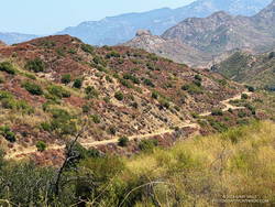
I expected it to be warm on the Bulldog climb, and it was. I just pretended I was on the second loop of the Bulldog 50K and continued chugging up the hill. Speaking of which… The Bulldog Ultra was the previous weekend, and a new course record was set in the 50K. Anthony Fagundes did the 29 mile course in the remarkable time of 3:30:03. This works out to an AVERAGE pace of 7:15 min/mile! His race analysis on Strava lists a split on the downhill on Mesa Peak Mtwy fire road at 5:25 min/mile. I don’t have the exact time, but on the first loop it looks like he did the Bulldog climb — from Crags Rd. to Castro Crest Mtwy — in about 30 minutes.
It took me a little longer than that to get up Bulldog. There was a noticeable drop in temperature as I worked up to the top of the long climb. On Castro Crest and Mesa Peak fire roads, the temperature was a relatively comfortable 80-something. The breeze from the ocean was intermittent, but when present, felt like air conditioning.
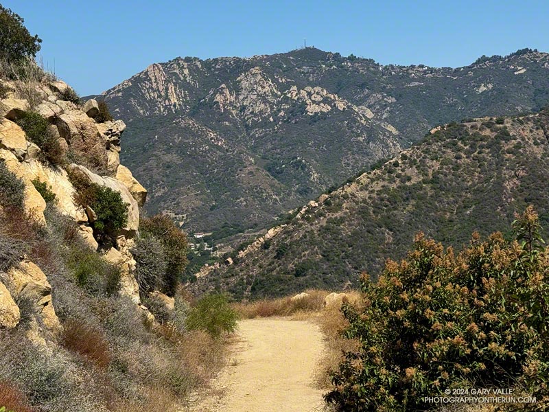
There weren’t many wildflowers. One interesting exception was Santa Susana tarweed (Deinandra minthornii). It was blooming on the sandstone rocks where the Backbone Trail goes through a prominent rock gateway, east of the Corral Canyon Trailhead.
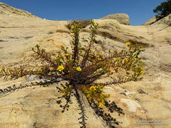
The plant has a California Rare Plant Rank of 1B.2, which means it is considered “rare, threatened, or endangered in California and elsewhere…” The plant normally blooms after Winter rains. In the ANF technical notes** accompanying its description on SMMflowers.org, B. A. Prigge & A. C. Gibson describe how the plant may produce out-of-season flowers in the Summer, following a wet rain season with late Spring precipitation.
Here is an interactive, high-resolution, 3D terrain view of a variation of the Bulldog Loop that starts at the Cistern Trail. The notations assume the route is being done counterclockwise. An optional out-and-back on the Forest Trail is shown as a red track. Two routes are shown for crossing Malibu Creek in Tapia Park. One route uses a trail that rock-hops across the creek, and the other the bridge on Malibu Canyon Road, near the Piuma Road junction.
The option on Malibu Canyon Road requires crossing the highway twice. There is a pedestrian walkway on the east side of the bridge and a traffic light and crosswalk at Piuma Road. The trail that crosses the creek directly can be a little tricky to find because of other use trails in the area. When there is heavy rain, the flow may be too high to cross the creek safely.
Today, I decided to use the highway. There was a never-ending line of cars headed to and from the beach. It probably would have been faster — and safer — to use the trail. After crossing the creek on the highway bridge, and before doing the climb on the Tapia Spur Trail, I topped off my water at a faucet in the Tapia Day Use Area. Later, I also grabbed a quick drink at the water faucet next to the restrooms at the main Malibu Creek State Park parking lot.
From the main parking lot, it’s about 1.4 miles along Crags Road to the bottom of the Lookout Trail, and from there another three-quarters of a mile back to the Cistern Trailhead on Mulholland Highway.
Some related posts:
– A Displaced Bridge, Exceptional Backbone Trail Views, and a Card Table Along the Bulldog Loop
– Forest Run
– Best Trailhead to Start the Bulldog Loop?
– Bulldog Loop Plus the Phantom Loop
**A Naturalist’s Flora of the Santa Monica Mountains and Simi Hills, California by Barry A. Prigge and Arthur C. Gibson