Category Archives: running|adventures

Excursion to Ross Mountain

Ross Mountain on South Ridge of Mt. Baden-Powell.
South Ridge of Mt. Baden-Powell, with Ross Mountain at its end.

Nearly every time I’ve climbed Mt. Baden-Powell I’ve wondered about the long ridge extending south from its summit. And nearly every time I’ve summited Baden-Powell I’ve been in the middle of another running adventure, and unable to explore more than a few hundred yards down the ridge. But today I wasn’t running to Eagles Roost or doing a long loop from Islip Saddle. Today the plan was to climb Ross Mountain, a peak far down on Mt. Baden Powell’s south ridge.

Ross Mountain
Ross Mountain

Major mountain ridges are often isolated, aesthetic and adventurous — characteristics that are magnets to mountaineers. While not technically difficult, the excursion to Ross Mountain is demanding. The first step is to climb Baden-Powell — a four mile trek with 2800′ of gain, that tops out at an elevation of about 9400′. From the top of Baden-Powell a use trail then leads down the south ridge three miles over varied terrain to Ross Mountain.

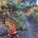
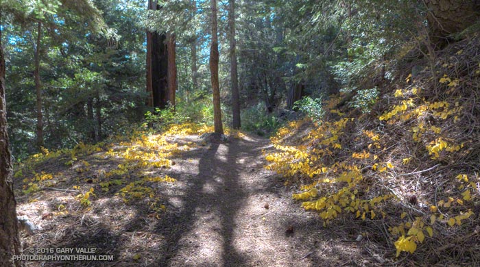
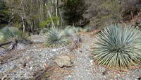
For the most part the use trail is relatively distinct and follows the anticipated route down the ridge. Even so, it is usually not as easy to follow a use trail as it is a conventional trail. It had rained a few days before, and the tracks of the last group to do Ross were vague. The most distinct tracks on the trail were from the recent passage of a bighorn sheep.

Bench on Mt. Baden-Powell's South Ridge.
Bench on Mt. Baden-Powell’s South Ridge.

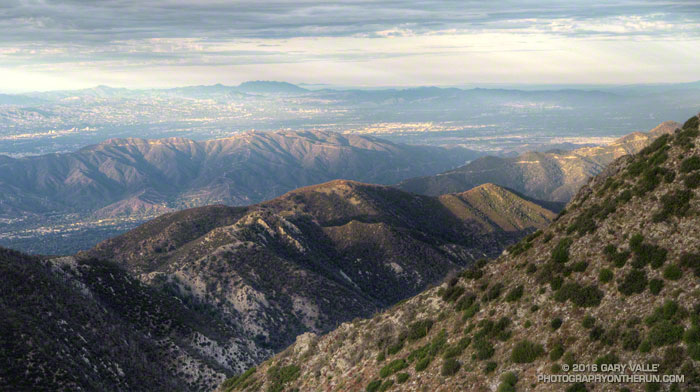
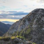
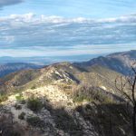
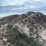
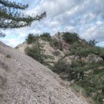
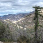
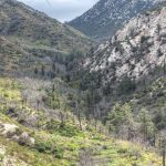
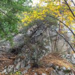
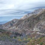
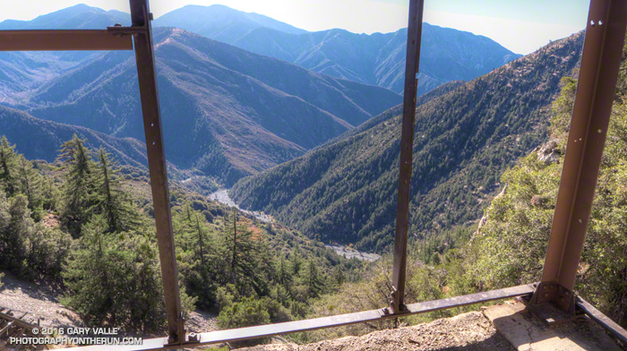
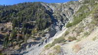
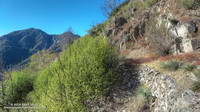
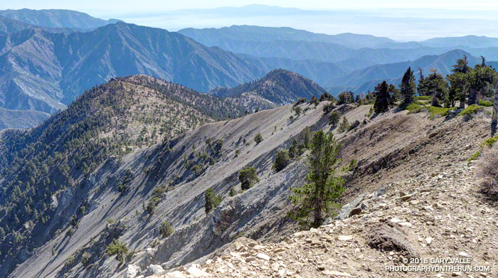
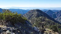
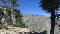
The route to Ross drops 2100′ in 2.5 miles, then ascends 200′ over the remaining half-mile to the peak. The descent is not continuous. About a mile from Baden-Powell the ridge is interrupted by a large bench, and there are other ups and downs along the way. The ridge can be seen in profile in this image or the PhotographyontheRun masthead.

Pine Mountain, Dawson Peak, Mt. Baldy, Ontario Peak, Iron Mountain and Santiago Peak.

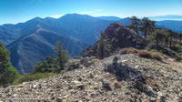
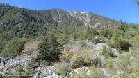
The ridge projects into one of the more rugged areas of the San Gabriel Mountains — the Sheep Mountain Wilderness. To the west is the deep canyon of the East Fork, with Pine Mountain, Dawson Peak, Mt. Baldy and Iron Mountain towering above. To the west is the very remote canyon of the Iron Fork, sweeping up to form the 9000′ crest between Throop Peak and Mt. Burnham.

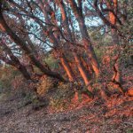
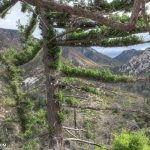
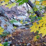
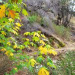
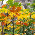
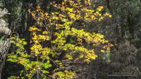
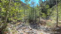
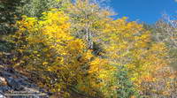
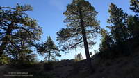
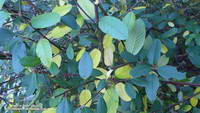
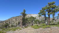
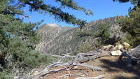
The ridge hosts a wide variety of conifers — limber pine, lodgepole pine, white fir, sugar pine, Jeffrey pine and even a few incense cedars. Life on the ridge is tough, and many of the trees are contorted, broken or stunted. It appears to have been a good year for the sugar pines, and some were heavily laden with cones. Overall the health of the trees on the ridge appeared to be good, with surprisingly few trees in obvious distress from the drought.

Mt. Baden-Powell from Ross Mountain.

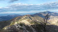
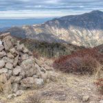
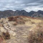
A little more than three hours after leaving Vincent Gap I zig-zagged up the final few steep steps to the 7402′ summit of Ross Mountain. Not unlike other vantage points along the ridge, the summit was a pretty spot under a sugar pine tree, but in this case with a small cairn and rain-soaked summit register.

After procrastinating a bit and checking out the south side of Ross Mountain’s elongated summit, I began the journey back to Baden-Powell.

Complex geology at head of Mine Gulch on Mt. Baden-Powell.
Complex geology at head of Mine Gulch.

Surprisingly, considering my plodding pace coming back up the ridge, it took almost exactly the same amount of time to get back to Vincent Gap as it had to go to Ross Mountain. As it worked out, the time lost on the climb back up the ridge was offset by the superb run down the Baden-Powell Trail.

According to my Garmin fenix 3’s barometric altimeter the total gain/loss on this adventure was about 5100′. If the gain/loss is calculated from the GPS track using 1/3 arc-sec DEMs it works out to about 5400′. The round trip distance was 14 miles.

Related post: Return to Ross Mountain

Red Box – Bear Canyon Loop Plus Brown Mountain

Brown Mountain, Verdugo Mountains and Boney Mountain in the distance.

This photograph of Jason and Owen Brown (Los Angeles Public Library, Security Pacific National Bank Collection) is cataloged with the following description:

Jason and Owen Brown (1884). Photo: Los Angeles Public LIbrary

“Photo of Jason and Owen Brown, sons of John Brown of the Civil War and Abolition fame. View shows Jason and Owen Brown sitting on Mount Wilson, near the site of their cabin in 1884.”

Is the reference to Mt. Wilson accurate? Probably not. The peaks in the background establish they are not on top of Mt. Wilson. While they might be elsewhere on the mountain, it doesn’t seem likely. Mt. Wilson is more than five miles from their El Prieto cabin site. In his guidebook Trails of the Angeles, John Robinson describes the photo of the Browns as being “on Brown Mountain” — a peak which is near their El Prieto cabin, and which figured prominently in their lives.

Not having climbed Brown Mountain, I was curious to see if the photo of the “Brown Boys”  was taken on or near its summit. Early this morning I set off from Red Box, Brown Boys photo in my pack, to do a loop through Bear Canyon and Arroyo Seco, and take a side trip to Brown Mountain along the way.

False summits leading to Brown Mountain

The detour to Brown Mountain began at Tom Sloan Saddle and followed the peak’s east ridge over several false summits to the summit of the peak. Brown Mountain’s rounded summit sits on the divide between Bear and Millard Canyons and on a clear day affords a panoramic view of the surrounding mountains and much of the Los Angeles area. Big views can lead to big dreams, and according to an article in the Los Angeles Herald in October 1896, the Boys had planned to build an observatory on the peak. While this was not built, the Boys did succeed in having the peak named in honor of their father

On the summit, and with the Brown Boy’s photo in hand, I faced first north over Bear Canyon, then east toward Mt. Disappointment, San Gabriel Peak and Mt. Markham; and finally south over Millard Canyon. Neither the terrain or skyline matched the photograph.

The best match I’d found today was on a peaklet near Tom Sloan Saddle looking southeast toward Inspiration Point.  More likely the photo was taken on a ridge closer to their cabin. That adventure would have to wait for another day.  Today the clock was ticking and I needed to retrace my steps back to Tom Sloan Saddle, descend Bear Canyon and then follow the Gabrieleno Trail up Arroyo Seco and back to Red Box.

Some related posts: Bear Canyon Loop Plus Strawberry PeakRed Box – Bear Canyon Loop,  Arroyo Seco Sedimentation

Following are a few photos taken along the way. Click a tile for a larger image and additional information.

Vincent Gulch and the Mine Gulch Trail

Mine Gulch Trail near Vincent Gap

Nearly back to Vincent Gap after visiting Big Horn Mine, I debated whether to run part way down Vincent Gulch on the Mine Gulch Trail. The Mine Gulch Trail leads to the confluence of Vincent Gulch, Prairie Fork, and Mine Gulch on the headwaters of the East Fork San Gabriel River.

The only reason I was hesitant was that hunters might not expect anyone else to be down in the isolated canyon. On the way out to Big Horn Mine I’d encountered a couple of hunters and heard the occasional report of a deer rifle down in Vincent Gulch. After my experience in Colby Canyon the previous Saturday, I hoped my neon-yellow-green Mt. Disappointment 50K shirt would help make me more visible.

Hiking up the East Fork to kayak from the Bridge to Nowhere.

I’d wanted to check out the Mine Gulch Trail for a long time. Back before the drought, when rainy season storms would sometimes rejuvenate the streams of Southern California, the West and East Forks of the San Gabriel River were a local alternative to the three hour drive up to kayak the Kern River. My kayaking partner Gary Gunder, myself and other local kayakers had paddled as high on the East Fork as the Bridge to Nowhere. In 2003 Gary kayaked the upper East Fork from the Iron Fork. We’d done a lot of hiking with our kayaks and we began to wonder if it might make more sense to hike down the Mine Gulch Trail from Vincent Gap, rather than hiking up the East Fork.

Bigleaf maple along the Mine Gulch Trail.

Reaching the well-marked trail junction a quarter-mile from Vincent Gap, I turned down the Mine Gulch Trail. I was finally going to see what the trail was like!

I had been expecting the Mine Gulch Trail to be a rough, overgrown and little-used path. After crossing an area stripped of trees by sporadic debris flows and avalanches, I was stunned to be running in an idyllic forest of pine, fir and oak on a wide, needle-covered trail bordered with golden leaves of snowberry.

Tom Vincent's cabin in Vincent Gulch.
Tom Vincent’s cabin in Vincent Gulch.

Continuing to descend, the trail passed near Tom Vincent’s cabin site and then a mile or so from Vincent Gap started a series of long switchbacks. A couple of switchbacks down, at an elevation of about 5900′, was a small stand of ponderosa pines. Ponderosa pines are less common in the San Gabriels than the similar Jeffrey pine, but can usually be distinguished by their smaller cones. The trees had drawn my attention because one of them was especially drought-stressed.

Vincent Gulch and Mt. Baden-Powell from the Mine Gulch Trail.
Vincent Gulch and Mt. Baden-Powell

Below the switchbacks and about two miles from Vincent Gap, the trail crosses a stream bed. The seems to be a spot where many hikers turn around. The trail sees less use beyond this point, and as it descends the east side of the gulch it becomes increasingly adventurous and isolated.

About three miles in I encountered a group of four hunters hiking up the trail. They were a bit surprised to see someone running down the trail and asked if I knew about a “flat” area down the trail. Now I realize they must have been referring to Cabin Flat, which was some distance and much bushwhacking away.

Mine Gulch Trail low in Vincent Gulch.

After encountering the hunters, the trail became less distinct and more disconnected. The “good” sections of trail were relatively long and the game became to piece together the sections of old trail, rather than traipsing through the rubble of the ravine. Intending to be back at Vincent Gap by about 1:00, I continued working down the gulch about another 30 minutes and finally turned around about a half-mile before the Prairie Fork junction.

Terrain in lower Vincent Gulch.
Where’s the trail?

Having just solved the main trail-finding puzzles on the way down, the ascent of the gulch was relatively fast and took about as much time as the descent. Part way up the switchbacks I caught up to the hunting group on their way out. They joked around, asking what my “secret” was. I told them I’d still be down in the canyon if I was loaded down with the 50-60 pounds of gear they were carrying.

Running down the Manzanita Trail, then over to Big Horn Mine, and then down the Mine Gulch Trail had been an enjoyable stream of thought adventure. I’d found Icy Springs was still running and learned more about the geology and history of the San Gabriels. While I probably wouldn’t be carrying my kayak down Vincent Gulch, becoming familiar with the trail did open the door to other adventures.

Big Horn Mine Trail

View from Big Horn Mine of Mine Gulch and the headwaters of the East Fork San Gabriel River.
View down Mine Gulch from Big Horn Mine. Mt. Baldy in the distance.

Returning from the run on the Manzanita Trail, I crossed Highway 2, stopped briefly at the car to switch packs, walked over to the gate in the southwest corner of the Vincent Gap parking lot, and began to run down the old road that leads to Big Horn Mine.

Mill buildings of the Big Horn Mine
Big Horn Mine mill building. Click for larger image.

Like the sure-footed animal for which it is named, the Big Horn Mine stands comfortably in a precarious spot on the east flank of Mt. Baden-Powell high above Mine Gulch and the headwaters of the East Fork San Gabriel River.

Gold hues of big leaf maple along the Big Horn Mine Trail.
Gold hues of big leaf maple along the Big Horn Mine Trail. Click for larger image.

Most accounts of the discovery of the mine describe mountain man Tom Vincent’s relentless search for the gold lode that was the source of the rich placer deposits of Eldoradoville and other workings along the East Fork. The story goes Vincent was out hunting for bighorn sheep when he made the discovery in 1895. This page from USGS Geological Survey Bulletin 1506-A-E lists mineral production for the Big Horn Mine and several other mines in the San Gabriels.

Big Horn Mine Trail about a mile from Vincent Gap.
Big Horn Mine Trail. Click for larger image.

The route to the mine follows an old roadbed and is generally straightforward. About 0.2 mile from the parking lot there is a big sign where the Mine Gulch Trail splits off (left) from the Big Horn Mine Trail and descends Vincent Gulch. About a mile from the trailhead the trail to the mine crosses a rough section where flash floods and debris flows have destroyed the road. Over the next mile the road gains about 400′ in elevation, ending at the mine’s mill building at about 6900′.

The mine was purchased by the Forest Service in November 2011.

Manzanita Trail Morning

Trees silhouetted by the early morning sun on a ridge above the Manzanita Trail.

Many of the hikers and runners that park at Vincent Gap climb Mt. Baden-Powell via the Pacific Crest Trail. The PCT isn’t the only trail that can accessed here and Mt. Baden-Powell isn’t the only hike. Vincent Gap is also the trailhead for the Manzanita Trail, Big Horn Mine Trail and Mine Gulch Trail. My run today involved these three trails.

Morning sun on trees at Vincent Gap from the Manzanita Trail
Morning sun on trees at Vincent Gap

First up this morning was the Manzanita Trail. The trail is part of the High Desert National Recreation Trail and connects Vincent Gap to South Fork Campground. It’s about 5.5 miles long and can be done as an out and back or as part of an approximately 23.5 mile loop that joins Islip Saddle, South Fork Campground, Vincent Gap and Mt. Baden-Powell.

Western chokecherry (Western choke cherry) along the Manzanita Trail.
Western chokecherry along the Manzanita Trail.

That loop is a favorite and this morning’s short run on the Manzanita Trail was to check if a small stream/spring I use as a water source was still running. Remarkably it was!

Some work had been done on the trail since I was there in June. A washed out section just below Vincent Gap had been repaired, the tread in several places improved, and the indistinct trail across the rocky wash about a mile down from Vincent Gap had been much improved.

Some related posts: South Fork AdventureTrail Running Weather, San Gabriel Mountains Running Adventure, Islip Saddle – Mt. Baden-Powell South Fork Loop

Plan B: Barley Flats

Pines and pine seedlings at Barley Flats

Nearing the junction I debated what to do — turn left on a well-used trail and climb Strawberry Peak or continue straight on an abandoned, overgrown road and go to Barley Flats? If I continued on the road it would be my second bush-whacking adventure of the day. Earlier, I’d abandoned an exploration in upper Colby Canyon when frequent rifle fire made the canyon feel confined and dangerous. This adventure was my plan B.

Overgrown Forest Service fire road connecting Red Box and Barley Flats, built in 1926.
Overgrown Forest Service fire road built in 1926.

Each time I’ve done Strawberry Peak from Red Box I’ve wondered about that overgrown old road. In the book The San Gabriels, John Robinson mentions that it was a Forest Service fire road built in 1926. It’s shown on the USGS 1934 Mt. Lowe and Mt. Wilson Advance Sheets connecting Red Box Gap and Barley Flats and then continuing to Charlton Flats, Chilao and the high country. Back then Angeles Crest Highway didn’t go to Shortcut Saddle, it turned at Red Box and went to the top of Mt. Wilson.

At the junction, I stepped over the rocks marking the left turn toward Strawberry Peak and started up the old road. After about five yards, I almost turned back. The trail was so overgrown it seemed nearly impassable. Yucca and whitethorn conspired to block the way, or at least make it too painful to proceed.

Having done my share of bush-whacking I’ve learned that it’s usually not as bad as it looks. With a little patience the determined hiker can usually find a tolerable way through. That was the case here, but not only was the trail overgrown, there were downed trees and limbs from the 2009 Station Fire, and several small rock slides and wash outs partially blocking the trail.

Barley Flats with Waterman Mountain and Twin Peaks in the background and Mt. Baldy in the distance.
Barley Flats

For 2.5 miles I kept repeating, “That wasn’t that bad. I’ll just see what’s around the next corner.” After nearly an hour and a half of seeing what was around the next corner — and almost turning back several times — I finally reached Barley Flats.

Like many places in the San Gabriels, Barley Flats has a colorful history. In the middle 1800s the site was a favored hideout of horse thieves and cattle rustlers. During the cold war it was one of the many Nike defense sites surrounding Los Angeles. More recently it was a Los Angeles County Sheriff’s Probation Camp and Retreat and today continues to be used as a staging area for LASD’s Air Rescue 5. Much of Barley Flats and the surrounding area was burned in the Station Fire.

Air Rescue 5 airlifts a traffic accident victim from a tight spot on Angeles Crest Highway.
Air Rescue 5 in action on Angeles Crest Highway

Air Rescue 5 has conducted numerous life-saving missions in Angeles National Forest, including countless air ambulance evacuations from “nearly every corner” of Angeles Crest Highway.

Even before reaching Barley Flats I had decided to take an alternate route back to Red Box. Barley Flats sits on the divide between Upper Tujunga Canyon and the West Fork San Gabriel Canyon. Doing a loop through West Fork sounded a lot more appealing than running the thorny gauntlet back to Red Box on the old road.

It took about one-third of the time to run three miles down paved — and brush-free — Barley Flats Road as it had to bushwhack from Red Box to Barley Flats. There were a few hunters out on Barley Flats road, but all had their rifles shouldered. Since leaving Red Box I had heard only one very distant rifle shot — a big change from the far too frequent rifle fire in Colby Canyon.

From the intersection of (gated) Barley Flats Road and Angeles Crest Highway it was only about 0.7 mile over to Shortcut Saddle. At Shortcut I picked up the Silver Moccasin Trail. As I began to run down the trail toward West Fork, I reached around with one hand and lifted my pack. How much water remained?

Spring at West Fork
Spring at West Fork

The plan was to run down to West Fork, get water, and then run up the Rincon-Red Box fire road to Red Box — completing a loop. The spring at West Fork is usually reliable, but with the drought I couldn’t be 100% sure. Nearby Mt. Wilson was recently forced to close its restrooms and turn off the water spigots used by hikers and runners because of insufficient water.

I was surprised to find the spring was running as strong as it had been in early July during the Mt. Disappointment Endurance Runs. Water was not going to be an issue on the five mile run up to Red Box.