Category Archives: trails|san gabriels

Front Range Duo: San Gabriel Peak and Strawberry Peak

Bigcone Douglas-fir on San Gabriel Peak

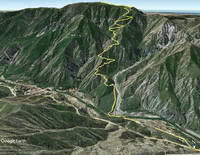
The two highest peaks in the front range of the San Gabriels, Strawberry Peak (6164′) and San Gabriel Peak (6161′) are about three miles apart as the raven flies and about 6 miles apart by trail. If you don’t mind running/hiking a third of a mile on Mt. Wilson Road, you can do both of them from Red Box as a 12 mile run/hike with a total gain of about 3000′.

Strawberry Peak and Mt. Lawlor from San Gabriel Peak.

Earlier this morning, I’d done San Gabriel Peak. It’s the shorter of the two ascents — from Red Box it’s about 2.4 miles to the summit. While the elevation gain is nearly the same as climbing Strawberry, it is a less strenuous and more straightforward peak. Except for a short stint on the service road below Mt. Disappointment, the grade of the San Gabriel Peak Trail is relatively constant — and the trail goes all the way to the summit.

Josephine Peak (5558') and Mt. Lukens (5074') from the summit of Strawberry Peak.
Josephine Peak and Mt. Lukens from the summit of Strawberry Peak.

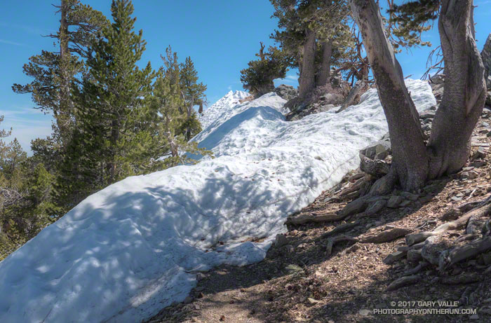
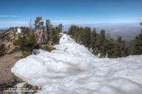
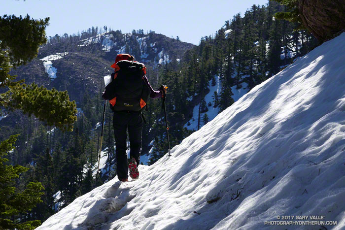
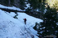
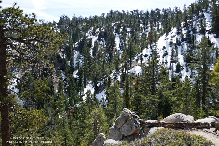
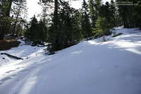
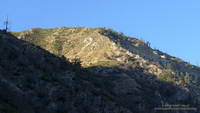
The route up Strawberry Peak is distinctly different. The initial 2.5 miles follows the Strawberry Peak Trail to Lawlor Saddle, gaining a moderate 500′ along the way. From there a steep, rough and sometimes rocky use trail ascends 950′ in a little over a mile to Strawberry’s summit.

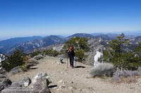
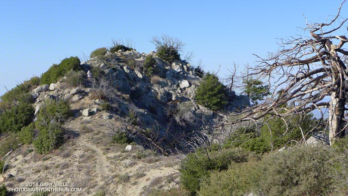
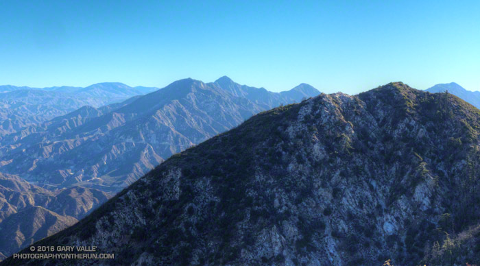
That’s where I was now — nearly at the end of that brutal mile-long climb. My heart was racing and my legs felt like Jello. Reaching the crest of Strawberry’s final false summit, I jogged across the shoulder of the peak and on uncooperative legs climbed the final few feet to the summit.

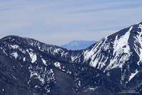
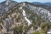
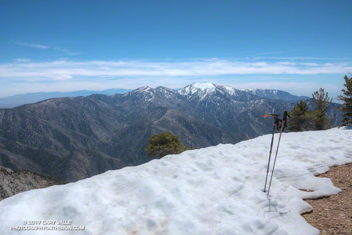
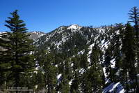
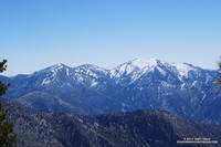
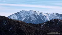
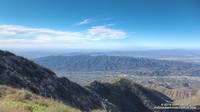
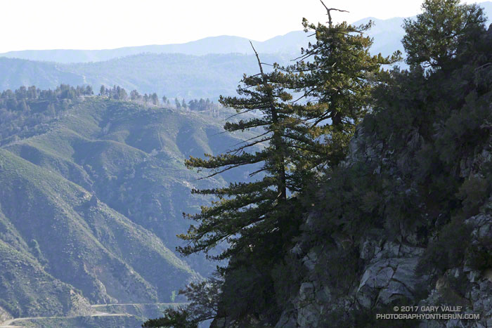
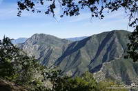
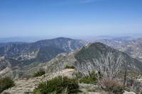
To the southeast, San Gabriel Peak and Mt. Disappointment stood across the canyon and further to the east, indistinct in the morning haze was snow-capped Mt. Baldy. To the west, the view extended past Josephine Peak and Mt. Lukins to the San Fernando Valley, Santa Monica Mountains and Santa Susana Mountains.

The southwest side of San Gabriel Peak was burned in the 2009 Station Fire.

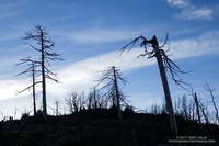
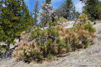
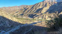
Recovery from the devastating 2009 Station Fire continues on both peaks. The amount, extent and size of Poodle-dog bush (Eriodictyon parryi) in the burn area is slowly diminishing. Some plants have died, but there are still viable plants of which to be wary. These plants were on the San Gabriel Peak Trail, above the notch, on the final climb to the summit of the peak. I don’t recall seeing any Poodle-dog bush on the ascent of Strawberry from Red Box, but it is still present on the west side of the peak.

Some related posts: Strawberry Peak, Switzer’s and the Old Colby Trail, Bear Canyon Loop Plus Strawberry Peak, After the Station Fire: Ten Miles – Four Peaks

Savoring the Snow Between Islip Saddle and Mt. Baden-Powell

Snow on the PCT east of Mt. Burnham.

The two hikers stopped on one side of the broad chute and I stopped on the other. We were on the Pacific Crest Trail about a half-mile from Little Jimmy Campground and had paused to put on micro spikes before crossing the icy slope. It was the same chute that had been so unnerving for a couple hiking down from Little Jimmy on a chilly morning two weeks before.

https://photographyontherun.com/content/binary/SanJacintoDawsonBaldy1020343c.jpg
Mt. San Jacinto from Mt. Baden-Powell. Click for a larger image.

After the hikers crossed we chatted for a moment about the snow. They were doing the PCT and I asked them what gear they used on Fuller Ridge — an infamous section of the trail on Mt. San Jacinto. They said they’d used micro spikes and ice axes. The segment had gone well, but at one point it had taken them four hours to do two miles!

It’s not often there’s this much snow in April in the mountains of Southern California. After venturing to Mt. Hawkins a couple of weeks ago, I had wanted to get back to the San Gabriels and check out the snow on the higher part of the crest between Mt. Burnham (8997′) and Mt. Baden-Powell (9399′).

Mt. Burnham (near) and Throop Peak (behind) from just west of Mt. Baden-Powell.

The photo on the left is a view west along the crest from the shoulder of Mt. Baden-Powell to Mt. Burnham and Throop Peak. Strong, southerly winds that accompany Winter storms blow from left to right across the crest, depositing extra snow in the wind-shadowed lee of the ridge. Snow accumulates along the ridge in dense, deep drifts, which in a big snow year can persist well into Summer.

Snow at 9100 feet along the crest just west of Mt. Baden-Powell
Snow at 9100′ along the crest just west of Mt. Baden-Powell.

The PCT between Mt. Baden-Powell and Throop Peak generally follows along the crest, tending to the north (right) side of the ridge and detouring around Mt. Baden-Powell and Mt. Burnham on their north slopes, and around Throop Peak on its southeast side.

Today, I stayed more or less on the crest between the summit of Baden-Powell and the PCT’s junction with the Dawson Saddle Trail, using the trail and snow where possible, but avoiding big drifts and steeper snow slopes. Between Throop Peak and Islip Saddle I stayed on the trail, and used micro spikes in a couple of places.

Lower elevation snow is melting relatively rapidly, but snow on the north-facing slopes at higher elevation could be around for weeks. Some patches and drifts may last into June or July. We’ll see!

Snow-capped Pine Mountain, Dawson Peak and Mt. Baldy from the summit of Mt. Baden-Powe;;

On the summit of Baden-Powell I pondered Mt. Baldy and thought about Sam and his love of the outdoors and Mt. Baldy. His effusive spirit will linger there always, and we’ll smile when we encounter it.

Warming Up for the PCT

Snow on the Pacific Crest Trail near Little Jimmy Spring. April 2, 2017.

Seasonal snowfall in the mountains of Southern California is inconsistent at best. According to Tony Crocker’s Your Guide to Snowfall, in the past 20 years SoCal snowfall has ranged from a record high of 267 inches during the strong El Nino of 1997-98, to a low of 29 inches in 2013-14 during our prolonged drought.

Snow-covered slopes from the Pacific Crest Trail near Little Jimmy Spring. April 2, 2017.
Snow-covered slopes from the PCT near Little Jimmy Spring.

So far this season, Your Guide to Snowfall’s total for SoCal is 143 inches, which is a bit above average and far more than we’ve had in recent years. After seeing the amount of snow on the higher peaks of the San Gabriels from Mt. Waterman a couple weeks ago, I was curious to see what the conditions were on the PCT between Islip Saddle (6650′) and Mt. Baden-Powell (9399′).

Joining me on today’s adventure was Patty Duffy. An avid outdoorsperson and ultrarunner, Patty did the JMT last year, and will soon be embarking on an epic border-to-border journey on the Pacific Crest Trail. Epitomizing the “hope is not a strategy” approach to challenges, today she was using much of the gear she would be using on the PCT — and in addition — carrying a sleeping bag, tent, stove and two days food!

Icy stretch of snow on the PCT at 7100', about 0.7 mile from Islip Saddle.
Icy stretch of snow on the PCT at 7100′, about 0.7 mile from Islip Saddle.

Even though we started an hour later than normal, and temperatures had warmed  the past couple of days, the snow on the shaded, north-facing slopes was still icy. Two hikers on their way down from Little Jimmy had trouble crossing one slippery slope. They had no crampons or micro-spikes and threw dirt on the snow to get by. It was obvious when we reached the area they described – a northeast facing gully. The slope was steep enough that a fall would have been very serious. Steep slopes, chutes and gullies are common along the trail between Islip Saddle and Baden-Powell.

Pine Mountain, Dawson Peak and Mt. Baldy from near Mt. Hawkins.

The question of what is appropriate gear for hiking an icy trail in this kind of terrain doesn’t have a simple answer. Boots, “real” crampons, and an ice axe provide a lot of security when crossing a steep, icy slope; but many other combinations of footwear, traction devices, poles, and self-arrest tools are commonly used. Conditions can rapidly improve or deteriorate and equipment can fail. Whatever combination of equipment is selected it’s important to understand its use and limitations.

After reaching an elevation of about 8000′, we stayed on the crest all the way to Mt. Hawkins (8850′) and the Mt. Hawkins lightning tree. The ridge route had the advantage of being mostly snow-free, but in places is quite rocky and steep. There are also a number of downed trees scattered across the ridge — vestiges of the 2002 Curve Fire.

Summit of Mt. Hawkins (8850').
Patty on the summit of Mt. Hawkins (8850′).

In middle of Winter in 2014 there was so little snow on the PCT between Islip Saddle and Mt. Baden-Powell it was possible to run to Baden-Powell and back, do Mt. Hawkins, Throop Peak and Mt. Burnham along the way, and be back to Islip Saddle in the early afternoon. Not today. Winter’s storms had left more of the trail snow-covered than snow-free — and not with just a little snow.

A little beyond the Hawkins – Throop Peak saddle we stopped at a sunny, wind-protected spot with a nice view of Mt. Baldy for a few minutes, and then headed down. The snow conditions had improved considerably, and at one point we glissaded down a short slope.

It had been another outstanding day in the mountains, and I could only sigh, thinking of the many great days and experiences that Patty would have on the Pacific Crest Trail.

Downed Trees, Melting Snow and a Waterfall

Snow-covered slopes from the Mt. Waterman Trail

Climbing up the slope and around the big incense cedar I stopped for a moment to enjoy the smell of the splintered wood. There had been so many trees across the trail I’d lost count. This was in the neighborhood of the 35th tree I’d had to work around on my way to Mt. Waterman.

Trees near Three Points burned in the 2009 Station Fire
Trees burned in the 2009 Station Fire

My run on the Mt. Waterman & Twin Peaks Trail had started at Three Points. Initially, I’d been encouraged to see some trees had been cut and removed from the trail. But the area was hard hit by the 2009 Station Fire and the combination of fire, years of drought, and rough winter weather seemed to be felling an increasing number of trees each year.

Across the canyon the north face of Twin Peaks was still blanketed in snow. On this warm, south-facing slope the snow was almost gone, exposing a veneer of pine needles, last Summer’s gray and wilted ferns, and the Winter excavations of industrious moles. In every gulch and gully water spilled down the mountainside; splashing, bubbling and burbling downslope under gravity’s spell.

Snow-covered Mt. Baldy from the Mt. Waterman Trail
Mt. Baldy from the Mt. Waterman Trail

This was supposed to be a recovery run, following last Saturday’s abridged — but arduous — run on the Backbone Trail. (Many thanks to Howard & Mike and all the volunteers!) The plan was to just go to the summit of Waterman and then back down the same way. But… the idea of crawling over, through or around more than 40 trees a second time just didn’t sound that appealing.

When I reached the junction with Mt. Waterman’s summit trail it took about a millisecond to make the decision to continue on the loop. It would be longer, and would have more elevation gain, but it was a beautiful day and my legs felt OK. Who knew when there would be another opportunity to do the loop in these conditions?

Snow along the Mt. Waterman Trail about a half-mile from Buckhorn
Snow along the Mt. Waterman Trail

Much of the trail down to Buckhorn was covered with snow. Not so much snow as to be a problem, but enough to be interesting and scenic. The weather was great and snow conditions excellent. Following the tracks of hikers, my socks didn’t even get wet!

Reaching Angeles Crest Highway, I ran east a short distance to the entrance of Buckhorn Campground. The gate was locked and the campground still closed for the Winter. Patches of snow, deadfall and other debris littered the area. When the camp is open, I top off my water here. Today the faucets were dry, but with the cool weather that would not be an issue.

Most of the hikers on the Burkhart Trail were going to see Cooper Canyon Falls. Seeing the falls was one of the reasons I’d decided to continue on the loop. My thoughts drifted back to April 1995 when Gary Gunder and I carried our kayaks down this trail and paddled Little Rock Creek from Cooper Canyon to the South Fork. (We put-in below the falls.)

The flow over the falls was the most I’d seen in several years and was probably nearing its peak. After enjoying the falls for a few minutes I scrambled out of the gorge and headed up the PCT. Like all that visit the falls, I now had to climb out of Cooper Canyon.

Drought-stressed young pine in Cooper Canyon

The effects of a prolonged drought don’t just disappear overnight, no matter how much it rains or snows. This was particularly evident on the sun-baked segment of the PCT above Cooper Canyon Camp. Just above the camp a large, green-needled Jeffry Pine had collapsed, leaving a large crater where its roots had been. In the year since I’d been on the trail, trees on the warmest, south-facing slopes had become more drought-stressed. It seemed additional trees had died and more had yellowing and brown needles.

Cooper Canyon can be hot, but today the temperature was pleasant. Eventually I reached Cloudburst Summit and clambered over a final steep patch of snow to reach the saddle. Three Points was now just a few miles away. I crossed Hwy 2 and started running down the trail.

After the Station Fire: Strawberry Peak Summit Regrowth

Chaparral regrowth near the summit of Strawberry Peak

Did the Colby Canyon – Strawberry Peak – Red Box loop again over the Thanksgiving holidays. While taking some photos near Strawberry’s summit I was struck by the regrowth that has occurred since the 2009 Station Fire. What caught my eye were the bare limbs of the old growth, burned in the fire, projecting from the new, dense, green growth.

The growth of the chaparral over the seven years since the fire does not appear to have been noticeably impaired by the 2011-2015 drought in Southern California. (In the photograph above note the height of the regrowth compared to my friend near the summit.)

This conclusion is based in part on the observation of chaparral regrowth following other fires, such as the 2005 Topanga Fire, but is also supported by comparing the amount of new growth to the pre-Station Fire growth. This can be inferred by the length of the burned limbs and the approximate age of the chaparral when burned by the Station Fire.

According to the FRAP California geodatabase of fire perimeters, the last fire to burn the summit of Strawberry Peak was the 1979 Sage Fire, which burned approximately 30,000 acres. Before that you have to go back to 1896 to find another fire in the database that burned Strawberry’s summit.

In the absence of fire, it appears that in another 23 years the chaparral in the title photo could reach a similar height and extent to the old growth.

Mt. Lukens, Then and Now

View of the San Gabriels from the Stone Canyon Trail
View of Josephine, Strawberry and other peaks from the Stone Canyon Trail

Note: This ascent of the Stone Canyon Trail was in the Fall, following five years of drought. On a Spring 2020 ascent, following a relatively wet period, there was a moderate amount of poison oak and some sections of the upper half of the trail were badly overgrown.  In Spring 2021, a lot of work had been done on the trail and it was in excellent condition.

The last time I climbed Mt. Lukens was in the 70s. Drawn by its classic line, Phil Warrender and I climbed Lukens’ west ridge — a long, trailless ascent that started near the probation camp on Big Tujunga Canyon Road. Many years and many adventures later I was back on Lukens — this time on the Stone Canyon Trail.

Curious about the current condition of the trail, last night I read a few recent trip reports. It was a bit like reading tabloid news. If the reports were to be taken at face value, it would be a hellish, impossible to find, unmaintained, horribly overgrown, washed out trail that was lined with poison oak and poodle dog bush, and writhing with rattlesnakes.

Google Earth image of Mt. Lukens and the Stone Canyon Trail
Mt. Lukens and the Stone Canyon Trail

It was evident in the first mile that the Stone Canyon Trail is a classic, no nonsense, ear-popping trail. First shown on the 1933 La Crescenta Quadrangle Advance Sheet, the route of the trail is pretty much the same now as it was then, starting near Wildwood in Big Tujunga Canyon and zig-zagging up the ridge just east of Stone Canyon to the summit of the peak.(The 1933 topo also shows a trail along the route Phil and I climbed.)

The Stone Canyon Trail tops out about a half-mile northwest of Mt. Lukins’ summit. Like many urban peaks, the summit is cluttered with electronics, but there are still worthwhile views on and near the top of the peak.

View from Mt. Lukens of the Crescenta Valley, the Verdugo Mountains and beyond.
Crescenta Valley, the Verdugo Mountains and beyond.

While on the summit, a LASD’s Air Rescue 5 helicopter flew by to the east — I guessed on the way to the Barley Flats staging area. But part way down the peak I heard the airship to the northeast and noticed a cloud of dust being stirred up from a turnout on Angeles Forest Highway. Once again Air Rescue 5 was at work. It’s astonishing how many calls they get.

Continuing to run down the trail I thought about some of the online comments I’d read the night before.

Hellish? Well, sure, on a hot day. Unless you’re looking to get in some heat training, don’t climb it on a hot day. Climb it when the weather is clear and cool!

Bottom of the Stone Canyon Trail

Impossible to find the trail? Except for the big sign at the trailhead parking lot, I didn’t see any trail markers. But if you have a “big picture” view of where the trail is in relation to the parking lot, it’s not too hard to find.

Unmaintained? These days most trail maintenance is done by volunteers. A trail like the Stone Canyon Trail is kept alive through use, sporadic organized trailwork, and an occasional snip here and snip there.

Horribly overgrown? The higher you go the more overgrown it is, but today it was not yet to the point that serious bushwhacking was required. I wore running shorts. (But I almost always wear running shorts.)

Washed out? Yes, there were a few small washouts, and the margin of the trail has collapsed in a number of places. With care, all were passable. One of the washouts was a little larger, and required a bit more care than the others.

Slopes at the head of Stone Canyon on Mt. Lukens.
Slopes at the head of Stone Canyon

Poison oak and poodle dog bush? Maybe I missed it, but I didn’t see any poison oak. There was a minuscule amount of dried up PDB. (Ask me about the PO later in the week.)

Rattlesnakes? Always a possibility, even in Winter. But this is true in most areas of Southern California. In my experience the chance of encountering a rattlesnake is less from November through February, but there’s still a chance.

Ear-popping? The trail gains about 3,270 feet in 3.8 miles. My ears “popped” a couple of times on the way up.

Theoretically the gate on Doske Road is open from 8:00 a.m. to 8:00 p.m. The Angeles National Forest web site showed the status of the Wildwood Picnic Site to be open, but the gate was not open today. I parked in the large turnout on Big Tujunga Canyon just west of the gate and ran about a half-mile on Doske and Stonyvale Roads to the parking lot and trailhead.