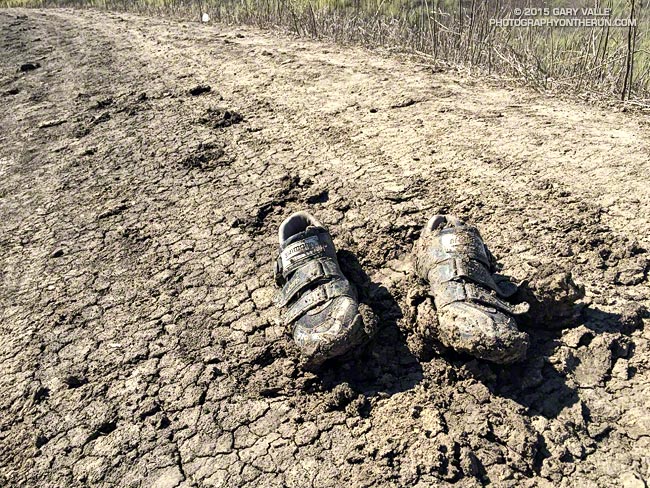
Exactly as I found them — abandoned on the road — on my run at Ahmanson today.
Some related posts: It Was So Muddy That…, A Two Mud Run Summer and Wet Winter Outlook for Southern California

Exactly as I found them — abandoned on the road — on my run at Ahmanson today.
Some related posts: It Was So Muddy That…, A Two Mud Run Summer and Wet Winter Outlook for Southern California
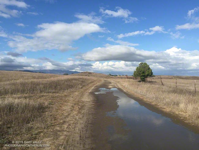
Ahmanson Ranch gets notoriously muddy when it rains, but it is exceptionally rare for it to rain enough in the Summer to do a run in the mud. Due in part to a warm Pacific, El Nino and a little boost from the Madden-Julian Oscillation in early July, it’s been a record two mud run Summer at Ahmanson Ranch!
The first mud run day was on July 18, when the Cheeseboro RAWS recorded 1.32 inches of rain. That day I ran in the San Gabriels, where the main issue was thunderstorms.
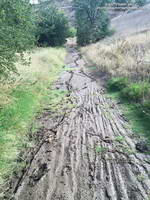
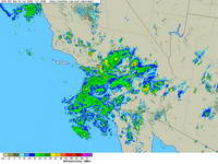
Tuesday (September 15) was a different story. It rained hard overnight — more than three-quarters of an inch — and in the afternoon I did one of my standard weekday loops from the Victory Blvd. trailhead — out East Las Virgenes Canyon, through Las Virgenes Canyon, and up the Beast to Lasky Mesa. It felt more like November than September. After running through a particularly muddy section in Las Virgenes Canyon, heavy plates of mud had built-up on my shoes. Normally I would curse, but on this run I just laughed. It was great to be out in the wet and muck.
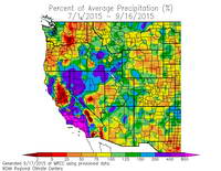
Both days set rainfall records at Downtown Los Angeles (USC). July 18 was the wettest day in July and July 2015 the wettest July since recordkeeping began in 1877. September 15 set a new rainfall record for the date and was the second wettest day in September on record. To date, September 2015 is the third wettest September on record. The rain year (July 1 to June 30) is off to a great start in Southern California and the 2015 El Nino has continued to strengthen.
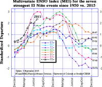
Based on the July-August Multivariate ENSO Index (MEI), for the time of year the 2015 El Nino is one of the three strongest El Ninos since 1950. A survey of dynamical and statistical ENSO models by the IRI & CPC suggests continued warming in the central equatorial Pacific with a peak of the temperature anomaly in the Nino 3.4 region in the OND or NDJ season.
The 2015 El Nino is being compared to the “Super” El Ninos of 1997-98, 1982-83 and 1972-73. It’s too early to tell how the 2015 event will stack up against 1997-98 and 1982-83, but it already has exceeded the strength of the 1972-73 event. How might a Super El Nino affect Southern California rainfall? Historically, they have produced some of the wettest rain years on record. Downtown Los Angeles (USC) recorded 31.01 inches of rain in 1997-98 and 31.25 inches in 1982-83.
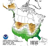
The climate context is different than it was decades ago, but very strong El Ninos are different beasts and rev up the atmosphere in a way that dominates global weather. Assuming the 2015 El Nino maintains (or increases) its strength into November or December, it should produce above average precipitation in Southern California this rain season, and perhaps result in an above average rain year for the southern half of the state. This is reflected in the Climate Prediction Center’s latest round of 3-Month Seasonal Precipitation Outlooks, including the Winter outlook for December, January & February 2015-16. We’ll see!
Related post: July Deluge a Preview of Southern California’s Upcoming Rain Season?
It wasn’t so much a surprise that there was thunder or that it was starting to shower again. It was that I was hearing thunder all around me — to the east toward Mt. Waterman and Twin Peaks, to the south toward Mt. Wilson and the San Gabriel Valley, and to the west toward Big Tujunga Canyon and the San Fernando Valley. This was clearly more than an isolated summer build-up. Pockets of showers, some light and some heavy, could be seen in the distance and I wondered just how wet I was going to get.
The answer was “pretty wet!” That was on a run in the San Gabriel Mountains on Saturday, and was the result of the first wave of moisture and instability associated with tropical system Dolores and a strong monsoonal flow from Baja. An even stronger surge of moisture followed Sunday afternoon with rain rates exceeding an inch an hour. From 5:15 p.m. to 5:25 p.m. a CBS Radio weather station on Mt. Wilson recorded a half-inch of rain in just 10 minutes!
Though the heavy rain created its own problems — including flash floods, debris flows and rock slides — the soaking rains helped quell the Pines Fire near Wrightwood and the North Fire near Cajon Pass. Over the three day period from Saturday to Monday the Big Pines Remote Automated Weather Station (RAWS), near the Pines Fire, recorded 3.12 inches of rain. Several stations in the San Gabriels recorded more than three inches of rain, including Clear Creek and Opids Camp.
Many locations set new records, not only for the date, but for any day in July. Downtown Los Angeles (USC) set rainfall records for the date on Saturday, Sunday and Monday. Downtown Los Angeles recorded 0.36 inch of rain Saturday. This is more rain than any day in any July since recordkeeping began in 1877. That one day of rainfall even broke the monthly record for July in Los Angeles! Prior to this event the wettest July on record was in 1886, when 0.24 inch was recorded.
Strengthening El Nino conditions and the active phase of the Madden-Julian Oscillation contributed to the development of Dolores in the Eastern Pacific, enhancing convection. Anomalously warm SSTs in the tropical and sub-tropical Eastern Pacific also played a role, helping to maintain the strength of Dolores and increasing the amount of water vapor entrained by the system.
This year’s El Nino is very different than last year’s on again, off again event. This year’s El Nino is already established, well-coupled with the atmosphere and growing in strength. It’s firing on all cylinders and at this point it appears the only question is, “How strong will it get?”
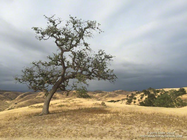
Following four rainfall years in which Downtown Los Angeles (USC) has cumulatively recorded less than half of normal rainfall and accrued a precipitation deficit of more than 30 inches, many of the valley oaks at Ahmanson Ranch (Upper Las Virgenes Open Space Preserve) are drought stressed.
The most obvious signs of drought stress in valley oaks and many other plants are a reduced number of leaves and reduced leaf size. In severely stressed valley oaks the foliage has the appearance of a tree that is recovering from a wildfire.
At Ahmanson the degree of stress varies widely from tree to tree. The “TV tree,” an aesthetically-shaped and often-photographed valley oak on the west side of Lasky Mesa appears to be showing a higher than average level of stress.
Valley oaks and live oaks cohabit the oak savannas at Ahmanson Ranch, but live oaks appear to be more drought tolerant. The lone Blue Oak at Ahmanson seems to be doing OK and has at least as much foliage as it did last year at the same time.
Update January 15, 2021. “The Tree” died in the Spring of 2020, when Ahmanson was closed due to COVID-19. Although scorched in the Woolsey Fire, it never recovered from the 2011-2015 drought, and that appears to have been the primary cause of death.
Some related posts: Ahmanson Blue Oak, The Color of Rain IV
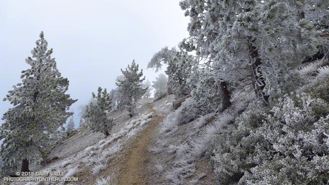
Even with a wind shell and multiple layers the gusts of wind were sharp-edged and penetrating. The weather was spectacular, but it was very windy and very cold.
My run on the PCT had started at Islip Saddle in the San Gabriel Mountains. At 8:00 am the temperature at 6593′ had been about 35 degrees. The north wind funneling through the saddle had roared through the pines, buffeting their stout limbs and telling me to put on every scrap of warm clothing I had in my pack.
The broad canyon of the South Fork seemed to act as a wind tunnel — drawing the wind from the high desert into and over the crest. Even with a gloved hand it took only a couple of minutes before my camera became too cold to hold.
I was on my way to Mt. Baden-Powell and nearly up to Mt. Hawkins. With every stride up the mountain the temperature had dropped. Father Frost had frozen the landscape and me along with it.
Had it really been just a week ago when I had broiled in 90+ degree temps on the south-facing sections of trail on the Leona Divide 50M course?
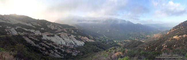
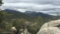
Well, maybe not Shangri-La, but a Lost World kind of morning on the Calabasas Peak fire road segment of the Secret Trail.
Calabasas Peak fire road traverses the rock formations on the left, descending to Stunt Road. At Stunt the route continues up the Stunt High Trail to the Backbone Trail. Here you can do an optional out and back to Saddle Peak, shrouded in clouds in this photo, or turn west on the Backbone Trail and continue mostly downhill to Piuma Road near Malibu Canyon Road. Malibu Canyon is in the distance on the right in the photo.
The panorama is from a run earlier this month. Here’s a larger version.
Related post: Secret Trail Variations