Category Archives: weather|southern california

A Little Rain in Los Angeles

Droplets of rain on the funnel shaped web of the western grass spider, Agelenopsis aperta.

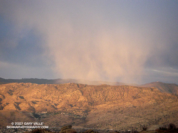
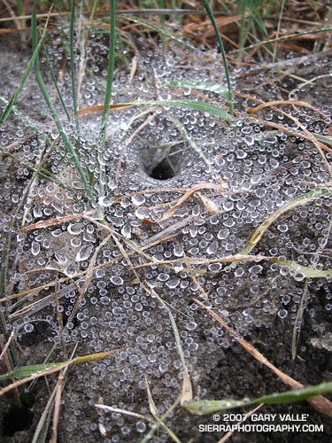
We received a little rain in the Los Angeles area earlier this week. There was just enough light rain to dampen my shirt, muddy my running shoes, and ornament this web with droplets of water. Refreshing as it was, the precipitation did little to relieve our ongoing drought.

To date, according to NWS data,  this is the driest water year in Los Angeles since recordkeeping began in 1877. From July 1, 2006 to March 22, 2007 Downtown Los Angeles (USC) has recorded only 2.47 inches of rain. This is 10.79 inches below normal. Checking back through NWS records, 2.47 inches is the total amount of rain recorded in Downtown Los Angeles from May 23, 2006 through today — a period of 10 months!

In the past few years Los Angeles has experienced a number of weather extremes. The driest water year on record for Los Angeles was just set in 2001-2002, when 4.42 inches were recorded. Then in 2004-2005, Los Angeles was deluged with 37.25 inches of rain — the second wettest on record. During that period, Opids Camp in the San Gabriel Mountains recorded over 100 inches of precipitation! In July of last year Pierce College in Woodland Hills recorded a new all time high temperature for that station of 119°F. This may have been the highest temperature ever recorded in Los Angeles County. In mid January of this year many new record low temperatures for the date were set in the Southern California area. Pierce College plunged to a record low of 20°F (-6.7°C) and a temperature of 10.4°F (-12°C) was recorded at a research site in the Santa Monica Mountains. 

Computer models are indicating another chance of rain early next week. At the moment, the system looks like it could produce rainfall amounts similar to Tuesday’s system, perhaps a little more. But with the equatorial Pacific and atmosphere looking more and more La Nina like, significant rain is looking less likely, and we may be talking about record drought in Southern California for many months to come.  We’ll see!

The photo of the wet spider web was taken near Lasky Mesa in Upper Las Virgenes Canyon Open Space Preserve (formerly Ahmanson Ranch) on Tuesday, March 20, 2007. The funnel shaped web is probably that of the western grass spider, Agelenopsis aperta.

Related posts: Chaparral Freeze, The Color of Rain, El Nino Drought, Sunset Snow Shower, Rainy Morning on Rocky Peak Road.

Cheeseboro Bound

Two runners climb up the last yards of a hill before descending into Las Virgenes Canyon in Upper Las Virgenes Canyon Open Space Preserve.

Two runners climb up the last yards of a hill before descending into Las Virgenes Canyon in Upper Las Virgenes Canyon Open Space Preserve.

The trail is a connector that joins East Las Virgenes Canyon with upper Las Virgenes Canyon. Our 15 mile loop started at the Victory trailhead, following the El Scorpion Trail to another long-used trail that climbs up to the ridge along the northern boundary of the preserve. From here we descended to Las Virgenes Canyon and worked over to Shepherd’s Flat and down Cheeseboro Canyon, eventually returning to the Victory trailhead by way of the main drag.

The area seen in the photograph is a small portion of the 24,000 acres that was burned in the Topanga Fire in late September 2005.

Although an undercoat of green is apparent, the drought in Southern California continues. According to NWS climate data, as of today, Downtown Los Angeles (USC) has recorded only 2.42 inches of rain since the water year began on July 1, 2006. This total is nearly 9 inches less than normal.

Chaparral Freeze

Freeze damaged Laurel Sumac in Malibu Creek State Park.

Updated March 6, 2007

As evidenced by their survival, native plants are generally well adapted to the environment in which they live. Fire, flood, drought, heat or cold, they’ve seen it all – or nearly so.

On January 14, 2007 many new record low temperatures for the date were set in the Southern California area. Several locations in the San Fernando Valley recorded temperatures in the 20’s. Pierce College in Woodland Hills plunged to a record low of 20°F (-6.7°C).

The freezing temperatures resulted in extensive damage to fruit crops, nursery stock, and landscaping. The brown leaves of freeze damaged shrubs, trees and other plants are a common sight in the Los Angeles suburbs.

Since the freeze, I’ve run in several areas of the Santa Monica Mountains, Santa Susana Mountains and Simi Hills, and most native chaparral shrubs appeared to have weathered the cold temperatures well, exhibiting very minor, if any, visible damage. However, there are some exceptions.

One obvious exception is laurel sumac (Malosma laurina). I first noticed instances of laurel sumac with damaged leaves and stems on a run at Sage Ranch on January 24. Initially, I thought the damage might be limited to sprouting laurel sumac in the 2005 Topanga Fire burn area, but on subsequent runs damaged plants were seen in several areas unaffected by the fire, including Topanga and Malibu Creek State Parks. Now that the dead leaves and stems have turned brown, the affected plants stand out in the chaparral, and the extent of the damage is easy to see.

The sensitivity of Laurel Sumac and other chaparral plants to freezing temperatures and drought has been studied extensively by Dr. Stephen Davis of Pepperdine University’s Seaver College Biology Department. This research confirms that the leaves and stems of laurel sumac are not as tolerent of freezing temperatures as some other chaparral shrubs. This reduced tolerance probably affects the distribution of the plant, favoring its growth in warmer coastal locations and inland microclimates.

Dr. Davis reports that, in addition to laurel sumac, other species that have been damaged at the lower, colder distributions in the Santa Monica Mountains include green bark ceanothus (Ceanothus spinosis), big pod ceanothus (Ceanothus megacarpus), sugar bush (Rhus ovata), and some hairy-leaf ceanothus (Ceanothus oliganthus). The lowest temperature recorded at his field sites was 10.4°F (-12°C).

A factor in the damage is that the freeze occurred during a period of relative drought. As of January 14, Downtown Los Angeles (USC) had recorded only 1.31 inches of rain since (but not including) May 22, 2006 – a period of nearly 8 months.

Although some of laurel sumac’s adaptations to fire and drought may adversely affect the resistance of its foliage to freezing temperatures, it is precisely these adaptations that will enable most of the freeze damaged laurel sumacs to resprout and survive.

The photograph of freeze damaged Laurel Sumac was taken on the Backbone, Bulldog & Beyond run.

A La Nina During an El Nino?

Grass along the margins of the main drag in Upper Las Virgenes Canyon Open Space Preserve,formerly Ahmanson Ranch.

Sporadic rain in the Los Angeles area has finally produced a little green in local open space areas. Here, along the margins of the “main drag” in Upper Las Virgenes Canyon Open Space Preserve (formerly Ahmanson Ranch).

As of today, (preliminary) NWS climate data indicates Downtown Los Angeles (USC) has recorded 1.92 inches of rain since July 1. This is 7.31 inches below normal. Leafing back through weather service data prior to July 1, this is the total rainfall recorded since May 22, 2006 – a period of nearly nine months.

What happened to our El Nino rains? According to NWS scientist Ed Berry, “the global circulation has been generally La-Nina like since about late November.” This is despite an El Nino event that peaked in November or December, and persisted at moderate strength into January. See his blog Atmospheric Insights for the technical details.

A period of unsettled – possibly showery – weather is forecast for the Los Angeles area beginning Sunday evening and continuing pretty much through the week. At the moment* the best chance for measurable rain appears to be on Monday and Thursday. We’ll see!

*Updated Saturday, February 17, at about 11:00 a.m.

Related posts: The Color of Rain, El Nino Drought, Sunset Snow Shower, Rainy Morning on Rocky Peak Road.

Rainy Morning on Rocky Peak Road

Steam rises from Rocky Peak Road near Fossil Point.

It was nice to start a run in the rain and see a few mud puddles along the way! Southern California has had so little rain the last several months that any rain is something to celebrate. Since the start of the water year on July 1, the official weather station for Los Angeles at USC has recorded only 1.48 inches of rain. This is more than 5 inches below normal for the date, and depending on the rain received the next three days, the July 1 to January 31 rainfall total could be the 5th driest since recordkeeping began in 1877. (Downtown Los Angeles recorded only 0.02 inch over the three days, and according to a NWS statement issued February 1, July 1 to January 31 was the 5th driest on record.)

Unless you are particularly fond of mud, Rocky Peak Road is usually a good choice for a run if it’s raining, or has rained recently. Perched on a ridge on the border between Los Angeles and Ventura counties in Rocky Peak Park, its sandy soils are generally well drained. Except for a few short sections of road, mud isn’t too much of an issue unless you run beyond “fossil point,” the high point of the road at about mile 4.8. Here there is an outcrop of fossil scallop shells.

Related posts: San Fernando Valley from Rocky Peak, Chumash-Las Llajas LoopSunset Snow Shower

Sunset Snow Shower

Low angle rays of the setting sun highlight a snow shower over the Rocky Peak

When I heard the news reports of snow in the Santa Monica Mountains along Kanan-Dume road near Malibu, I hoped to find a little snow or hail up at Sage Ranch Park on my afternoon run.

The isolated snow showers, hail and sleet were produced by convective cells that developed as a result of instability associated with a passing upper level low. Some of these cells also generated some lightning and thunder.

There was no snow on the ground at Sage Ranch, but the low angle rays of the setting sun did highlight a snow shower over the Rocky Peak Park area. In March of last year there was snow at Sage Ranch and Rocky Peak.

Related posts: Chumash Trail Snow, Oat Mountain Snow, San Fernando Valley from Rocky Peak.