La Nina and the 2010-2011 Southern California Precipitation Outlook

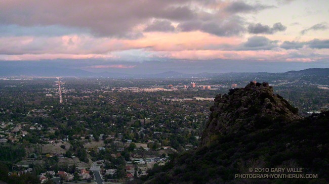
Clouds on Rocky Peak road

The second of two vigorous upper level lows to batter Southern California this Autumn has pushed the water year rainfall totals for many stations around the area to above normal.  Does that mean we’re likely to see the wet weather continue through the 2010-2011 rain season?


Probably not. Since last Winter, ENSO conditions in the equatorial Pacific have flip-flopped. The Multivariate ENSO Index (MEI) has plunged from the fifth strongest El Nino for Feb/Mar to the strongest La Nina for Aug/Sep. The Aug/Sep value of the MEI is the lowest since Jul/Aug of 1955. Generally, El Nino conditions result in wetter weather in Southern California, and La Nina drier.

A precipitation composite for eight years in which ENSO was transitioning from El Nino or Neutral conditions to La Nina indicates that “on average” the coastal Southern California climate division recorded about 4 to 5 inches less precipitation than normal for the period November through March. The percent of normal water year rainfall recorded at Downtown Los Angeles (USC) ranged from a low of 53% (1988, 8.08″), to a high of 99% (1973, 14.92″). The average rainfall for these years was 77%, or 11.7″.

Maps generated using the ESRL/PSD page Risk of Seasonal Climate Extremes in the U.S. Related to ENSO do not indicate a higher than normal risk for an extremely dry rain season in Southern California when La Nina conditions are present.


0

La Nina composites from CPC’s ENSO Temperature & Precipitation Composites page suggest the period Jan-Feb-Mar may be particularly dry, but this is not reflected in CPC’s official seasonal precipitation forecasts.

CPC’s Three-Month Precipitation Outlooks and NOAA Winter Outlook were updated yesterday. The precipitation outlook for Nov-Dec-Feb in the Coastal Southern California climate division shows equal chances of above average, near average, or below average precipitation. As the rain season progresses, these probabilities become only slightly skewed toward below normal precipitation. The skew becomes more pronounced in Feb-Mar-Apr when the probability of below normal precipitation increases to 45%.

The title photograph is from Sunday’s out and back run from Chatsworth Reservoir to Rocky Peak.

Angeles National Forest Extends Station Fire Closure to September 19, 2011

Update Friday, May 13, 2011. Good news! Effective Monday, May 16, 2011, Angeles National Forest is reopening about half of the area of the Forest currently closed as a result of the Station Fire. This reduces the closure area from 186,318 acres to 88,411 acres, and opens most of the burn area south and east of Angeles Crest Highway (Hwy 2) from Bear Canyon east to Twin Peaks. Some of the trails and areas opened are the Sunset Ridge Trail, Bear Canyon Trail, segments of the Gabrielino Trail, Nature’s Canteen Trail, San Gabriel Peak and Mt. Disappointment, Valley Forge Trail, Kenyon DeVore Trail, Silver Moccasin Trail, Pacific Crest Trail (some rerouting), Twin Peaks and the Mt. Waterman-Twin Peaks Trail from Three Points. For more information see the news release, detailed map, and other information related to Closure Order No. 01-11-03 on the Angeles National Forest web site.

On September 20th, after issuing a press release with the title, “Angeles National Forest reopens areas offering hiking, picnicking,”  Angeles National Forest (ANF) reopened about 5 percent of the Station Fire closure area, and extended the closure of the remaining 186,320 acres another year to September 19, 2011. Here’s an ANF map of the revised closure area (PDF).

According to the press release, most of the areas burned in the Station Fire remain closed “for public safety.” When will these areas reopen? In the press release former ANF forest supervisor Jody Noiron states, “The Forest Service intent is to reopen areas severely damaged in the fire over the next few years as conditions allow.”

It’s hard to understand the rationale for the extent and duration of this closure. Over the past year, many dedicated forest users have participated in permitted work parties and events in the closure area. We’ve  been on the trails and roads. We know firsthand that many miles of trails and dirt roads are passable, and much of the closure area could reasonably be in use.

Remarkably, a year after the fire, the size of the Station Fire closure area remains LARGER than the area burned by the fire! Some areas in the Forest that were burned are open, and some large areas that did not burn are closed.

Other than the boilerplate “to protect natural resources and provide for public safety” in the closure order, and some bureaucratic arm-waving, there has been very little information released documenting why these areas of ANF should remain closed.

According to an article posted on the Pasadena Star News web site (08/22/10 by Beige Luciano-Adams), acting ANF forest supervisor Marty Dumpis said, “It’s not just safety but also we have to allow the area to recover because if we allow people to start trampling over regrowth then they’ve just set it back another year. We hope people will be patient enough, allow natural recovery to begin, and then we can get some of these areas open.”

Is that the way Angeles National Forest higher-ups see us? The hikers, runners, and riders that most frequently use these trails are among the most experienced that visit the Forest. Trails constrain use, and are a minuscule part of the recovery area. If credible evidence exists that trail use would delay the area’s fire recovery, Angeles National Forest should make it available to the public.

To keep such a large area of public land closed for such an extended period following a Southern California fire is unprecedented. Even in the case of the largest Southern California fires, the Cedar and Zaca fires, closed areas in Cleveland and Los Padres National Forests were reopened within a year of the fire. In many cases fire closures in the National Forests of California have been lifted within days or weeks of a large fire. This reflects a general policy that closures be implemented and maintained as a last resort.

In a 2009 presentation following the Station Fire, Jody Noiren noted that Angeles National Forest:

– provides 72% of all open space in Los Angeles County
– has 17 million people living and working within 1 hour drive
– has 3.5 million visitors per year, of which half come from within a 50 mile radius of the Forest

It may simplify forest management, and be more convenient for the Forest Service to keep such a large area of Angeles National Forest closed, but it is clearly not in the public interest. Extending the Station Fire closure will not enhance recovery, increase protection of sensitive species, or prevent the spread of invasive plants. But it will deprive millions of people living and working nearby of an indispensable and intrinsic public resource.

Long experience in Southern California demonstrates that public lands can be reopened in a timely fashion following a fire without abusing resources, or putting the public in undue peril. It is time to stop the doublespeak and reopen all but the most severely damaged areas of the Station Fire burn area to public use.

The Station Fire closure area is in the congressional districts of Rep. David Dreier [R-CA26] and Rep. Howard McKeon [R-CA25]. California’s senators are Sen. Barbara Boxer [D-CA] and Sen. Dianne Feinstein [D-CA]. Determine and contact your Representative and Senators.

Morning Fog – Malibu Canyon

Fog in Malibu Canyon

Did a variation of the “Phantom” loop in Malibu Creek State Park this morning. The basic loop links together the Grassland, Liberty Canyon, Phantom, Cistern, Lookout, Yearling, Deer Leg, and Cage Creek Trails, as well as Crags Rd.

The peak in the haze on the left of the photograph in the distance is Saddle Peak. The peak on the right is Brent’s Mountain.

Subtropical Flow from an Upper Low

Hot on the heels of our record setting Autumn heatwave, an upper level low off the coast has been spinning subtropical moisture into Southern California. The unstable weather has produced some impressive clouds, isolated showers, strong thunderstorms, as well as a few rainbows. This thunderstorm development is north of Los Angeles.

From today’s run in the Simi Hills.

Photography and inspiration from running and other adventures in the Open Space and Wilderness areas of California, and beyond. No ads. All content, including photography, is Copyright © 2006-2024 Gary Valle. All Rights Reserved.