Cool Running in Southern California

Dave Burke cruising down a nice section of the PCT between Cloudburst Summit and Cooper Canyon.

Last year on this date, Southern California was in the middle of a heatwave. On June 20, 2008, Los Angeles Pierce College in Woodland Hills reached a record-setting high of 111°F, and on June 21 the temp reached 108°F!


Snow plant
Not so this June! So far this month, Downtown Los Angeles has not had a day when the average temperature was above normal. And it’s not only the low elevation stations that have been cool. Several times this month the overnight low at the Big Pines RAWS, near Wrightwood in the San Gabriel Mountains, has dropped into the thirties, and daytime temps have averaged more than 10 degrees below normal.


Three Points - Mt. Waterman Trail, west of the Twin Peaks Trail junction.
This translates to great running weather in Southern California, and near perfect weather for trail running in the San Gabriel Mountains. Today, did the Three Points – Buckhorn loop, along with a short detour up to the summit of Waterman Mountain. The route worked out to about 23 miles with a reality-checked elevation gain/loss of about 3800′. Here’s a Cesium browser View of a GPS trace of the run.

The title photo is of Dave Burke, cruising down a nice section of the PCT between Cloudburst Summit and Cooper Canyon.

Related post: Three Points Loop Plus Mt. Waterman

Chumash Astronomy: Reaching into the Upper World

Chumash astronomical petroglyph.

There is nothing quite so compelling as an unanswered question.

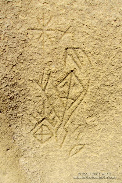
Several years ago, in the middle of a trail run, an unusually shaped rock formation caught my eye. After a little bushwhacking and exploration, I found a way to climb the formation, and on its summit found a small pictograph. I wondered if there might be other pictographs in the area, and on the way back to the trail found the inscription pictured above.

Later, I took a friend with more ethnographic experience to the top of the rock, and it was his opinion that the pictograph, as well as the nearby inscription, were not of modern origin. He also mentioned that the rock likely marked the point on the southeastern horizon where the sun rises on the Winter Solstice, as seen from a Chumash shrine several miles away.


Chumash pictograph
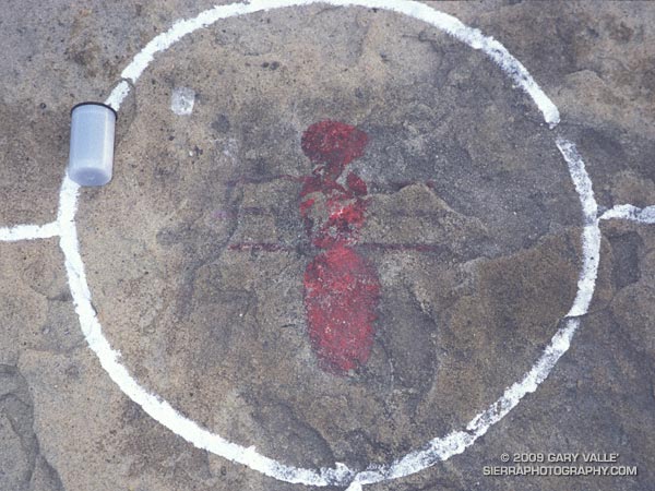
The pictograph on the solstice rock appears to have been painted using an ochre pigment, which may have been mixed in an adjacent cupule. It is in a harsh environment, fully exposed to the sun, wind and rain. It’s my guess that the white “alignment” reticule surrounding the pictograph is an unfortunate recent addition.

The petroglyph is in a concavity on the north side of a large boulder, and is better protected. That the drawing appears to be astronomical in nature, and is adjacent to a rock possibly used to mark the Winter solstice is probably not a coincidence.

To speculate on the purpose and meaning of such a drawing is to travel in time, and through the thoughts and eyes of another, visit a world far different than our own.

In this case that someone was probably an ‘alchuklash — an astronomer-priest-shaman who was a part of a religious-spiritual cult known as the ‘antap — a pervasive power elite within Chumash society.

The ‘alchuklash were adept astronomers, not only observing the Winter and Summer Solstices, but the moon, individual stars, asterisms, constellations, planets, Milky Way, eclipses and more. The observation and interpretation of the Upper World were an integral part of the Chumash cultural and world view.

But the Upper World did not exist on its own. The Chumash appreciated and celebrated the interdependency of Nature, and events in the Upper and Lower Worlds were inexorably tied to those in the Middle World of everyday existence. Using their specialized knowledge, the ‘antap facilitated communication and interaction between these worlds to the benefit, or peril, of the People.

It is in this context that in the drawing I see the powerful personage of an ‘alchuklash, who has reached into the Upper World. Perhaps the drawing is a commemoration of the power of the place. Perhaps it is a kind of owner’s manual, a premodern PDF, illustrating the purpose of the solstice rock. Or, perhaps it is something we cannot know.

Note: The contrast of the lines in the image has been increased to make them easier to see. In the ten years since I first photographed the etching, some detail has been lost in the lower right corner of the drawing. This image is from April 21, 2009.

Reference: Crystals in the Sky: An Intellectual Odyssey Involving Chumash Astronomy, Cosmology, and Rock Art. Travis Hudson and Ernest Underhay (Foreword by Anthony F. Aveni and illustrated by Campbell Grant). Socorro, New Mexico: Ballena Press Anthropological Papers No. 10, 1978, 163 pp.

PCT from Inspiration Point to Islip Saddle

View from near the summit of Mt. Baden-Powell.

Overnight the lows on the high peaks had dipped into the 30’s, and today the high temps would be 15-20 degrees below normal. If I could have ordered the perfect mix of temperature, clouds and sun for running in the Angeles high country, it would be difficult to top the weather this weekend and last.


Clouds and pines along south ridge of Mt. Baden-Powell in the San Gabriel Mountains.
Now that Hwy 2 was open between Islip Saddle and Vincent Gap, and we could do a car shuttle, Miklos, Krisztina and I had decided to run from Inspiration Point to Islip Saddle on the PCT. Starting at Inspiration Point instead of Vincent Gap adds about 4.5 miles to the run, but the miles are relatively easy, and the stretch is a good warmup for the 2800 ft. climb up Mt. Baden-Powell.

Here’s a Cesium browser View of a GPS trace of our approximately 18 mile route. We wandered down the south ridge of Mt. Baden-Powell, so this is a little longer than the usual route. The elevation gain was about 3300 ft., with an elevation loss of about 4000 ft. Continuing over Mt. Williamson to Eagle’s Roost would add about 4 miles and 1400 ft. of elevation gain.

Note: The speck in the summit photo is one of several violet-green swallows working lift and zooming along the top of southeast face.

Sage Ranch Recovery Run

California Buckwheat (Eriogonum fasciculatum var. foliolosum) at Sage Ranch Park.

Like many runners, I like to do a recovery run the day after a race, or strenuous run. Combined with some stretching before and after, an easy-paced run helps to work the bugs and stiffness out of the body and mind.

It may have been only 14 miles long on the map, but from my legs point of view, yesterday’s hike/run up and down Mt. Baldy’s South Ridge felt more like about twenty normally hilly miles.

The photo above is California Buckwheat (Eriogonum fasciculatum var. foliolosum), at Sage Ranch Park.

Photography and inspiration from running and other adventures in the Open Space and Wilderness areas of California, and beyond. No ads. All content, including photography, is Copyright © 2006-2025 Gary Valle. All Rights Reserved.