Changing Seasons, Changing Colors

Lupine at Ahmanson Ranch.

Lupine is blooming yards from the parking area at the Victory Trailhead of Upper Las Virgenes Canyon Open Space Preserve (formerly Ahmanson Ranch), and the Valley Oaks are now nearly fully leaved. Annual grasses have gone to seed, and the hills are just starting to turn from green to gold.

Lower Stagecoach – Hummingbird Loop

Hummingbird Trail in Rocky Peak Park

Hummingbird Trail

 The Lower Stagecoach – Hummingbird loop is a shorter, somewhat less strenuous alternative to the Chumash – Hummingbird and Chumash – Las Llajas loops. Approximately 6 miles long, about a mile of the route is on pavement, with the remainder on single track trail and fire road. The elevation gain/loss on the loop is about 1300 ft.


https://photographyontherun.com/content/binary/LowerStagecoachGoogleEarth.jpg
I usually start the loop at Santa Susana Pass and pick up the Lower Stagecoach Trail a short distance west of the pass down Santa Susana Pass Rd. The route climbs out of the canyon before descending to Corriganville Park. It does not follow the old road bed (with a lot of poison oak) down the canyon, or cross the Metro Link railroad tracks.

As discussed in the post Chumash – Hummingbird Loop, the area on Kuehner Dr. near the start of the Hummingbird Trail is being developed, but it appears that development has been suspended. The Hummingbird trailhead is located at the end of Kuehner Dr., near the entrance to Hummingbird Ranch. Trail signs have been placed indicating the route of the trail over park district property. Here’s a Google Earth image and Google Earth KMZ file of a GPS trace of the loop.

Some related posts: Chumash – Hummingbird Loop, Chumash – Las Llajas Loop, Old Santa Susana Stage Road

T-storms and Trail Work

Old Boney Trail in the Boney Mountain Wilderness

When I woke to the rumble of thunder, rain pounding the roof, and wind roaring in the trees, I wondered if a planned run of the Boney Mountain Half Marathon course with John Dale was going to turn into an epic. Radar and satellite imagery showed subtropical moisture streaming in from the southwest, producing bands of showers and thunderstorms. Things don’t always look as bad at the trailhead as they do on weather radar, so I grabbed my gear and headed for Wendy Drive.

The weather looked promising driving through Agoura, but the further west I drove, the more ominous the skies became. Somewhere around Lynn Road KNX announced that the NWS had issued a severe thunderstorm warning for the Santa Clarita area, with cloud to ground lightning, heavy rain, possible damaging winds and dime-sized hail. It was with that thought in mind, and a shower pelting the car, that I pulled into the parking area on Potrero Rd.

If anything, weather is fickle, and sometimes that quirkiness can work for you. There was an area of heavy rain to the west, but the activity appeared to be skirting the area, so we opted to start the run.


Thunderstorm marching northeast from the Santa Barbara Channel across the Oxnard Plain.
There were a few sprinkles as we jogged down the blacktop into Big Sycamore Canyon, and a few more as we did the first easy mile of the Hidden Pond Trail. Down in the canyon it was hard to tell what the weather was doing, but after gaining some elevation we reached a better vantage point. Just a few miles away thunderstorms were being swept northeast from the Santa Barbara Channel, across the Oxnard Plain, and into the Ventura Mountains.

Skies darkened and the shower intensity increased as we ran down Ranch Center Fire Road. The wind was blowing in the fitful gusts that precede a thunderstorm, and it felt as if the sky might fall at any moment. With a slight shift in the track of the thunderstorms we might be running in a deluge, dodging lightning strikes.

But it didn’t shift. Following the shower, the sun broke through the clouds just long enough to add glints to the raindrops dripping from the leaves of sycamores and oaks in Blue Canyon. Under overcast skies, we climbed up the Old Boney Trail and into the Boney Mountain Wilderness.

We had not seen a hiker, runner, or rider since turning onto the Hidden Pond Trail early in the run. So it was a bit of a surprise when we rounded a corner and ran into Ed Reid and several other volunteers with the Santa Monica Mountains Trails Council doing trail maintenance on a section of the Old Boney Trail.

Just about any weekend of the year, dedicated members of the SMMTC will be somewhere in the Santa Monica Mountains, working on a trail. To get a better idea of the amount of work done and the number of trails involved, take a look at this list of recently maintained trails! How many of these have you hiked, run or ridden?

There are several ways to help support SMMTC:

  • Volunteer to do trail maintenance.
  • Join the SMMTC.
  • Make your REI purchases using the REI link on the SMMTC web site. REI will donate a percentage of the purchase to SMMTC.

See the Santa Monica Mountains Trails Council web site for more info.

Some related posts: Boney Mountain Half Marathon, Return to Hidden Pond

More Musch Trail Mule Deer

A young buck and a doe along the Musch Meadow Trail near Trippet Ranch in Topanga State Park.

When running in the Trippet Ranch area of Topanga State Park, more often than not, I see mule deer browsing among the oaks along Eagle Springs Fire Road, or along the Musch Meadow Trail.

On Sunday’s Trippet Ranch loop, these deer were near the Musch Meadow Trail. The young buck appeared to be taking more than a passing interest in the doe. The breeding season for mule deer varies widely, and begins as early as mid-September in some locations.

Here is a zoomed view of the doe and buck.

Related post: Musch Trail Mule Deer

Ahmanson Ranch Trail Runs

The Victory Trailhead at Ahmanson Ranch -- now Upper Las Virgenes Canyon Open Space Preserve

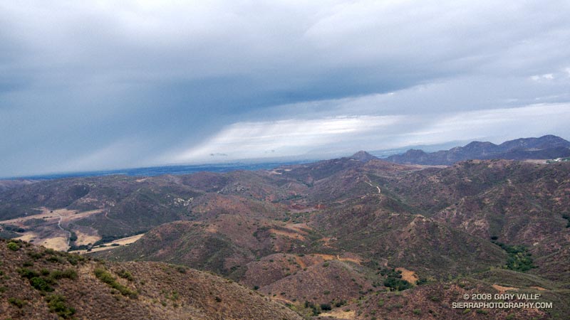
Following are brief descriptions, Google Earth images, and a Google Earth KMZ file of several trail runs at Ahmanson Ranch — now Upper Las Virgenes Canyon Open Space Preserve. These are shorter courses, generally on dirt roads, that extend as far west as Las Virgenes Canyon. Some longer runs in this area are listed in the Santa Monica Mountain Conservancy Open Space section of my Google Earth KMZ Files of Trail Runs page.

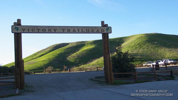
The distances and elevation gains/losses specified are for a round-trip from the Victory trailhead, and are approximate. Any of the courses can be lengthened by 2.6 miles by starting at the El Escorpion Park trailhead at the west end of Vanowen. This also adds about 350′ of elevation gain/loss.

To simplify labeling the courses, the main (dirt) road between the Victory trailhead and Las Virgenes Canyon is referred to as the “Main Drag.” This term was coined by long-time Ahmanson runner Jon Sutherland. The Upper Las Virgenes Canyon Open Space Preserve map refers to this road as the East Las Virgenes Canyon Trail. The road also has been designated a segment of the Juan Bautista De Anza National Historic Trail.

Here is the Google Earth KMZ file for the trail runs described below. To avoid clutter, when the file is opened in Google Earth, only two of the courses are initially displayed. Additional runs and variations can be viewed by clicking on the checkbox for the course.

If you are new to running at Ahmanson, a couple of things to watch out for are rattlesnakes and the heat. It also gets very muddy when it rains. Enough talking, let’s get to running…

Lasky Mesa Mary Wiesbrock Loop (3.7 mi, 270′ gain/loss)

Of the courses listed, this run has the least amount of elevation gain. Following a short stretch of downhill, the route does a big switchback and climbs up to the eastern shoulder of Lasky Mesa. The climb is fairly moderate, but comes early in the run. About 1.2 miles from the Victory parking lot is a “Y” junction, marked by some rocks and a trashcan. (A pair of ravens also like to hang out here.) This is the start of the 1.3 mile loop that honors Mary Wiesbrock, whose tireless efforts helped save Ahmanson Ranch from development.

If you do the loop counterclockwise, taking the right fork at the “Y,” in about 0.6 mile the Mary Wiesbrock loop turns left (south) onto a connector road. This leads to a “T” junction and the southern leg of the loop. A left turn at the “T” continues east through grassland to some ranch buildings, and another left leads back to the “Y” at the start of the loop. All of the loop is on dirt road, and there are some trail markers.

If you miss the turn onto the north-south connector, the north road continues to an overlook at a prominent Valley Oak on the western end of Lasky Mesa. From this point the extension of the south road can be used to return to the standard route and the “Y” junction. This extended version of the Mary Wiesbrock loop increases the length of the course to 4.25 miles.

Main Drag – Lasky Mesa Loop (3.7 mi 380′ gain/loss)

Except for a short stretch at its beginning and end this course is a complete loop. It starts the same as the Lasky Mesa Mary Wiesbrock Loop, but instead of turning left up the big switchback, it turns right onto the Main Drag.  Here, the road curves downhill and then turns west. After passing through a grassy riparian area, the road climbs a short hill and continues westward.

About a mile from the parking lot, a prominent oak tree can be seen on the crest of hill, directly south of the road. This is the “lollipop tree.” In about a tenth of a mile, at a junction with a trashcan and trail marker, this course forks left (south) off the Main Drag , and drops down to another grassy riparian area along the main drainage of East Las Virgenes Canyon. From here the road climbs about 1/2 mile up to Lasky Mesa.

At the top of the climb the road intersects the northern leg of the Mary Wiesbrock Loop. There are three route choices here. This course curves left (east), and then forks left and follows the winding road along the scenic northern edge of Lasky Mesa through valley oaks to the “Y” junction of the Mary Wiesbrock Loop. From here it’s a little over a mile back to the parking lot.

A slightly longer variation also curves left at the top of the hill, but forks right and continues south up a short grade. This leads to a “T” junction and the southern leg of the Mary Wiesbrock Loop. Continuing on the loop counterclockwise, this variation circuits Lasky Mesa’s grasslands around to the same “Y” junction as the standard course.

The third, and longest, variation turns right at the top of the long climb, and does the extended version of the Mary Wiesbrock Loop counterclockwise around the mesa to the “Y” junction.

There is also a scenic 3.3 mile variation that branches from the standard route in the grassy area just before the long climb, and ascends a well-used single track southeast to Lasky Mesa just west of the “Y” junction of the Mary Wiesbrock Loop. A left turn (east) here leads to the “Y” junction in about 200 yards.

Out & Back to Las Virgenes Canyon (5.3 mi,  465′ gain/loss)

This course starts the same as the Main Drag – Lasky Mesa Loop, but instead of turning left a little past the Lollipop tree, it continues west on the Main Drag all the way to Las Virgenes Canyon.

This is a good course for a tempo run — particularly the out leg to Las Virgenes Canyon. When the weather is hot the return leg (gradual uphill, often with the wind) can be tough.

If this run is extended to the Las Virgenes Rd. Trailhead it adds about 0.8 mile to the out and back course.

Las Virgenes Keyhole Loop (6.6 mi, 625′ gain/loss)

This is an excellent and varied course that loops through Las Virgenes Canyon and crosses Las Virgenes Creek twice. Following Winter rains you might even get your shoes wet!

The run starts the same as the Out & Back to Las Virgenes Canyon, but turns right (north) off the Main Drag at a junction (with a trashcan) at about the two mile point. From here, it is about a mile to Las Virgenes Canyon, and another mile down the canyon to the turn back onto the Main Drag.

There is a 7.3 mile variation of this course that turns south off the Main Drag about 1/3 mile east of Las Virgenes Canyon and follows a pipeline service road up to the western end of Lasky Mesa. This climb is known as “The Beast.” Some other roads/trails in this immediate area are posted “Restoration Area — Please Keep Out” so be sure you’re on the right trail.

Hawk, Bobcat and Rabbit

Ka-ree… Ka-ree… Ka-ree…

I heard the angry cries at least a quarter-mile away. The screams were incessant. Running along the dirt road, I emerged from a grove of oaks and turned west — running down a short hill and then up another. Cresting the rise, I paused to search the parched terrain.

The Winter rain season had been the driest on record, and Summer heat was now oppressive, abusing the animals and desiccating the chaparral. A few clouds cluttered the sky, but they would bring no rain. The cries continued.

Ka-ree… Ka-ree… Ka-ree…

The screams seemed to be coming from a group of rocks and oak trees near the campground. I left the road and slowly walked through the brush in the direction of the shrill shrieks. As I approached, the intensity and urgency of the screams increased. Intimidated, I stopped.

KA-REE… KA-REE… KA-REE…

There was not only fury in those cries, but a warning.

To my left, something stirred. Slowly I turned and looked down. For a moment I just stared. Rabbit lay face-down against a rock, twitching. Up in the oak tree, Hawk continued his irate cries.


KA-REE… KA-REE… KA-REE…

Suddenly, there was motion to my right, and Bobcat bolted from the brush. Hawk swooped in pursuit. His broad tail flared and wings twisted one direction and then another, as he followed the abrupt zigs and zags of Bobcat through the rocks, up the hill, and out of view.


KA-REE… KA-REE… Ka-ree… ka-ree…

Afterward: This encounter occurred during a run at Sage Ranch Park in July of 2002. I continued my run, and when I returned about 30-40 minutes later, the rabbit was gone. The photographs were taken during the encounter.