Heat Training Hold

Warming Hut and Golden Gate Bridge at sunrise from the Golden Gate Promenade

I squeezed the bag of ice wrapped in the bandanna around my neck and shivered as an ice cold bead of water snaked down my spine. The temperature reading from the shaded sensor clipped to my pack read 106°F.

Sunrise from the Golden Gate Promenade near the Warming Hut and Fort Point Pier, also known as Torpedo Wharf.
Sunrise on Golden Gate Promenade near Fort Point Pier

That had been at 3:30 Thursday afternoon at Ahmanson Ranch. Earlier that day the “in the sun” temp recorded at the nearby Cheeseboro RAWS had topped out at a blistering 119°F!

This morning, Sunday morning, my AC100 heat training was on hold. The sun had just risen and I was running on the dew-covered sidewalk of the Golden Gate Bridge. The temperature sensor was reading about 54 degrees cooler than at Ahmanson — an almost chilly 52°F.

Not to worry — I would be back running in the 100 degree Ahmanson heat Tuesday.

Deer Encounters

Mule deer near Trippet Ranch in the Santa Monica Mountains

Mule deer are common in the Santa Monica Mountains. I see them most frequently in Topanga State Park, near Trippet Ranch, and in Malibu Creek State Park.

This video snapshot is of a recent encounter with three mule deer while running down Eagle Springs Fire Road to Trippet Ranch.

My intent was to try and walk past without scaring them. One doe did not run, but the youngster and its companion were more skittish and didn’t quite know how to react.

In some situations a bolting deer can be a real problem. Two friends running in Topanga State Park rounded a corner and were suddenly confronted with a spooked buck running toward them. There was a steep hill on one side and a cliff on the other. In the narrow confines the buck collided with one of the runners, hitting his shoulder and knocking him to the ground. All things considered he was very lucky. The bucks head was up, so the collision only resulted in a sore shoulder and some trail rash.

Some related posts: Trippet Ranch Mule Deer, Musch Trail Mule Deer

Crest and Clouds

Crest and clouds on the Pacific Crest Trail at 8900' near Mt. Burnham.

Crest and clouds on the Pacific Crest Trail at 8900′ near Mt. Burnham in the San Gabriel Mountains. From Saturday’s 30 mile training run on the PCT and AC100 course.

Cirrocumulus undulatus clouds above the San Gabriel Mountains. June 18, 2016.
Cirrocumulus undulatus clouds

Temps were a bit more manageable on Saturday than Sunday. Saturday the Big Pines RAWS (6964′) recorded a high of 79°F with an “in the sun” temperature of around 101°F. Sunday the Big Pines high was 89°F with a sizzling “in the sun” temperature of about 109°F.

In addition to the air temperature many Remote Automated Weather Stations (RAWS) report the fuel temperature. The air temperature is the temperature inside a ventilated, sun-shielded enclosure approximately 6 ft. off the ground. The fuel temperature is the temperature of a pine dowel in full sun near the ground. The fuel temperature is a good indicator of the much higher temperature runners and hikers can experience in exposed areas facing the sun.

Some related posts: Postcard Weather on the Pacific Crest Trail, What’s the Current Weather on the AC100 Course?

Crissy Field – Fort Point – Land’s End – Golden Gate Park Loop

Monterey pines in Land's End Park

What do a hilly marathon, a pair of cygnets, and a herd of bison have in common?

Why, of course, a run in San Francisco.

Crissy Field and the Golden Gate Promenade

Brett wanted to check out some of the hills on the San Francisco Marathon course and show me more San Francisco sights. The result was a 14 mile loop that began in the Marina District and visited Crissy Field, the Golden Gate Bridge at Fort Point, Land’s End Park, Sutro Heights Park and Golden Gate Park.

The Palace of Fine Art swanskeep a close eye on their brood. June 4, 2016.
Blanche, Blue Boy and their cygnets

The run started with a visit to the Palace of Fine Arts to check on Blanche’s and Blue Boy’s new brood. Nature isn’t always nice, so it was good to see the remaining two cygnets are doing well.

One of two lion statues at the entrance to Sutro Heights Park.
Sutro Heights Park Lion

Most of the run between the Golden Gate Bridge and Golden Gate Park was on the California Coastal Trail. Near Sea Cliff we left the marathon course and continued on the Coastal Trail to Land’s End Park and Sutro Heights Park, eventually entering Golden Gate Park on its northwest corner at 47th Avenue.

Bison in Golden Gate Park

Larger than New York’s Central Park, Golden Gate Park’s many attractions draw millions of visitors each year. That one of those attractions is a golf course isn’t particularly surprising. And you might expect a major city park to have a botanical garden, aquarium and a museum. But would you expect a park in San Francisco to host a herd of bison? I know when I put on my running shoes this morning I wasn’t thinking, “Hope we see some buffalo!”

Bison have been present in Golden Gate Park since the 1890s. According to this Huffington Post article by Fiona Ma the herd was repopulated in 2011 and, “The City and County of San Francisco would excitedly welcome 6 more urban bison members.”

The title photo is a black and white image of Monterey pines along the Land’s End Trail.

Some related posts: San Francisco Sights Trail Run, Golden Gate Bridge Run, Miwok Wanderings

Postcard Weather on the Pacific Crest Trail

Mt. Baden-Powell from the PCT on Blue Ridge

In recent weeks it seems just about every weekend the mountains have had postcard running weather.

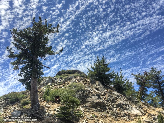
Today’s run was on a higher elevation section of the Pacific Crest Trail and Angeles Crest 100 course. To shorten the shuttle, but still enjoy the great views up on Blue Ridge, we parked at Inspiration Point and started the day with a six mile (round trip) out and back run to near Blue Ridge Campground.

After the out and back run and a quick stop at the car, we continued west on the northbound PCT to Vincent Gap, then up to the summit of Mt. Baden-Powell, down to Islip Saddle, up and over the shoulder of Mt. Williamson and then down to Eagles Roost.

PCTA volunteer Ray Drasher has been hard at work again, clearing fallen trees from the trail on Blue Ridge, Lytle Ridge and between Mt. Hawkins and Islip Saddle; and PCTA trail maintenance sage Pete Fish and another volunteer took care of the two trees on the west side of Williamson. Thanks!

During the run the following question came up — What is the highest elevation reached by the PCT in Southern California? It had to be either on San Jacinto Peak or Mt. Baden-Powell. I knew the high point of the PCT on Baden-Powell was around 9200′, but couldn’t recall the max elevation of the PCT on San Jacinto. We asked a through-hiker and he said about 9000′.

When I got home I checked the elevations using USGS National Map 1/3 arc second digital elevation model data. According to this data the high point of the PCT in Southern California is 9230′, at the junction of the PCT and Mt. Baden-Powell summit trail. The max elevation of the PCT on San Jacinto Peak is 9045′, near the junction of the PCT and Wellman Divide Trail.

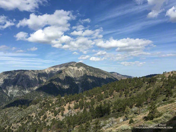
The title photo is Mt. Baden-Powell from the PCT east of Inspiration Point.

Photography and inspiration from running and other adventures in the Open Space and Wilderness areas of California, and beyond. No ads. All content, including photography, is Copyright © 2006-2025 Gary Valle. All Rights Reserved.