Tag Archives: wildflowers

Trying to Use AI to Solve a Malibu Creek State Park Plant Mystery

Terminal leaf cluster of Purple Clarkia (Clarkia purpurea), after it has flowered.

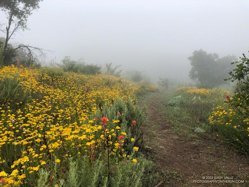
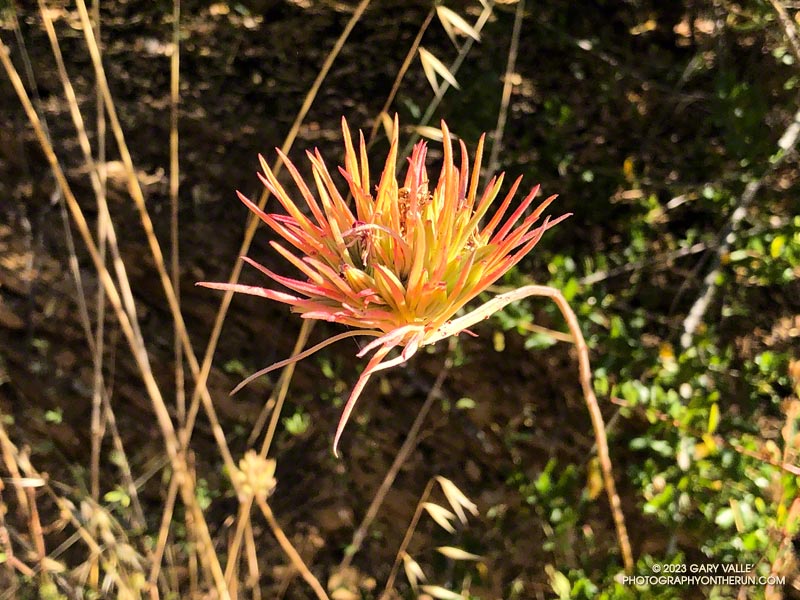
Recently, while doing the Bulldog Loop in Malibu Creek State Park, I noticed a peculiar plant about a half-mile up the Bulldog climb. The linear, red-tinged “petals” were unusual in the early morning light. I snapped a photo of it, planning to identify it later.

When I looked at the photo later that day, I couldn’t ID the plant. Hoping to get some hint about its identity, I tried various “AI-powered” searches and apps. This included Google Lens, Bing Visual Search, Pl@ntNet, iNaturalist Seek, PlantSnap, Flora Incognita, LeafSnap, and others. The most common matches were air plants such as Tillandsia ionantha and various species of paintbrush.

This wasn’t a huge surprise. The AI-based applications were having the same problems I was having — they were not “familiar” with this particular stage of the plant’s life cycle. They also were not keying on an important element of the image.

After a few days without any progress identifying the plant, I headed back to Malibu Creek State Park to take a closer look at the plant.

That turned out to be more challenging than expected. Even though I had the plant’s GPS coordinates, the time of day was different, with different lighting. The plant was also less colorful than before. I walked up and down a 30-yard stretch of Bulldog fire road several times before finally seeing it.

Once located, it didn’t take long to find examples of the plant at an earlier stage of development. In one case, with leaves on the stem and another with leaves and a flower. This helped solve the mystery.

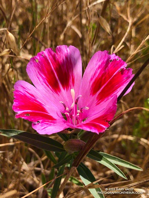
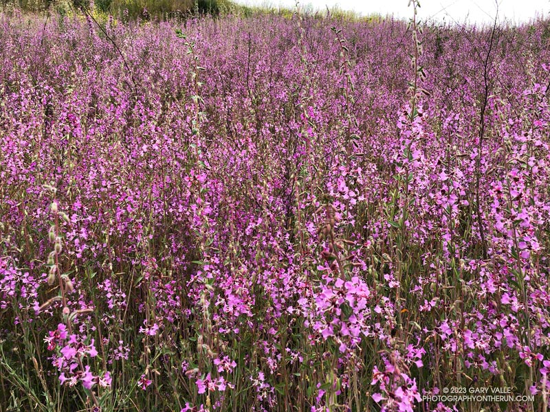
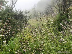
It turned out the plant was one with which I was familiar — Purple Clarkia (Clarkia purpurea). The title photo is after the plant has flowered and all but a terminal cluster of leaves on the stem have wilted. The 8-grooved, elongated-football-shaped structures intermixed with the leaves are ovaries. These are distinctive. A human expert would have immediately zeroed in on these.

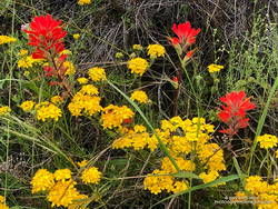
The flowers of Purple Clarkia are usually much larger than seen here. They are typically purple-pink with a wine-red spot on each of the four petals. However, the color of the flowers varies, and wine-colored flowers are not uncommon. The size of the flower also varies. Jepson mentions that the subspecies intergrade extensively.

Using the photo of the plant in flower, some of the AI-based apps identified the genus as Clarkia and/or the species as purpurea, or at least included Clarkia among their suggestions.

Farewell-to-Spring in Upper Las Virgenes Canyon Open Space Preserve

Farewell-to-Spring found in Upper Las Virgenes Canyon Open Space Preserve in June 2023

An unusually wet rain season not only increases the population of many wildflowers, it can produce wildflowers not usually seen in an area.

The Farewell to Spring (Clarkia amoena) pictured above was one of very small population found in Upper Las Virgenes Canyon Open Space Preserve (aka Ahmanson Ranch) in June 2023. The California native is much more common in the Bay Area and coastal Northern California. It probably found its way to Ahmanson by way of a local garden.

Elegant Clarkia in Las Virgenes Canyon

Hillside of Elegant Clarkia in Upper Las Virgenes Canyon Open Space Preserve (aka Ahmanson Ranch)

This year’s bloom of Elegant Clarkia (Clarkia unguiculata) in Upper Las Virgenes Canyon Open Space Preserve (aka Ahmanson Ranch) is even more widespread and lavish than it was in Spring 2020. It’s virtually impossible to do a hike, run, or ride at Ahmanson Ranch and not see the stalks of the oddly-shaped, 4-petaled, pink-purple flowers.

As in 2020, Purple Clarkia (Clarkia purpurea) is also widespread. Not as common at Ahmanson Ranch is another member of the Evening Primrose Family, Shredding Primrose (Eremothera boothii). It can be found along the Edison service road near the Las Virgenes Trailhead.

After the Bobcat Fire: Running the ANFTR 25K Course

San Gabriel Mountains. Photography by Gary Valle'.

On June 1, Angeles National Forest reduced the size of the Bobcat Fire Closure, opening up most of the upper West Fork San Gabriel River area. Curious to see how the West Fork area is recovering from the Bobcat Fire, today I ran a slightly shortened version of the ANFTR/Mt. Disappointment 25K course.

Since the Mt. Wilson parking lot is usually closed until mid-morning, this morning’s run started and ended at a small turnout near the top of the Kenyon Devore Trail on the loop road on Mt. Wilson. The ANFTR Trail Races start at the main Mt. Wilson parking lot.

I’d recently done the San Gabriel Peak and Bill Riley Trails and knew they were in reasonable condition. And I’d read that AC100 Trail Work Teams led by Gary Hilliard and Ken Hamada had cleared the Gabrielino and Kenyon Devore Trails earlier this year. So, I didn’t expect to have a repeat of the epic fallen-tree obstacle course that I experienced doing this course in 2020.

Here’s a slideshow of what I found.

Explore the scenery and terrain of the Mt. Wilson – Red Box – West Fork – Kenyon Devore Loop using our high resolution,  interactive, 3D viewer. The imagery is so detailed, it’s almost like being there! The loop is a slightly shorter version of the ANFTR 25K. To change the view, use the control on the upper right side of the screen, the CTRL key and your mouse, or touch gestures. Track and placename locations are approximate and subject to errors. Snow, ice, poor weather, and other conditions may make this route unsuitable for this activity.

Related post: An ANFTR/Mt. Disappointment 2020 Adventure

Yellow Mariposa Lilies Along the Chumash Trail

Yellow mariposa lilies along the Chumash Trail in Simi Valley.

The bloom of Yellow Mariposa Lily along the Chumash Trail in Simi Valley has been extraordinary this year. Above, it is pictured with Golden Stars.

Among the multitude of wildflowers blooming along the trail this May were the showy Butterfly Mariposa Lily and intensely blue Parry’s Larkspur.

Relate post: Marr Ranch Wildflowers

A Really Overgrown Trail, Thirty Creek Crossings, and Thousands of Wildflowers

Yarrow and paintbrush along the Old Boney Trail in Pt. Mugu State Park.
Old Boney Trail in Pt. Mugu State Park.

Starting at the Wendy Drive Trailhead, I’d crossed Satwiwa, run down Danielson Road, rock-hopped across Upper Sycamore Creek, and picked up the Old Boney Trail. The condition of the Old Boney Trail between Danielson Road and the Fossil Trail junction was better than expected. Maybe the trail was going to be in good shape after all.

A section of the Old Boney Trail overgrown with black sage following the wet rain season of 2022-2023.
A section of the Old Boney Trail overgrown with black sage.

Wrong! Once I passed the turnoff to the Fossil Trail, the vegetation closed in. In places it was so thick I couldn’t see the trail at my feet, much less a few yards ahead. All I could do is smile and work my way through it. Everything was overgrown — bushes, grasses, wildflowers. And everything was wet with dew. A hundred yards past the Fossil Trail, I was soaked from head to toe.

I tried to see the positive. It was an amazing display of the effect of a wet rainy season. Without trail work and use, it wouldn’t take long for the trail to be completely consumed.

The Old Boney Trail continued to be a tangle of chaparral for about two miles — until I reached the Backbone Trail at Blue Canyon. At that point, it becomes part of the Backbone Trail system, and I was relieved to see that some work had recently been done on the trail.

Coast live oak and fog along the Old Boney Trail in Pt. Mugu State Park.
Coast live oak along the Old Boney Trail.

As I worked up the Backbone Trail toward the Chamberlain Trail junction, I recalled other times I’d run to Serrano Valley using Old Boney. What would the condition of the trail be beyond this point? I’d been on that part of the Old Boney Trail following a wet rain season and knew how overgrown it could be. Some refer to that section of trail as “tick alley.”

But when I got to the junction, surprise, surprise, the Old Boney Trail had been trimmed. More than two miles of trail were groomed. It was good all the way to the Serrano Valley Trail and partway into Serrano Valley. The trail in Serrano Valley was a little overgrown, but NOTHING like the Old Boney Trail between the Fossil and Backbone Trails.

Part of the fun of doing this route is all the stream crossings in Serrano Canyon — what is it 13 or 14? Today, most of these could be done without getting your shoes wet — especially if you have poles. I didn’t have poles, and my shoes and socks were already wet, so I didn’t worry about keeping them dry. Some sections of the Serrano Canyon Trail were also overgrown, but not bad. However, there was a lot of poison oak, some of which wasn’t avoidable.

Paintbrush and golden yarrow along Sycamore Canyon Fire Road in Pt. Mugu State Park.
Paintbrush and golden yarrow

After getting a drink of water at the faucet at the junction of the Serrano Canyon Trail and Sycamore Canyon Fire Road, I headed up-canyon. Almost immediately, the fire road crossed Big Sycamore Canyon Creek. I did this first crossing without getting my shoes wet, but nine more crossings followed, and most resulted in soaked shoes. The water crossings and wildflowers helped distract me from the five mile run up Sycamore Canyon to the Upper Sycamore Trail.

Getting off Sycamore Canyon Road and onto the Upper Sycamore Trail was a relief. Whatever run I do from Wendy Drive, I always finish it via this trail. The trail gets enough use that it was in good shape. This time all the creek crossings could easily be rock-hopped.

Even with a few tedious sections, it was an adventurous and mostly enjoyable 20 miles. Here are some photos taken along the way.

Some related posts: Old Boney to Serrano Valley, Plus Fireline and Overlook; Looking for Ogres in Serrano Canyon; Running to Serrano and La Jolla Valleys from Wendy Drive; You Can’t Run Just Part Way Up Serrano Canyon