Category Archives: photography|trail running

Air Conditioning

Nearing the summit area of Mt. Pinos

Enjoyed a combination Father’s Day & July 4th visit from Brett over the weekend. Friday we did a fun run at Malibu Creek State Park and today we headed up to Mt. Pinos to get in a cooler, higher altitude run.


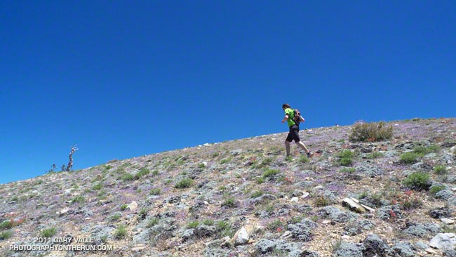
In addition to Mt. Pinos (8831′), there are three other peaks along the broad ridge traversed by the Vincent Tumamait Trail — Sawmill Mountain (8818′), Grouse Mountain (8582′), and Mt. Abel/Cerro Noroeste (8280+’). I’ve run past the indistinct path to Grouse Mountain numerous times on the way to Mt. Abel, always commenting “someday I have to check that out.” Finally, today we did.

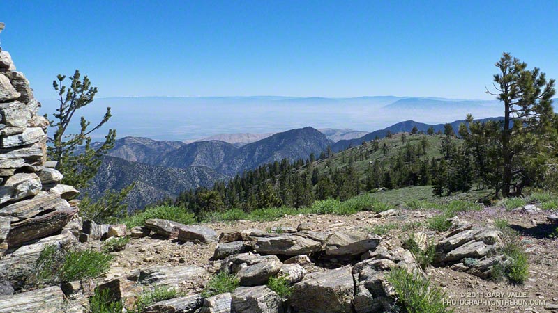
On the way to Grouse we did the short detour to the top of Sawmill. Since my last visit the Chumash spirit tower on the peak had grown, no doubt from the many fine days and views enjoyed here. This morning the snow-covered mountains of the Southern Sierra could be seen above the haze of the San Joaquin Valley.


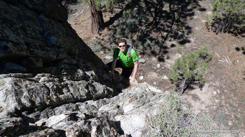
The ascent of Grouse was straightforward. Like Sawmill Mountain, it has two nearly equal height summits. We found a small granite crag northeast of the summit and climbed a short steep route on its west face. It had fun technical moves on mostly good holds, but in running shoes you had to pay attention — especially on the downclimb!

On the way back to Mt. Pinos we stopped by Sheep Camp. The short side trip to this idyllic spot is essentially compulsory. It would be easy to spend the afternoon here, listening to the wind in the pines and the gurgling of the spring; smelling the sun-warmed pine needles; and enjoying the greens, yellows, reds and blues of Summer.

I always feel a little twinge of regret when leaving Sheep Camp, but it was a great day to be on the move, and soon we were back on the trail and enjoying that as well.
 
Some related posts: Vincent Tumamait Trail, Atmospheric Dynamics

Bandit 50K 2011 Notes

50K runners climbing up Rocky Peak road.

50K Runners Returning from the Rocky Peak Trailhead

Cool temps, clearing skies, and snowy vistas greeted runners doing the 2011 edition of the Bandit trail races at Corriganville Park in Simi Valley, California.

If you’re going to have a trail race after a rainstorm, Rocky Peak is the place to do it. Rain gauges in the area recorded as much as two inches of rain in the 48 hours leading up to the race, and for a while it looked like there might be a dusting of snow on the highest points of the course. Except for a couple of short muddy sections, and having to dodge a few mud puddles, the dirt roads and trails were in good shape.

This year the race was expanded to include a 50K. This new option doubled the fun on the Chumash-Las Llajas loop of the 30K course, running the loop twice, and also took a short sightseeing trip down to the Rocky Peak trailhead at Santa Susana Pass. The 30K course was the same as last year, but the 15K course was shortened from last year’s 16K or so to 15K.


The 50K course is a tough one, including about 7 miles of technical single track trail, 22 miles of fire road, and a mile of paved road. The elevation gain/loss is about 5400′, which is a little more than the Bulldog 50K course, and a little less than the original Mt. Disappointment 50K course. Here’s an elevation profile of the Bandit 50K course.

There are several difficult stretches on the 50K course. Just a mile into the race runners have to deal with a very steep climb — an 800 foot ascent in just one mile. In my mind it’s the most important mile on the course, and how hard you push here can have a big effect on how you feel over the next 28 miles! There are a couple of other long climbs. The 2.3 mile climb from the Rocky Peak trailhead to the top of the Rocky Peak grade gains over 1000′, and the gain over the 1.75 miles from the Las Llajas split to the highpoint at Shells/Fossil Point is 800′. Runners doing the 50K get to do the Las Llajas to Shells climb twice.


One of the toughest sections for me was the run up Las Llajas Canyon on the second Chumash-Las Llajas loop. This section starts at about mile 19 and ends at the Las Llajas split, where the road forks right and up through the oil fields. For the most part the grade is not steep, but the miles are deceptively long and grueling. Also tough on tired legs is the very technical plunge back down to Corriganville at the end of the race.

Congrats to 50K winners Chris Price and Nancy Ishizawa. Clearly enjoying the day, Chris flew through course in a remarkable time of 4:12:51, averaging 8:28 minute miles. In the 30K Marcelo Mejia set a new course record with a blazing time of 2:52:31. On a slightly shorter course than last year, Fernando Ramirez and Jen Todd put down fast 15K times. For all the results and race photos, see the Bandit web site.

All in all it was fantastic day for a run! Many thanks to the race organizers — Randy & Sarita Shoemaker, Larry Lee, and Todd Baker — and all the volunteers and sponsors for an outstanding event!

Here are a few additional photos. Click for a larger image and description:


Start of 800′ Corriganville Climb


Running Up from Rocky Peak Trailhead


Snow on Ventura Mountains


15K Runner Headed Back


Descending Chumash


Casey’s Water Cache

Bandit Training

Top of the Wildlife Corridor Trail

What a difference 5 days makes! In the cold morning shadows before the start of the Boney Mountain race last Sunday, the dew on the fences was frozen and frost was everywhere. This morning in Corriganville Park the temperature was a balmy 65 or so, and the high was expected to be around eighty.

Today I was running the Bandit 30K course as part of a training run organized by Bandit 15K/30K/50K R.D. Randy Shoemaker. Good thing too. Even though these are my backyard trails, it reminded me just how tough these courses are. The numbers — about 3300 ft. of gain/loss over 19.5 miles for the 30K — don’t tell the whole story.


The title photograph is of runners at the top of the Wildlife Corridor Trail. This gnarly trail links Corriganville Park to Rocky Peak Road, and it is just one of the special treats you’ll encounter on the 15K, 30K and 50K courses. I don’t know if it tougher going up, when your legs are fresh; or going down, when your legs are worked. From personal experience I know it is really easy to push too hard on this climb, and mutter to yourself, “Why did I do that?” for the remainder of the race.

Today, the conditions could not have been better. Well, if we’re going to nitpick, maybe a little less wind. But who can complain on a January day when skies are blue, the hills are green, and the temperature is in the seventies?

Christmas Eve Trail Run

As much rain as we’ve had in Southern California, we’ve still seen some stunning December days with blue skies, pleasant temperatures, and sensational trail running.


Today I was running with Frank and Lynn. They’re visiting from the Pacific Northwest, where the amount of rain has been more or less normal, and spending Christmas in Southern California, where — you know — we’ve had the wettest December in 121 years.

More rain was forecast for late Christmas Day, but today we were between storms. To celebrate the wonderful Christmas Eve weather we did the 21 mile Will Rogers – Temescal loop from Marvin Braude Mulholland Gateway Park in the San Fernando Valley.


The run is a Santa Monica Mountain classic, descending from the crest of the range along one long ridge nearly to the coast, and then ascending back to the crest on another. The views along the ridges are boundless, encompassing the Ventura Mountains, San Fernando Valley, San Gabriel Mountains, San Bernardino Mountains, Saddleback, downtown Los Angeles, Westwood, Santa Monica, Catalina and more.

Today, the high peaks east of the basin were capped by new snow, and in addition to Mt. Baldy, it was easy pick out San Bernardino Peak, far to the east. From near Skull Rock, Santa Monica Bay glittered in the sun, the shore of the Pacific extending in a graceful arc to Palos Verdes Peninsula and Catalina.

There were the usual muddy and wet sections that follow a good rainstorm, but other than one small rock and mud slide on the Rivas Canyon Trail, the trails were in surprisingly good shape. It was an outstanding run!

Some related posts: Will Rogers – Temescal Loop, Will Rogers Western Ranch House, Los Angeles Basin Fog

Mt. Disappointment 50K 2010 Notes

Mt. Disappointment 50K 2010

Note: The Mt. Disappointment Endurance Run is now the Angeles National Forest Trail Race.

The most remarkable thing about this year’s Mt. Disappointment Endurance run is that there was a 2010 race. The Station Fire and heavy Winter rains decimated the San Gabriel Mountains. Without the hard work and dedication of Gary & Pam Hilliard and a host of volunteers the 6th edition of the race never would have happened.


There were some changes in the course. After descending from Mt. Wilson to Red Box, the 50K course normally goes down to Clear Creek Station, circuits Strawberry Peak, and then returns to Red Box. Not this year. The Colby Canyon and Strawberry Trails were particularly hard hit by rock slides and washouts, and could not be used.  Instead, after running down to Red Box, we hung a right and continued down Red Box Road to the West Fork aid station. Usually done after mile 20, it was great to run this segment while it was still cool, and I had some life left in my legs.

At West Fork, after ten miles of downhill and losing 2600′ in elevation, the infamous 16 mile Shortcut loop begins. Usually part of the Mt. Dis 50 mile course, the Shortcut loop is best known for it’s scorching 5.6 mile, 2000′ climb up Edison Road to Shortcut Saddle. It’s one of those climbs that doesn’t look that bad on paper, but a topo map doesn’t show the sun beating down on your head mile, after mile, after mile. Fortunately, the weather was kind. The high on Mt. Wilson only reached 73 degrees — several degrees cooler than the usual temperature for this race.


Wow, the Edison climb and the Kenyon Devore climb all in one 50K! But what are two classic climbs without a tough descent in between? The Silver Moccasin Trail between Shortcut and West Fork was obliterated by slides, debris flows and flash flooding. Hours and hours of work were done on the trail to make it passable. In the lower half of the canyon, flooding and debris flows widened the streambed, making it difficult to connect the remnants of old trail into a recognizable path. The challenge wasn’t staying on the course, it was very well marked, but trying to pick the best route through a maze of sand, stream, cobble, and bits and pieces of the old trail.

Then came the Kenyon Devore climb.  After doing 10 miles of fast-paced downhill, the Edison climb, and the Silver Moccasin rock dance, the ascent of Kenyon Devore was not easy! But it never is! There were a couple of newly fallen trees to clamber over, and some other challenges, but all-in-all it was the same classic climb.


To borrow an old rock climbing quip, an endurance run “ain’t no weenie roast,” and this year the Mt. Disappointment 50K was just a bit  more of a challenge. Here’s an elevation profile, and a Cesium browser View of a GPS trace of the course. In SportTracks my trace of the course worked out to about 31.6 miles. This is a mile or so shorter than the web site mileage because Mueller Tunnel was closed and we skipped the Mt. Disappointment section. The mileages in the Google Earth view are from my trace of the course, and may not be accurate.

Congrats to the overall Men’s and Women’s winners Patrick Sweeny (4:40:46) and Sada Crawford (5:28:17). Patrick ran the race in Vibram Five Finger KSO Trek’s. Check out all the results on the Mt. Disappointment web site!

Here are a few photos. Click for a larger image and description:


Salomon XT Wings 2 Trail Running Shoe

Salomon XT Wings 2 Trail Running Shoe

Wow — what a great ride! That was my impression the first time I used the Salomon XT Wings trail running shoe, and seven pairs and a couple thousand miles later, the XT Wings is still my shoe of choice for longer trail runs. Now the shoe has been upgraded to the XT Wings 2, and the good news is Salomon listened to the feedback from runners, and made a very good shoe even better.


XT Wings Comparison
One of the most obvious changes in the XT Wings 2 is the change from an asymmetric speed-lacing system that would sometimes fray, to a symmetric speed-lacing system with lower friction eyelets. None of my Salomon trail shoes with symmetric lacing have had lace-fraying issues, and these new laces look bombproof!

Update 07/05/10. I now have about 190 miles on each of three pairs of Salomons with the the new eyelets (XT Wings, XT Wings 2 & XT Hawk 2), and I’ve had no problems with the laces fraying.

Not so obvious until you run in the shoe is the redesign of the toe cap to increase flexibility. I thought the gait transition was smooth in the original XT Wings, and it is even better now. I was also happy to find that my new pair of XT Wings 2 (US Size 9.0) weigh 26 oz., which is a bit less than my first pair of XT Wings.

The shoes felt great on Sunday’s Trippet Ranch loop; they had that familiar XT Wings’ combination of comfort, smooth ride, cushioning, traction and support.

Related posts: Salomon XT Hawk 2, Salomon XT Wings