El Nino Drought

Grasslands west of Rocketdyne in the Simi Hills.

The open space areas in which I run would normally be lush and green by this time of year, particularly when there is an El Niño. But in the past 231 days (including today) the official weather station for Los Angeles has recorded only 1.31 inches of rain, and the hills remain a dank sun bleached gray-brown.

As mentioned in my post The Color of Rain, usually when there’s an El Niño, wet Winter weather can be expected to occur in Southern California. This year’s El Nino was late to develop, became stronger than expected, and may have already peaked.

Warm water in the tropical western Pacific contributes to the development of an El Niño, and studies show this pool of warm water has been increasing in temperature, perhaps increasing the strength and frequency of El Nino’s. The quirkiness of this year’s El Niño may be related to these changes.

Is any relief to our drought in sight? Not in the short term. A system forecast to affect the Los Angeles area Thursday and Friday will likely result in cooler temperatures and more wind, but little – if any – rain*.

In his blog Atmospheric Insights, NWS scientist Ed Berry discusses the possibility of a high impact precipitation event developing in California later this January*. A flow pattern with a strong lower latitude jet stream is typically associated with El Niño induced precipitation events in California.

California weather this rain season will be closely monitored by scientists participating in NOAA’s Hydrometeorological Testbed (HMT) Program. This program is “aimed at accelerating the infusion of new technologies, models, and scientific results from the research community into daily forecasting operations of the National Weather Service (NWS) and its River Forecast Centers (RFCs).”

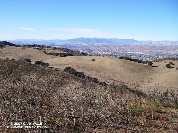
The photograph of the dry grasslands in the Simi Hills west of Rocketdyne was taken on a run to the northern boundary of the Upper Las Virgenes Open Space Preserve on December 24, 2006. The photograph of the green hills in the Ahmanson Ranch area of the Upper Las Virgenes Open Space Preserve is from a run on January 18, 2005.

*Updated 01/10/07. Today’s runs of the computer weather models are projecting from about 0.1 inch to 0.25 inch of rain from this system at Los Angeles. Also, see the January 10 update to Ed Berry’s Atmospheric Insights blog. Consolidation of the Pacific jet now appears unlikely, so we may not see typical El Nino impacts developing in California this month. There may be rain, but perhaps not as a result of a classic El Nino pattern. We’ll see!

Ahmanson Lollipop Tree

The Ahmanson lollipop tree can be seen on the skyline south of the main drag about 1.25 miles from the Victory trailhead.

On the South Fork American River is a tree high on a ridge that rafters and kayakers refer to as the Lollipop Tree. It marks the beginning of the Gorge run and the class III rapid “Fowler’s Rock.”

When I run on the “main drag” at Ahmanson Ranch (Upper Las Virgenes Open Space Preserve) there is an oak tree that sits on a hilltop near Laskey Mesa that reminds me of the S.F. American tree. The Ahmanson lollipop tree can be seen on the skyline south of the main drag about a mile from the Victory trailhead.

This photograph was taken on an exploratory out and back run to the headwaters of Las Virgenes Creek on Christmas Eve.

Note: Jon Sutherland nicknamed the main road that connects the Victory trailhead to Las Virgenes Canyon the “main drag.” Jon has run out at Ahmanson for more than 30 years. He is second on the Running Streak List for most consecutive days run. As of September 1, 2006 his streak was 13,613 consecutive days (37 years 99 days), and still counting!

Will Rogers – Temescal Loop

Mountain biker on the Will Rogers segment of the Backbone Trail in the Santa Monica Mountains

I paused for a moment on a narrow section of the Backbone Trail that zig-zags down a steep, eroded slope and then crosses a bridge over a narrow gorge before continuing down Rogers ridge. Below, a hiker stopped on the bridge to contemplate the canyon, and a mountain biker briefly walked his bike and then cranked up the switchbacks past me.

It had rained the day before, and the cold front had resulted in a chilly, puffy cloud, postcard kind of day with breezy panoramic views of the San Gabriel Mountains, Downtown, Century City, Santa Monica, Palos Verdes, and the Pacific Ocean.

The 7 mile segment of the Backbone Trail from Temescal Ridge fire road down to Will Rogers State Historic Park is one of my favorite (mostly) downhill stretches of trail in the Santa Monica Mountains. Over much of its length, the grade is not too steep, the footing consistent, and the running outstanding.

My usual route for this run starts the same as for the Trippet Ranch Loop and Garapito Figure 8 runs, going up to the Hub from the end of Reseda Blvd. From the Hub it’s about 0.6 mile along Temescal Ridge Fire Road to the point where the Backbone Trail takes off to the left from the road.

Once at Will Rogers, the Rivas Canyon Trail can be used to connect to Temescal Gateway Park, and then the Temescal Falls or Ridge trail used to connect with Temescal Ridge Fire Road and return to the Hub. (Mountain bikers use other routes.)

Overall the route is about 21 miles long, with about 3500′ in elevation gain/loss. Here’s an interactive, 3D terrain view of the Will Rogers – Temescal trail run from a more recent post.

Related post: Will Rogers – Rivas Canyon – Temescal Canyon Trail Run

Garmin Forerunner 205

Updated Monday, July 5, 2010.

The Google Earth image above shows two GPS traces. Here’s a larger image. The red trace was created using a Garmin Forerunner 201, and the yellow trace was created with a Forerunner 205. The course is comprised of a mix of fire roads and trails, through a variety of terrain and cover. The better tracking of the Forerunner 205 is clearly evident. Here is another view of the same course with the two traces.

I’ve had my Forerunner 205 since March 2006, and in my experience, it is a huge improvement over the 201:

  • It is more compact and less obtrusive.
  • Tracks are more accurate, and it almost never loses reception.
  • It accepts routes for sequential navigation.
  • Uploading and downloading data is easier and faster with the USB interface.
  • The GPS chipset firmware (as well as unit firmware) can be updated.
  • It has multiple customizable data screens that are easily displayed during a run.

The performance of the GPS receiver in the Forerunner 205 continues to amaze me. It is tenacious. I was wearing the Forerunner 205 when I got caught in a fierce thunderstorm running in the Mt. Pinos area in July. Even in the middle of a thunderstorm, on a north facing slope, in a fir and pine forest, the unit did not lose reception. Here’s a Forerunner 205 trace of the run, exported from TOPO! Note that the traces going out and coming back very nearly overlay each other. The only exception is a real deviation between Sawmill Mountain and Mt. Pinos where I wandered off the trail to a minor summit. Also note that the trail is incorrectly marked on the topo map in the vicinity of Grouse Mountain.

In early October 2006, I had a problem with not being able to power on my 205 after it was charged. Garmin promptly replaced the unit, under warranty, without charge.

In June 2007 the replaced unit began to experience an intermittent issue where it would suddenly start to rapidly cycle through display screens, beep, and not respond to key presses. The only way to stop it was pressing the power + mode + reset keys. Garmin promptly replaced the unit, but charged a flat rate $79 repair fee. Oddly, when the unit was returned, the history included a few runs from the London, Ontario (Canada) area from late February and early March 2007.

It’s been over three years since the flat rate repair/replacement of my Forerunner 205, and I’ve had zero problems. One apparent improvement is that the contacts on the back no longer get corroded from sweat. This used to cause problems with the USB connection and transferring data, and I would need to clean the contacts from time to time with a pencil eraser.

In my opinion the Training Center Software is still poor, and for that reason I continue to use SportTracks.

Note: The course is the run from the end of Reseda Blvd to Trippet Ranch described in the post Musch Trail Mule Deer.

The Color of Rain

Glistening in the morning sun, the wet trunk of a manzanita glows in iridescent shades of orange and red, pink and purple.

Glistening in the morning sun, the wet trunk of a manzanita glows in iridescent shades of orange and red, pink and purple. Decorated with raindrops, the chaparral, and all within, breathe a deep sigh of relief. It has rained!

Prior to Saturday night’s storm Los Angeles had recorded only 0.5 inch of rain in the last six months. Even by Southern California’s arid standards, this is a meager amount.

Usually when there’s an El Niño, wet Winter weather can be expected to develop in Southern California. But this year’s El Niño has been a little quirky, developing later than usual, and becoming stronger than expected. So far this Autumn, the weather here has been somewhat quirky as well, with record setting high temperatures and below average rainfall. An El Niño, even a strong one, does not guarantee wet weather in our area. Whether or not the usual El Niño impacts eventually develop, we’ll just have to see.

Another system is expected to produce some rain in Southern California this weekend, but in the last couple of days the computer weather models have been backing off the rainfall amounts. This morning’s computer-based precipitation forecasts are nearly dry. Given the difficulty the models have had with this system, and the long fetch of moisture over the Pacific, maybe the forecast will change. For additional info about the El Niño and Southern California weather, check out my Southern California Weathernotes web site.

The manzanita photograph is from the Reseda to Trippet Ranch run described in my previous post, Musch Trail Mule Deer.

Photography and inspiration from running and other adventures in the Open Space and Wilderness areas of California, and beyond. No ads. All content, including photography, is Copyright © 2006-2024 Gary Valle. All Rights Reserved.