Category Archives: news

2025 Palisades Fire Perimeter and Some Area Trails

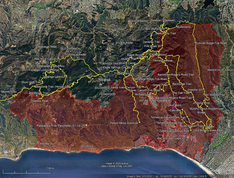
2025 Palisades Fire perimeter and some area trails.

The information in this post may be incorrect or out of date. For official information see the Palisades Fire incident page on the CAL FIRE website. The perimeter is from the Wildland Fire Interagency Geospatial Services (WFIGS) Group and National Interagency Fire Center (NIFC) website. The perimeter shown has a poly_DateCurrent of 1/14/2025 4:30:52 AM UTC.

Here’s an interactive, 3D terrain view of the 2025 Palisades Fire perimeter along with GPS tracks of some of the trails in the area.

Also included is a Copernicus Sentinel-2 overlay a few minutes after the start of the fire. The image data was processed using an Active Fire Detection script from SentinelHub. The image sensing timestamp is January 7, 2025 at 10:36:49 AM PST. Here is a broader view of the Sentinel-2 L1C image processed with the Active Fire Detection script.

The active fire detected coincides with the smoke plume near Skull Rock discussed in this Washington Post article. As the article notes, this is in the area burned by the Lachman Fire on New Year’s Eve. Here is a zoomed-in 3D terrain view of the area near Skull Rock.

The approximate location hypothesized in the Washington Post article of the area where there might have been re-ignition of the New Year’s Eve fire near Skull Rock  is also noted.

The locations of placemarks, trails, and other data are approximate and subject to error.

Related post: 2021 Palisades Fire Perimeter and Some Area Trails

Very Dry Start to the Downtown Los Angeles 2024-2025 Rain Year

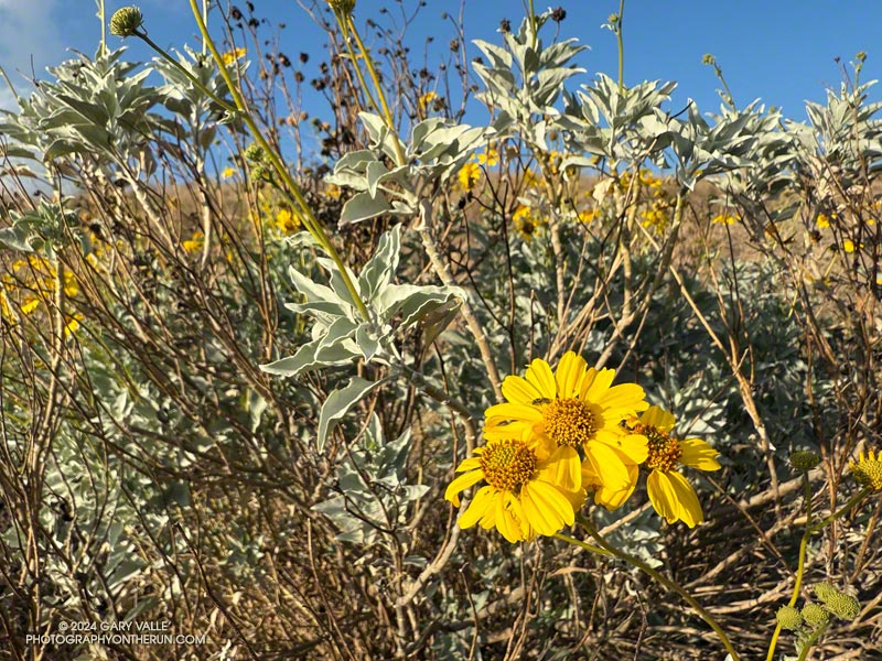
Blooming brittlebush (Encelia farinosa) on the southwest corner of Lasky Mesa at Ahmanson Ranch on December 24, 2024.

The last time Downtown Los Angeles had more than a smattering of rain was mid-April 2024 — more than 250 days ago. To date, the Rain Year beginning July 1, 2024 has been one of the two driest in the 147+ year weather record for Downtown Los Angeles.

Because of the time of year, and lack of rain, not many wildflowers were blooming along Los Angeles area trails at the end of 2024. One exception was this brittlebush (Encelia farinosa) on the southwest corner of Lasky Mesa in Ahmanson Ranch.

If Los Angeles doesn’t see any rain by January 9 — which appears likely — the period July 1, 2024 to January 9, 2025 will be tied with 1962-63 for the driest on record.

Trippet Ranch Loop, Musch and Garapito Trails – February 2024

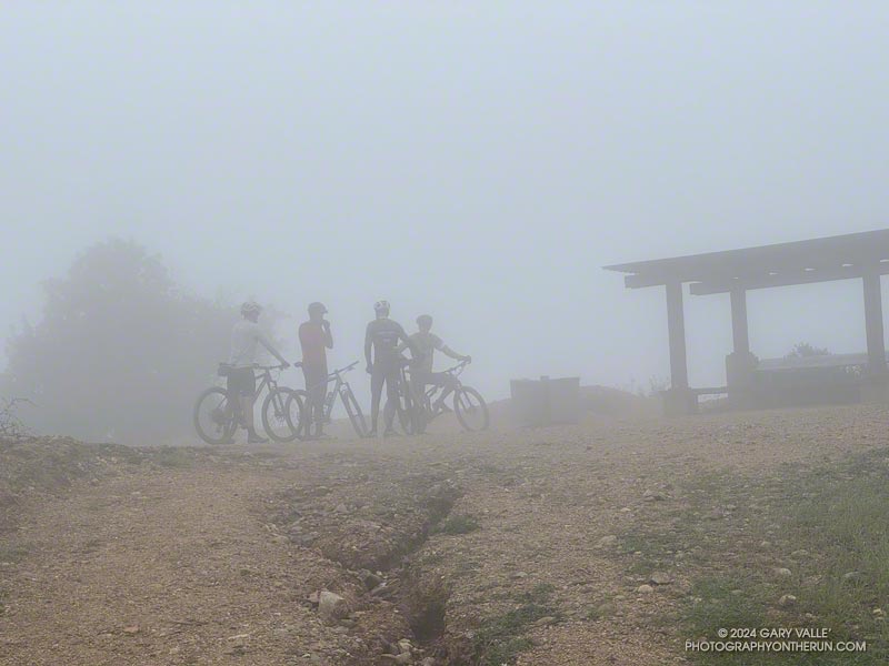
Mountain bikers at the Hub in Topanga State Park
Mountain bikers at the Hub

It’s uncommon to have back-to-back Rain Years with 20+ inches of rain in Los Angeles. During Rain Year 2022-2023, Downtown Los Angeles (USC) recorded 28.4 inches of rain — about two times normal. This rain year Los Angeles has already had about 21 inches of rain, so another big year is in progress.

Curious to see how the trail conditions compare to last year, on February 17th and 25th I ran the Trippet Ranch Loop in Topanga State Park.

The big surprise was that the fire roads on the loop — Fire Road #30, Eagle Springs Fire Road, and a short section of Eagle Rock Fire Road — generally fared better than last year. Fire Road #30 had some damage along it’s shoulder, but I did not see the numerous mudslides along these roads like last year.

Wet and muddy section of the Musch Trail. February 2024. (Thumbnail)
A little mud on the Musch Trail.

The news on the trails was divided. One of the more unusual events occurred where the Garapito Trail crosses the east fork of Garapito Creek. A mudslide from a gully on the northwest side of the creek crossed the creek, and left a pile of debris on the trail. The stream may have been dammed by mud and debris for a short time. Farther up the trail, about a half-mile from Eagle Rock Fire Road, a section of the trail collapsed in a slide.

The Musch Trail was very muddy and wet in the usual places. There were a couple of slides along the trail, but all things considered, the trail was in OK shape. The Bent Arrow Trail remains closed as a result of previous storm damage.

Last year, the bloom of bigpod Ceanothus was well underway in early January. This year the bloom began about a month later but is now happening in a big way. Greenbark Ceanothus is also starting to bloom. Some peonies were blooming on an east-facing slope of the Garapito Trail, and a Fuchsia-flowered gooseberry was in bloom near Fire Road #30.

Here are some photos taken on these two runs.

Some related posts:
Popular Trails in Topanga State Park Damaged by Winter Storms
Wettest 14 Months in Los Angeles in 134 Years
Rainy Season Trail Running on the Backbone Trail

Wettest 14 Months in Los Angeles in 134 Years

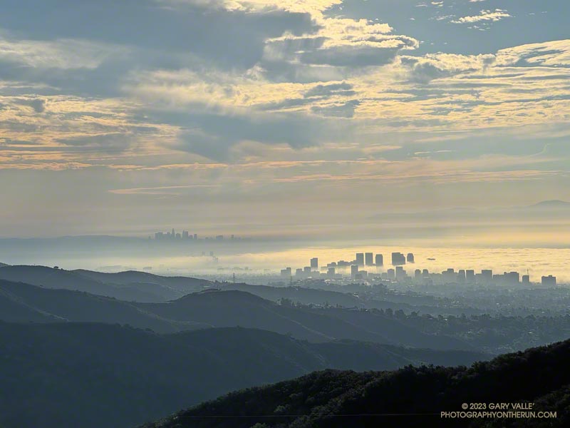
Los Angeles Basin from Temescal Lookout

With over 45 inches of rain reported, the 14 months (424 days) ending February 22, 2024, have been the wettest in Downtown Los Angeles in 134 years.

To put this in perspective, this is more than three times the amount Los Angeles would see in a “normal” year.

The wettest 14 months on record for Los Angeles occurred during late December 1888 to early February 1890, when about 47 inches of rain was recorded.

Ahmanson Blue Oak Succumbs to Climate Change

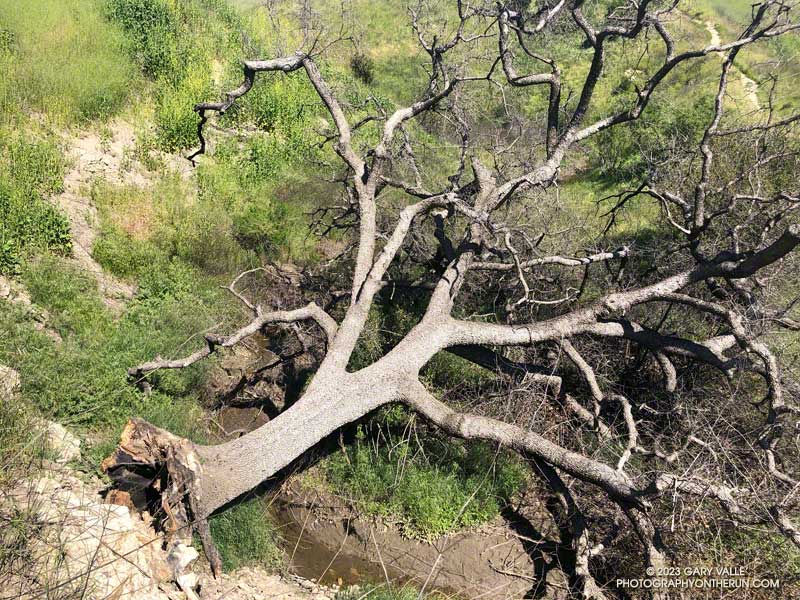
Rare at this latitude, this blue oak at Upper Las Virgenes Canyon Open Space preserve succumbed to drought, fire, and above average temperatures.

When I rounded the corner on the Lasky Mesa Trail, I could hardly believe my eyes. The Ahmanson Blue Oak was gone. Where there had been a sprawling oak, there was nothing.

Crossing an eroded section of trail and walking over to the edge of the old roadbed, I looked down the slope. Much like this valley oak along Rocky Peak Road, the entire Ahmanson blue oak  had fallen from its hillside perch near the bottom of the canyon.

Oaks in the oak-grasslands of Upper Las Virgenes Canyon Open Space Preserve have had a tough time with climate change. The five-year drought from July 2011 to October 2016, increasing temperature, and the 2018 Woolsey Fire have combined to kill a large number of trees.

This blue oak was one of very few found at the southern extent of its range.

Related posts: Ahmanson Blue Oak, Ahmanson Valley Oaks Battling Drought, After the Woolsey Fire: Ahmanson Ranch, Fallen Oak, Valley Oak Savanna

Popular Trails in Topanga State Park Damaged by Winter Storms

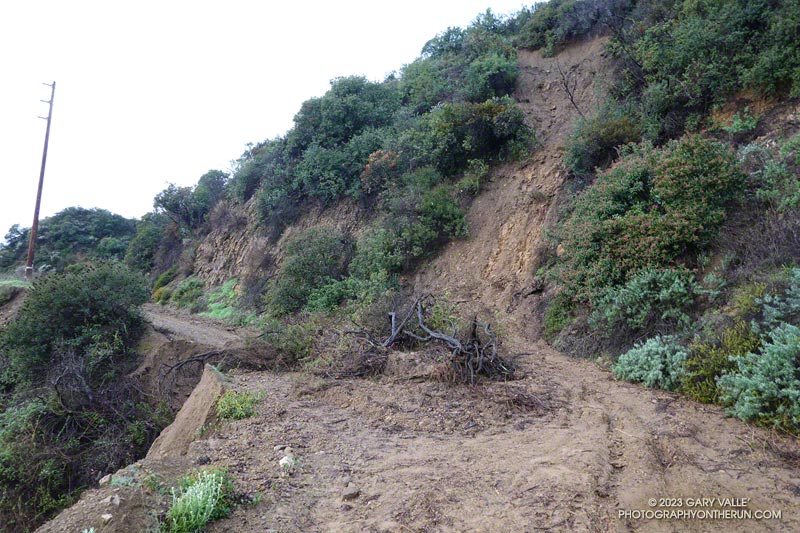
Mudslide on Fire Road #30 below the Hub in Topanga State Park
Mudslide on Fire Road #30 below the Hub

Several popular trails and fire roads in Topanga State Park have been damaged by the cumulative effects of Winter 2022-2023 rainstorms.

Since December 1, 2022, the Topanga Remote Automated Weather Station (RAWS) has recorded nearly 16 inches of rain. The most rainfall occurred January 9-10, when about 5.4 inches was measured.

On Sunday, January 15, I did an exploratory trail run from the Top of Reseda that took me through some popular areas of the Park. This included Fire Road #30, the Hub, Temescal Peak, Temescal Lookout, Temescal Ridge Fire Road, Eagle Springs Fire Road, Eagle Rock Fire Road, the Garapito Trail, and the Bent Arrow Trail.

There were numerous mudslides on the fire roads. The larger slides were on Fire Road #30 below the Hub and Temescal Ridge Fire Road between the Backbone Trail junction and Temescal Lookout. There was also significant roadbed and shoulder erosion in places. At the time, all were passable on foot.

The trails were a different matter. Unfortunately, much of the repair work done on the Bent Arrow Trail following last year’s rain was damaged or destroyed.

The Garapito Trail was blocked in two places on the upper part of the trail. One problem was from a sluff of soil and brush sliding onto the trail. The other was from the collapse of a section of trail. There were additional sluffs, limbs, and washouts on the trail that were passable at the time.

Update February 5, 2023.  The Bent Arrow Trail is closed. Fire Road #30, Eagle Springs Fire Road, and East Topanga Fire Road to Parker Mesa Overlook had all been cleared. The Musch Trail was eroded in spots but OK. Use of the Garapito Trail has moderated its condition. Some brush had been cleared and paths have evolved through the sections of collapsed trail. Extra care is required in some spots.

Here are a few photos taken along the way.

Other trails and fire roads in Topanga State Park likely had similar impacts. I would expect, like last year, sections of the Santa Ynez Trail lower in the canyon to be washed out.

Related post: Trippet Ranch Loop Plus the Santa Ynez Trail