Category Archives: smmc open space

Curious Coyote

Curious coyote at Upper Las Virgenes Canyon Open Space Preserve (Ahmanson Ranch)

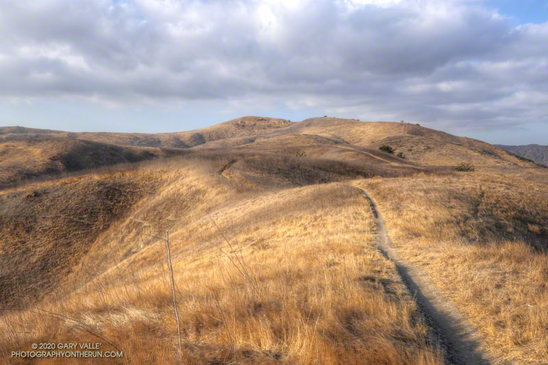
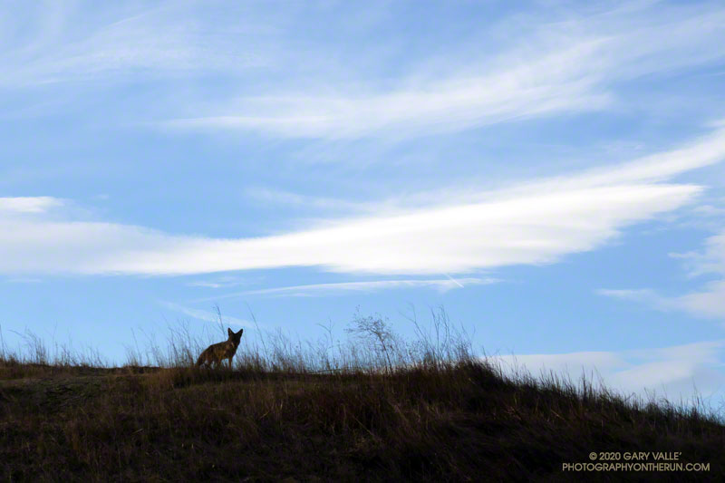
This afternoon I was running down a single-track trail at Upper Las Virgenes Canyon Open Space Preserve (Ahmanson Ranch), when I noticed a coyote on a parallel track across a small ravine. From time to time I would stop and watch the coyote, and from time to time it would pause and watch me. After a few minutes, it went its way, and I went mine.

Earlier in the run I’d been in the same area when a coyote, running at full speed,  came blasting down a single-track trail. It turned into the brush about 30 yards in front of me. I’d seen similar behavior once before when one coyote was chasing another. In this case a hiker followed the coyote down the trail. In my experience, it usually take more than a simple encounter with a hiker to panic a coyote.

Coyote at Upper Las Virgenes Canyon Open Space Preserve (Ahmanson Ranch)
Another curious coyote. Click for a larger image.

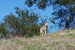
Update February 18, 2021. The coyote pictured on the right was in the same area as the coyote in the title photo. When I first encountered the coyote, it had just crossed the trail and was below me. For some reason it reversed its course and climbed to a viewpoint above me, and watched as I ran up the trail. After a few moments it ran back down hill, retracing its original course across the trail. It was one of the most well-conditioned coyotes I’ve seen out at Upper Las Virgenes Canyon Open Space Preserve (Ahmanson Ranch).

I have had a couple of unusual encounters with coyotes out at Ahmanson. One time, a coyote decided to run with me, as if on a leash.

Some related posts: Coyote Tag, Coyote Tag II, Coyotes Are Curious Creatures

Trail Run and Hike to Peak 1842 at Ahmanson Ranch

Trail toward peak 1842, the highest point of Ahmanson Ranch

The hill marked with an elevation of 1842′ on the USGS 7.5 minute Calabasas quadrangle appears to be the highest point of the portion of the Ahmanson Ranch property that was going to be developed.

I usually start the 2+ mile trail run to the peak by ascending the Hill Climb Trail — a short, steep hill a little west of the kiosk at the Victory Trailhead. A less steep trail can be found a little farther to the west.

Once at the top of this initial 120′ high hill, I try to run — without walking — all the way to the ridgeline just west of the peak. Whether I walk or not, it’s a fun run with excellent views of the area.

From the ridgeline at the top of the single-track trail, there is usually some sort of a use trail to the top of the peak. The location and clarity of the path varies from year to year. The area can be very overgrown. It’s worth taking the time to find and stay on a use trail. Earlier this December, I encountered a rattlesnake while trying to follow an old route through the brush.

Here’s a Cesium interactive, 3D view of my route.

Note: The Ahmanson Ranch project property and Upper Las Virgenes Canyon Open Space were combined to create Upper Las Virgenes Canyon Open Space Preserve.

Ladyface, Sun and Clouds

Ladyface, sun and clouds from Lasky Mesa

The photograph of Ladyface and the setting sun was taken from Lasky Mesa during an afternoon run in Upper Las Virgenes Canyon Open Space Preserve (Ahmanson Ranch).

Related post: Longer Late Afternoon Runs

Winter Sky: Cirrocumulus Clouds

Cirrocumulus clouds from Upper Las Virgenes Canyon Open Space Preserve, also known as Ahmanson Ranch

Cirrocumulus clouds form at high altitude. They are primarily composed of ice crystals but also contain supercooled water droplets.

The photograph of cirrocumulus clouds was taken in Las Virgenes Canyon on a trail run from the Victory Trailhead of Upper Las Virgenes Canyon Open Space Preserve, also known as Ahmanson Ranch.

Some related posts: Pattern Change Ahead, Fallstreak Hole, Rainbow Colors in Cirrus Clouds Over Los Angeles

Acmon Blue Butterfly on Narrow-leaved Milkweed

An Acmon Blue butterfly on narrow-leaved milkweed on Lasky Mesa. August 6, 2020.

An Acmon Blue butterfly on narrow-leaved milkweed on Lasky Mesa.

From a run in Upper Las Virgenes Canyon Open Space Preserve (Ahmanson Ranch) on August 6, 2020.

Some related posts: Painted Lady Butterflies in Upper Las Virgenes Canyon Open Space Preserve, Checkerspot Along the Garapito Trail, Tiger Swallowtail on Snow Plant

Explosive Growth of the Lake Fire

Development of Lake Fire pyrocumulus cloud over 10 minutes
Growth of the Lake Fire in just 10 minutes.

Lake Fire pyrocumulus cloud at about 4:21 p.m.
Lake Fire pyrocumulus cloud at about 4:51 p.m.

The photographs above show the rapid development of the pyrocumulus clouds associated with the Lake Fire, near Lake Hughes. The timestamps are approximate.

According to the Lake Fire incident page, the fire was first reported on August 12th at 3:40 p.m.

The photographs were taken during a run at Sage Ranch Park. This is the location of the Sage Peak1 and Sage Peak2 ALERTWildfire cams.

Related post: Did Lightning Start the 2002 Curve Fire?