Owens Peak from Walker Pass

Three climbers pick their way through the rubble on the southwest ridge of Owens Peak.

A good way to think of this adventure is as an excellent 17 mile trail run on the PCT north from Walker Pass (5217′), combined with a three mile scramble up and down the rocky southwest ridge of Owens Peak (8453′).

Based on the expanse of granite seen from Hwy 395, I had visualized the southwest ridge of Owens Peak as a somewhat vegetated but relatively clean  ridge. Wrong! The ridge is a geologically complex mix of fractured metamorphic, metavolcanic and gabbro rock capping the granite of Owens Peak. In most areas the rocky sections of the ridge are bounded by dense brush and pinyon pine.

We pretty much stuck to the crest of ridge on the way up, continuing up and over the steep outcrop just below the summit. Although it was an interesting section to climb, the outcrop was quite loose, and we dropped below it on the descent.


Mt. Whitney, Mt. Langley, and Olancha Peak from Owens Peak.
Owens Peak is relatively isolated, and the views from the summit are sweeping. To the north we could see Mt. Whitney, Mt. Langley, Olancha Peak, and the windblown crest of the Sierra between Army and New Army Pass.

Not everyone would see the positive aspects of doing a 10 mile route to a peak that could be done in only 3.5 miles — or enjoy the ups and downs, and somewhat tedious route-finding along a brushy and crumbling ridge. It’s an acquired taste. It was good to share the experience with enthusiastic friends who were still smiling as we jogged down the last yards of trail to the car.

Here’s a Google Earth image and a Google Earth KMZ file of a GPS trace of our route. GPS reception was weak at times on the way up and the track has been edited to remove some of the larger errors.

Note: After the Spring snowmelt, it appears there are no natural water sources on the PCT between Walker Pass and Owens Saddle (mile 8.6), or on the ridge.

Related post: PCT North of Walker Pass

Secret Trail to Calabasas Peak

View east from near the summit of Calabasas Peak.

Along with the Chumash Trail to Rocky Peak Rd., the Secret Trail to Calabasas Peak is one of my favorite local short trail runs. The two mile route to the peak is a mix of single track and dirt road that gains about 750′ in elevation.

The trail winds its way through shaded ravines, dense chaparral and sandstone outcrops to Calabasas Peak Motorway. This fire road is followed south about half a mile to a use trail (on the right) that follows a ridge to the summit. It’s also possible to continue higher up the road and access the summit from the south. There is a survey marker (actually two) on the summit.

Here’s a Google Earth image showing the summit area, and a Google Earth KMZ file of a GPS trace of my route.

Calabasas Peak Motorway continues down to Stunt Rd. and connects to the Stunt High Trail and points beyond. Here’s what Calabasas Peak looks like from the Backbone Trail near Saddle Peak.

Related posts: Tapia Bound, A Long Run Kind of Day

Condor Peak Trail Run

Trail runner on the Condor Peak Trail as it nears Condor Peak.

The temp was in the 30’s and it took a couple of minutes for my car’s engine to warm enough to thaw the coating of ice on the windshield. I was headed for a run in the San Gabriel Mountains and was wondering how cold it might be.

In a November in which 29 days had been bone dry, it had rained on the 30th, and temps had cooled dramatically. That was day before yesterday. This morning the sky was still a storm-cleansed blue, and except for a few passing high clouds, promised to stay that way. If the winds were not too brisk, it could be one of those invigoratingly crisp late Autumn days — cold in the shadows, but warm and pleasant in the sun.

About an hour later Miklos and I were working our way up the Condor Peak Trail (13W05), not far from the trailhead on Big Tujunga Canyon Road. At the parking area I had shed some extra layers and was now running in shorts and a light long-sleeve top. In the pack were an ultralight shell, gloves, and a headband.

About a 1/4 mile from the parking area we caught up to some hikers and their dogs. They asked us if we were headed “to the top.” I replied that we were doing Fox Mountain and Condor Peak, and would continue on to the Trail Canyon Trail.

“Do you have a car at the Trail Canyon trailhead?”

“Yep…”

“You know it’s 17 miles, right?”

“Yep…”

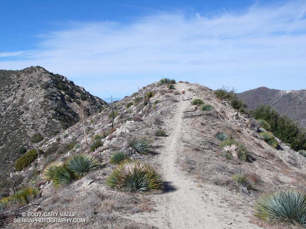
Twenty minutes into the run, we reached the point where the old trail jumps up from Big T and joins the main trail. From here we turned north, away from the highway, and began a long, winding, uphill course that would eventually reach the divide between Fox Mountain (5033′) and Condor Peak (5440’+). This meandering approach resulted in a very runnable section of trail that gains about 2500′ in 5.5 miles — an average 8.6% grade.

As the trail wound in and out of canyons, and from shadowed to sunny slopes, the temperature contrasts were startling. Within a few feet, we would stride from balmy, solar heated granite alcoves into frosty, refrigerated nooks near freezing. We estimated the difference in temperature to be 30-40 degrees.

Gradually we gained elevation, and in about an hour and a half we crested the broad divide at the base of Fox Mountain. From this point a short — but steep — path leads directly to Fox’s summit. 

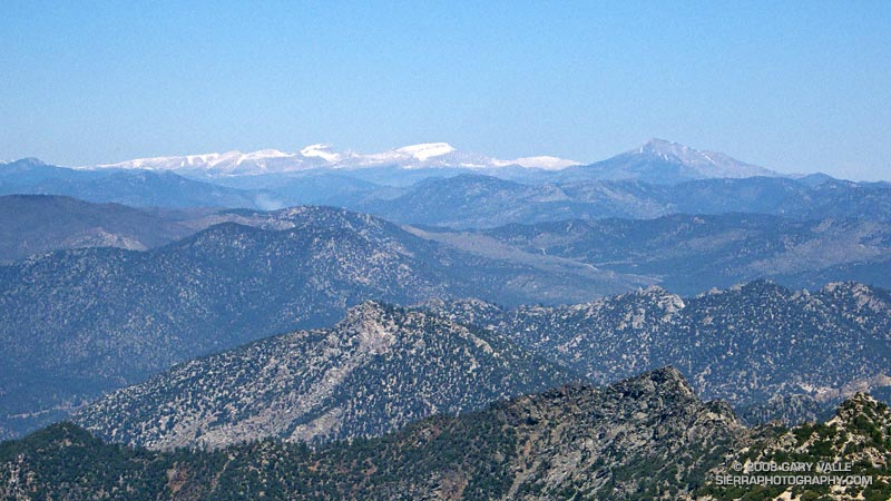
Deep in morning shadow, the east side of the peak was cold! The ground was frozen, and heavy frost covered fallen leaves of chaparral. A few strenuous minutes and we were atop the peak, relishing the warmth of the sun and the panoramic view. Mt. Lukens, Josephine Peak, Strawberry Peak and Mt. Wilson loomed nearby. Further to the east, beyond Mt. Waterman and Twin Peaks, Mt. Baldy glistened white with a new coat of snow. Dressed for running, and damp from the climb, chill breezes hurried us from the summit.

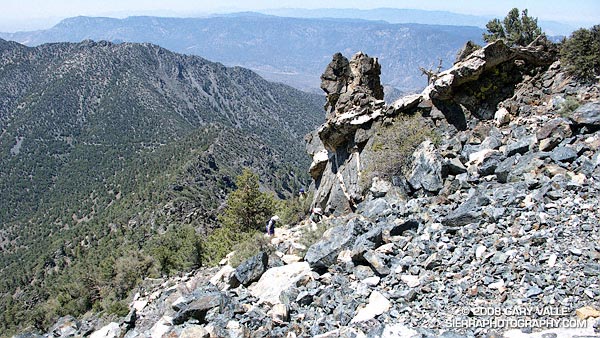
Peak to peak the distance from Fox to Condor is over two miles. That’s what the map says, but on the ground Condor looks deceptively close. Several false summits amplify the deception, and many a hiker has been deceived. Even having viewed the route from Fox and climbed the peak before, I still did not fully appreciate the distance.

The scramble up Condor was a little longer than the hike up Fox. The peak has twin summits at very nearly the same elevation. We were curious which summit would have the register and found it on the more westerly summit. To do both Fox and Condor only added about an hour to our run.

Once down from Condor Peak it took about twenty minutes to hoof it over to the Trail Canyon Trail (13W03) junction. From here the trail drops about 3110 ft. in six miles. The grade of the trail is steeper than the Condor Peak trail, and a little more rocky and technical. Where the Condor Peak trail seeks the high lines, the Trail Canyon trail follows a creek and plunges into a deep riparian canyon.

Back at the car we marveled at what an enjoyable run it had been. The perfect weather and nearly ideal grade of the trails seemed to make the run almost effortless. It isn’t always that way.

Here’s a Google Earth image and Google Earth KMZ file of a GPS trace of the route.

Note: Although the Trail Canyon drainage is relatively small, it appears to have generated some sizable flash floods and debris flows. The canyon forms a huge southwest facing “rain catcher.” During Winter storms, the canyon wrings water from moisture laden wind as it is funneled into and up its slopes.

Olancha Peak Sierra Panorama

Part of the Panorama from Olancha Peak.

Part of the Panorama from Olancha Peak

Olancha Peak (12,123 ft.) is the prominent, pyramidal peak seen on the Sierra crest from Hwy 395, south of Olancha. Its rocky summit is above tree line, and in some years snow can persist in the east-facing summit gullies and other sun-protected areas into late June, or early July.

There are better choices for a run in the Sierra, but early in the summer when the passes on other routes are blocked by snow, Olancha may be passable. Views from the summit of Olancha Peak are expansive, and the running on the PCT was enjoyable. Round trip, the distance is an arduous 20 miles, with over 6300 ft. of elevation gain and loss.

The trail starts at Sage Flat, at a relatively low elevation of 5800 ft. As a result, in warm weather it can be hot and dusty. In addition, the trail segment up to Olancha Pass (9200 ft.) can have a lot of pack train traffic. To lessen the chance of encountering horses or mules on the trail, I opted to follow a very steep and rough “cow driveway” that shortcuts 1.3 miles of the trail up to Olancha Pass. It’s hard to imagine driving cattle up this swath, and judging from the cow femur I saw sticking up from the rubble, the cattle don’t find it so easy either.

Beyond Olancha Pass, the aesthetics improve, and a spur trail is followed northwest along Summit Meadow to a junction with the Pacific Crest Trail. The PCT eventually leads to the west slopes of Olancha Peak, and from here the summit is a short second class scramble. Here’s a Google Earth image and Google Earth KMZ file of a GPS trace of my route.

This summit panorama is from a run on June 26, 2005. The view shows the headwaters of the N.F. and S.F. Kern River, and the high peaks of the Southern Sierra. From south (left) to north (right) are the Little Kern, the N.F. Kern near Hole in the Ground, Kern Peak, the Great Western Divide, the Kaweah Group, Junction Meadow, Mt. Whitney, and Mt. Langley.

Mountain Lion Tracks in Upper Las Virgenes Canyon

Mountain lion tracks on the fire road in upper Las Virgenes Canyon, January 28, 2025.

While doing a run from the Victory Trailhead of Upper Las Virgenes Canyon Open Space Preserve (Ahmanson Ranch) yesterday, I came across the tracks of mountain lion headed (north) up the fire road in Las Virgenes Canyon.

The tracks were on the smaller side for a mountain lion, and probably those of a female or adolescent.

Some related posts:
It’s Raining Mountain Lion Tracks!
Mountain Lion Tracks on Rocky Peak Road
Mountain Lion Saga

Brent’s Mountain, Malibu Creek State Park

Brent's Mountain, Malibu Creek State Park. Photography by Gary Valle'

Brent’s Mountain from Mesa Peak Mtwy fire road in Malibu Creek State Park.

The peak and several other locations in the area appear to be named after Edwin James Brent, a furniture store owner in Los Angeles.

“Brents Mountain” is noted on the U.S.G.S. 1929 Solstice Canyon topographic map. The rocky peak towered above Brent’s Mountain Crags resort, which was acquired in 1939 by the Salvation Army.

Adventurers driving to the remote resort likely would have stopped at the Shell gas station at Brent’s Junction — the intersection of Ventura Blvd. (Hwy 101) and Las Virgenes Road.

The photograph of Brent’s Mountain was taken on a recent run of a variation of the Bulldog Loop.

Some related posts:
Clearing Clouds, Santa Monica Mountains
Turning California Sycamore Along Malibu Creek
Reagan Ranch at Sunrise