Category Archives: photography

The Color of Rain

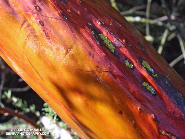
Glistening in the morning sun, the wet trunk of a manzanita glows in iridescent shades of orange and red, pink and purple.

Glistening in the morning sun, the wet trunk of a manzanita glows in iridescent shades of orange and red, pink and purple. Decorated with raindrops, the chaparral, and all within, breathe a deep sigh of relief. It has rained!

Prior to Saturday night’s storm Los Angeles had recorded only 0.5 inch of rain in the last six months. Even by Southern California’s arid standards, this is a meager amount.

Usually when there’s an El Niño, wet Winter weather can be expected to develop in Southern California. But this year’s El Niño has been a little quirky, developing later than usual, and becoming stronger than expected. So far this Autumn, the weather here has been somewhat quirky as well, with record setting high temperatures and below average rainfall. An El Niño, even a strong one, does not guarantee wet weather in our area. Whether or not the usual El Niño impacts eventually develop, we’ll just have to see.

Another system is expected to produce some rain in Southern California this weekend, but in the last couple of days the computer weather models have been backing off the rainfall amounts. This morning’s computer-based precipitation forecasts are nearly dry. Given the difficulty the models have had with this system, and the long fetch of moisture over the Pacific, maybe the forecast will change. For additional info about the El Niño and Southern California weather, check out my Southern California Weathernotes web site.

The manzanita photograph is from the Reseda to Trippet Ranch run described in my previous post, Musch Trail Mule Deer.

Musch Trail Mule Deer

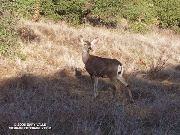
Mule deer along the Musch Trail near Trippet Ranch in Topanga State Park

About ten feet in front of me, there was a flash of brown as a large animal leaped across the trail. In the balloon of time that accompanies a surge of adrenalin, I thought of the possibilities. The last time an animal startled me, I was running on a dirt road through ten foot tall chaparral in the Simi Hills. In that case a large bob cat had bolted from the brush.

Lingering in my mind was a trail runner’s recent encounter with a mountain lion while running at Whiting Ranch in Orange County. The last place I had seen mountain lion tracks was on a muddy nature trail, not far from where I was now. That was more than a year ago. It had rained overnight, but so far I had only seen tracks of coyote, dogs and deer.

Today, I was on the Musch Trail, doing one of my favorite cool weather runs — an approximately 12.2 mile, fire roads out, trails back course from the end of Reseda Blvd. to Trippet Ranch, in Topanga State Park.

As time warped back to normal, I saw the animal wasn’t a bob cat or mountain lion, it was a mule deer. A doe had stopped just a few feet from the trail. That was unusual. Also, it was strange that her full attention wasn’t on me. Instead, she seemed concerned about something behind her, uphill from the trail. I stood quietly and watched.

She appeared to be evaluating the situation, and after about 15 seconds seemed to calm. Still alert, another 15 seconds passed, and following some unseen cue, a six or seven month old fawn was suddenly at her side.

Now her big ears, and more of her attention, were focused on me. With the fawn at her side, she obviously didn’t like being out in the open. She scented the ground, checked her fawn, and then looked back up the hill. I couldn’t see any more deer from my position, but they could easily be hidden in the surrounding cover. Almost a minute and a half after the encounter began, the doe and fawn moved into the brush.

Slowly moving a few feet along the trail, I glanced up the hill and discovered two more members of the group, waiting for me to pass. I continued walking down the trail, and after few yards, picked up the pace, and resumed my run.

Here’s a Google Earth image and Google Earth KMZ file of a GPS trace of the route.

Related posts: Christmas Berry, Mountain Lion Saga, Ferns Along the Garapito Trail.

Chumash-Hummingbird Loop

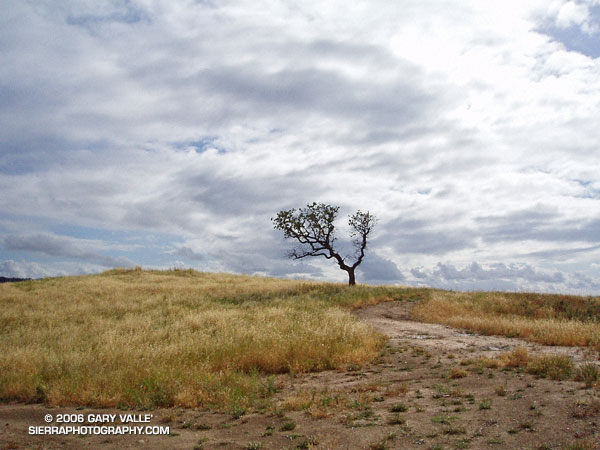
Oak, grass, and clouds in Simi Valley, California.

The Chumash and Hummingbird trails are popular trails in the eastern Simi Valley, north of the 118 Freeway. These trails ascend the steep western flank of the Santa Susana Mountains to Rocky Peak fireroad. A scenic loop can be created using these trails and a connection between the Chumash and Hummingbird trailheads down in the valley. There are a few ways to do this, and the loop has proved popular.

The Chumash trailhead is on Flanagan Dr., off of Yosemite, and the Hummingbird trailhead is on Kuehner Dr. just north of the 118 Frwy. Currently, no official trail connects these trailheads. To connect them via city streets (Yosemite, E. Los Angeles Ave., Kuehner) is a long detour on pavement and doesn’t make sense from a trail-running or hiking point of view.

For many years a more direct, unofficial route has been used to connect the two trailheads. Most of the route is on dirt roads through undeveloped property. Using this route the length of the Chumash-Hummingbird loop works out to about 9.2 miles with about 1700′ of elevation gain. It’s an excellent hike, run or ride with great scenery and views.

For a number of years access to the Hummingbird Trail from Kuehner Dr. has been across property that is now being developed. A chain link fence has been in place along Kuehner for some time. Apparently, at the north end of this chain link fence there is a conservation easement that allows access to the Hummingbird Trail  via a corridor adjacent to the (private) Hummingbird Ranch property. It was necessary to use this access easement when I ran this loop last weekend.

The property on the west side of Kuehner is also being developed. As I understand it, Mt. Sinai Dr. will eventually connect to Kuehner and a small parking lot will be built for trail users. Hopefully, some provision will also be made to officially connect the Chumash and Hummingbird trailheads and preserve this scenic loop.

The photograph of the oak is from a run of the loop on April 28, 2005.

Update 12/26/06 – Mike Kuhn, the director of the Rancho Simi Trailblazers, sent me the following information regarding the Hummingbird trail easement:

“At the top of Kuehner Drive is a cul-de-sac at the gate to the Hummingbird’s Nest Ranch. The white plastic fence marks the boundary of the ranch. There is a corridor of land owned by the park district along the white plastic fence down to the creek and hence to the usual crossing of the creek.”

He also said that a trail connection between Chumash and Hummingbird is in the planning stages, and encourages all trail users to be patient while the construction at Kuehner is underway.

Related post: Lower Stagecoach – Hummingbird Loop

Christmas Berry on the Garapito Loop

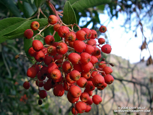
Photo of the berries of toyon,  Christmas berry (Heteromeles arbutifolia)

A photo of the berries of Toyon (Heteromeles arbutifolia) taken on the Garapito Loop trail run on Thanksgiving Day. Also called Christmas berry, the plant is protected by a California law.

The Garapito Loop is a pleasant 7.5 mile figure eight course that starts at the south end of Reseda Blvd. at Marvin Braude Mulholland Gateway Park, goes up to near Eagle Rock via Fire Road #30 and Eagle Rock Fire Road, and then returns via the Garapito and Bent Arrow Trails. Here’s a Google Earth image of a GPS trace of the route and a 3D, interactive view of a slightly longer variation of the loop that visits Eagle Rock.

Also see: Ferns Along the Garapito Trail

Topatopa Bluff

Fire Break on West Ridge of Topatopa Bluff

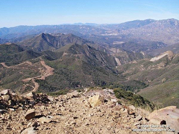
Fire Break on West Ridge of Topatopa Bluff

Crossing Sisar Creek, I debated running through the cool water. I had been running non-stop since White Ledge Camp, and had been pushing the downhill. It was a warm day and my feet were hot and my socks damp and gritty — it would feel great to dunk them. But gravity and the nearness of the trailhead pulled me across the gurgling creek and I continued to run.

Looking down Sisar Road I could see a couple of riders on horseback, accompanied by a hiker. As I approached them, I slowed and then walked. They asked me how far I had gone, and I replied, “Topatopa.” The hiker responded that she hadn’t been to the summit since the Day Fire threatened the area, and asked if it was open. I told her that I thought so. I had checked the updated closure map on the Los Padres National Forest web site, and the best I could tell, Topatopa Bluff (peak 6367) was just outside of the closed area.

Earlier, I had run up this road to trail 21W08, the Red Reef Trail, and then followed the recently groomed trail up past White Ledge, to Hines Peak Road.

On the way up the road, the view of the bluff had been deceptive. The highpoint wasn’t atop the the most obvious of the layered cliffs of 50 million year old Matilija sandstone, but was an indistinct summit on the left side of the formation. This Google Earth image gives a good overview of the location of the peak.

Above White Ledge Camp there had been great views of the Ojai Valley, the coast from Pt. Mugu to Ventura, and the Channel Islands. At the point where the Red Reef Trail met Hines Peak Road a large area had been cleared of brush, but had not burned. After running a few tenths of mile east on the road, I had seen hints of a trail switchbacking up through the thick brush on the west ridge of Topatopa Bluff, and left the road.

A fire break had been constructed along the crest of this unburned ridge, more or less on top of the right margin of the trail. Judging from the berms along the break, in addition to hand crews, a dozer had been used to the cut the swath. Given the steepness of the terrain, this must have been class V dozer-driving! Using the remaining segments of the trail as much as possible, I had worked my way up the final 1000′ of elevation and plodded onto the unburned summit.

It was sobering to stand at the edge of the fire area and see the full extent of the 162,702 acre fire. The day was clear, and Mt. Baden-Powell could be seen in the San Gabriel Mountains, some 75 miles to the east. To the east-northeast, past Hines Peak and in the direction of I-5 and Pyramid Lake, the earth had been burned and blackened, and nearly all vegetation appeared to have been consumed.

According to news reports, the month-long fire started on Labor Day near Pyramid Lake, more than 20 miles distant, and was not contained until October 2. Approximately 4600 firefighters from 39 states fought the fire.

Substantial portions of the Sespe and Piru Creek drainages were burned in the fire. Even without considering the effects of the fire, which generally increases runoff, these tributaries of the Santa Clara River have the potential to produce high flows. On January 10, 2005, the USGS gage 11113000 SESPE C NR FILLMORE recorded a peak flow of 85,300 cfs, and the USGS gage U11109600 PIRU CREEK ABOVE LAKE PIRU CA a peak of 40,000 cfs. Smaller creeks that extend into the burn area could also produce higher than normal flows.

In part due to a developing El Niño, an increased probability of higher than average precipitation is projected for Southern California. While an above average amount of precipitation is by no means guaranteed, the wet outlook is no doubt one of many issues being considered by the Day Fire Burned Area Emergency Response team.

Here’s a Google Earth image and a Google Earth KMZ file of a GPS trace of my route.