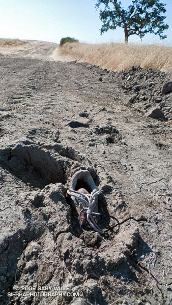
Exactly as I found it on my run at Ahmanson today. Looked like a fairly new running shoe.

Exactly as I found it on my run at Ahmanson today. Looked like a fairly new running shoe.
Last year on this date, Southern California was in the middle of a heatwave. On June 20, 2008, Los Angeles Pierce College in Woodland Hills reached a record-setting high of 111°F, and on June 21 the temp reached 108°F!
Not so this June! So far this month, Downtown Los Angeles has not had a day when the average temperature was above normal. And it’s not only the low elevation stations that have been cool. Several times this month the overnight low at the Big Pines RAWS, near Wrightwood in the San Gabriel Mountains, has dropped into the thirties, and daytime temps have averaged more than 10 degrees below normal.
This translates to great running weather in Southern California, and near perfect weather for trail running in the San Gabriel Mountains. Today, did the Three Points – Buckhorn loop, along with a short detour up to the summit of Waterman Mountain. The route worked out to about 23 miles with a reality-checked elevation gain/loss of about 3800′. Here’s a Cesium browser View of a GPS trace of the run.
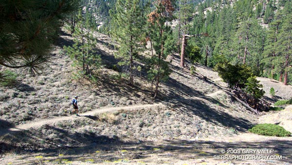
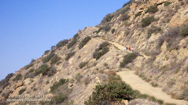
The title photo is of Dave Burke, cruising down a nice section of the PCT between Cloudburst Summit and Cooper Canyon.
Related post: Three Points Loop Plus Mt. Waterman
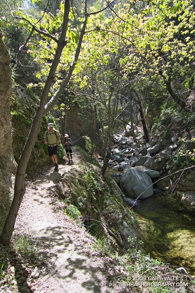
Bear Canyon
The creek burbled a gentle song of Spring, and downstream a Canyon Wren replied. Standing near the bottom of the narrow gorge, my eyes followed the soaring trunks of a grove of alders to their canopy of new leaves — backlit and bright green in the sun.
Bright green in the sun… In my run-altered state it was one of those aha! moments. The alders are just tall enough to reach from the shadows of the canyon into the sun – and – without the water in the stream that cut the canyon, the alders could not grow to the necessary height. The pieces fit — or was it the endorphins talking?
We were in Bear Canyon, west of Mt. Wilson, about 10 miles and 15 stream crossings into a 20 mile loop. An idyllic hike along Arroyo Seco a couple of weeks before had reminded me of this wonderfully wild trail.
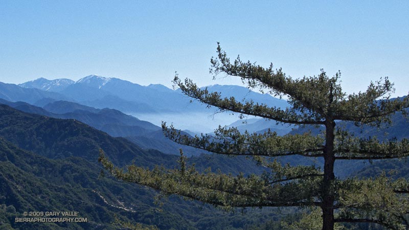
Our adventure had started at Red Box, on Angeles Crest Highway. Working east down the Gabrielino Trail to the West Fork San Gabriel River, snow could be seen glistening in the morning sun on Mt. Baldy’s summit slopes. There was no snow on our trail, just warm sun, buzzing bees and blooming manzanita. Continuing down the forested river canyon, we followed the Gabrielino Trail to Valley Forge, and then ascended the winding Valley Forge Trail to Eaton Saddle on the Mt. Wilson Road.
At the Mt. Lowe fire road gate at Eaton Saddle we were greeted by yellow warning tape and an “Unsafe for Travel” sign. What had happened? Did Mueller Tunnel collapse or something? Not inclined to turn back, we continued along the road, promising ourselves that we wouldn’t do anything reckless.
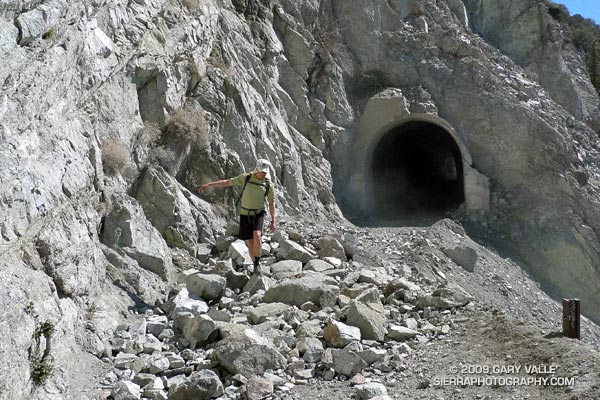
Other than the tracks of heavy equipment, nothing seemed out of the ordinary as we approached the tunnel. I had forgotten that the tunnel is curved, and for a moment was concerned when I couldn’t see the exit. But a couple of strides later the arched exit burst into view. The danger was an old one — an ongoing rock slide just beyond the western exit of the tunnel. There must have been a big slide recently. At the moment it was passable, and we figured as long as we didn’t stop under the slide, we’d probably be OK.
From Markham Saddle we followed the Mt. Lowe fire road out Mt Lowe’s elongated west ridge to a single track trail that leads down to Tom Sloan Saddle. From here, the Bear Canyon Trail descends into Bear Canyon following the route of the old Tom Sloan Trail.
Down in the canyon, I was glad to see that the neo-orange plastic tape that had marked the trail in 2007 was now tattered and faded, and not easily seen. Part of the enjoyment of a remote trail is its wildness. The trail descends the canyon — it has nowhere else to go. When progress is blocked on one side of the stream, it crosses to the other side. Plastic tape isn’t needed to show the way.
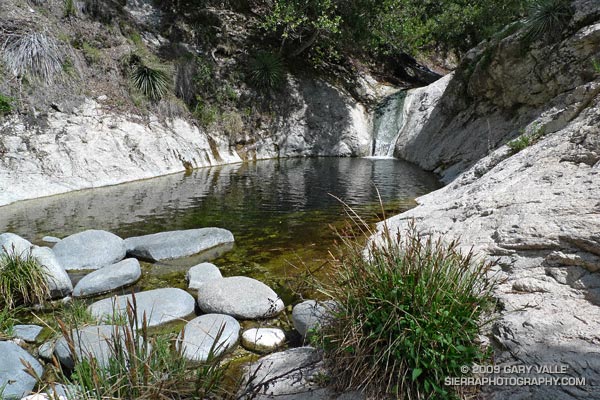
After many such stream crossings, we eventually worked our way down to the confluence of Bear Creek and Arroyo Seco. Along this reach there is a fantastic series of falls, pools and cascades. Gary Gunder and I were blown away by these drops when we kayaked Arroyo Seco down to JPL in 1998.
Following the Bear Creek trail upstream, we were careful not to miss the turn where the trail climbs steeply to the Gabrielino Trail and traverses above Switzer Falls. At Switzers Picnic area we parted ways — Miklos and Krisztina headed back to their car at Clear Creek, and I continued up Arroyo Seco to Red Box. It was a incredibly scenic and enjoyable trail run.
Here’s a Google Earth image and live Cesium ion view of a GPS trace of the Red Box – Bear Canyon – Switzers Loop. According to SportTracks the length of the loop was 19.5 miles with an elevation gain/loss of around 4000 ft.
Related posts: Falls Leaves on Bear Creek, Strawberry – Bear Canyon Loop
Steep climb on the Bandit 30K and 14K Courses.
Low clouds cling to the slopes of Rocky Peak, and a cool downslope breeze stirs through the runners gathered at the start line in Corriganville Park. Three… A race organizer holding a “turn on your Garmin” sign is counting us down. Two… Runners anxious to get on the course collectively take a deep breath. One… Go! The first steep climb is just minutes away…
You never know what you’re going to get in the first edition of a race, but in this case the Bandit 30K/14K organizers appeared to have considered every detail. Check-in went smoothly, the race started precisely at 8:00 a.m., the course was challenging and well-marked, aid & water was where it was needed, volunteers were great, and the finish line had an assortment of tasty treats!
Overall, elite mountain runner Jon Clark edged Kevin Gillotti and Jason Perez, winning the 30K in 2:22:29 — averaging 8 minute miles over the demanding course. Among the women, Lisa Fink placed first, finishing in a time of 3:08:28. In the 14K, women took two out of the top three places, finishing first and third. Jen Todd was first in 1:15:22, followed by Karl Bowers and Meredith Davidson. Results and photos are available on the Bandit 30K/14K web site.
Many thanks to the Bandit Race Committee — Randy & Sarita Shoemaker, Larry Lee, and Todd Baker — and all the volunteers and sponsors for a great race! Also, thanks to Tommi Diaz for her photos of the 30K.
Here’s a Google Earth image, Google Earth KMZ file, and Cesium browser view of my GPS trace of the course.
Update 12/09/10. The date of the 2011 Bandit 15K/30K is Sunday, February 20th. A 50K distance has been added!
The photo of runners on Rocky Peak Road is from a run in November 2007.
Some related posts: Bandit 30K Course Preview, Las Llajas Hill 2484, Running Rocky Peak Road, Chumash Trail Rocks & Snow
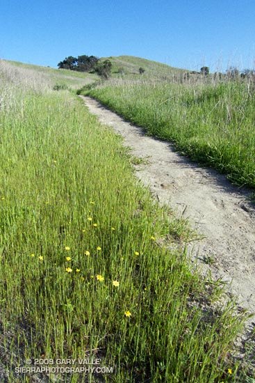
There are still a few rogue mud puddles out at Ahmanson ranch, but the Goldfields are blooming, the meadowlarks singing, and it feels like Spring!
Last week it looked like our rain season might not be over. Now I’m beginning to wonder. This week the GFS and ECMWF forecasts have been much drier in Southern California, with most of the activity focused on the Pacific Northwest. No significant rain is forecast here over the next week, and both the 6-10 and 8-14 day forecasts project below average precipitation in Southern California.
If these medium range forecasts are on the mark, March rainfall for Downtown Los Angeles (USC) will fall well below the 3.14 inch norm. Normal April rainfall is 0.83 inches, and May only 0.31 inches. Beyond March it becomes increasingly unlikely that a big rain event will significantly boost our rainfall total.
Since November 1, Downtown Los Angeles has recorded 8.80 inches of precipitation. This is about what would be expected during a La Nina, and within the range indicated in the composite precipitation map included in the post Southern California 2008-2009 Winter Precipitation Outlook, back in October.
In his March 6 post, Ed Berry suggested the possibility of “more energetic progressive troughs” in the western U.S in the week 2-3 timeframe. That wouldn’t necessarily result in rain in Southern California, but might improve our chances. Numerical weather model performance generally suffers during seasonal transitions, so maybe there are still some surprises lurking in the Pacific. We’ll see!
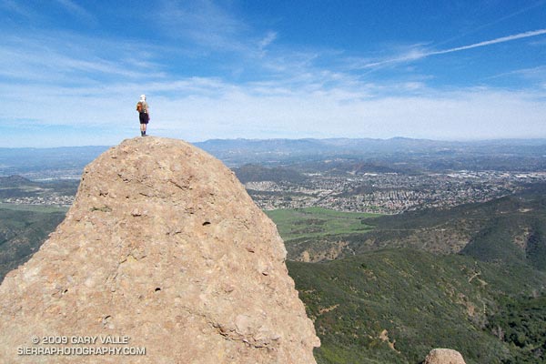
A view of the Conejo Valley from the crags west of the Danielson cabin site. The grassland area in the valley is Rancho Sierra Vista/Satwiwa in Newbury Park, California.
From Sunday’s adventure hike and run to Sandstone Peak in the Santa Monica Mountains.
Related post: Satwiwa Loop Trail