Category Archives: running|adventures

The Best Kind of Training

Crags below the Backbone Trail

The great view confirmed it — we had run uphill. The new section of the Backbone Trail was so well-graded that the 850 feet of elevation gain from the trailhead at Encinal Canyon Rd. seemed almost effortless. For the next 14 miles, we would run through one of the most scenic areas of the Santa Monica Mountains; a rough and rugged highland with a character that might put it halfway around the world, rather than 35 miles from downtown Los Angeles.


Mariposas
On this May Day morning, the canyons were cool, the sun warm, and the skies clear. From the craggy heights views extended from Catalina to the Channel Islands; and from Topa Topa to the San Gabriel Mountains. Winter rains had produced a profusion of wildflowers, accenting the trails with the whites, blues, yellows and reds of Spring.

It was an extraordinary day in which mile after mile of trail would pass underfoot with surprising ease. It was the best kind of training — a run in which the training was an afterthought, and the focus was on the experience, rather than the logbook.

Here’s an interactive Cesium ion view of the 23 mile route from Encinal Canyon Rd. to PCH at Sycamore Canyon. The elevation gain on the run was about 2500 ft., and elevation loss about 3800 ft. Continuing to the Ray Miller trailhead by way of the Wood Vista, Overlook and Ray Miller trails would add about 3 miles and another 1000 ft. of gain. Another option would be to run through Serrano Valley to Sycamore Canyon. The Fireline Trail is a short distance down canyon from the Serrano Valley Trail, and could also be used to link to the Overlook and Ray Miller trails.

And here’s a photo of the Yerba Buena segment of the Backbone Trail when it was under construction in 2003.

Related post: Boney Mountain Crags

Conejo Valley Sun and Boney Mountain Clouds

Conejo Valley from the north side of Boney Mountain.

Pushed up and over Boney Mountain’s two thousand foot western escarpment, Pacific winds condense into thick cloud along its jagged crest. At times breaking free of the mountain’s grasp, patches of cloud drift eastward, creating a patchwork of sun and shadow on the steep slopes, and in the valley below.

In the distance, the Ventura Mountains gleam with a mix of snow and cloud, and below the fields of Satwiwa stand out vibrant and green. At my feet hundreds of purple shooting stars dance in the wind; and nearby yesterday’s rain seeps and trickles from moss to lichen on the scraggy volcanic rock.

It is a remarkable morning, and an exceptional one to be doing the Boney Mountain north side loop. Here’s a short video of some of the views along the way.

Blue Skies and Sunshine for the 2010 Twin Peaks 50K & 50M Trail Runs

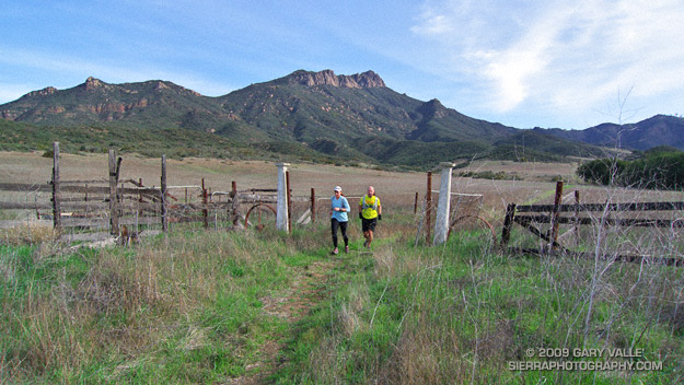
It had been a long time since I was on the summit of Santiago Peak (aka Saddleback). The last time was in 1975, when I flew from the peak on a Sunbird “Butterfly” hang glider. That day had been spectacular, and this was turning out to be a spectacular day as well.

In the throes of an El Niño Winter, Southern California had been pummeled by a series of Pacific storms. With all the rain and snow it seemed unlikely that the Twin Peaks 50/50 would be run as planned. But the key access roads didn’t wash out, most of the snow melted, and blue skies and great weather greeted runners race day morning.


Twin Peaks 50K Elevation Profile
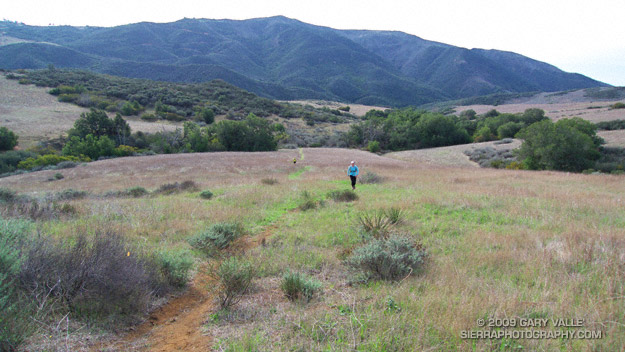
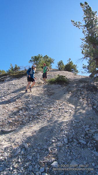
The race started at the bottom of Indian Truck Trail, off the I-15 near Corona. It was warm enough that in our 8:00 wave of 50K runners, only a few people wore sleeves and extra clothing. As we worked up the first switchbacks into the sun, those were quickly shed. The enthusiasm of the other runners was contagious, and this helped with the challenges of the initial 7 mile, 2600′ climb to the Indian Truck Trail aid station.

At that first aid station I grabbed a GU gel, and then headed east on the Main Divide Road toward West Horsethief. For some reason I had it in my head that I might get to run on the flat here for a few minutes. The only way that was going to happen is if I ran around the aid station table. On this course you’re either going up or you’re going down, and here the arrow still pointed up.

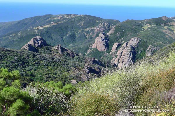
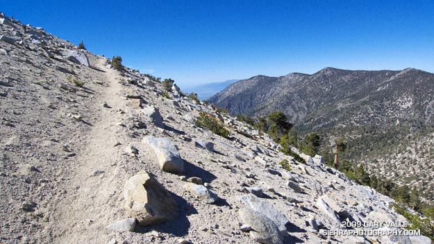
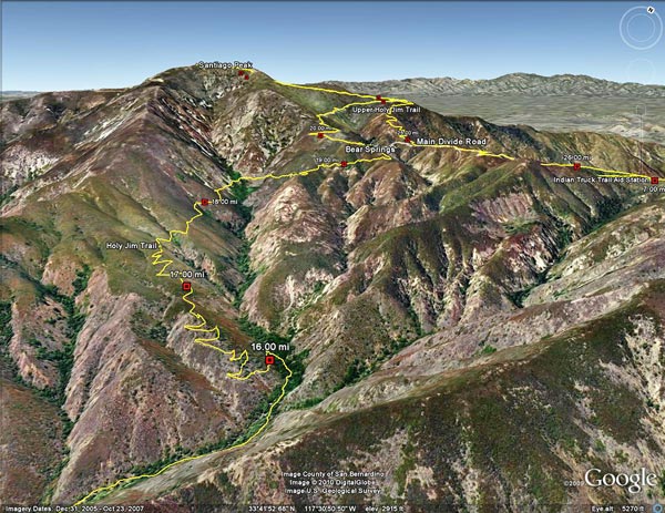
The views along the Main Divide were fantastic. The high peaks of Southern California — Mt. Baldy (10,064′), San Jacinto Peak (10,834′) and San Gorgonio Mountain (11,499′) — glistened in the morning sun, their new snow impossibly white. Down in the valley, an ant-like stream of vehicles moved along the Corona freeway, and our parked cars glittered like a string of tiny beads along Santiago Road. To my right, steep, chaparral covered slopes plunged into the depths of Trabuco and Holy Jim canyons. Somewhere down there was the Holy Jim aid station, and it looked like a long way down.

Billy and Lori working the West Horsethief aid station.
At the West Horsethief Trail aid station (10.2 mi), Billy and Lori greeted me with big smiles and asked if there was anything I needed. I had just been asking myself that same question, wondering if I had enough water to make it to Holy Jim. I guessed that I did, thanked them for being there, and turned down the single track trail.

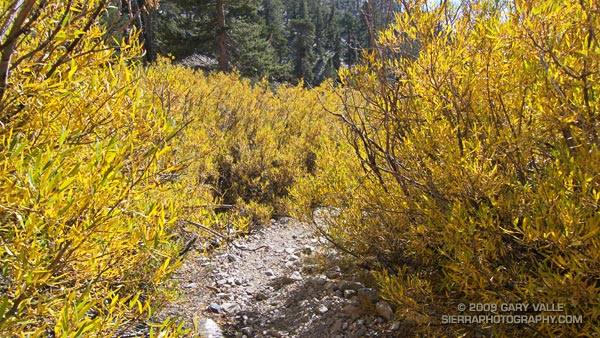
Varied and technical, the West Horsethief and Trabuco trails were my favorite part of the course. While some sections were rocky, or V-rutted from recent rains, long stretches of of the trail were smooth and fast. Once down in the canyon, the creek crossings on the Trabuco Trail were great fun. With the warm weather, wet socks and squishing shoes were no big deal. The lush green growth and the burbling stream eased the long run down the canyon, and at about the 3 hour mark, I reached the Holy Jim aid station (14.5 mi).

This aid station is on the opposite side of the mountain from the start. You’ve done a lot of work to get there, and you’re going to do a lot more to get back. From here it is about 8 miles and a 3900′ gain to the summit of Santiago Peak. It took a while to work up past the cabins in Holy Jim Canyon to the start of the Holy Jim Trail. I knew I was on-route, but I hadn’t run any of these trails, and worried I might accidentally run up somebody’s long driveway.

As I climbed out on the first switchbacks above the creek, Hiroki Ishikawa, the eventual winner of the 50 mile race, rounded a switchback. Elite athletes stand out in any sport — there is a an efficiency and fluidity of movement that is unmistakable. Hiroki was quicksilver fast, and seemed to flow effortlessly down the trail.

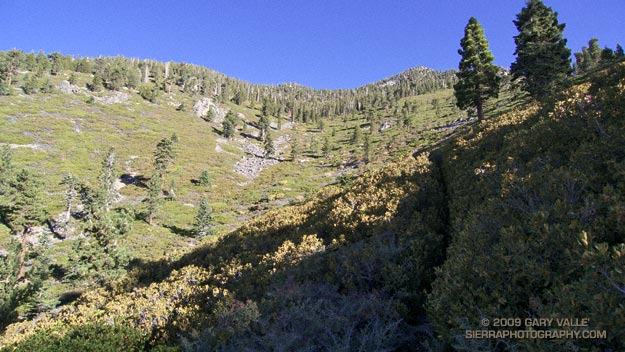
In contrast, I felt a little like mud trying to flow uphill. Fortunately, long stretches of the trail were runnable, and ever so slowly I rose above Holy Jim Canyon. Gradually, the peak tops and rigelines that had been towering above me fell away. About 4.5 hours into the race, I reached the top of the Holy Jim Trail at Bear Springs, and turned left onto the Main Divide road.

The surprising thing about this shady nook is that when you reach this point, you’ve only done a little more than half (56%) of the gain from Holy Jim to Santiago Peak. But hey, I was happy with that, and it felt good to be in the pines and plodding up toward the peak.

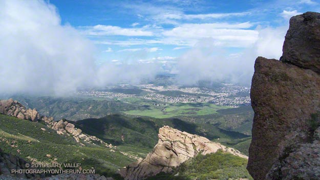
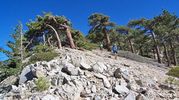
It took about 30 minutes to reach the big switchback at the Upper Holy Jim checkpoint (21.1 mi). From here the summit towers looked tantalizing close. I was happy to keep pace with the “runner in blue” about a hundred yards ahead.  As we neared the top of the peak, sun turned to shade, and the road became covered with snow. It was a cool way to finish a warm climb, and a not so subtle reminder of what the weather might have been.

Leaving the top of Santiago Peak (22.6 mi) I thought back to that day in 1975. I wouldn’t be flying down the mountain today, with a hang glider or without. In its own way the 10 mile descent from the peak would be just as challenging as the climb up earlier in the day. But I wasn’t thinking about that. I was smiling and thinking that the running had been about as good as trail running gets.


Twin Peaks 50/50 Finishers MedalMany thanks to RD Jessica DeLine, and all the volunteers and runners for an excellent event! Kudos to the 50 mile runners, who not only got to climb Santiago Peak via Holy Jim, but had the pleasure of running down Holy Jim and then climbing up West Horsethief and doing Santiago a second time.

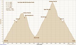
Here’s an interactive Cesium browser View of the 50K course, and an elevation profile generated in SportTracks. Based on my GPS track, the distance worked out to a little over 33 miles, with an elevation gain of about 7600′. The elevation gain was hand calculated using SRTM corrected profile elevations. (For more info about measuring elevation gains on mountain trail runs, see the post What’s the Elevation Gain?)

When split times are available, you can learn a lot about how you, and others, ran the course. Everyone’s race is unique, and no one approach works the best. In the following listings, I’ve calculated the time from the start to each aid station, the time between aid stations, and the split rank at each aid station. These are totally unofficial. In a few places where a split time was invalid (for example earlier than a previous aid station) I’ve substituted estimated times. The “Rank” indicated is based on the time from the start to that point in the course. In both the 50K and 50M the top runners had missing splits, so for that split, they will not be included in the split rankings.

Here are the 50K Split Calculations and the 50M Split Calculations. If you want to send me your corrected or missing splits, I will update the listings when I have a chance. Please see the Twin Peaks 50/50 web site  for official results and information.

Serrano Valley – La Jolla Valley Scenic Loop

Lynn and Frank at the ranch in Serrano Valley.

This is one of my favorite medium length trail runs in the Santa Monica Mountains. It starts at the Ray Miller trailhead and explores the scenic grasslands of the Serrano and La Jolla Valleys. Along the way there are spectacular ocean and mountain vistas from the Ray Miller Trail and the summit of Mugu Peak.


Serrano Valley
Most of the route is on single track trail, and except for a short out & back segment to “The Ranch” in Serrano Valley, it is a complete loop of about 20 miles. Many variations are possible.

One of the better online maps I’ve found of the area is an Interagency Trail Management Map produced by the NPS Santa Monica Mountains National Recreation Area GIS Lab. It shows the status of trails and public lands in the Santa Monica Mountains and is broken into three parts: WestCentralEast. Additional NPS SMMNRA trail management plan maps include Proposed Backbone Trail Facilities and Trails and Proposed Regional Trails.

Here is a Cesium browser View of a GPS trace of our route from the Ray Miller trailhead and through Serrano and La Jolla Valleys.

Related post: Serrano Valley – La Jolla Valley Loop, Serrano Valley from the Chamberlain Trail

Mountain Solitude

Descending from Pallett Mountain on Pleasant View Ridge, in the San Gabriel Mountains.

It was a little eerie. There wasn’t so much as an animal track or old bootprint on the trail ahead. The path was perfectly smooth, and I felt a bit guilty as my running shoes left their patterned tracks under foot. Lynn, Frank, and I were working up the Pacific Crest Trail on the west side of Mt. Williamson in the San Gabriel Mountains, near Los Angeles. As we switchbacked up the trail, the mountain seemed to sigh, happy to have enjoyed at least a few days of solitude.


Angeles Crest Highway
Closed in early September by the Station Fire, this part of Angeles National Forest did not burn. It reopened in October, but is difficult to access because of the continuing closure of Angeles Crest Highway. To get to this point, we had run from the Antelope Valley side of the mountains. First up the South Fork Trail to Islip Saddle, and then along Angeles Crest Highway, through the tunnels, to the PCT near Kratka Ridge. A steep climb up the PCT put us where we were now — nearing the summit of the usually busy peak.

Of course that was part of the fun of trail running. By the time we reached the summit of Mt. Williamson, we would have gained about 3600′ of elevation, and would be a little more than half way through our 21 mile run. From Williamson’s summit we would head west along Pleasant View Ridge, and then descend the Burkhart Trail to Devil’s Punchbowl. The ups and downs along Pleasant View Ridge, and the “minor” climb out from Cruthers Creek, would add another 1500′ or so of elevation gain.


Big horn sheep track
The run up the rugged South Fork trail had been interesting. Low on the trail we had picked up the blocky hoof prints of what was probably a large bighorn sheep. Intent on the tracks, and telling stories of Tom Brown and the Pine Barrens, we almost didn’t notice two deer hunters hiking up the trail ahead of us. Another mile or two up the trail we heard something large moving through the brush, and were surprised to see  a sizable black bear bounding down a slope. I wondered if it might be the sire of the cubs we had seen on this trail earlier in the year. A little higher still, we found a beautifully colored California mountain kingsnake, warming itself in a patch of morning sun.

Those encounters had been a couple of hours before. Now we were just below Williamson’s summit ridge. Reaching the crest, we ran the few remaining yards to its eastern summit. The visibility was stunning. To the south, we could see the thin ribbons of Catalina Island and San Clemente Island, more than 75 miles distant. To the east, Mt. San Jacinto loomed above the shoulder of Mt. Islip. To the north an indistinct line of white floated above the horizon. Was it the Sierra?


The 3 mile traverse of Pleasant View Ridge between Mt. Williamson and Burkhart Saddle was strenuous, but spectacular. The path along the ridge was also untrodden, and it wasn’t until Pallett Mountain that we noticed the first footprints. From Pallett Mountain the route dropped more than 3000′ — much of it excellent running on the Burkhart Trail. It wasn’t until mile 20, when we turned off the High Desert National Recreation Trail and started the mile descent to the Devil’s Punchbowl parking lot, that we finally encountered another person — a runner, jogging up the hill.

Here’s a Cesium browser View of a GPS trace (yellow) of the point to point route, and an elevation profile generated by SportTracks. Using the High Desert Recreation Trail as a connector (red trace in the Google Earth view), the route could be extended to a loop.

Some related posts: Peaks Along Pleasant View Ridge, Pleasant View Ridge Snow

San Gorgonio High Line 2009

San Bernardino Mountain Divide from near Charlton Peak

San Bernardino Mountain Divide from near Charlton Peak

As I approached the spur trail to High Meadow Springs, I tried to convince myself I had enough water to continue. The problem wasn’t the third of a mile detour down to the spring, or even the 280′ loss of elevation. The problem was the interruption. Having to get water was like having to stop to remove an annoying little rock from your shoe. You know you should, but one mile passes, then two… The running along the 10,500′ crest on the Divide Trail was just so spectacular, I didn’t want to stop!

I reached behind my back and squished the Camelbak reservoir with my hand. Yea, there’s plenty of water, I don’t have to stop. I can make it to the summit of Gorgonio, and then get water at High Camp on Vivian Creek on the way down.


But hadn’t I nearly run out of water the last time I did this? I did a rough calculation of the distance… about four miles to the peak, with a gain of 1500′, and then another four miles to the creek. Reluctantly, I slowed, and turned off the Divide Trail

At the spring, I pulled the reservoir from my pack. Only about 25 oz. of water remained. The little spring burbled and gurgled energetically, and it didn’t take long to replenish my water supply. East of Shields Flat, the trail to High Meadow Springs is about a quarter-mile below the point marked 10,500 on the topo, and about half a mile above Red Rock Flat. At an elevation of 10,120′, the springs sit near the top of a steep canyon that drops down to Plummer Meadows. It’s an airy location with an expansive view.

Earlier, I had chugged up the Momyer Creek Trail to the San Bernardino Peak Divide Trail. Once past the turn to Alger Camp, this trail becomes more of a  footpath, weaving its way through a middle elevation forest of pine and fir, around innumerable bark beetle felled Jeffrey pines, and up to a high mountain habitat of chaparral and Lodgepole pine.


If stretches of trail with a 30% grade are not enough of a challenge, the last couple of miles to the divide include overgrown sections that will not only slow the shorts clad hiker or runner, but over time become annoyingly painful. Chinquapin is your friend, manzanita an adversary, and whitethorn your archenemy. And there is a lot of whitethorn.

After visiting High Meadow Springs, I continued down to Dollar Saddle. Beyond this point I expected to see an increasing number of hikers. The previous Saturday it had been exceptionally busy on Mt. San Jacinto, and the weather was even better today. Eventually, near Jepson Peak, I encountered a couple of hikers returning from the summit, and then passed a couple more working up the trail. But that was it — and the summit of San Gorgonio was empty. Unusual for such a perfect Autumn day.

Here’s a Cesium browser View of a GPS trace of the 26 mile route, and an elevation profile generated by SportTracks. The approximate elevation gain and loss was about 7000′.

Related post: San Gorgonio High Line, San Gorgonio Mountain – Falls Creek Loop