Category Archives: trails|pt mugu state park

After the Springs Fire: A Run Through Pt. Mugu State Park

New growth in Pt. Mugu State Park following the Springs Fire

As we rounded a corner on the Old Boney Trail, Ann spotted a deer bounding through a thick, unburned section of brush. Its behavior was unusual — the deer was a few hundred yards away and in heavy cover. We soon saw the reason — a large coyote was trailing the animal and probably had been doing so for time.

We were in the middle of a 25 mile Odyssey through Pt. Mugu State Park, about three weeks after the Springs Fire ravaged much of the park’s 14,000 acres.

Already the process of recovery was underway. Tufts of green were sprouting in many areas. Yucca was beginning to regrow and a few yucca scorched in the fire were blooming. In addition to the deer and coyote described above, over the course of the run we would see another deer; fresh raccoon, bobcat, fox and rodent tracks; a lizard, grasshoppers, many birds, a bee’s nest, and fresh mountain lion scat.

Here is a slideshow of some photos from the run.

Some related posts: Springs Fire Burn Severity, Springs Fire 2013

Springs Fire Burn Severity

Here’s an interactive Google Earth browser view of a false-color image of the Springs Fire scar from the Landsat Data Continuity Mission’s Operational Land Imager. The image was recently featured on the NASA Earth Observatory web site. The image date is May 4, 2013.

According to the description of the image on Earth Observatory unburned vegetation appears dark green. Burned areas are red, and the most severely burned areas are generally the darkest. Actively growing farmland is light green; plowed fields are brown. Buildings and roads are gray.

This is a 3D view that can be zoomed,rotated and tilted. It includes the GEOMAC fire perimeter timestamped 05/07/13 0348. Placemark locations are approximate. GPS tracks from various runs have been added to mark many of the area’s trails. The red track is Sycamore Canyon Fire Road. Requires the Google Earth plugin.

The overlay is large and may take a while to load.

Related post: Springs Fire 2013

Springs Fire 2013

Springs Fire MODIS fire detections as of 05/03/13 1115 MDT

Update May 13, 2013. According to the CAL FIRE website the Springs Fire was 100% contained on May 11 at 24,251 acres. The interactive Google Earth browser view of the Springs fire perimeter has been updated with the fire perimeter from GEOMAC timestamped 05/07/13 0348. This is a 3D view that can be zoomed, rotated and tilted. Placemark locations are approximate. GPS tracks from various runs have been added to mark many of the area’s trails. The red track is Sycamore Canyon Fire Road. Requires Google Earth plugin.

Today SMMNRA announced that some areas closed by the Springs Fire will reopen tomorrow morning. Rancho Sierra Vista in Newbury Park will partially reopen, the Sandstone Peak and Mishe Mokwa trailheads will reopen, and the Backbone Trail east of the Point Mugu State Park boundary will reopen. Also, see the SMMNRA news release After the Fire: 3 Things You Can Do to Help Nature Recover and the SMMNRA Photostream on Flickr.

Previous snapshots:

Springs Fire fire perimeter from GEOMAC timestamped 05/06/13 0555.

Springs Fire fire perimeter from GEOMAC timestamped 05/03/13 2345.

Springs Fire MODIS fire detections as of 05/04/13 1315 MDT with GEOMAC fire perimeter timestamped 05/03/13 2345.

Springs Fire MODIS fire detections as of 05/04/13 0800 MDT.

Springs Fire MODIS fire detections as of 05/03/13 2215 MDT.

Springs Fire MODIS fire detections as of 05/03/13 1700 MDT.

Springs Fire MODIS fire detections as of 05/03/13 0845 MDT.

MODIS Google Earth fire data is from the USDA Forest Service Remote Sensing Applications Center Active Fire Mapping Program web site. Fire perimeter is the most recently available from the GEOMAC website at the time this post was updated.

The following additional information was included with the MODIS fire detections KML file:

This KML displays the MODIS fire detections at a spatial resolution of 1km for the past 6 hours, 6-12 hours, 12-24 hours, and the previous 6 day period. Each 1km MODIS fire detection is depicted as a point representing the centroid of the 1km pixel where the fire is detected. The 1km footprint of the MODIS pixel for each detection is also displayed.

KML file generated by the USDA Forest Service Active Fire Mapping Program.

Disclaimer: Although these data have been used by the USDA Forest Service, the USDA Forest Service shall not be held liable for improper or incorrect use of the data described and/or contained herein. The information contained in these data is dynamic and is continually updated. This disclaimer applies both to individual use of the data and aggregate use with other data. The USDA Forest Service reserves the right to correct, update or modify this data and related materials without notification.

Giant Coreopsis Along the La Jolla Canyon Trail

Giant Coreopsis Along the La Jolla Canyon Trail

If a sunflower could be crossed with a Joshua tree the result might look like Giant Coreopsis (Leptosyne gigantea).


As tall as six feet, this peculiar plant looks as if it belongs in some distant place, if not some distant time.

It is a member of the Sunflower family and its bright yellow flowers and feathery green leaves create impressive displays on Southern California coastal slopes following Winter rains. It is well-adapted to our Mediterranean climate, its leaves withering and the plant becoming dormant in the dry months.

These are along the La Jolla Canyon Trail in Pt. Mugu State Park and were photographed on Saturday’s run to Mugu Peak from Wendy Drive.

Back on the Backbone Trail

La Jolla Valley and Boney Mountain from the east side of Mugu Peak.

What time was it? 1:00 AM? And I was going to get up at what time? 6:00 AM? And do what? Run to Mugu Peak?

It made sense a few days ago. Do a long night training run, sleep for a few hours, then get up and do another long run.

I couldn’t believe it when I woke at 6:15. OK… OK… I’ll give it a shot. Bleary-eyed, I drove to Wendy Drive.

The forecast was for another day of record-breaking highs. By Southern California standards most of the Winter had been cool and sometimes even cold. I was sure that a temperature of 80-something was going to feel more like 90-something.

Most of the first few miles of Sycamore Canyon were downhill, shaded and cool. As I passed the Danielson Multi-Use Area it was weird to think that last night we had turned around just a couple of miles up the Backbone Trail from here. Danielson will be around mile 59 of the ultra. Running in the dark and after many miles of technical single track trail, Sycamore Canyon road will hopefully provide at least a bit of mental relief. One foot in front of the other…

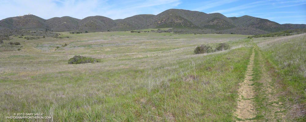
This morning I continued to follow the Backbone Trail down Sycamore Canyon and then up the Wood Canyon Vista Trail to the Overlook fire road. Here the Backbone Trail continues left (south) to the Ray Miller Trail. Today I turned right and at the 4-way intersection a little down the road turned left and headed into La Jolla Valley — one of the “must visit” places in the Santa Monica Mountains. Mugu Peak is on the south side of La Jolla Valley, and stands above the coast at Pt. Mugu.

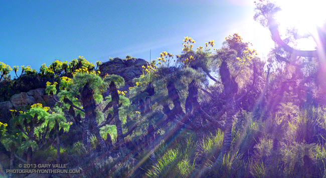
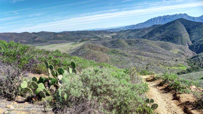
The title photo was taken from the trail on the east side of Mugu Peak. The eastern part of La Jolla Valley is on the left (above the cactus) and La Jolla Canyon is on the right. Boney Mountain is in the distance. The Chamberlain segment of the Backbone Trail descends from near the high point on the right side of the skyline.


There are several ways to return to Wendy Drive from Mugu Peak and my favorite route is nearly all single track trail. Not today. Today wherever there was a choice I took the one that would have the most shade and water faucets. That meant descending Hell Hill instead of Wood Canyon Vista Trail, and running back up Sycamore Road instead of using the single track trails on the west side of the canyon.

It took a while, but eventually I made it back to the car.

Some related posts: Back to Mugu Peak; Laguna Peak, La Jolla Valley, and the Channel Islands