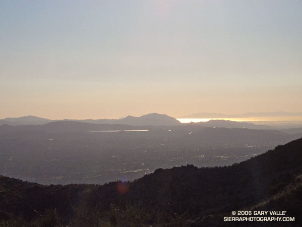
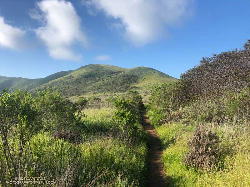
Simi Valley, Conejo Mountain, the Oxnard plain, Santa Barbara Channel, and the Channel Islands from the Chumash Trail.
Conejo Mountain is about 21 miles away, and the nearest point on Santa Cruz Island is about 50 miles distant.

Simi Valley, Conejo Mountain, the Oxnard plain, Santa Barbara Channel, and the Channel Islands from the Chumash Trail.
Conejo Mountain is about 21 miles away, and the nearest point on Santa Cruz Island is about 50 miles distant.
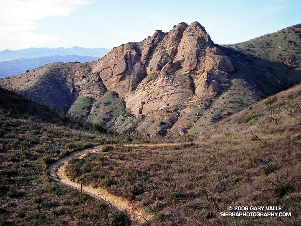
Practically any objective can be a good excuse for an adventure. Each time up or down the Chumash Trail, I pondered the prominent rock formation northwest of the trail and wondered what I might find there.
My first thought was to find a direct route across the deep canyon that parallels the Chumash Trail. Recons from a couple of points on the trail revealed this was a bad idea. Sections of the canyon that looked passable from above were incised, with crumbling, near-vertical walls. A Plan B was required.
A look at a topo map suggested it might be possible to access the formation from Las Llajas Canyon. An advantage of this approach was that, if it worked, it could be part of a loop. On a cool January morning, I decided to give it a go.
From Las Llajas Canyon, an old, overgrown roadbed led up a side canyon to a point where there was no obvious route. The canyon bottom did not look promising, and steep slopes bounded both sides of the canyon. After scrambling several hundred feet up a south-facing slope, I found a deer trail that seemed to be headed in the direction I wanted to go.
This game trail was the key. It reflected the cumulative experience of many deer dealing with the terrain issues I faced. It was remarkably efficient and appeared to be the path that expended the least energy to reach the main ridge. That is, if you’re a deer. At one point, I was forced to backtrack when the trail crossed a steep, exposed slope better suited to those with four legs and cervid hooves.
Once on the main ridge, it didn’t take long to reach the rock formation.
According to the Dibblee geologic map of the area, the formation is positioned on the south branch of the Simi Fault. The steeply inclined layers of cobble that are embedded in the formation might have been deposited as part of a fan delta some 60 million years ago. This cobble is also encountered at several places along the Chumash Trail.
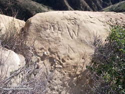
Near the summit of the formation I found some chiseled inscriptions. They were very weathered. The most prominent might be either a “93” or “33” over the top of a “W,” and another is perhaps a “DH.” It’s hard to tell.
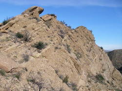
Of the three high points comprising the formation, I scrambled to the top of two. The easternmost summit (on the far right when viewed from the Chumash Trail) involved climbing on loose cobble, and looked like an accident waiting to happen. Here’s a photo from the middle tooth, looking down the ridge.
As I climbed down from the summit to a saddle northeast of the rock formation, I spooked a deer, and it bounded into a brush-filled gully.
Continuing up the ridge, it eventually intersected Rocky Peak Rd. at its high point near some bivalve fossil beds. According to the Dibblee map, these are much younger than the rock formation’s cobble and may have been deposited in shallow marine conditions or lagoons a couple million years ago.
At Rocky Peak Rd. I had the option of returning via Las Llajas Canyon but decided to complete the approximately 8-mile route using the Chumash Trail.
This interactive, 3D terrain map shows the approximate route used to get to Chumash Rock and then complete the loop. The hike/run was on January 29, 2006.
Rocky Peak Road is an exceptionally popular hiking and biking trail that starts at Santa Susana Pass, on the north side of the 118 Freeway. Regardless of the time of day or weather I ALWAYS see someone on this trail.
The plan for this afternoon’s run was to do an out and back on Rocky Peak Road to the top of the Chumash Trail (3.8 miles) or to Fossil Point (4.8 miles).
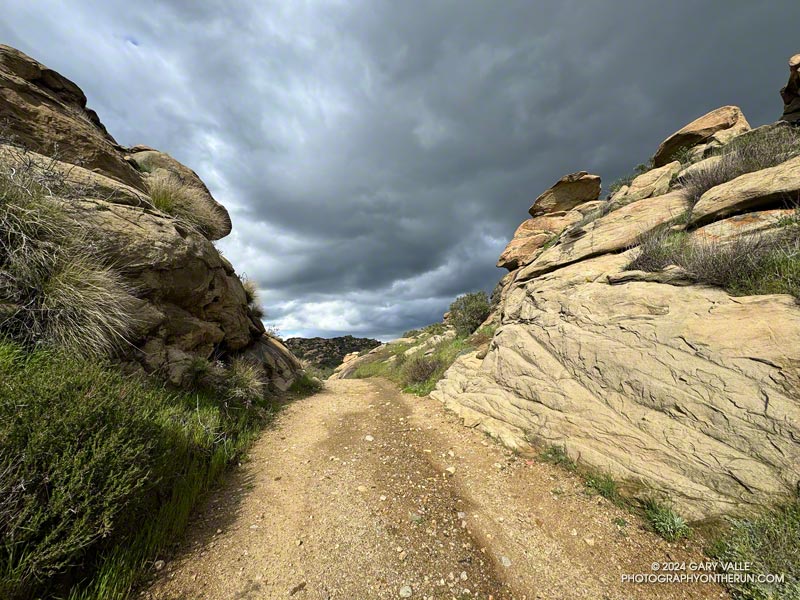
Another runner was finishing their workout as I started up the initial steep climb. Glistening in the warm sun, runoff from yesterday’s storm streaked some of the sandstone rocks, and ephemeral streams gurgled in the ravines and gullies.
Thanks to the sandstone geology, the dirt road wasn’t as muddy as most other local trails would be. Although heavily eroded from numerous Winter storms, it was still near the top of my list of places to run during periods of wet weather.
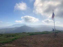
In the aftermath of yesterday’s storm the weather was spectacular. The temperature was warm enough to run in shorts and short-sleeves but still comfortable chugging up Rocky Peak Road’s steep hills. Puffy cumulus clouds filled the sky, creating postcard views at every turn.
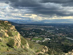
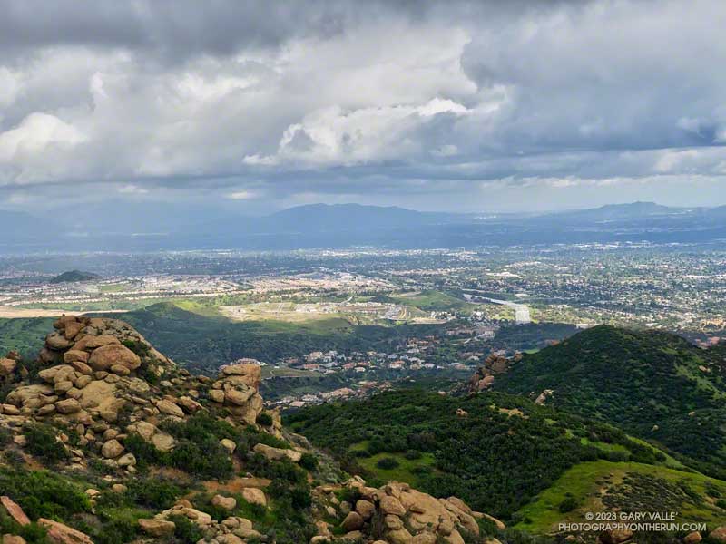
More focused about getting up the hill than any weather concerns, I continued past the top of the Hummingbird Trail and through a gap in the rocks to a section of road with a good view of the San Fernando Valley and San Gabriel Mountains.
I’d been in a situation similar to this several times on Rocky Peak. As a storm moves east from Los Angeles, energy circulating around the low can sometimes result in “back-door” precipitation. In this scenario, clouds build-up over the mountains to the north and then drift over the San Fernando Valley, producing showers — and sometimes — thunderstorms.
But today’s scenario was a bit more complicated. A much larger area, extending east to the San Gabriel Mountains, was rapidly destabilizing. What had been a picturesque sky at the start of the run was now congested and ominous. The question wasn’t so much if it was going to rain, but if a thunderstorm was going to develop.
As I continued up the road, the sky darkened, the temperature cooled, and the wind became more gusty and fitful. A little chilly, I pulled on my arm sleeves. I laughed nervously as I mistook the roar of a passing jet for thunder. That was a jet, right?
When people say they are “doing Rocky Peak,” they are often referring to a high point on Rocky Peak Road that is west of the actual peak and about 2.4 miles from the trailhead. The final climb to this high point is a good one — gaining about 450 feet over three-quarters of a mile.
The road on this stretch is oriented in such a way that the terrain hides the view to the north. I was anxious to get to the top of the hill so I could get a better idea of what the weather was doing. As I worked up the road, I would occasionally feel the cold splash of a raindrop on one leg or the other.
Nearing the top, I thought, “I may get wet, but at least there’s been no thunder.” Within seconds of that proclamation, and as I reached the highest point, there was a long, loud, crackling peal of thunder.
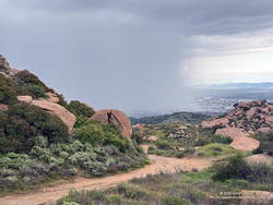
One look at the sky and all thoughts of continuing to the Chumash Trail were gone. I turned around and started running down the hill, hoping to avoid the worst of the storm.
First one pea-sized hailstone hit the ground, then another, and then a sleety barrage of rain and hail poured from the sky. Instantly soaked, I shuddered as thunder echoed overhead and cold rain ran down my back. Muddy water flowed in rivulets down the sodden road and I cautioned myself to run fast, but not too fast.
I didn’t expect to outrun the storm, but hoped I might move to a part of it that was less intense. And that’s what happened. As I descended, the deluge gradually diminished. Most of the activity seemed to be behind me and a little to the east.
By the time I got down to the Hummingbird Trail, it was only sprinkling. The strong cell that had been over Rocky Peak had drifted southeast, and was now over the Porter Ranch – Northridge area.
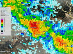
National Weather Service Doppler Radar tells the story. At the start of the run there were scattered, mostly weak echoes. At 3:06 pm, as I was starting up the last long hill, a cell northwest of Rocky Peak was developing and drifting southeast. Over the next 16 minutes the cell continued to move southeastward and strengthen, and at 3:22 pm was over the Rocky Peak area. I turned around and started down as the cell moved into that area.
The cell over Rocky Peak continued to strengthen, and at 3:39 pm had drifted over the Porter Ranch – Northridge area. At 3:44 pm the NWS issued a Severe Thunderstorm Warning for Western Los Angeles County.
Here are a GOES-18 satellite loop and Doppler Radar loop that show the development and track of the Rocky Peak thunderstorm.
Some related posts:
– Rainy Weather Running on Rocky Peak Road
– Running Between Raindrops: Chumash Trailhead to Rocky Peak
– Thunderstorm
After doing a climbing /trail running combo in Pt. Mugu State Park last Sunday, I headed back to Wendy Drive this morning to do a trail run to Mugu Peak and back.
The plan was to get in a long run (20 miles) with fewer “get your feet wet” stream crossings, and also check out the conditions on several trails I hadn’t done this year.
So much for keeping the feet dry! The temp was in the mid-30s when I turned off Big Sycamore Canyon fire road and onto Wood Canyon fire road. The main creek draining Sycamore Canyon cuts across the fire road here, and there was no way I was going to get across it without wading. Some smaller stream crossings followed, ending with Wood Canyon Creek.
My shoes were squish-squashing loudly as I started up Hell Hill. The 600′ climb was almost enjoyable with the cool temperatures. Partway up, a slurry of rock and mud had flowed from the hillside onto the road — the soil saturated from storm after storm.
Several trails/roads converge at the top of Hell Hill, and I turned right onto the fire road that leads to the La Jolla Valley Loop Trail. I like to do Mugu Peak as part of a counterclockwise loop that combines segments of the La Jolla Valley Loop Trail and Mugu Peak Trails.
Long stretches of the La Jolla Valley Loop Trail between the walk-in camp and Mugu Peak were sopping wet. I’ll be curious to see how quickly it dries out, but today (April 2) it was really, really wet.
Mugu Peak was pretty much as it always is on this side — busy and steep. The steepness of the “Direct” trail helped wring the water from my Ultraglides and Injinji socks. By the time I reached the top, my feet were only damp.
Mugu Peak is VERY popular, and there are almost always a few people taking in the wide-ranging views from the summit. Most do the short, steep hike from PCH on the Chumash Trail. A few start at the Ray Miller Trailhead — or like I was doing today — the long route from Wendy Drive.
Although I usually climb the peak, two other options are worthwhile: the loop around the ocean-facing side of Mugu Peak and
the loop around La Jolla Valley.
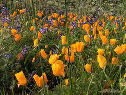
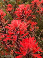
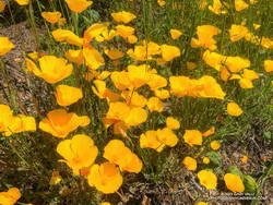
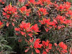
The wildflowers along the Mugu Peak Trail and La Jolla Loop Trail were fantastic. California poppies were plentiful on the south-facing slopes. The vibrance of the bright orange poppies could not have been better accentuated than by purple lupine. Yellow bush sunflower, royal blue phacelia, and rich red paintbrush also decorated the trail.
I followed my usual route on the way back to Wendy — returning to the Hub, descending Hell Hill, retracing my steps in Wood Canyon, then following the Two Foxes single-track trail north to a short connector to Sycamore Canyon Road. This is near the Danielson Multi-Use Area. Once on Sycamore Canyon Road, the route back was the same as last week — up 1.8 miles of paved road and then onto the Upper Sycamore Trail. After that, up Danielson Road and across Satwiwa to the Wendy Drive trailhead.
Here is an interactive, 3D terrain map of my GPS track to Mugu Peak and back from Wendy Drive. To change the view, use the control on the upper right side of the screen. Track and placename locations are approximate and subject to errors. Poor weather and other conditions may make this route unsuitable for this activity.
Also, see the archived maps of Rancho Sierra Vista/Satwiwa and Pt. Mugu State Park from the NPS website, and the maps of Pt. Mugu State Park on VenturaCountyTrails.org.
Some related posts: Out and Back Trail Run to Mugu Peak, Running to Serrano and La Jolla Valleys from Wendy Drive, Busy Mugu Peak
I like splashing through streams as much as anyone does, but today I wanted to try and keep my shoes and socks dry. This Winter that’s been surprisingly hard to do.
Weekdays, I often run from the Victory trailhead at Ahmanson Ranch over to Las Virgenes Canyon and back. But it had rained in the Los Angeles area for four days straight. There was just no question that Ahmanson was going to be wet and muddy, and Las Virgenes Creek would be too wide to jump. I’d have to wade the creek crossings — again.
That’s why this afternoon, I was doing an out-and-back run on Rocky Peak Road from the 118 Frwy trailhead. As a result of the area’s sandstone geology, Rocky Peak Road is usually a pretty good place to run during periods of wet weather. For one thing, there are no creeks to cross. Plus, the rocky and sandy road doesn’t have many areas of “glob on your shoes” mud. It also has excellent views of the San Fernando and Simi Valleys and surrounding mountains.
My turnaround point today was the top of the Chumash Trail, which is a little less than four miles from the Rocky Peak trailhead. I sometimes continue past the Chumash Trail another mile to Fossil Point.
Today, there was one short, muddy stretch that could be mostly avoided and a few large mud puddles I could walk around. At the end of the run I didn’t have to switch shoes to drive home!
Some related posts: A Bear on Rocky Peak Road, Chilly Rocky Peak, Mountain Lion Tracks on Rocky Peak Road, Rocky Peak Vernal Pool
Wait a minute… I stopped running down the hill and walked back to look at the sizable pile of scat.
I was on Rocky Peak Road, at about mile 3 of an extended version of the Chumash – Las Llajas loop, and just past the top of the Chumash Trail.
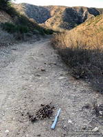
No doubt about it. It was bear scat. The bear had been eating holly-leaved cherries, and the scat was full of cherry pits. Over several decades of running Rocky Peak Road, this was the first time I’d seen evidence of a bear in the area.
Bears aren’t particularly common here, but they are seen from time to time. I wondered if this was the bear that had been discovered in the kitchen of a Simi Valley home in early September.
Bears have also been captured on local trail cams. In December 2015, the NPS photographed a bear and her cub feeding on the carcass of deer in the Santa Susana Mountains. Even more remarkable, in July 2016, a bear was photographed in Malibu Creek State Park by an NPS camera trap.
This morning, I looked for bear tracks around the scat, but thunderstorms and bike traffic had erased them. After taking a couple of photos, I continued toward the high point of the loop, “Fossil Point.”
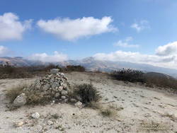
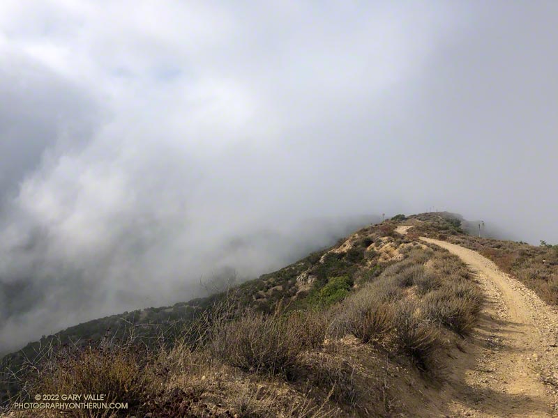
What had started as a very foggy morning was transitioning to a cool Fall day with a mix of sun and clouds. From the cairn at Fossil Point, Oat Mountain was still partially shrouded by clouds. Below the overlook, I spotted a couple of mountain bikers working up the road. The ride up Las Llajas Canyon has become a popular e-mountainbike ride, and e-bikes would be the only type of bike I would see on my way down the canyon.
The run down Las Llajas Canyon was pleasant and fast-paced. Lately, I’ve been doing a variation of the loop that jumps over to the Marr Ranch Trail using a trail that splits off the Coquina Mine trail. This route gets you up and out of the canyon and onto a ridge with good views of the surrounding terrain. It’s a bit more adventurous and adds a little mileage and elevation gain to the usual loop. The Coquina Mine trail is easy to miss — it branches off Las Llajas Road after passing the towering cliffs.
Here’s an interactive, 3D terrain view of a GPS track of the extended Chumash – Las Llajas loop. The map can be zoomed, tilted, rotated, and panned using the navigation control on the right. Track and placename locations are approximate and subject to errors. Poor weather and other conditions may make this route unsuitable for this activity.
Some related posts: Chumash-Las Llajas Loop, Not So Flat Las Llajas Canyon, Exploring Las Llajas, Marr Ranch Wildflowers