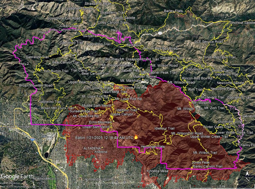
The information in this post may be incorrect or out of date. For official information see the Eaton Fire incident page on Inciweb, the Angeles National Forest updates on Facebook, and the Angeles National Forest website. The perimeter is from the Wildland Fire Interagency Geospatial Services (WFIGS) Group and National Interagency Fire Center (NIFC).
This interactive, 3D terrain viewer shows the Eaton Fire perimeter, along with GPS tracks of some trails in the area. Also shown is the approximate closure boundary (magenta) as described and depicted in Angeles National Forest Order No. 05-01-25-05 (Jan 29, 2025). The initial view can be changed using the control on the upper right side of the screen, the CTRL key and your mouse, or touch gestures.
Due to inconsistencies in the CLOSED AREA DESCRIPTION in the order, and the boundary shown on the Forest Service closure maps, the eastern boundary of the closure area could not be determined. For example, the CLOSED AREA DESCRIPTION describes the boundary continuing “south along the Winter Creek Trail” and then “south along the Upper Winter Creek Trail to Chantry Flat Road.” The closure maps published by the Forest Service do not show this.
The Gabrielino Trail in Santa Anita Canyon appears to better match the border depicted in the Forest Service maps. However, because of the low resolution of the Forest Service maps, it is impossible to be sure. There are other inconsistencies as well. For example, in the Forest Service’s overview map of the closure, the Sturtevant Trail is shown as open (green), but in the order, it is one of the trails listed as closed.
It looks like the area that didn’t burn within the Eaton Fire Closure Area may be larger than the area that did burn. When there is a plausible, atypical threat to public safety from the fire, such closures may make sense. However, the trails in these unburned areas often remain part of a long-term closure. Popular trails outside of the Bridge Fire Burn Area, such as the Devil’s Backbone, Ski Hut/Baldy Bowl, South Hawkins, and Hawkins Ridge Trails, are still listed as closed for the remainder of 2025!
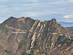
The following trails are listed as closed in Forest Order No. 05-01-25-05. Several of these trails are entirely outside of the Eaton Fire Burn Area.
Mount Wilson Trail
Winter Creek Trail (Upper)**
Winter Creek Trail (Lower)**
Idlehour Trail
Castle Canyon Trail
Sam Merrill Trail (Lower)
Sam Merrill Trail (Middle)
Sam Merrill Trail (Upper)
Echo Mountain Trail
Mount Lowe West Trail
Mount Lowe Trail (East)
Tom Sloane Trail
Gabrielino National Recreation Trail**
Bear Canyon Trail**
Ken Burton Trail**
Mount Zion Trail**
Sturtevant Trail**
Sturtevant Loop**
**Outside of Eaton Fire Burn Area. The Winter Creek Trail above Hoegee’s passes through a 60 yd. stretch of the Burn Area at one point.
Trails aren’t just lines on a map. Each and every trail is a valued resource that shouldn’t be closed for years under the guise of public safety, or because the trail happens to be on the wrong side of a section line, road, or other feature that is convenient to use as a closure border.
Hopefully, the Eaton Fire Closure Order will be modified when the Forest Service determines that the threat from the Eaton Fire has passed.
Related post: Bridge Fire Perimeter, Approximate Closure Boundary, and Some Area Trails