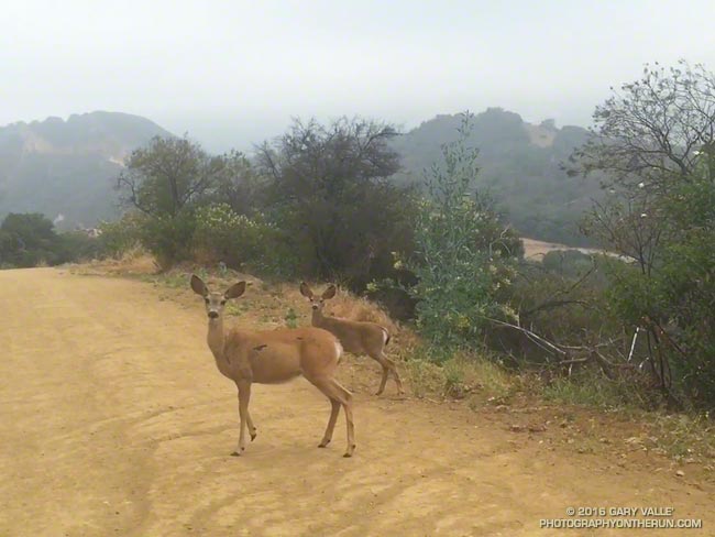
Mule deer are common in the Santa Monica Mountains. I see them most frequently in Topanga State Park, near Trippet Ranch, and in Malibu Creek State Park.
My intent was to try and walk past without scaring them. One doe did not run, but the youngster and its companion were more skittish and didn’t quite know how to react.
In some situations a bolting deer can be a real problem. Two friends running in Topanga State Park rounded a corner and were suddenly confronted with a spooked buck running toward them. There was a steep hill on one side and a cliff on the other. In the narrow confines the buck collided with one of the runners, hitting his shoulder and knocking him to the ground. All things considered he was very lucky. The bucks head was up, so the collision only resulted in a sore shoulder and some trail rash.
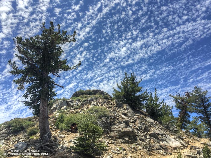
Crest and clouds on the Pacific Crest Trail at 8900′ near Mt. Burnham in the San Gabriel Mountains. From Saturday’s 30 mile training run on the PCT and AC100 course.
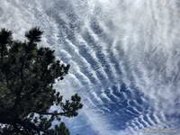
Cirrocumulus undulatus clouds
Temps were a bit more manageable on Saturday than Sunday. Saturday the Big Pines RAWS (6964′) recorded a high of 79°F with an “in the sun” temperature of around 101°F. Sunday the Big Pines high was 89°F with a sizzling “in the sun” temperature of about 109°F.
In addition to the air temperature many Remote Automated Weather Stations (RAWS) report the fuel temperature. The air temperature is the temperature inside a ventilated, sun-shielded enclosure approximately 6 ft. off the ground. The fuel temperature is the temperature of a pine dowel in full sun near the ground. The fuel temperature is a good indicator of the much higher temperature runners and hikers can experience in exposed areas facing the sun.
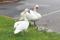
What do a hilly marathon, a pair of cygnets, and a herd of bison have in common?
Why, of course, a run in San Francisco.
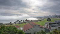
Crissy Field and the Golden Gate Promenade
Brett wanted to check out some of the hills on the San Francisco Marathon course and show me more San Francisco sights. The result was a 14 mile loop that began in the Marina District and visited Crissy Field, the Golden Gate Bridge at Fort Point, Land’s End Park, Sutro Heights Park and Golden Gate Park.
Most of the run between the Golden Gate Bridge and Golden Gate Park was on the California Coastal Trail. Near Sea Cliff we left the marathon course and continued on the Coastal Trail to Land’s End Park and Sutro Heights Park, eventually entering Golden Gate Park on its northwest corner at 47th Avenue.
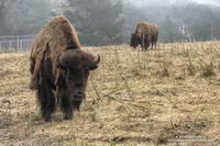
Bison in Golden Gate Park
Larger than New York’s Central Park, Golden Gate Park’s many attractions draw millions of visitors each year. That one of those attractions is a golf course isn’t particularly surprising. And you might expect a major city park to have a botanical garden, aquarium and a museum. But would you expect a park in San Francisco to host a herd of bison? I know when I put on my running shoes this morning I wasn’t thinking, “Hope we see some buffalo!”
Bison have been present in Golden Gate Park since the 1890s. According to this Huffington Post article by Fiona Ma the herd was repopulated in 2011 and, “The City and County of San Francisco would excitedly welcome 6 more urban bison members.”
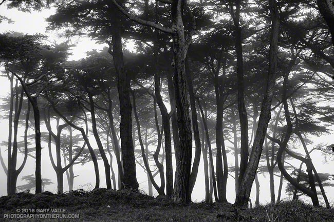
The title photo is a black and white image of Monterey pines along the Land’s End Trail.
It’s been more than six and a half years since the devastating Station Fire burned 160,577 acres in Angeles National Forest.
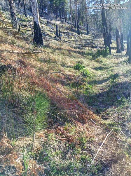
The pine seedling above is on the Three Points – Mt. Waterman trail (10W04) in an area burned by the Station Fire. It’s 3.5 miles from Three Points and at an elevation of about 7000′. It’s about three years old.
How long will the seedling have to grow to replace the mature trees lost in the fire?
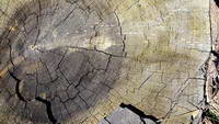
Jeffrey pine burned in the 2009 Station Fire
A couple more miles up the trail, near the Twin Peaks Trail junction, is a Jeffrey pine burned by the Station Fire and then cut by fire fighters. The tree is representative of the mature trees in this area of the forest. An inexact, but conservative, count of its growth rings is in the neighborhood of 325.
So the burned tree was a seedling sometime around 1690. If the seedling survives the drought, increasing temperatures, subsequent fires and droughts, and other maladies that can befall a tree, it will reach the age of the burned tree around 2340.
Here’s hoping that it does, and that the forests will be as enjoyable then as they are now…
Update August 4, 2020. In July 2018 a count of the tree rings of a large Jeffrey pine cleared from the Three Points – Mt. Waterman Trail revealed approximately 500 rings!
A couple of weekends ago we had cool weather for a 28 mile Angeles Crest 100 training run from Islip Saddle to Chilao Flat. It was a bit windy and chilly at Islip Saddle, but once we were up and over the shoulder of Mt. Williamson the wind settled down and the weather for the remainder of the run was near perfect.
This was the second of four supported AC100 training runs, each covering a different section of the course. These organized runs account for just a tiny fraction of the total mileage a runner does to prepare for this event, and much of the mileage is done on the AC100 course.
Where is the AC100 course? Incorporating segments of iconic trails such as the Pacific Crest Trail, Silver Moccasin Trail and Gabrielino Trail, the AC100 starts in the mountain community of Wrightwood, California and ends in Altadena near JPL, traversing a large part of the San Gabriel Mountains.
Mountain weather — even Los Angeles County mountain weather — can be extremely varied and changeable. At about mile 18 the AC100 course reaches an elevation of more than 9,200′, near the summit of Mt. Baden-Powell. On the same day temperatures on the course can differ by 50 degrees or more. One section can be inundated by a flash flood while another is bone dry. During a Spring training run it might be 100 in the sun at Echo Mountain, while it is snowing on Baden-Powell.
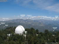
Annotated Mt. Wilson Towercam Image
The Mt. Wilson Towercam is usually pointed in the direction of the Angeles high country. When it is, it provides a great overview of about two-thirds of the AC100 course. The view extends from the top of the Acorn Trail at about mile 4 (in the distance on the far right), along the crest past Mt. Baden-Powell, Throop Peak, Twin Peaks and Waterman Mountain to Three Points at about mile 43. Chilao is hidden from view, but the Charlton Flat area and a section of Edison Road is visible on the left. Newcomb Saddle, at about mile 68, is on the lower right. Here’s an annotated Towercam image that shows the approximate location of these features.
Bill Westphal’s Altadena Weather & Webcam gives a lower elevation view of the San Gabriels, near the AC100 Finish. The view is NE toward the Sunset Ridge Trail and Mt. Lowe Road, around mile 93 or 94. The course goes from the right of the photo to the left, but is mostly hidden from view.
If you are willing to jump through some Java security hoops the Mountain Hardware Live Interactive Cam in Wrightwood is a couple blocks from the AC100 Start. It has views of downtown Wrightwood, Wright Mountain, the Heath Canyon landslide, Blue Ridge and several other locations. I temporarily enabled Java and followed the troubleshooting info linked on the web cam page. I’ve been able to get it to work on a desktop system using Firefox or Internet Explorer. Note that enabling Java and adding non-secure URLs to the Java exceptions list decreases the security of your computer.
Following are several Remote Automated Weather Stations (RAWS) and Weather Underground Personal Weather Stations (PWS) along or near the AC100 course, in order from Start to Finish.
It is important to note that the air temperature given by RAWS stations is the temperature inside a sun-shielded, ventilated enclosure 4-8 feet off the ground. Basically it’s the temperature in light shade. The temperature in full sun can be 15°F higher. I’ve found the “Fuel Temperature” to be a better gage of how hellish it’s going to be on exposed areas of trail. (The Fuel Temperature is the temperature of a ponderosa pine dowel in direct sun.)
Big Pines BPNC1 RAWS (6964′) – Off Hwy 2 near Mountain High Ski Area. Top of Mt. Baden-Powell can be 12+ degrees cooler and much more windy. Was 64°F at 6:54 a.m. for 2015 AC100. Fuel temp at 11:54 a.m. was 92°F.
Chilao CHOC1 RAWS (5450′) – Approximately 1.25 miles WNW of Chilao aid. Fuel temp at 1:53 pm was 95°F for 2015 AC100. Air temp at 6:53 pm was 79°F.
Clear Creek CEKC1 RAWS (3000′) – Approximately 6.8 miles W of Shortcut Aid (~4793′) and 2.9 miles W of Red Box Aid (~4620′). Was 71°F at 8:54 p.m. for 2015 AC100.
Mt. Wilson MWSC1 (5710′) – Approximately 1.5 miles NW of and 780′ above the top of Mt. Wilson Toll Road (~4930′). Compare to JPL 5600′. Was 69°F at midnight for 2015 AC100.
Henninger Flats HNGC1 RAWS (2800′) – Approximately 0.8 miles WSW of Idlehour Aid (~3168′). Marine layer can increase humidity on this section of the course. Was 69-70°F from 4 a.m. to 7 a.m. for 2015 AC100. Fuel temp was 89°F by 11a.m.
Altadena KCAALTAD18 PWS (1214′) – Approximately 0.6 miles S of Finish. For 2015 AC100 temp ranged from 66°F at 2 a.m. to 63°F at sunrise. Temp was 79°F at 9 a.m., 82°F at 11 a.m., and 86°F at 1 p.m. Humidity was high with dew point about 70°F.
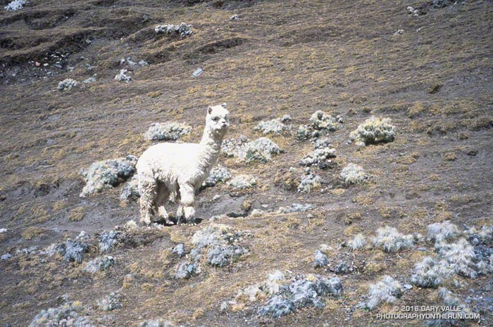
This photograph of an alpaca was taken at about 15,000′, running down from Palomani Pass (16,600 ft.) on a Circuit of Mt. Ausangate (20,905 ft.) organized by Andes Adventures. It was part of a large herd grazing on the mountainside.
We did the circuit in July, which is mid-Winter in the Southern Hemisphere. The alpaca’s thick coat protects it from the harsh, alpine conditions. Temps were relatively moderate when we were there, but still dropped to 0°F overnight.
Evidence suggests the alpaca was domesticated 6000-7000 years ago and bred for its fiber and meat. It is intriguing how much the alpaca’s coat looks like the clumps of cacti growing on the hillside. From a distance an alpaca would be difficult to distinguish from the plants, however this doesn’t appear to be an adaptation. Genetic analysis suggests the alpaca is descended from the vicuña, which has different coloration. The cactus is a species of Oreocereus, commonly called “old man of the Andes.”
Like Llamas, alpacas are camelids, though some claim they are related to Ewoks.