Category Archives: trails

Father’s Day Out & Back to Mt. Baden-Powell

Snow on the PCT below the summit of Mt. Baden-Powell.

Brett was down for Father’s Day, and today we hiked/ran Mt. Baden-Powell (9399′). Baden-Powell is one of the most popular peaks in the San Gabriel Mountains, and several of my favorite trail runs visit its summit.


Lodgepole pine forest
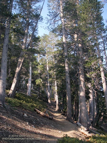
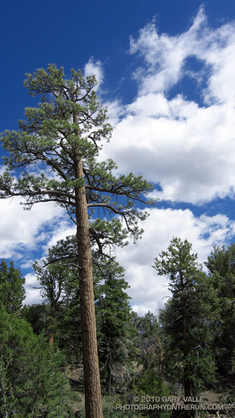
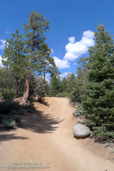
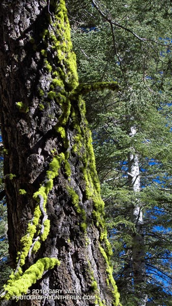
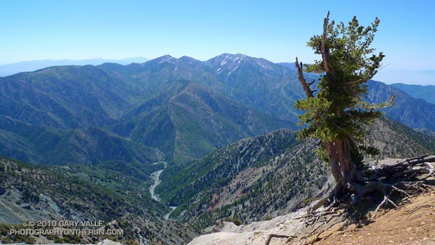
The trail from Vincent Gap switchbacks up through an old-growth forest of Jeffrey pine, sugar pine, white fir and lodgepole pine. There are some impressive trees. The Wally Waldron Limber Pine, near the summit, is estimated to be 1500 years old, and some limber pines in the area are thought to be even older.

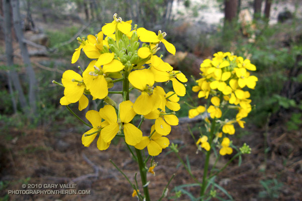
Today, the weather was perfect for pushing the pace. Along the trail fresh green growth could be seen on limb tips of the white firs, and yellow wallflower, red paintbrush, and blue larkspur added a mix of color to the understory.

Not far from the trailhead we had seen fresh Vibram FiveFinger (VFF) tracks headed up the trail, and we were talking about the minimalist shoe. Today Brett was in conventional shoes, but on his home trails about half his runs are in VFFs. He was recounting how the specialists doing a video gait analysis had been blown away when he switched from regular running shoes to VFFs.

I had asked Brett how many miles he had logged on his VFFs, but before he could answer, our conversation was interrupted by a loud shout of “25!” from somewhere on the trail above. A couple of minutes later, and a bit closer, there was another shout of “24!”

Named after the founder of the scouting movement, Mt. Baden-Powell is the culminating point of the scout’s Silver Moccasin Trail. Most summer weekends you’ll find one or more youth groups on their way to the summit of Mt. Baden-Powell. This enthusiastic group was counting down and calling out the 38, 40 or 41 switchbacks (depending on the reference) on the way to the summit.

One of the more interesting hikers on the trail was a hard looking Royal Marine veteran that was thru-hiking the Pacific Crest Trail. Hoping to minimize snow issues on the high Sierra passes, he was a little behind the main wave of PCTers. He had stopped at Lamal Spring to fill some water bottles, and told of hellish temperatures in the desert.


Mt. Baldy from Mt. Baden-Powell
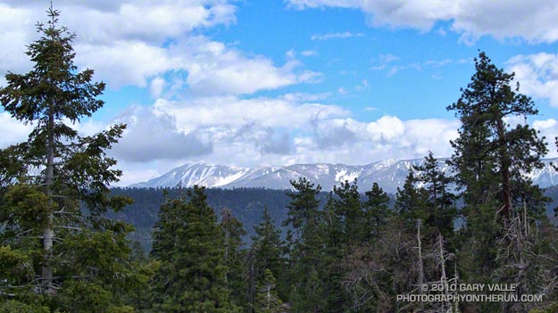
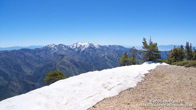
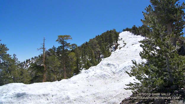
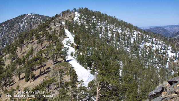
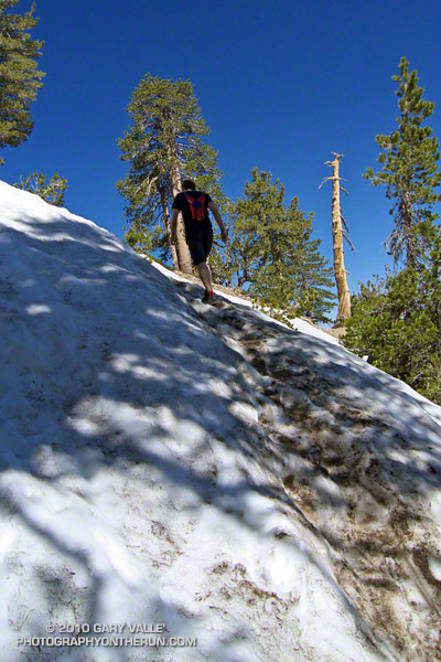
Here the temps had been nowhere near triple digits, but a considerable amount of snow had melted in three weeks since I had last been on the peak. Even so, there were still some large patches of snow on the steep slopes north of the summit, and on the north side of the ridge extending west to to Mt. Burnham.

After topping out, we hiked out along the scenic south ridge of the peak. To the southeast, across the mile deep chasm of Vincent Gulch, some ribbons of snow could still be seen on Mt. Baldy’s north face. After a few minutes we returned to the summit, and began the much easier run down the peak. It was a great way to spend Father’s Day!

Some related posts: Running Hot & Cold, Wally Waldron Limber Pine, Bear Cubs on the South Fork Trail, PCT from Inspiration Point to Islip Saddle

Holcomb Valley 33 Mile Trail Run 2010

Jeffrey pine on the Cougar Crest Trail, near Big Bear Lake.

At aid station #2 we turned onto the Pacific Crest Trail, and followed the smooth single-track through a serene Jeffrey pine forest on the north slopes of Delamar Mountain. It was a little chilly and breezy at 7800′, and the strong June sun felt good on my bare arms. I was at about mile 9 of the Holcomb Valley 33 Mile Trail Run and all was good. The subtle vanilla scent of the pines wafted through the trees, and here and there bright yellow blossoms of western wallflower seemed to mark the way.

Rounding a corner, a pine framed image of Big Bear Lake and snow covered San Gorgonio popped into view. Behind me, a runner exclaimed, “Gorgeous!” As she passed, she commented, “This is my favorite race!” And I can see why. Not only is the race well organized, with great aid stations and super helpful volunteers, it challenges the runner with a unique mix of terrain and altitude.


Some stretches of the course are smooth and fast, some technical, and some downright gnarly. Most of the hills are not steep — at least by sea level standards — and the total elevation gain/loss is only about 3600′. But the gotcha is this: the course has the highest average elevation of any 50K race in Southern California, including the Bishop High Sierra 50K! Nearly 30 miles of the course is above 7000′, and the altitude has an unavoidable effect on performance, particularly for the unacclimatized, middle-of-the-pack runner.

How much of an effect? There is an often referenced chart in the book the Daniels Running Formula that can be used to estimate how much slower we will run at a particular altitude. Using an online running calculator based on the chart, we can project that a runner that does a 33 mile course at an elevation of 1000′ in 6.5 hours would take about 7 hours at 7500′ — assuming the runner is fully acclimatized! In the book, Daniels says that the increase in time could be as much as double for an unacclimatized runner. So 33 miles in 6.5 hours near sea level might turn into 7.5 hours at 7500′.

At altitude, elite runners have an advantage — even more of an advantage than they have at lower elevations. Because of the reduction in air density and drag, running at altitude at their faster pace is more efficient than near sea level. This partially offsets the loss in aerobic power that results from the reduction in atmospheric pressure. Again using the Runworks calculator, a runner that runs 33 miles in 4 hours at 1000′, would be projected to run about 4:18:00 at 7500′.


Apparently immune to the altitude, and flowing over the rocky sections of trail like the wind, Michelle Barton and Jorge Pacheco set new records on the Holcomb course this year. Michelle Barton flew through the 33 mile course in 4:56:21 (8:59 min/mi), and Jorge Pacheco cranked out an amazing 4:13:44 (7:41 min/mi). To put those times in perspective, this year the median time (half the runners above, half below) was  about 7:36:00.

Here is a Cesium ion interactive view of my GPS trace of the 33.1 mile course, and an elevation profile generated in SportTracks. Distances specified are based on the trace, and were calculated in SportTracks. During the race the only segment that seemed significantly longer than expected was from aid station #4 to aid station #5. Part of the reason is it was a tough leg, and has some very rocky stretches. But it also looks like the segment was about 7 miles long, rather than the expected 5.9 miles.

Many thanks to Pam and Gary Kalina, Bear Valley Search & Rescue, the sponsors, and all the volunteers for a great race! All the results can be found on the Holcomb Valley Trail Runs web site.

San Gorgonio Mountain from the Gray’s Peak Trail

Mt. San Gorgonio and the San Bernardino Moutains

Was up at Big Bear Lake this weekend for the Holcomb Valley 33 mile trail run. (More on that in a later post.) Got up to the lake around 2:00 in the afternoon, and on such a fantastic day couldn’t just sit around.

First things first, I had to check out the trail on which the race would begin and end, the Cougar Crest Trail. The trail looked good. It wasn’t too steep, and climbed up through an open forest of juniper, piñon pine, and Jeffrey pine. In hot weather the south facing trail would cook, but with morning temps in the 40’s and afternoon temps around 70, that wouldn’t be an issue. At about the mile mark the trail reached a level spot, and switchbacked left. It was a good point to turn around — I’d see the rest tomorrow.

After a quick side trip to Holcomb Valley to check out another part of the course, I headed over to the Gray’s Peak trailhead. It looked like this trail would have nice views of Big Bear Lake, and all the snow on north facing slopes of the San Bernardino Mountains.

With every switchback, this pretty trail tempted me higher and higher. I was torn between getting the scenic shot that seemed to be just around the next corner, and not overdoing it before the race. After a number of these switchbacks, I had to call it quits. I scrambled to a highpoint and took the photo above. Here’s a larger image that shows the peaks a little more clearly.

The view framed by the trees extends from San Gorgonio Mountain (11,499′) on the left, to San Bernardino Mountain (10,649′) on the right. The peak just right of center, with the large snowfields, is San Bernardino East Peak (10,691′). One of my favorite trail runs climbs from Mill Creek on the other side of the range to San Bernardino East Peak, and then follows the crest to the summit of Mt. San Gorgonio. About 11 miles of the loop course is above 10,000′.

Related post: San Gorgonio High Line 2009

Wolf Lichen on White Fir

Wolf lichen (Letharia vulpina) on white fir

The vibrance of the green caught my eye. Flourishing as a result of a May’s unusually cool, damp, and cloudy weather, the wolf lichen on this White Fir seemed to glow in the morning sun. I was on the Vincent Tumamait Trail, in a dense forest of White Fir and Jeffrey Pine.

The weather at 8500 ft. was idyllic, but here – as elsewhere in the mountains – Spring had been slow to arrive. Scattered patches of snow remained on the forest floor, and the smell of damp soil, warm pine needles, and broken fir limbs filled the air. Exposed by melting snow, the Winter workings of voles wound snake-like across the ground, and I wondered how many mountain canyons had started with the erosion of a vole’s Winter run.

Given its bright chartreuse green color, it isn’t surprising that this lichen (Letharia vulpina) has been used by various indigenous groups to make a dye. Perhaps more of a curiosity is that it is toxic, and has reportedly been used as a poison, and medicinal remedy.

From Sunday’s trail run in the Chumash Wilderness.

Some related trail runs: Fresh Air Traverse, Mt. Pinos – Mt. Abel Out & Back

Running Hot & Cold

Mt. Baldy from the summit of Mt. Baden-Powell

Mt. Baldy fron the summit of Mt. Baden-Powell

Yesterday, Woodland Hills topped the 90° mark for the first time this year. But somebody forgot to tell the local mountains about the warmup. This morning, I was about a mile into an out and back trail run from Islip Saddle to Mt. Baden-Powell, and with the wind chill, it felt like the temp was in the 40’s.

It was chilly in running shorts, and I debated pulling some warmer clothes from the pack. In addition to a short-sleeve shirt, I did have on a pair of pull-on long sleeves. For the moment that seemed to be enough. Rounding a corner, the trail leveled, and up ahead I could see a hiker headed my way. Based on the time, I figured he was descending from Little Jimmy Campground. We exchanged greetings, and as we passed, he commented, “you know there’s a lot of snow on the trail.”


Snow on the crest near Mt. Baden-Powell
This Spring the weather in California has been dominated by a series of cool troughs, slowing the snow melt and in some cases adding to it. It its May 27th Summary of Snow Water Content, California Cooperative Snow Surveys reported the statewide snowpack at nearly twice the normal amount for the date. Squaw Valley reopened for Memorial Day weekend; and with over 100 inches of snow since April 1, Mammoth Mountain plans to operate through July 4.

On the shaded, north facing slopes of Mt. Islip there was more snow than I’d seen since the Spring of 2005.  It couldn’t be avoided. However, the route was well-traveled, and where there was snow, dirt-covered steps eased the way. I had picked up a short length of downed fir, and it worked OK as a crude ice axe, or if you prefer, a stubby trekking pole. It enabled me to move a little faster, and had the added benefit of keeping my upslope hand out of the snow.


Seedling Jeffrey Pine in ghost forest
It didn’t take long to reach Windy Gap (7588′), and soon I was working up the trail to the gap above Windy Gap. Here the trail winds through a ghost forest of old growth trees, burned in the 2002 Curve Fire. Recovery has been slow, and it was heartening to see a young Jeffrey pine in the midst of all the deadwood. It also gave me a sobering perspective of the time that was going to be required for the recovery of the forests decimated by the Station Fire.

The trail climbs up to the crest of the San Gabriels near peak 8426, about a mile east of Windy Gap. From here it more or less follows the prominent divide all the way to Mt. Baden-Powell (9,399′). It’s the “more or less” part that’s key in a snowy year. The shaded north side of the divide may be completely snowbound, while the crest and south side are snow free. The way the ridgeline is oriented, storm winds create deep bands of snow along and just north of the crest. In places the trail can be buried in several feet of snow.


Snow on the crest east of Mt. Burnham
On the east side of Mt. Hawkins I checked out a tree that had been struck by lightning, and then continued along the ridge. The wind was little more than a breeze now, and the temperature comfortable. I pulled off my running sleeves, and then followed the trail across the warm, south facing slopes of Throop Peak. Sometimes on the trail, and sometimes on the crest, I descended to a saddle and then climbed up and over Mt. Burnham (8997′).

On the summit of Mt. Baden-Powell there was almost no wind. The sun was warm and the air clear. Across Vincent Gulch Mt. Baldy gleamed alpine white, its summit ridges still heavy with corniced snow. Many miles to the east, snow could also be seen on San Gorgonio Mountain, and Mt. San Jacinto. A Clark’s nutcracker complained raucously from the top of a Lodgepole Pine, and I assured the bird that I would be leaving the summit soon.

Some related posts: San Gabriels High Five, Islip Saddle – Mt. Baden-Powell Out & Back

Updated Station Fire Closure Boundary with NASA Ikhana BAER Image Overlay

In November 2009 NASA used its Predator B remotely piloted aircraft “Ikhana” to collect post-burn assessments of the Piute Fire in Kern County and the Station Fire in the Angeles National Forest. This interactive Cesium browser View shows the area of the San Gabriel Mountains burned in the Station Fire, with an overlay of the Ikhana Burned Area Emergency Response (BAER) image. (Image courtesy of NASA Dryden and NASA Ames.)

According to NASA, the various purple hues are indicative of the differences in burn severity. The view can be panned, zoomed and tilted (help info) in order to get an idea of the burn severity along a particular trail, or in a particular area. This can be used with other assessment data and on the ground observations to evaluate burn severity. Here is the BAER Station Fire Soil Burn Severity Map (1.1MB PDF) from the Forest Service. Additional BAER information can be found on the Angeles National Forest Station Fire BAER page.

Earlier this week Angeles National Forest reopened some areas of the forest closed by the Station Fire, and issued Forest Order 01-10-02, redefining the boundary of the Station Fire Closure Area. The magenta line in the previous view, and in this Cesium browser View without the burn severity overlay, is the approximate boundary of the Station Fire Closure Area as derived from Angeles National Forest Order No. 01-10-02, Exhibit A and Exhibit B. The boundary, as depicted, is intended to provide a general overview of the closed area — not an exact rendering. Please contact Angeles National Forest to determine whether a particular resource is open or closed. Note, for example, that a road may be open or closed depending upon which edge of the road is the boundary.

One of the reasons for putting this information together was to check the status of several peaks and trails. With so much of the forest closed it is essential that every trail and area that is in reasonable condition be opened to the public. For example, the north approach and summit of Twin Peaks are outside the burn area but remain closed. The trail from Buckhorn to Twin Peaks Saddle and up to the peak should be open, and if the short section of trail burned near Three Points is OK, trail 10W04 from Three Points to Mt. Waterman and Twin Peaks should be opened.

GPS traces of some trail runs inside and outside the Station Fire area have been added to both Google Earth views, along with links to related photos and stories. Trail runs that fall partially or entirely inside the closure area have a red label. Click on the green hiker icon for additional info. Some placenames have also been added –the locations should be considered approximate.

The views also include a partial track of the Pacific Crest Trail (2009 ver. 1) from the Pacific Crest National Scenic Trail website. Note that the PCT is closed in the Station Fire Closure area and the northbound PCT has been rerouted at Islip Saddle. See the Pacific Crest Trail Association website for more info.