Category Archives: weather

Point Reyes Peninsula – A Hidden Island

Running on Kelham Beach, Point Reyes National Seashore

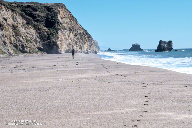
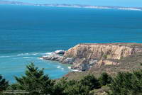
The sand was compact, the breeze cool, the surf up and the running oh so pleasant. Brett and I were running south along Kelham Beach, an idyllic stretch of sand between Point Resistance and Miller’s Point within Point Reyes National Seashore. If the tide was not too high we hoped to reach an area of dramatically folded strata along the 150′ tall sea cliffs.

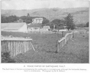
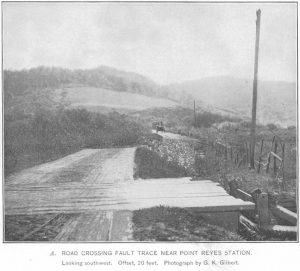
Our adventure had started with a short run from the Bear Valley Visitor Center to a spot on the San Andreas Fault where a fence was reconstructed to illustrate how the Point Reyes Peninsula lurched 16 feet to the northwest during the 1906 San Francisco earthquake. Fences and roads in the Point Reyes area built across the fault trace were offset by as much as 20 feet during the earthquake.

It is the San Andreas Fault that makes the story of the Point Reyes Peninsula so unusual. A glance at a geologic map shows the rocks of the peninsula to be geologically distinct from those on the other side of the San Andreas. Essentially the Point Reyes Peninsula is an island on the margin of the Pacific Plate that is sitting against the North American Plate. The San Andreas Fault is the boundary between the two plates.

Towering Douglas firs at the junction of the Old Pine Trail and Sky Trail.

The core of the Point Reyes Peninsula is a granite similar to a granite found in Southern California. Over many millions of years the chunk of crust was propelled northward along the San Andreas Fault by the movement of the Pacific Plate. The story is not a simple one, involving a combination of faults. At some point — perhaps near current day Point Lobos — the granite core was overlain by the sedimentary rocks we see on the peninsula today.

It seems likely that at times during its 10 million year journey northward from Monterey, the Point Reyes Peninsula may have been separated from the coast. With more than 80% of its perimeter currently bounded by water, it may once again become an island.

Point Resistance and Drakes Bay from the Sky Trail in Point Reyes National Seashore.

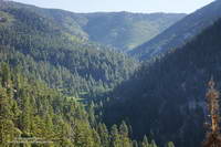
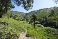
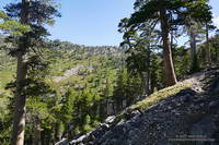
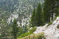
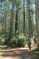
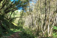
After visiting the fault zone we ran across the Point Reyes Peninsula to the coast using the Bear Valley, Mt. Wittenberg, Sky and Coast Trails. For the most part the trails were duff-covered, tree-lined, shaded and cool. For someone that runs mostly in Southern California this was practically nirvana. The previous Saturday I’d run a 50K race on a rocky, exposed course near Los Angeles in 90 degree temps and gusty Santa Ana winds. In the West San Fernando Valley the temperature this year has reached at least 95 °F every month from March through October. In July, August and September the highest temp each month was over 110 °F!

Alders along the Bear Valley Trail in Point Reyes National Seashore.

It was not 110 °F now. It was about 60 ocean-conditioned degrees. Brett and I had reached the first point where the beach narrowed. There was still room to run, but the beach narrowed even more ahead. We watched as a large wave broke and washed up to the rocks. It looked like the tide was going out, but we weren’t sure. Although the surf wasn’t huge, there was a consistent swell of maybe 6′-8′.

In between sets we took a look around the next corner and it looked sketchy. Debating, we watched as more waves washed up to the base of the cliffs. That part of the exploration would have to wait until another day with a lower tide!

Related post: Point Reyes – Sky Trail Keyhole Loop

Groundwater Replenished in Upper Las Virgenes Canyon

Small spring in upper Las Virgenes Canyon

The groundwater in upper Las Virgenes Canyon appears to have been replenished by the above normal rainfall last rain season.

The little spring pictured above has persisted through the dry season and farther up the canyon a tiny stream has trickled defiantly through the Summer. The mainstem creek in upper Las Virgenes Canyon isn’t flowing as it was during the Winter, but the sand at the crossing near the Cheeseboro connector trail remains damp.

It shouldn’t take a huge amount of rain to get the creek flowing again. We’ll see!

Related post: Los Angeles Rainfall Above Normal, But…

Some Summers Are Hotter than Others

Thunderstorm and Rocks - Sage Ranch Park - August 31, 2017.

The photo above is from an afternoon run at Sage Ranch Park on August 31, 2017, during our recent heat wave. The thunderstorm in the distance is over Santa Clarita.

Around the time the photo was taken the temperature at the Cheeseboro RAWS was 110 °F, with an “in the sun” fuel temperature of 119 °F. The temperature at Ahmanson Ranch, where I often run on weekdays, was probably higher. I was running at Sage Ranch to try and take the edge off the heat — even if the reduction in temperature was only a few degrees.

During the heat wave the high temperature at Pierce College in Woodland Hills in the West San Fernando Valley exceeded 100 °F on nine consecutive days (August 24 to September 3) and exceeded 110 °F on five consecutive days (August 28 to September 1). Numerous temperature records were broken in Southern California and across the state. On September 1, Downtown San Francisco set a new all-time record high temperature of 106 °F.

At my West Hills weather station the high temperature for the month of June was 109 °F; for July 111 °F; for August 112 °F; and so far this September the high has been 113 °F. If I’m not heat-acclimated by now, I never will be.

Kodiak 50 Mile 2017 – Smiling at the Finish

Nearing Gunsight on the Siberia Creek Trail

I had heard runners behind me since the last aid station. Now that we had passed the 8000′ high point of the course and were headed downhill, the group was going to pass me. I was at about mile 47 of the Kodiak 50 Mile race, and trying to shake off some demons that had been plaguing me for the last 7 miles.

It was my fourth Kodiak 50M and except for these last few miles it had been a mostly enjoyable day on the trails and forest roads of Big Bear Lake. There is no better run than a run in the mountains, and for my money no better 50 Mile race in Southern California than the Kodiak 50M. The Kodiak races (100M, 50M, Front 50K, Back 50K) have a character all their own, and at least for now — no lottery or histrionics. Just enter, train hard and then run!

Snow Slide Road before Snow Slide Spring.
Early in the race on Snow Slide Road.

The race had started before dawn near Fawnskin, on the north side of Big Bear Lake. It had been a chilly forty-something degrees at the trailhead, but warmed quickly as we ascended the Grays Peak Trail. Today would be the first day of a record-setting heat wave in SoCal and temps for the race would be the warmest in its five year history. By the time we reached Snow Valley and were descending the windless, exposed, south-facing slopes of Bear Canyon, the “in the sun” temps would be around 100.

The highlight of the 50M race for me is the climb out of Bear Canyon on the Siberia Creek Trail. This classic 7 mile ascent gains around 2910′ from Bear Creek (4770′) to the Champion aid station (7680′). You only get to do the Siberia Creek climb when the 50M is run counter-clockwise around the west end of the lake. This has been the case each year except for 2016.

The descent into Bear Canyon and climb out on the Siberia Creek Trail.
The descent into Bear Canyon and climb out on the Siberia Creek Trail. Click for a larger image.

Expecting it to be hot and knowing how tough this climb can be, I filled my Camelbak(TM) to the brim and also took an extra bottle. (Thanks Aaron and Lacey!) What I didn’t do was take the time to cool off in the stream. A couple minutes of cooling here might have helped keep the race demons at bay.

It was deceivingly cool in the shade of the trees along Bear Creek, but that didn’t last long. By the time I got to the top of the Siberia Creek climb I was just about out of water, dehydrated and over-heated. I laughed when I thought about how cold it was here in 2013. That year racers resting at the Champion aid station huddled in blankets and sipped hot soup to try and stay warm. Not today! I tried to take the time to rehydrate, but the clock was ticking. I grabbed a cup of ice and started up the fire road.

Elevation profile for the 2017 Kodiak 50M.
Elevation profile for the Kodiak 50M. Click for a larger image.

Though still generous, the cutoffs for the 50 milers have been substantially tightened since the 2015 event. Descending from the Grandview aid station to the Aspen Glen aid station I knew I was close to the cutoff and that was confirmed when a runner coming up the trail told me I only had 5 minutes remaining. The aid station personnel at Aspen Glen were phenomenal and I was in and out of there with water, my headlamp, and a couple of GUs in 48 seconds. I was excited to have made the cutoff, but knew I was going to have to push it to make the Finish by 9:00 p.m.

I had forgotten just how far east the Pine Knot Trail goes before ascending to Grandview. At one point it seemed the trail was going to descend all the way to the lake. I hadn’t seen a trail marker in some time and no other runners were in sight. I began to think I might have missed a turn and stopped to look more closely at the tracks on the trail. The imprints of a Brooks Cascadia and Altra Olympus stood out from the others. They were as good as a trail marker, and assured me I was still on course.

The ups and downs of the 2017 Kodiak 50M course.
The ups and downs of the Kodiak 50M course. Click for a larger image.

Eventually the Pine Knot Trail and I found our way back up to the Grandview aid station, but somewhere along the way I had become nauseated. Without asking, my body decided blood would be more useful for cooling and propulsion than for absorbing fluids and nutrients. My stomach had one message for me, “Sorry, we are closed!” It’s a common issue in longer runs, and given time, most runners work through it.

Unfortunately time was at a premium; all I could do is ralph, turn onto the Skyline Trail, and take the first steps toward the last aid station. I felt a little better after that and could sip a little water. The good news was that along with the sun, the temperature and my water requirements would be going down. What wasn’t going down was the trail. My recollection of this section was that it was a long five miles, but I did not recall all the ups along the way.

The last mile of the trail to the aid station paralleled the next section of the course and from time to time a runner would shout encouragement from the road above. I’d hoped to make it to the last aid station without having to stop and put on my headlamp and pulled into the station by the light of a quarter moon. Still nauseated, I put on my light and headed up the road.

Like a wrangler movin’ stock down from the high country, sweep Vanessa Kline encouraged the group of runners. We only had about 3 miles to go.

“You gotta keep running! You can do it! If you don’t run, you won’t make the cutoff!”

Most of the group did just that; they kept running and made the cutoff. Despite Vanessa’s best effort to get me moving a little faster, I crossed the finish line seven minutes after the 9:00 p.m. deadline.

I would have liked to make the cutoff, but I’m OK with the unofficial finish. I wasn’t trying to get UTMB points or to qualify for a 100 mile — I was running Kodiak for fun. I like the course and the way the event is organized. I’ve had faster Kodiak times and I’ve had slower. What didn’t change was that I was still smiling at the Finish.

Many thanks to R.D. Matt Smith, his supporting staff, all the volunteers, the sponsors, and runners. For all the results, photos and more info see the Kodiak web site and Facebook page. Also be sure to check out Kodiak 100M Winner Ruperto Romero’s interview on UltrarunnerPodcast.com. It’s a compelling and insightful story.

Some related posts: Kodiak 50 Mile 2015, Kodiak 50 Mile 2014, Kodiak 100 & 50 Mile Ultramarathons 2013

San Gorgonio Mountain: Falls Creek Loop, August 2017

Morning sun on trees above Mill Creek Canyon.

I was lost in thought and working up one of less-used trails that ascends San Gorgonio Mountain — the Falls Creek Trail. For every 100 people that do the mountain from the Vivian Creek and South Fork trailheads, I’d guess one or two ascend it by the Momyer – Alger Creek – Falls Creek – Divide Trail route.

I was thinking about many things — a rattlesnake I’d almost stepped on here; the old Falls Creek trail that ascended directly from the valley; whether it would be cloudy on the summit; what wildflowers I might see; and a multitude of other thoughts. I was also thinking about tracks.

Falls Creek drainage on San Gorgonio Mountain.

It’s a habit of mine to check the tracks on a trail. In addition to identifying the animal tracks, it’s fun to try and guess who might be on the trail ahead. Is it one person or a group? If it’s a group, how many? How long ago were the tracks made? Most of the shoe tracks on the trail today were old, but I kept getting a glimpse of one track that looked like it could have been from the previous afternoon or early this morning. My impression was that it was a solo hiker.

I had not caught the “hiker” by Alger Camp, so either the mystery person was fast and still on the trail ahead, or they had left Alger Camp early, or they had hiked in the day before and had camped farther up the trail. Or maybe there wasn’t a mystery hiker.

Falls Creek Trail near the stream at Plummer Meadows.

There is some very good running between Alger Camp and the Falls Creek drainage. Captivated by the running and my surroundings, I’d pretty much forgotten about the mystery hiker. I’d passed the turnoff to Dobb’s Camp about 45 minutes before and was working up toward Plummer Meadows when a person suddenly emerged from the trees 25 yards to my right, and rushed toward me, shouting, “Sir… sir!” There was such urgency in their quest I was startled, and it took me a moment to realize the individual was a Forest Ranger.

The Ranger said something like, “I assume you have a wilderness permit?”

I assured the Ranger I did, and pulled off my pack.

“Where are you headed?”

I responded, “The peak.”

Falls Creek Trail above Plummer Meadows and below Dollar Saddle.

The Ranger then asked if I was coming back the same way. I explained that after doing Gorgonio, I would be running down the Vivian Creek Trail and then down the road to the Momyer trailhead. Scrutinizing my day use permit, the Ranger asked a few more questions, and then thanked me and sent me on my way.

I was a little later getting to Gorgonio’s summit than the previous Saturday, and it was a busy place. Where last week there had been one person on the summit, this week there were around a dozen. Summits are generally happy places and the conversation can be about just about anything. Today the main topics were Lumix cameras and hummingbirds.

Vivian Creek Trail about a mile from the summit of San Gorgonio Mountain.

By the time I was headed down there was a fairly extensive deck of clouds over the mountain. But today the clouds didn’t have the convective instability and vertical development of the previous week. There would be no showers or thunder; the clouds would just keep the temperature comfortably cool.

In some ways the run down the Vivian Creek Trail is more demanding than the climb up from Momyer. The legs have some miles on them and the trail is very rocky. Last Saturday I hadn’t used poles doing the Dollar Lake – Dry Lake loop from South Fork. This week I did use them on the way up, and I think my legs felt better on the descent as a result.

Vivian Creek Trail above Vivian Creek.

The most dangerous part of the loop might be the mile and a half run from the Vivian Creek Trailhead to the Momyer Trailhead on Valley of the Falls Drive. In some stretches there’s not much of a shoulder and the road’s busy enough on a weekend that passing cars sometimes need all of it.

Even with the little bit of road-running, I much prefer the Falls Creek loop to chugging up and down Vivian Creek. It’s a favorite I always enjoy!

Some related posts: After the Lake Fire: The Dollar Lake – Dry Lake Loop on San Gorgonio Mountain, San Gorgonio Mountain: Falls Creek Loop October 2015, San Gorgonio High Line

After the Lake Fire: The Dollar Lake – Dry Lake Loop on San Gorgonio Mountain

Dry Lake in the San Gorgonio Wilderness

The north side of San Gorgonio Mountain was closed in June 2015 when the Lake Fire burned approximately 31,359 acres of forest, chaparral, sage, pinyon and Joshua tree habitat at elevations ranging from about 10,700′ to 5350′. As a result of the determined efforts of firefighters, only one residence and some remote outbuildings were lost.

Of the 30,487 acres reviewed by the Burned Area Emergency Response (BAER) team 4,327 acres (14%) were categorized as Unburned; 17,100 acres (56%) as having Low soil burn severity; 8,420 acres (28%) as having Moderate soil burn severity; and 640 acres (2%)with High soil burn severity. (Note that soil burn severity isn’t necessarily synonymous with fire intensity and fire effects such as tree loss.)

I’d been keeping an eye on the Alerts & Notices section of the San Bernardino National Forest web site to see if the Lake Fire closure order would be renewed. I was curious to see the extent and impacts of the Lake Fire and how the area was recovering. Plus, the Dollar Lake – Dry Lake keyhole loop is an outstanding trail run — one of the best in Southern California. In addition to climbing San Gorgonio Mountain (11,499′), it encompasses some of the most scenic areas on the peak.

The area’s trails reopened July 20. The weekend prior to the reopening San Gorgonio Wilderness Association volunteers worked on the South Fork and Dry Lake Trails, clearing a number of large trees, removing debris and other hazards and improving the trail tread.

A week and a half after the opening I pulled into the South Fork parking lot on Jenks Lake Road, excited to get on the trail. There was a slight chance of thunderstorms in the forecast, and I hoped to be off the summit and on my way down by 10:30 or 11:00.

Most of the run is in the San Gorgonio Wilderness and a wilderness permit is required. Check a map, but the general sequence of trails is the South Fork Trail, Dollar Lake Trail, Divide Trail, Summit Trail, Sky High Trail, Dry Lake Trail and then back down the South Fork Trail to the trailhead. This Google Earth image shows the western part of the Lake Fire burn area in relation to San Gorgonio Mountain and some of the area’s trails.

On this particular run I also wanted to check out the Fish Creek Trail and the “use trail” down to Lodgepole Springs and Dry Lake, so rather than continuing down the Dry Lake Trail from Mineshaft Saddle, I turned right (east) and followed the Fish Creek Trail to Fish Creek Saddle.

There were some downed trees and a lot of fire debris on the Fish Creek Trail. Extra care was required and I probably hiked as much of it as I ran. As I worked toward Fish Creek Saddle I could not tell how much of the canyon leading down to Lodgepole Spring had burned. The slopes on the southwest side of Grinnell Mountain had burned and some areas along the Fish Creek Trail had burned as well. Whether I descended to Lodgepole Spring from Fish Creek Saddle or returned to Mineshaft Saddle would be a judgment call.

Arriving at Fish Creek Saddle I was glad to see the forest was intact. The path down to Lodgepole Spring looked promising, but had not been used in some time. As it turned out most of the trees along the path had not burned. In places, runoff from the burned slopes above had resulted in some erosion and small flows of sandy soil. There were also the usual downed trees, but other than being a little challenging to follow, the path was generally OK.

I was nearly off the trail when the “chance of thunderstorms” forecast materialized into threatening gray clouds, a few sprinkles, and a couple of rumbles of thunder.

Here are a few photos taken during the run.

Some related posts: Running San Gorgonio: Dollar Lake – Dry Lake Variation, San Gorgonio Mountain: Dollar Lake – Dry Lake Trail RunLake Fire MODIS Fire Detections