Category Archives: weather

Islip Saddle to Baden-Powell: No Worries About Snow Flurries

Mine Gulch and Mt. Baldy from Mt. Baden-Powell on June 8, 2019.
Mine Gulch and Mt. Baldy from Mt. Baden-Powell

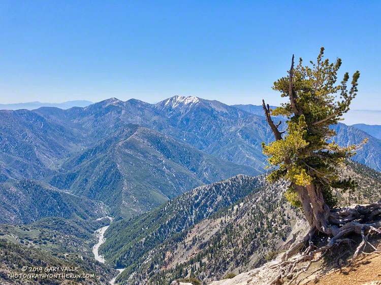
Each year, around Memorial Day, I like to do the out and back on the Pacific Crest Trail from Islip Saddle to Mt. Baden-Powell. It’s fun to see how much snow (if any) remains on Mt. Baden-Powell and to get an idea of how much snow there is on Mt. Baldy, San Jacinto Peak and San Gorgonio Mountain. It’s also a good way to continue acclimating to higher elevation.

Snow at 8750' near the junction of the PCT and Dawson Saddle Trail in the San Gabriel Mountains, near Los Angeles.
Snow at 8750′ near the junction of the PCT and Dawson Saddle Trail

This year I was a couple of weeks late getting to Baden-Powell, having done runs on Mt. Wilson Memorial Day weekend and Mt. Waterman the weekend after. That’s OK, over much of the holiday weekend it was cold and snowy at the higher elevations of the local mountains. The temperature at the Big Pine RAWS (6964′) was in the thirties all day Sunday, May 26, and it was certainly much colder than that at 9400′ on Baden-Powell.

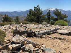
There were no worries about snow flurries and cold weather today! The weather was perfect for the run. Cool in the shade and warm in the sun.

Summit of Throop Peak in the San Gabriel Mountains, near Los Angeles.
Summit of Throop Peak.

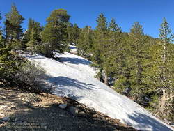
In some places between Throop Peak and Baden-Powell, there was still snow on the trail, but it could be avoided by moving to the sunny side of the crest. The last time there was more snow here in late May – early June was in 2010.

Perhaps because of the more seasonable weather, there were many (mostly) happy people on the trail that, like me, were thoroughly enjoying the wonderful day.

Related post: A Cool and Breezy Out and Back Trail Run from Islip Saddle to Mt. Baden-Powell

Painted Lady Butterflies in Upper Las Virgenes Canyon Open Space Preserve

Painted Lady Butterflies in Upper Las Virgenes Canyon Open Space Preserve. May 12, 2019.
Painted Lady Butterflies

Back in March, a profusion of painted lady butterflies in Southern California made headlines. The colorful insects were said to be passing through the area on their way to Oregon and other points to the north.

Two months later millions of the black, orange and white butterflies continue to be seen in the West San Fernando Valley, Upper Las Virgenes Canyon Open Space Preserve (Ahmanson Ranch), and other areas. Recently there has been an uptick in their numbers and there have been some remarkable displays of the flyers along local trails.

Painted lady in Upper Las Virgenes Canyon Open Space Preserve with the characteristic four eyespots on the hindwing.
Painted lady in Upper Las Virgenes Canyon Open Space Preserve with the characteristic four eyespots on the hindwing. Click for a larger image.

There are three very similar species of “lady” butterflies in the genus Vanessa — the painted lady (Vanessa cardui), the American lady (Vanessa virginiensis) and the west coast lady (Vanessa annabella). The Canadian Biodiversity Information Facility web site has a side-by-side comparison of these species and this post on BugGuide.net compares the American lady to the painted lady.

The lady butterflies I’ve looked at closely in Upper Las Virgenes Canyon Open Space Preserve have the identifying characteristics of the painted lady (Vanessa cardui). Here are an open-wing photo and a closed-wing photo of painted lady butterflies in Upper Las Virgenes Canyon Open Space Preserve.

This three-minute slow-motion video of painted lady butterflies in upper Las Virgenes Canyon reveals their fluid, bird-like flight. The purple flowers in the video are winter vetch, an introduced plant which is also more abundant this year.

The First Snakes of Spring

Red-tailed hawk with gopher snake at Upper Las Virgenes Canyon Open Space Preserve (aka Ahmanson Ranch).

When I left the house to drive over to Ahmanson Ranch, the temperature in West Hills was 92 °F. It had been five months since it was that warm.

It’s been my experience that the first hot weather of Spring is often associated with an uptick of snake sightings. Over the past seven days or so, I’d seen a very young rattlesnake and a  couple of small gopher snakes, but so far, that was it. With the warm weather, I thought I might see a snake on my run today, I just didn’t expect it to be in this manner.

Lost in thought, I was just about to the entrance of Upper Las Virgenes Canyon Open Space Preserve (aka Ahmanson Ranch) when I was startled by a large red-tailed hawk flying from right to left directly in front of me. Something long was dangling from its talons.

I stopped and watched as the raptor, fumbling with a large snake, awkwardly flew onto the top of a street light. The snake was dangling precariously from the light, and the bird seemed to be having a little trouble holding it.

The snake looked relatively heavy-bodied, and at the time I thought it might be a rattlesnake. That brought to mind a story of a hawk somehow dropping a rattlesnake into a car. However improbable, I didn’t want to approach the hawk and frighten it. I have enough problems with rattlesnakes on the ground and don’t need them falling from the sky.

I got what photos I could with my phone and headed out for a run.

You know how it is when you’ve seen a snake — anything sinuous on the trail sets off the brain’s snake alert. During my run I saw a couple of stick snakes, but no real ones. Finishing my run, I pressed the Start/Stop button on my watch and started walking across the parking lot.

Red-tailed hawk waiting to retrieve a dropped gopher snake at Ahmanson Ranch.
Red-tailed hawk waiting to retrieve a dropped gopher snake.

What? I squinted my eyes… Was the hawk still perched on the street light? No way, more than an hour had passed!

Continuing across the parking lot, I could see the hawk was still there, but where was the snake?

Cautiously, I approached the light post. I didn’t want to agitate the hawk or stumble onto an upset rattlesnake.

Sometime during my run, the hawk had dropped the snake — a gopher snake — and was waiting to retrieve it. It lay upside down on the street — sans its head. Rattlesnake or not, the hawk had removed the dangerous bit first.

I’ll be curious to see if the snake is still in the street tomorrow.

Update April 11, 2019. The following day (Tuesday) no trace of the snake remained, but the red-tailed hawk was still there — perched on an adjacent street light. On Wednesday the bird was gone.

After the Woolsey Fire: Malibu Creek State Park March 2019

Malibu Creek State Park following the Woolsey Fire and heavy Winter rains.

Parked in a turnout on Mulholland Hwy, I finished putting on sunscreen and then pushed the Start/Stop button on my watch to dial in the GPS and pair my HRM. Outside, it was a chilly 43 degrees. Sunrise was nearing and the strengthening March sun was forecast to push temps well into the 70s.

In the aftermath of Woolsey Fire, I’d returned to Malibu Creek State Park to see the wildflowers; gauge the response of the creek to heavy Winter rains; check on the health of the redwoods along the Forest Trail, and assess the ongoing recovery of the burned chaparral.

Today’s run of the Bulldog Loop would be a follow-up to two runs in the park in December 2018, which found a fire-ravaged landscape just beginning the long process of recovery.

Here are a few photos taken along the way.

Some related posts: After the Woolsey Fire: Bulldog Loop, After the Woolsey Fire: Malibu Creek State Park Redwoods, M*A*S*H Site and Bulldog Climb

Running to Ray Miller

Mountain bikers enjoying the view of Boney Mountain from Overlook Fire Road in Pt. Mugu State Park.

The Ray Miller Trailhead in Pt. Mugu State Park marks the western end of the Backbone Trail, a 68-mile scenic trail along the spine of the Santa Monica Mountains. The Ray Miller Trail’s long, winding descent into La Jolla Canyon is a favorite of runners and hikers, and a fitting end to those traversing the BBT from east to west.

My run this morning was to the Ray Miller Trailhead (and back) from Satwiwa, starting at the Wendy Drive trailhead in Newbury Park. The Wendy Drive Trailhead is very popular and is the starting point for many good runs, hikes and rides. To get an idea of the route options, see the detailed trail maps on the Pt. Mugu State Park page of VenturaCountryTrails.org.

Today I was looking to do a longer run, so didn’t take the usual route. On the way down Big Sycamore Canyon, I skipped the turns at Wood Canyon (Hell Hill), Wood Canyon Vista Trail (BBT) and Fireline Trail and at Overlook Fire Road, some eight miles into the run, finally headed uphill.

View of the Pacific, Anacapa Island and Santa Cruz Island from the Ray Miller Trail
View of the Pacific, Anacapa Island and Santa Cruz Island from the Ray Miller Trail.

The top of the Ray Miller Trail is a stout 2.5 -mile climb from the bottom of Overlook Fire Road. Along the way there were excellent views of Sycamore Canyon, Serrano Valley and Boney Mountain.

About a half-mile down the Ray Miller Trail there is a popular overlook of the coast. The day was clear and there were stunning views of the Pacific and the Channel Islands. Brushed by whispers of wind, the cerulean blue Pacific filled my view for much of the descent to the parking lot.

It was an odd feeling to run down to the parking lot with runners who were cheerfully finishing their morning run, knowing that I had many more miles to go. After a quick stop at the water spigot, I turned, and sighed, and took the first steps back up the hill and toward Satwiwa.

Here are a few photos taken along the way.

Related post: Ray Miller Training Run

Cool Running in the Simi Hills

Cool running at Ahmanson Ranch in the Simi Hills.

For the last couple of days of January, all of February, and the first third of March, the temperature at Downtown Los Angeles (USC) and many other Los Angeles area locations did not reach 70 °F!

Will have to think of days like today when it’s 100 degrees and I’m picking foxtails out of my socks and shoes!