Category Archives: nature|wildfire

Two Sides of Strawberry Peak – Spring 2021 Update

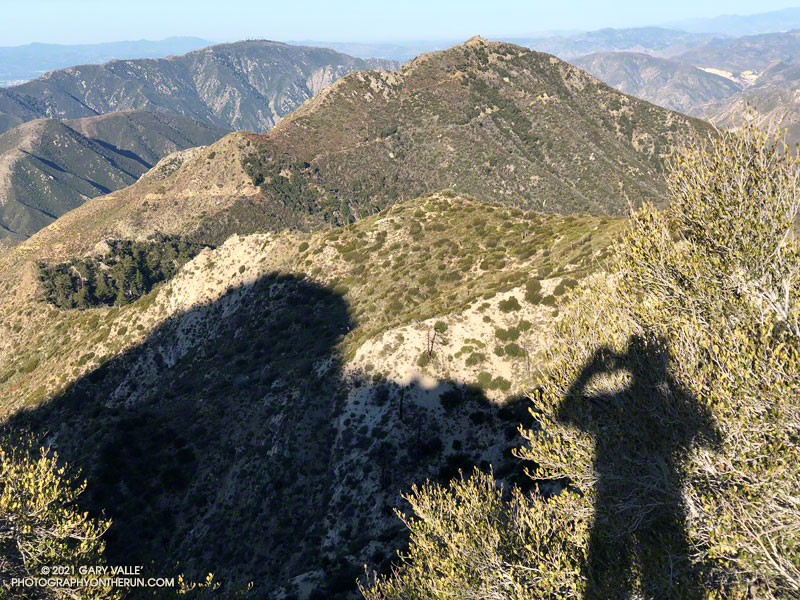
Josephine Peak and Mt. Lukens from the northwest ridge of Strawberry Peak

The photo above — of Josephine Peak — is the reciprocal view of this photo of Strawberry Peak. The photo of Strawberry from Josephine shows the dogleg approach along the ridge that connects Josephine Saddle to the northwest ridge of Strawberry Peak.

Strawberry has always been popular, but because of the Pandemic and fire closures, there has been an increase in the number of people doing the peak. Not having done the peak for a couple of years, I was curious to see if the condition of the use trail on Strawberry’s northwest ridge had changed.
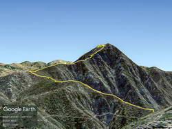
Google Earth image of Strawberry Peak from Josephine Peak, with GPS track of route from Josephine Saddle to summit
Google Earth image of Strawberry Peak from Josephine Peak, with GPS track

Given my early start, I was surprised to find the small parking area for the Colby Canyon Trail nearly full. I don’t know where all those people went, because I passed only one small group on the way to Josephine Saddle, and I didn’t see anyone between Josephine Saddle and the summit. There was a group on the summit, but they had hiked the trail from Red Box.

The last time I did the loop over Strawberry was April 2019. At that time sections of the use trail along the ridge leading to the upper northwest ridge of Strawberry were badly overgrown. This time around, increased usage has generally improved the path along the approach ridge. Plus, there has been some work done on the section of trail that was the most overgrown. However, to benefit, you have to stay on the trail. It wanders all over the place, and if you get impatient, you’ll be fighting your way through thick, thorny brush.
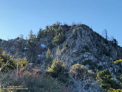
Upper northwest ridge of Strawberry Peak.

There was a little patchy snow on the steep, deeply shaded, north face of the peak. The snow was generally left of the normal rock climbing route up the northwest ridge. The patch or two on the route were easily avoided. Early or late season, this more technical section can be like a deep freezer. Today, it was cool, but comfortable. As mentioned in other posts, the steep, upper part of Strawberry’s northwest ridge requires good route-finding and some rock climbing skill. It is important to stay on route.

The steep section of the ridge ends a little below the top of Strawberry. I paused there for a moment to enjoy the view… Was that music I heard coming from the summit?

It was. The group that was on the summit was kind of encamped there. It looked like they might be a while, so I just said hi, and started down the east side of the peak.

I expected a lot of people to be on the trail up Strawberry from Red Box. It was busy, but seemed about normal for a Sunday in Spring with idyllic weather. There were fewer large groups coming up from Red Box than in April 2019.
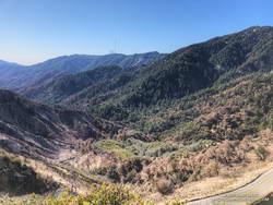
Upper West Fork near Red Box following the Bobcat Fire
Upper West Fork near Red Box from the Strawberry Trail. Mt. Wilson is in the distance.

At Red Box I stopped to take a look at how the 2020 Bobcat Fire had impacted the upper part of the West Fork drainage. There was a substantial fire scar on the left side of the canyon, but the right side of the canyon looked better than I expected. An upcoming post will include an interactive 3D visualization of the Soil Burn Severity in the Bobcat Fire area, along with the GPS tracks of some popular trails.

For the first time in a long time, I didn’t encounter any mountain bikers on the Gabrielino Trail between Red Box and Switzer’s. There were plenty of tire tracks, so I must have been between groups. I did encounter two misplaced hikers. They stopped me and asked how much farther it was to the falls. Unfortunately, they had gone the wrong direction on the trail from Switzer’s, and were several miles from Switzer Falls.

At Switzer’s, I chugged up the access road to Hwy 2, and then ran on the verge next to road back to the Colby Trailhead. Somehow, more cars were packed into the small parking area.

Starting and ending at the Colby Trailhead, the loop is a little over 12 miles with about 3200′ of elevation gain/loss. Starting at Clear Creek adds about a mile to the loop. Some prefer to do it as keyhole loop, returning to Josephine Saddle from Lawlor Saddle using the Strawberry and Colby Trails. I haven’t done it that way, but the mileage looks to be only slightly less than the full loop through Red Box.

Some related posts: Strawberry Peak

Skyline to the Sea – Fall 2018

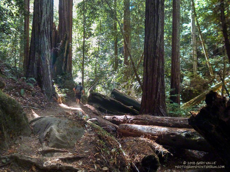
Towering redwoods along the Skyline to the Sea Trail, Big Basin Redwoods State Park

Update July 20, 2020. Here’s a Google Earth image of a CZU August Lightning Complex Fire perimeter from the National Interagency Fire Center (NIFC). The date and time of the perimeter is indicated. My GPS track from the PCTR Skyline to the Sea Marathon in Castle Rock and Big Basin Redwoods State Parks is also shown. The locations of all placemarks and trails are approximate. For official information see the CAL FIRE CZU August Lightning Complex and InciWeb CZU August Lightning Complex incident pages.

There’s a reason that Skyline to the Sea is Pacific Coast Trail Run’s biggest event. Close your eyes and picture your ideal trail. The trail of your dreams might be hard-pressed to match the appeal of the Skyline to Sea Trail.

There is something magical about running in an old-growth redwood forest. Established in 1902, Big Basin Redwoods State Park was the first state park in California. It’s redwoods reach 2000 years in age, 328 feet in height and 18.5 feet in width!

The Skyline to the Sea Trail has a net elevation loss, but enough uphill to get your attention. Many miles of the trail are as smooth as a carpet, but some are rocky, root-strewn and technical. It is often cool under the dense forest canopy, but it can also be warm and humid. I was surprised to see an “Emergency Water” stash a mile before the last aid station. In some years it is well-used and much appreciated.

The Park supports a vast variety of animal and plant life. Some plant species can only be found in the Park and a seabird (Marbled Murrelet) nests in its old-growth conifers.

In some years one park species can add extra adrenaline to the race. This year Brett (my son) and I were counting down the miles to mile 4.0 of the Marathon. The R.D. had reported encounters with the beasts at that point of the 50K on Saturday. About 20 yards before mile 4.0 Brett saw what looked like a “cloud of dust” and shortly after that we heard agitated voices from the runners ahead.

In it for the full experience, we — and several other runners — plowed headlong into the cloud. The yellowjackets didn’t like that. A number of us were stung; some several times. The day before a runner in the 50K was stung 18 times.

Yellowjackets or not, running the Skyline to the Sea Marathon was like running a 26 mile nature trail and one of the finest courses I’ve done.

Many thanks to R.D. Greg Lanctot and Team PCTR and all the volunteers that helped with the event. For all the results and more info see the Ultrasignup event page, PCTR’s web site and Facebook page.

Here are a few photos taken along the way. Mileages specified are from my fenix 3 and are approximate.

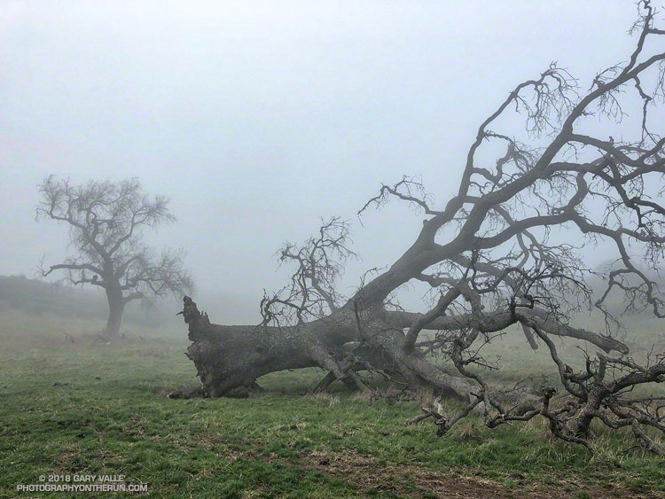
Fallen Oak

A large valley oak along Rocky Peak fire road that toppled following five years of drought.

The fallen oak pictured above — one of the larger valley oaks along Rocky Peak fire road — toppled over in the summer of 2016 following five years of drought. Fire and drought are a natural part of the valley oak’s habitat and the trees have evolved to withstand ordinary variations in their environment. However, severe fires or extended droughts, or fire in combination with drought can overcome the tree’s defenses. The drought may have been the culminating factor in the felling of this oak, but fire and other factors may have also played a role.

Base of large valley oak along Rocky Peak fire road that toppled following five years of drought.
Base of large valley oak that toppled following five years of drought. Click for larger image.

According to the Fire Effects Information System (FEIS), the heart-rot fungus Armillaria mellea is usually present in valley oaks and larger oaks tend to be hollow or rotten in the center. The toppled oak was hollow near its base and its interior appears to have been blackened by fire. The FEIS describes instances where the decaying wood in the interior of older valley oaks could ignite in a fire, but leave the exterior bark uncharred.

What fire might have burned the tree? There are two possibilities: the 2008 Sesnon Fire and the 2003 Simi Fire. It probably wasn’t the Sesnon Fire — this photo of the tree, taken about a month after the Sesnon fire, shows little impact. I couldn’t find a photo of the tree following the Simi Fire, but photos taken nearby show a severely burned landscape. Ultimately, it appears fire and drought weakened the tree, accelerating its heart rot and weakening its roots to the point it could no longer support itself.

Photos of the fallen oak are from this morning’s foggy run along Rocky Peak fire road.

Related post: Ahmanson Blue Oak Succumbs to Climate ChangeChumash Trail – Sesnon & Simi Fires

Mt. Wilson Fire and Mt. Wilson Area Trails

October 2017 Mt. Wilson Fire and Mt. Wilson Area Trails

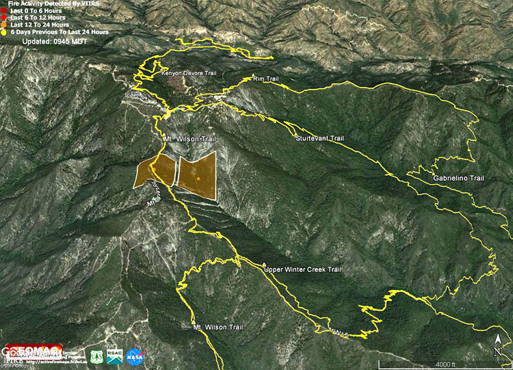
The Google Earth image above shows the VIIRS fire detections from the Wilson Fire. The data is from USDA Forest Service Geospatial Technology and Applications Center Active Fire Mapping Program. The square markers show the approximate location of yesterday’s detected fire activity. The markers do not indicate the areal extent of the fire. This Forest Service Briefing Map shows the completed line and uncontrolled fire line earlier today.

The fire started before dawn yesterday and according to a tweet from @Angeles_NF at 9:31 this morning was 25% contained and at 50 acres.

The yellow traces are GPS-based tracks of trails in the area. The tracks are subject to various errors and should be considered approximate.

After the Lake Fire: The Dollar Lake – Dry Lake Loop on San Gorgonio Mountain

Dry Lake in the San Gorgonio Wilderness

The north side of San Gorgonio Mountain was closed in June 2015 when the Lake Fire burned approximately 31,359 acres of forest, chaparral, sage, pinyon and Joshua tree habitat at elevations ranging from about 10,700′ to 5350′. As a result of the determined efforts of firefighters, only one residence and some remote outbuildings were lost.

Of the 30,487 acres reviewed by the Burned Area Emergency Response (BAER) team 4,327 acres (14%) were categorized as Unburned; 17,100 acres (56%) as having Low soil burn severity; 8,420 acres (28%) as having Moderate soil burn severity; and 640 acres (2%)with High soil burn severity. (Note that soil burn severity isn’t necessarily synonymous with fire intensity and fire effects such as tree loss.)

I’d been keeping an eye on the Alerts & Notices section of the San Bernardino National Forest web site to see if the Lake Fire closure order would be renewed. I was curious to see the extent and impacts of the Lake Fire and how the area was recovering. Plus, the Dollar Lake – Dry Lake keyhole loop is an outstanding trail run — one of the best in Southern California. In addition to climbing San Gorgonio Mountain (11,499′), it encompasses some of the most scenic areas on the peak.

The area’s trails reopened July 20. The weekend prior to the reopening San Gorgonio Wilderness Association volunteers worked on the South Fork and Dry Lake Trails, clearing a number of large trees, removing debris and other hazards and improving the trail tread.

A week and a half after the opening I pulled into the South Fork parking lot on Jenks Lake Road, excited to get on the trail. There was a slight chance of thunderstorms in the forecast, and I hoped to be off the summit and on my way down by 10:30 or 11:00.

Most of the run is in the San Gorgonio Wilderness and a wilderness permit is required. Check a map, but the general sequence of trails is the South Fork Trail, Dollar Lake Trail, Divide Trail, Summit Trail, Sky High Trail, Dry Lake Trail and then back down the South Fork Trail to the trailhead. This Google Earth image shows the western part of the Lake Fire burn area in relation to San Gorgonio Mountain and some of the area’s trails.

On this particular run I also wanted to check out the Fish Creek Trail and the “use trail” down to Lodgepole Springs and Dry Lake, so rather than continuing down the Dry Lake Trail from Mineshaft Saddle, I turned right (east) and followed the Fish Creek Trail to Fish Creek Saddle.

There were some downed trees and a lot of fire debris on the Fish Creek Trail. Extra care was required and I probably hiked as much of it as I ran. As I worked toward Fish Creek Saddle I could not tell how much of the canyon leading down to Lodgepole Spring had burned. The slopes on the southwest side of Grinnell Mountain had burned and some areas along the Fish Creek Trail had burned as well. Whether I descended to Lodgepole Spring from Fish Creek Saddle or returned to Mineshaft Saddle would be a judgment call.

Arriving at Fish Creek Saddle I was glad to see the forest was intact. The path down to Lodgepole Spring looked promising, but had not been used in some time. As it turned out most of the trees along the path had not burned. In places, runoff from the burned slopes above had resulted in some erosion and small flows of sandy soil. There were also the usual downed trees, but other than being a little challenging to follow, the path was generally OK.

I was nearly off the trail when the “chance of thunderstorms” forecast materialized into threatening gray clouds, a few sprinkles, and a couple of rumbles of thunder.

Here are a few photos taken during the run.

Some related posts: Running San Gorgonio: Dollar Lake – Dry Lake Variation, San Gorgonio Mountain: Dollar Lake – Dry Lake Trail RunLake Fire MODIS Fire Detections

Pinos to Abel Plus

Western terminus of the Vincent Tumamait Trail.
Grouse Mountain from the Vincent Tumamait Trail near Cerro Noroeste Road

I was glad I didn’t turn around and head back to the car. At the beginning of the run smoke from the Whittier Fire (near Lake Cachuma) covered Mt. Pinos in an ugly shroud. Fortunately, a couple of hours into the run, the wind shifted to the north, removing the smoky veil and greatly improving the visibility and air quality.

Hikers on the Vincent Tumamait Trail near Mt. Pinos.

Even it was smoky, at least the weather was cool. Following the torrid conditions at the Mt. Disappointment 50K the previous Saturday, and hot weather during the week, cool was good.

Mt. Pinos is often a good choice for escaping the triple digit heat of a Los Angeles heatwave. The elevation of the Chula Vista trailhead (8350′) is higher than the highest trailhead on Angeles Crest Highway — Dawson Saddle (7909′) and about 1000′ higher than the popular Inspiration Point (7370′) trailhead on the PCT.

Chumash spirit tower on Sawmill Mountain.

My usual “Pinos to Abel” run starts at the Chula Vista trailhead and follows a dirt service road to the summit of Mt. Pinos (8831′). At the nearby wildlife viewing area it picks up the Vincent Tumamait Trail and heads west, taking a short detour to Sawmill Mountain (8818′) and the Chumash spirit tower, and then continues toward Mt. Abel (Cerro Noroeste). The trail ends at Cerro Noroeste Road, but a short climb up through the pine trees leads to the summit of Mt. Abel (8280+’) and Campo Alto. On the way back I usually run down the North Fork Trail to the spring at Sheep Camp, and sometimes extend the run by descending to Lily Meadows Camp (6250′).

Runners on the Vincent Tumamait Trail below Mt. Pinos.

It’s rare to see other runners doing the Pinos to Abel run. Dan and Dameon first passed me descending from Mt. Pinos. Our paths would cross several times over the course of the morning. They were running in the Mt. Pinos area for the first time and having a great time exploring the trails.

One of those times was on the top of Mt. Abel. They were thinking about hitting Grouse Mountain (8582′) on the way back to Pinos and asked about the route. The use trail to Grouse branches off the Vincent Tumamait Trail near a saddle ENE of the peak and about 0.3 mile west of the North Fork Trail junction. It leads to the northern summit of Grouse’s twin summits in about a quarter-mile.

Horse taking a drink at Sheep Camp.
What’s in the bag?

I didn’t do Grouse Mountain today, but did take the North Fork Trail down to Sheep Camp. Today, the plan was to just go a “little way” down the trail below Sheep Camp to see if a particular plant was flowering. Beyond Sheep Camp the North Fork Trail drops like a rock, and it turned into one of those, “I’ll just go a little farther down” kind of things. Before I came to my senses I’d lost nearly 1000′ in elevation while looking for the plant.

After chugging back up to the spring at Sheep Camp, I refilled my Camelbak(TM) and then continued up to the Vincent Tumamait Trail and headed east, retracing my steps to Mt. Pinos, and back to the trailhead.

Some related posts: Thunderstorm, Vincent Tumamait Trail