Category Archives: photography

Regrowth of Trees Along the PCT Following the 2002 Curve Fire

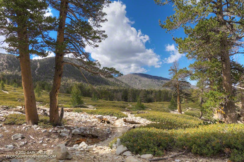
Young pines along the PCT about five miles east of Islip Saddle in an area burned by the 2002 Curve Fire
Tree regrowth along the PCT about five miles east of Islip Saddle

The Curve Fire started on Labor Day Weekend 2002, along Highway 39 in the San Gabriel Mountains. Between Mt. Islip and Throop Peak, the fire burned over the crest and down to Angeles Crest Highway. Between Throop Peak and Mt. Baden-Powell, the fire generally burned up to, but did not breach the crest.

Dead trees on a ridge west of Mt. Hawkins that were burned in the 2002 Curve Fire

The Curve Fire killed many trees, including some large, old-growth trees. The most common species along the trail between Mt. Islip and Throop Peak are white fir, Jeffrey pine, sugar pine, and lodgepole pine. Incense cedar also grows in the area, and limber pine is found on and to the east of Throop Peak. Here is a cross-section of a tree along the PCT about 3.0 miles from Islip Saddle. It is representative of the older trees killed in the Curve Fire.

Prior to the Curve Fire, the FRAP geodatabase of California fires has no record of a large fire that burned along the crest of the San Gabriels between Mt. Islip and Mt. Baden-Powell. The FRAP record extends back to the early 1900s, when the San Gabriel Timberland Reserve became Angeles National Forest. A study of mercury levels in Crystal Lake and newspaper accounts suggest the possibility that a large fire occurred in this area in 1878, or about 124 years before the Curve Fire.

I’ve run and hiked the PCT between Islip Saddle and Mt. Baden-Powell for many years, so have had the opportunity to follow the regrowth of conifers where the Curve Fire burned over the crest. Studying conifer regrowth in this area can provide insights into regrowth in the 2009 Station Fire and 2020 Bobcat Fire burn areas, and in areas burned by more than one of these fires.

The locations of the stands are shown in this Google Earth image, along with the areas burned by the Curve and Bobcat Fires. Of these four areas, Stand #1 is the only one burned by the Curve Fire and Bobcat Fire.

Stand #1

A June 2020 photo of conifer regrowth after the 2002 Curve Fire. These trees were obliterated by the Bobcat Fire.

This stand of young Jeffrey pines looked very healthy in June 2020. The area is about 1.5 miles east of Islip Saddle on the PCT, at an elevation of about 7440 ft. At that time a tree adjacent to the trail stood well overhead.

I almost ran past this area in July 2022. I had to double-check the mileage on my watch. Where were the trees? Here is a comparison of the area before and after the Bobcat Fire.

The young trees were more vulnerable than the mature trees in the area. Eighteen years of Curve Fire regrowth were completely obliterated.

Stand #2

This area of young trees is between Windy Gap and Peak 8426, about 3.0 miles east of Islip Saddle on the PCT, at an elevation of about 7900 ft. Some old-growth Jeffrey pines were killed here. This is what the area looked like on May 30,  2010.

Now the size of the trees ranges from seedlings a few inches tall to this very robust Jeffrey pine that is well over head height.

Stand #3

An assortment of young conifers growing along the PCT west of Mt. Hawkins in an area burned by the 2002 Curve Fire
An assortment of young conifers growing along the PCT west of Mt. Hawkins

This area of young trees is on broad ridge, west of Mt. Hawkins, about 4.2 miles east of Islip Saddle on the PCT. The Curve Fire ran down the ridge to Hwy 2, killing hundreds of trees. The elevation at the PCT is about 8500 ft.

Stand #4

This area of young trees is on a south-facing slope, just west of Throop Peak, about 5.1 miles east of Islip Saddle on the PCT. The elevation is about 8900 ft. Because of its aspect, the new trees are taller than in the other areas photographed. Here’s what this area looked like in May 2012, June 2016, and July 2022.

Some related posts: Did Lightning Start the 2002 Curve Fire, 3D Terrain View of Bobcat Fire Soil Burn Severity and Some Angeles National Forest Trails

Poodle-dog Bush Along the PCT Near Islip Saddle

Poodle-dog Bush along the Pacific Crest Trail near Islip Saddle with Mt. Williamson in the background.

Nope, my eyes weren’t deceiving me, the hiker was carrying his full-size poodle up the trail.

I was running down the PCT, east of Islip Saddle, after a run/hike to Mt. Hawkins and Throop Peak. I’m guessing the hiker was carrying his dog to keep it out of the Poodle-dog Bush on both sides of the trail.

Poodle-dog bush along the PCT above Islip Saddle in the San Gabriel Mountain
Poodle-dog bush along the PCT above Islip Saddle

Poodle-dog Bush (Eriodictyon parryi) is a fire-follower that can cause severe dermatitis in some people. In this case the plants sprouted following the 2020 Bobcat Fire.

The last big outbreak of Poodle-dog Bush followed the 2009 Station Fire. At that time many people were unfamiliar with its potential effects, and were caught off-guard.

The plant can get you in a couple of ways — the plant’s resin can affect sensitized people in a manner similar to poison oak, and the plant’s numerous hairs can break off and irritate the skin.

My experience with Poodle-dog Bush is described in the posts Contact Dermatitis from Eriodictyon parryi – Poodle-dog Bush and Getting Over Poodle-dog Bush Dermatitis.

Additional related posts: Trail Runners Describe Reactions to Poodle-dog Bush, Poodle-dog Bush Near the Top of the Mt. Wilson Trail

Downtown Los Angeles Ends Rain Year At 87% Of Normal

Sunflowers and Clouds by Gary Valle

Downtown Los Angeles (USC) ended the Rain Year (July 1, 2021 – June 30, 2022) with 12.40 inches of rain. This is about 87% of the 1991-2020 Climate Normal of 14.25 inches.

Percent of Average Precipitation Western U.S. July 1, 2021 to June 30, 2022.

In part because of large amount of rainfall during December — nearly 9.5 inches at Los Angeles — and the meager amount of rain the previous year, the area’s vegetation responded as if there had been above average rainfall. Wildflowers bloomed in abundance and some trails became overgrown.

Looking at the broader picture, much of California, Nevada and western Arizona recorded below average precipitation, exacerbating water supply issues in the Southwest.

Some related posts: A Lot of Bluster, But Not Much Rain, Malibu Creek December 2021 Floods, Running Between Storms on the Trippet Ranch Loop, Trippet Ranch Loop Plus the Santa Ynez Trail

Not So Flat Las Llajas Canyon

Cliffs along Las Llajas Canyon Road/Trail

Earlier, as I was running up Las Llajas Canyon, I thought of a conversation I had with a runner during a 50K. The runner was from southern Florida, and talked about the difficulty of finding a good hill to run. It sounded like the main options are overpasses, bridges, buildings and stadiums.

Las Llajas Canyon Road/Trail near Evening Sky Drive.

In Southern California we have the opposite problem. It’s hard to find a trail run that doesn’t have hills. And the longer the run, the more likely it is you’re going to be running some hills.

The out and back in Las Llajas Canyon is one of the flatter runs that I do. From Evening Sky Drive it’s about 3.5 miles up to where the trail forks. There is a sign at the split indicating that the left fork leads to a private ranch, and the right fork connects to Rocky Peak Road.

Pass between Las Llajas and Chivo Canyons
Use trail to pass between Las Llajas and Chivo Canyons

On rested legs, the run up Las Llajas from Evening Sky Drive seems pretty flat. Over the 3+ miles up the canyon, the elevation gain is around 565′. That’s not a huge amount, but it’s roughly the equivalent of climbing 56 floors or 900 stairs. After leaving the Marrland aid station at 20 miles, runners doing the Rocky Peak 50K discover that the run up the canyon isn’t as flat as it looks!

If you want more distance or elevation, there are a couple of ways to extend the Las Llajas out and back. One is to take the right fork at the sign and continue up to the top of the hill just before Rocky Peak Road. This adds about 2 miles and 600 feet of elevation gain.

Peak at the head of Chivo Canyon from the pass between Las Llajas Canyon and Chico Canyon.
Peak at the head of Chivo Canyon.

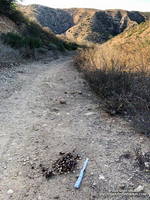
Another interesting way to extend the run, is to do the variation I was doing this morning. About halfway down the canyon on the way back, on the right, is a use trail. The use trail is about 1.6 miles from the turnaround point at the fork at the ranch sign. It is just past the area where steep cliffs tower above the road on the right, and is very easy to miss.

After turning right onto the use trail, about a half-mile up the trail splits. One trail switchbacks to the right and continues up to the top of cliffs and an old seashell grit mine; the other trail continues up the canyon to a  pass between Las Llajas and Chivo Canyons.

The trail over the pass leads to a well-used trail that connects Chivo Canyon to Las Llajas Canyon near Evening Sky Drive. Some refer to this trail as the “Marr Ranch Trail.” This variation adds about 1.3 miles and 500′ of elevation gain.

Yellow mariposa lily (Calochortus clavatus) along the Marr Ranch Trail
Yellow mariposa lily along the Marr Ranch Trail

Here’s an interactive, 3D terrain view of a GPS track of today’s route, as well as the variation that continues to Rocky Peak Road. The map can be zoomed, tilted, rotated, and panned. To change the view, use the control on the upper right side of the screen. Track and placename locations are approximate and subject to errors. Poor weather, and other conditions may make this route unsuitable for this activity.

After I got back from the run, I was curious to see what hilly trails there are in Florida. A quick search turned up the Hilly Trails In Florida page of the Florida Hikes web site. Anybody up for doing Mount Cockroach?

Some related posts: Exploring Las Llajas, Top of Las Llajas, Marr Ranch Wildflowers
Forest Run

Coast redwood along the Forest Trail in Malibu Creek State Park

The nasal bellowing of a bullfrog shook the morning, but didn’t disturb the mirror-like surface of Century Lake. I had paused along the Forest Trail in Malibu Creek State Park to take in my surroundings. Here and there glimmers of sunlight reflected from the base of the reeds along the opposite shore. Birds called, flowers bloomed and Nature continued to work in its wonderous way.

Canyon sunflower along the Lookout Trail in Malibu Creek State Park.
Canyon sunflower along the Lookout Trail.

My run had started at the Cistern Trailhead on Mulholland Highway and then wandered about the Reagan Ranch area. The Lookout and Yearling Trails had been thick with mustard and badly overgrown. The plants had been wet with dew, and my black sleeves and shorts had been liberally sprinkled with the bright yellow flowers. A few ticks had also hitched a ride, but were removed before they could bite.

It had been a relief to get back to the Cage Creek Trail and descend to the Crags Road Trail and Malibu Creek. The logs extending across the creek from the washed out bridge had been rearranged, making it easier to cross.

Log crossing across Malibu Creek on the Crags Road Trail, near the Forest Trail junction.

No other trail in the Park is quite like the Forest Trail. The trail isn’t part of a loop, doesn’t connect to other trails, and is only a half-mile long; but it feels like a trail you might find in Big Sur, Santa Cruz or the Bay Area. The forest is comprised primarily of coast live oak, California bay, and sycamore, but at several spots along the trail you’ll find coast redwoods.

Coast redwoods are not endemic to Southern California. All but one of the Forest Trail redwoods were planted over 100 years ago. The trees were severely impacted by the 2011-2015 drought, and only a few have survived. Even so, they are easy to spot — the large, deeply-furrowed, copper-brown trunk of a coast redwood is unmistakable.

Note: There is some poison oak along the Forest Trail, and this year some was protruding onto the trail.

Some related posts: The Malibu Creek State Park Redwoods Are Dying; Malibu Creek State Park Redwoods: Fighting the Drought; After the Woolsey Fire: Malibu Creek State Park Redwoods, M*A*S*H Site and Bulldog Climb

Dawn Songs, Wildflowers, and a Rocket Launch from the Phantom Trail

Sun and clouds in Malibu Creek State Park
Clouds & sun at Malibu Creek State Park, near the end of the Phantom Loop

I checked my watch — it was 6:13 a.m. I was part way up the Phantom Trail in Malibu Creek State Park, and had stopped to see if I could hear the launch of the Falcon 9 at Vandenberg Space Force Base.

I’d hoped to see the launch, but low clouds obscured the view skyward. Even so, there was a chance that a thin spot in the cloud deck might reveal the ship, as it propelled its classified payload into orbit.

All was quiet, except for the dawn songs of waking birds and the occasional car or motorcycle on Mulholland Highway. But then, just above the ambient sounds, I heard it — a constant dull roar somewhere to the west. I scanned the sky for any hint of an exhaust plume.

None was evident, but I suspect that if I had looked at the right spot at the right time, I might have glimpsed the rocket’s sun-bright flame. After searching and listening for a couple of minutes, I resumed working up the trail.

Phacelia along the Phantom Trail in Malibu Creek State Park
A sea of Phacelia along the Phantom Trail

Ka-boom! Even though my attention had turned to the trail, the distinctive, two-syllable report of a sonic boom broke my reverie. It had to be the Falcon 9 booster returning to the launch site. The boom wasn’t very loud at my location, but some living closer to Vandenberg apparently mistook the launch and sonic boom as an earthquake.

The remainder of the run went well. I’d run the Ahmanson 12K the day before, and the Phantom Loop (clockwise) was a good follow-up to that run.

I was a bit surprised just how overgrown some sections of the trail were. Mustard wasn’t the only plant crowding the trail, phacelia was as thick along the Phantom Trail as I’ve seen.

A showy patch of Chinese houses wildflowers along the Phantom Trail
Chinese houses along the Phantom Trail

With the cloudy, cool start to the day, the poppies were mostly closed, but several other species of wildflowers added color along the trail. Among them were Elegant Clarkia, Owl’s Clover and Chinese Houses.

Note: A little higher in the Santa Monica Mountains and farther to the west, Jonathan Stewart captured this video of the NROL-85 launch from Boney Mountain.

Some related posts: Phantom Trail: Trade-offs of a Wet Rainy Season; Redwoods, Raptors, and the Phantom Loop; Ladyface Via the Phantom Trail and Heartbreak Ridge