Category Archives: san gorgonio mountain

What’s the Shortest Route From South Fork to San Gorgonio’s Summit?

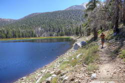
Spectacular afternoon on the Dry Lake Trail while running/hiking the Dollar Lake - Dry Lake keyhole loop on San Gorgonio Mountain.
Spectacular afternoon on the Dry Lake Trail.

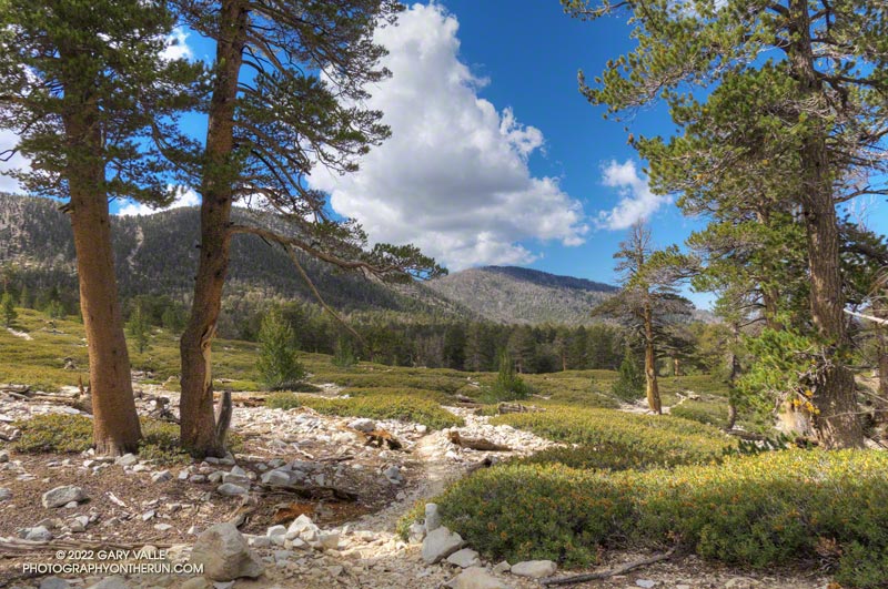
I wondered what the hikers would think when they reached this part of the Dollar Lake Trail.

A few minutes before, we had all reached the junction of the Dollar Lake and Dry Lake Trails at the same time. They hadn’t done the peak before and were debating which trail to take. When I mentioned that the Dollar Lake Trail is the shorter route to the summit, that’s the route they chose.

I guessed there might be a few choice words directed my way. About a half-mile beyond the junction, there is a long switchback on the Dollar Lake Trail that seems to never end. It’s about twice as long as any switchback on the Dry Lake Trail or Sky High Trail. With the mountain at your back, it takes the disbelieving hiker farther and farther away from their goal. How could it possibly be the shortest way to the summit?

But it is. The Dollar Lake Trail route is shorter — by about two miles. Following are the estimated mileages from the South Fork Trailhead to Gorgonio’s summit via the Dollar Lake and Dry Lake routes*:

SGWA handout – Dollar: 9.4  Dry: 11.3  Difference: 1.9

My GPS tracks – Dollar: 9.8  Dry: 11.5  Difference: 1.7

Tom Harrison Maps – Dollar: 10.0  Dry: 12.0  Difference: 2.0

*The Dollar Lake route uses the South Fork, Dollar Lake, Divide, and Summit Trails. The Dry Lake route uses the South Fork, Dry Lake, Sky High, and Summit Trails.

The combined route — Dollar up and Dry down — is one of the best mountain trail runs in Southern California. It’s a favorite, and the route I was doing today.

This morning the sky was mostly clear, and the temperature was mild. Later in the day, there was a chance of a thunderstorm, but I expected to be off the exposed trails higher on the mountain well before thunderstorms had a chance to build.

The first cumulus clouds popped up over the mountain around 10:00 a.m. An hour later — as I was crossing the summit plateau — the clouds were more extensive but with little vertical development.
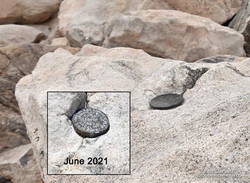
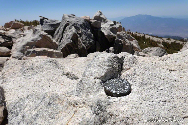
Defaced survey marker on the summit of San Gorgonio Mountain.

There were only a few people in the summit area. Some were on the west summit and some on the east. The twin summits are about 80 feet apart and nearly at the same elevation. Oddly, someone has defaced the survey marker on the west peak since the last time I was there — June 2021. With clouds all around, and 12 miles to go, I snapped a few photos and headed down.

I only saw one group of hikers on the Sky High Trail. They were working up the switchbacks at a good clip and would probably make the summit in an hour or so. Hopefully, the weather would hold for them!

It wasn’t until I was between the C-47 memorial and Mineshaft Saddle that I heard the first rumbles of thunder somewhere in the distance to the east or northeast.

As I continued down the mountain, I occasionally heard thunder in the distance but nothing nearby. There were some sizable cells to the east, but the weather behaved itself. At least where I was. I later heard it dumped at Onyx Summit, and flash flooding was reported at Joshua Tree.

For me, the weather was nearly ideal. Mild temperatures, light winds, and picturesque, sun-shielding clouds. It was short sleeves and shorts up and down. But on another day, it might not have worked out that way.

Here are a few photos taken along the way, and an interactive, 3D terrain view of the Dollar Lake – Dry Lake Loop.

Some related posts: San Gorgonio Mountain – June 2021; San Gorgonio Mountain Snow, Avalanches and Glaciers; San Gorgonio High Line

San Gorgonio Mountain – June 2021

GPS elevation marker on the summit of San Gorgonio Mountain

For the second time this month, I was crossing San Gorgonio’s summit plateau and relieved to be nearing the summit. Most of the uphill was done! My route was the same both times — South Fork, Dollar Lake, Divide, and Summit Trails up; then the Summit Trail, Sky High, Dry Lake, and South Fork Trails down. Here is an interactive, 3D terrain view of the route.

The changes along the South Fork Trail in just two weeks were remarkable to see. It may be Summer in the lowlands, but Spring was still in progress on the mountain. Withered-looking black oaks were now flush with leaves; newly sprouted ferns had unfurled, filling areas of the understory with bright green fronds; colorful wildflowers seemed to have appeared overnight.

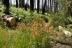
Ferns and paintbrush along the South Fork Trail, in an area burned by the 2015 Lake Fire.
Paintbrush and ferns along the South Fork Trail

Over the past two weeks, trailwork continued in the area. The start of South Fork Trail was rerouted for a second time since the 2015 Lake Fire, avoiding a very steep, root-filled section. In a continuing battle, some of the dead trees that had fallen on the trail had been cleared.

Earlier in the month a few small patches of snow could still be seen on the mountain, but today it was nearly gone. Only one tiny, stubborn patch of snow remained on the crest, near the summit. Most of Southern California recorded below average precipitation this past year. According to OntheSnow.com, nearby Snow Summit recorded 121″ total snowfall in the 2020-2021 season. This compares to 110″ in the 2019-2020 season and 143″ in the wet 2018-2019 season. A paltry 36″ was reported in 2017-2018.

As I started up the final rocky hill to the top of San Gorgonio, a small group of hikers scrambled down from the summit. As was the case earlier in the month, the summit area was nearly empty. On an ascent in September 2019 — when wilderness permits were not required — I’d estimated 40-50 people on, or around, Gorgonio’s summit. The restoration of the permits seemed to have made a big difference.

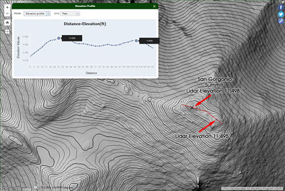
Relaxing on the summit, I looked over at another high point about 100 yards to the ESE. The traditional U.S.G.S. 1996 7.5′ San Gorgonio Mountain Quadrangle isn’t high enough resolution to show this secondary summit. From the official summit, the other point looks higher, and vice versa.

High resolution (1m) 3DEP Lidar data for the top of San Gorgonio Mountain
3DEP Lidar data for the top of San Gorgonio Mountain. Click for larger image.

Out of curiosity, following the run I checked the high resolution 3DEP Lidar data for San Gorgonio. It resolves the twin summits, and indicates the official (west) summit is about three feet higher.

In 1989, the “San Bernardino County Surveyors” determined the elevation of San Gorgonio Mountain to be 11,501.6 feet. They placed this small marker on summit. The USGS page Global Positioning Application and Practice discusses some higher precision GPS equipment and survey methods. The elevation of the mountain has probably shifted a little since that measurement was done.

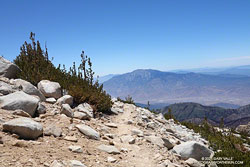
San Jacinto Peak from the Sky High Trail on San Gorgonio Mountain
San Jacinto Peak from 11,200′ on the Sky High Trail

After comparing notes with a runner doing the clockwise version of the route I was doing, I headed back down the Summit Trail to its junction with the Sky High Trail.

By their very nature, mountain trails are scenic, but the Sky High Trail is exceptionally so. Running down the Sky High Trail is what running in the mountains is all about. It is spectacular! That doesn’t mean it’s a cakewalk. The trail is rough, rocky, and crosses steep slopes. As with any trail on such terrain, snow on the trail can be a serious issue.

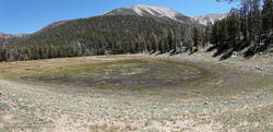
Dry Lake, San Gorgonio Wilderness, June 6, 2021
Dry Lake, June 6, 2021

The Sky High Trail ends at Mineshaft Saddle. From here, I picked up the Dry Lake Trail and continued down, down, down. Above Dry Lake, a section of trail pummeled by an avalanche in 2019 had been restored. Continuing, the trail winds down through a complex of glacial moraines above Dry Lake. and then follows the margin of a large moraine down to Dry Lake. The lake dried up early this year, and was already dry on June 6.

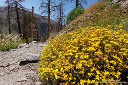
Golden yarrow along the Dry Lake Trail, San Gorgonio Wilderness
Golden yarrow along the Dry Lake Trail

It can be very warm in the afternoon on the Dry Lake Trail between Dry Lake and South Fork Meadows, but today gusty winds kept the temperature moderate. At South Fork Meadows, I gulped down a liter-bottle of water, enjoying the cool shade, and then finished the run.

Some related posts: San Gorgonio Mountain: Dollar Lake – Dry Lake Trail Run; San Gorgonio Mountain Snow, Avalanches and Glaciers; El Dorado & Apple Fire Perimeters and San Gorgonio Trails; After the Lake Fire: The Dollar Lake – Dry Lake Loop on San Gorgonio Mountain

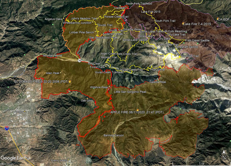
El Dorado & Apple Fire Perimeters and San Gorgonio Trails

Apple Fire Perimeter and San Gorgonio Trails

For official information see the El Dorado Fire incident page and Apple Fire incident page on Inciweb, and the San Bernardino National Forest website. National Forests in California have reopened to varying degrees. For more information, contact  the National Forest.

Here’s a Google Earth image of El Dorado and Apple Fire perimeters from the National Interagency Fire Center (NIFC) . The image acquisition timestamp of the perimeter is 9/22/2020 2008 (PDT) .

The 2015 Lake Fire perimeter is also shown. Some trails in the San Gorgonio Wilderness are also shown as yellow tracks. All map data are approximate.

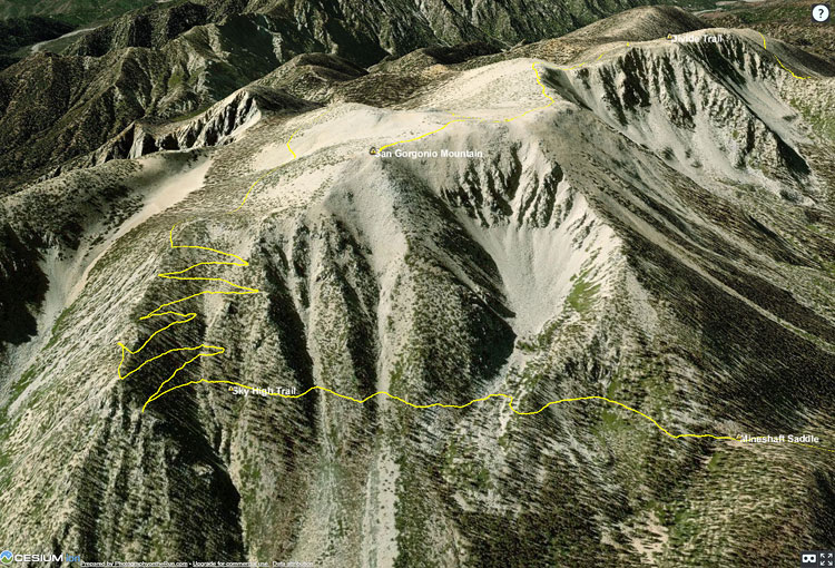
Here’s a 3D interactive Cesium view of the same perimeter and trails.

Visualizing Trail Runs and Other KML Data Using Cesium 3D High Resolution Terrain

Cesium ion 3D view of San Gorgonio Mountain

Google discontinued its Google Earth API/Plugin in January 2017. That technology was used on PhotographyontheRun.com for 3D visualizations of trail runs, fire data, and other data.

I’ve been looking at alternatives since then, and have recently implemented an interactive viewer using the CesiumJS and Cesium ion components of the Cesium 3D Geospatial Platform. No browser add-on or plug-in is required. The viewer uses the Cesium World Terrain high-resolution global terrain tileset, with resolutions to 0.5 meter. The West Coast of the US is one of the areas covered by this resolution.

Following are example 3D visualizations of some of my recent runs. The views are interactive and can be zoomed, tilted, rotated and panned. Click/tap the “?” in the upper right corner for help manipulating the scene. Mileages and elevation gains/losses are approximate.

San Gorgonio Mountain Trail Run (21 mi, 4700′ gain/loss)

The initial view is of San Gorgonio Mountain from the northeast, showing the trail to the summit and the Sky High Trail. The large cirque held one of several glaciers on San Gorgonio Mountain. The GPS track is from a run in September.

San Gorgonio Mountain Trail Run and Lake Fire Burn Area

Another view of San Gorgonio Mountain with the 2015 Lake Fire burn area added. The initial view is from the northwest. The GPS track is from my run in September.

Bulldog Loop Variation (17 mi, 3250′ gain/loss)

The initial view of this popular loop is from the northeast. This variation starts/ends at the Cistern Trailhead on Mulholland Hwy. The GPS track is from a run of the loop in September.

Three Points Loop Around Mt. Waterman (20 mi, 4000′ gain/loss)

The initial view is from the Buckhorn (east) side of the loop. The loop includes a segment of the PCT in Cooper Canyon. The GPS track is from a run in October.

Top of Reseda to Parker Mesa Overlook (18.5 mi, 3100′ gain/loss)

The initial view is from the northeast, on the Valley side of the route. The Musch, Garapito and Bent Arrow Trails were done on the way back from Parker Mesa. The GPS track is from a run in October.

An Out-of-the-Way Trail, Two Peaks, a Wheelbarrow, and Washington’s Monument

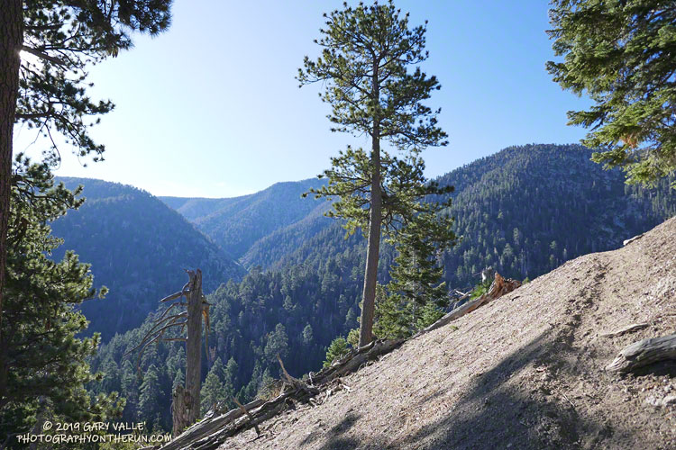
Forsee Creek canyon from the John's Meadow Trail in the San Gorgonio Wilderness.

Wow, what a fantastic trail, canyon, and morning!

The view above is from the John’s Meadow Trail, a circuitous trail that winds its way through a less-traveled part of the San Gorgonio Wilderness.

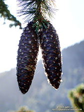
Sugar pine cones
Sugar pine cones along the John’s Meadow Trail.

The prominent canyon in the photo is home to Forsee Creek. During the last ice age, it held one of San Gorgonio’s small glaciers. I’d just crossed the Forsee Creek a few minutes before, and in a few hours would run past its source high on the crest — Trail Fork Springs.

The peak at the head of the canyon is East San Bernardino Peak (10,691′). Its summit marks the crest of the divide and the location of the San Bernardino Peak Divide Trail. That’s where I was headed, but the path would be anything but direct.

From the Forsee Creek crossing at 7270′, the John’s Meadow Trail climbs about 1000′ in 2.3 miles to join the Divide Trail at “wheelbarrow junction,” about 5 miles west of East San Bernardino Peak. From that point I worked up the popular and scenic Divide Trail, visiting Limber Pine Bench (9330′), Washington Monument (10,290′), and San Bernardino Peak (10,649′) along the way to East San Bernardino Peak.

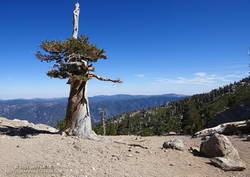
A weather-beaten lodgepole pine at Limber Pine Bench on the San Bernardino Peak Divide Trail.
Weather-beaten lodgepole pine.

Using this roundabout — but very scenic — route, it took me about the same time to reach San Bernardino Peak from the Forsee Creek Trailhead as it does to do San Gorgonio Mountain from the South Fork Trailhead. From San Bernardino Peak it’s a little less than a mile to East San Bernardino Peak and from there only about 0.75 mile to the lateral to Trail Fork Springs.

From the westernmost Trail Fork Springs junction with the Divide Trail the theme was downhill, downhill, and more downhill — about 3800′ of downhill over 6.7 miles.

The running on the Forsee Creek Trail was generally very good. I was glad I did the loop counterclockwise. The John’s Meadow Trail and its extension are enjoyably primitive — they appear to be “use” trails that have evolved over time. On the other hand, the Forsee Creek Trail is a constructed trail. It was designed as a pack trail, so is generally well-behaved. Great for going down, but a long haul up with a heavy pack!

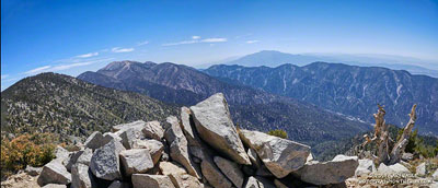
San Gorgonio Mountain and San Jacinto Peak from East San Bernardino Peak.
San Gorgonio and San Jacinto from East San Bernardino Peak.

Here are a few photos taken along the way, and here is an interactive Cesium ion view of the GPS trace of my route. The 3D view can be zoomed, tilted and panned.

Note: Water is generally more reliable and accessible on the John’s Meadow Trail than on the Forsee Creek Trail. Trail Fork Springs and Jackstraw Springs are seasonal water sources that may not have water. Check with the Mill Creek Ranger Station for the current conditions and more info.

San Gorgonio Mountain Snow Follow Up

Hiker working up the Sky High Trail on San Gorgonio Mountain in Southern California
Hiker on the Sky High Trail

One of the things I’d been curious to see when running the Kodiak 50K in mid-August was how the summit snow band on San Gorgonio Mountain was holding up. The answer turned out to be fairly well. Now, a few weeks later, I was back on Gorgonio, chugging up the South Fork Trail, and on my way to see if any snow remained on the mountain.

Runoff from thunderstorms during the week had left the trail rocky and rutted. From the views of the mountain I’d glimpsed from the trail, I wondered if the rain had also washed away any remaining patches of snow.

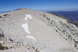
Snow band near the summit of San Gorgonio Mountain. September 7, 2019.
Snow band near the summit of San Gorgonio Mountain on September 7, 2019.

In addition to that question, I also want to follow up on my earlier “field checks” this Summer and see how much water there was in Dry Lake, and if any snow remained in the avalanche debris above Dry Lake.

I was about a quarter-mile from the Dry Lake – Dollar Lake junction at South Fork Meadows, making decent time, when I heard footsteps behind me. I stepped to the side so he could pass, and we talked as we worked up the trail. Kevin said he’d been climbing in the Sierra just about every weekend and was really well-acclimated.

I asked him what route he was doing to the summit, and he said the Dry Lake route. I told him I was doing the Dollar Lake Trail route up and the Dry Lake route down. He was clearly moving faster than me and said he was shooting for a time of 4:20 to the summit. I mentioned the Dollar Lake route was shorter and faster, and depending on the number of stops for photos, I expected to get to the summit in around 3:45. We talked about some Sierra peaks and being in the mountains, and after a couple of minutes, he began to pull away.

Trail runner at Dry Lake on San Gorgonio Mountain
Dry Lake on September 7, 2019.

The early morning temperature had been a little more chilly than my earlier trips up Gorgonio this Summer. I debated pulling on my sleeves, but by the time I was in the sun on the Dollar Lake Trail, the temperature had warmed to a comfortable 50-something — perfect for ascending the peak.

The summit of San Gorgonio was a very busy place when I arrived. I’d estimate 40-50 people were on or around the summit. Most were part of one huge group that had come up Vivian Creek.

The good news was part of the summit snow band had not melted. Wow! It was September 7, and there was still snow in Southern California!

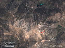
Copernicus Sentinel satellite imagery of snow on San Gorgonio Mountain on August 27, 2019.

Kevin caught up to me on the descent of the Sky High Trail. We’d both made the summit within a couple of minutes of our projections, leaving little doubt that the Dollar Lake Trail is the fastest route to the summit from the South Fork Trailhead.

I didn’t see any snow remaining in the avalanche debris above Dry Lake. The lake itself was in great shape, and the streams at South Fork Meadows were flowing nearly as vigorously as they had been a month ago.

I’ve added a couple of photos from this trip to the San Gorgonio Mountain Snow, Avalanches and Glaciers slideshow.

Update November 26, 2019. A small amount of snow from the 2018-19 season has survived on San Gorgonio Mountain until the first persistent snow of the 2019-20 season! Copernicus Sentinel satellite imagery from November 17, 2019 showed small patches of snow in two areas. The first winter storm of the season brought snow to the mountains a couple days later, and more snow is expected over the Thanksgiving holidays.

Update October 21, 2019. Copernicus Sentinel satellite imagery from October 21, 2019 still showed a few very small patches of snow on San Gorgonio Mountain. One of the patches is at a surprisingly low elevation of about 10,360′.

Update September 18, 2019. Copernicus Sentinel satellite imagery from September 18, 2019 still showed a few small patches of snow on San Gorgonio Mountain.

Related post: San Gorgonio Mountain Snow, Avalanches and Glaciers